Tripler Ridge Photos


You might also consider
More like Tripler Ridge
Recommended Reviews - Tripler Ridge
Start your review...

Reviews With Photos

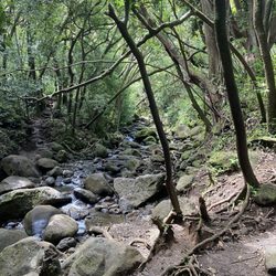
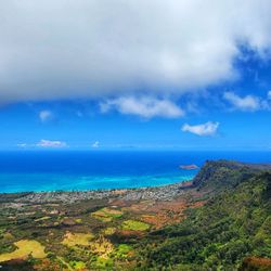
Tripler Ridge is a hike along a ridge that starts at Tripler Army Medical Center and ends at the summit of the Koolau mountains. People have hiked this trail starting at the back of the hospital but the easier, non-access-needed way to do it is to start at Moanalua Valley Neighborhood Park at the end of Ala Aolani Street. I suggest you not park in the parking lot as a neighbor who lives nearby has called the police to report people parking in the lot and leaving the City and County park to hike into the valley. It's a long, relatively flat hike from the park. There are several ways to access the summit. The only one I've taken entails hiking past the detour to the Kulana'ahane trail and continuing straight along the trail till you start climbing up the right side of Tripler Ridge. It's about an hour hike from here to the summit. If the weather is clear, you will be rewarded with breathtaking views of the Windward side and, looking back, to Moanalua Valley and the south shore of Oahu. Many people use parts of this valley hike to access the top of the Stairway to Heaven. It is possible to hike from the summit of Tripler Ridge along the Koolau Summit Trail in either direction but be very careful as the summit trail is narrow, crumbly and drops several hundreds feet, sometimes on both sides.

We chose Tripler Ridge to go to the Stairway to heaven. It was very nice change because he was usually we take the regular way + Moanalua Ridge. Tripler Ridge has more plans and trees around in comparison to the regular way. It was a little bit muddy. I recommend spikes if you have some. Have a great time and lots of fun.

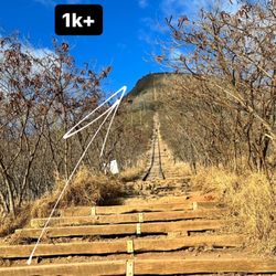
Review for Tripler Ridge Trail up to the electrical towers: The trail up to the electrical towers is a fully paved steep hill which makes it family friendly and baby wearing friendly. Technically one can push a stroller up the trail, but I would imagine it being quite challenging to push it downhill. We went on a hazy day, but I'd imagine the views on a clear day would be GORGEOUS!!! But then that would be scorching hot sun on your back as this trail is completely exposed to the elements without an ounce of shade. I'm not a fan of paved hikes, but since this trail has amazing views and many many more miles beyond the electrical towers I rated it as 2 stars. Hoping to explore past the towers soon!

I wasn't going to write a review because I didn't technically complete this hike. Then I thought about how my review might help other mommas or novice hikers... so here goes! This review is only for the paved part up to the tower/electrical lines. This portion totals about 2.6 miles roundtrip. I first hiked this trail with a group of other momma's and children. Park in the parallel parking spots on the side across from the homes. We followed the white sign that said something along the lines of "access for hikers." When you go past the sign, you make a left and step over a chain. The trail itself is easy to follow from here. It's paved all the way to the top (where you can then sneak off to the unpaved, ridge part). There is some incline at the beginning, but nothing that the average person can't handle. The views around you are beautiful. Be sure to stop and look behind you every now and again! Also, this is is a pretty well shaded hike. While this is a paved hike, I wouldn't recommend a stroller. I'm sure you could do it, but it seems like it would be a pain. The only reason I won't give this hike five stars is because I wasn't impressed with the views at the first "end point" by the tower. You couldn't see much of anything. Nonetheless, it's still a nice place to have a picnic or a quick snack before heading back down. Heading down is when you'll really get to take in some of the great views. I'm planning to do this trail again soon. Even though it's not the trail with the BEST views of the island... it's empty, well-maintained and offers a nice, safe option for cardio!

Note: Review for the trail up to the top view point next to the tower/electrical lines only. Beautiful walk that gets a bit steep so if you're talking and walking you may get a bit winded. On the way up, there are lots of small wild guava and bird life. The views get pretty good fairly quickly with ability to see Diamond Head and the Salt Lake/Pearl Harbor area. To access the trail head, you'll need to know someone who works or lives at Tripler and guests will likely need to show ID, so be prepared at the front gate. Parking is residential and signs mark the start. Don't forget to turn left into the trail's metal gate once a bit up hill on the asphalt. Good walking shoes are needed, as it might be tough to do in slippers. You will likely run into people walking their pets and also maybe a wild pig or two as we were told. There's also a chance of mosquitoes so bring some repellent. Like I said, we stopped at the top where the power lines are about 1.5 miles in, post this, the hike gets tough, sometimes muddy and is long--supposedly going all the way to Haiku Stairs (this is the 8-hour trek some other Yelpers are referring to). Given the chance I'd go back but be sure to put some good shoes on and bring repellent for my ankles! Other than that a camera phone and sunscreen are it to enjoy the gorgeous viewpoints! :)

This is one rigorous and dangerous Hike. Definitely "not" for beginners nor faint of heart. We began our hike at the beginning of Moanalua Valley Neighborhood Park at 0730am. Slip through the green gate which stops vehicle from going into the path. (Ignore the sign/ trail to the right of that gate). As you go through the Path you'll keep seeing a split, Just keep right. Also you will see a lot of pink and yellow or even blue ribbons along this path that leads to trails, Ignore them! I strayed away from my plan and took one of the yellow and pink ribbon trails just to end up in front of a stone wall that my group would never be able to climb. Lost 30mins up and down that trail. Keep going through Moanalua valley path and keep an eye for a wooden post on the RIGHT side that has a yellow number 12 on the top also refered to as marker 12. This is the beginning of your ascension towards tripler ridge. Once you go into marker 12's trail, it is a straight shot to tripler ridge summit. Tripler ridge summit will be a clearing with nice 360 degree view with Kaneohe right up front. At the very last leg of Tripler ridge is a good amount of ropes that's goes up pretty steep but I wouldn't consider this as rapelling up. Although this is where half of our group broke off and turned back. Those of us that kept going made a left from the Tripler summit and you'll be Trailing Ko'olau Which has a very narrow trail with nothing but a drop on both sides. We we're walking low because of the winds and of cours because of the cliffs on both sides Further down is a signal tower with winds kickin at you enough to give a 160 pound guy a good push off the cliff. Our plan was to keep going through this Ko'oloau trail and eventually get to Radio Station on top of Haiku stairs; but once we got to the signal tower, Me and the rest of the group made a decision that the winds further down is just too much, We do not see any ropes further down so we decided to turn around back to tripler ridge pretty much the same way we came in. We started heading back at 1 pm and gladly got back down by 4:30pm. At the end still feeling accomplished we got to the Tripler ridge summit and more than halfway through Ko'olau Trail. A bit dissapointed we didn't reach our goal to the top of Haiku stairs but it is what it is and this is a ver dangerous hike from the beginning. Still an awesome experience for anyone daring to go. Maybe next time. TIPS: I'd definitely plan this weather wise, we caught a bit of rain but it wasn't too bad. Not sure if the gusts up in Ko'olau ever settles down a bit but the weather was pretty clear with some fog when we we're up there. Gloves helped a LOT for those ropes and the inclines to save your legs from some work. I brought over 3Liters of water (3 tall bottles of water, I realized it should get lighter as I go anyways and alas, it came in handy when we realized we'll have to head back down same way we came in. Bring light snacks to keep you going. You will want a light jacket or windbreaker when you get to Ko'olau ridge. It would've pretty cold if not. Good hiking shoes is a must. I have a gopro Hero3 with me and my mistake was I kept using that bluetooth and wifi. Battery only lasted halfway.

So probably one of my favorite hikes so far. It is a long hike to the summit and right now the access through the army base is closed so if you turn right before the guard post and follow that road into the neighborhood an access road with a small metal gate will appear on the left. Park away from houses and make your way up the trail to a large concrete water tower and walk around to the right and eventually you should see some orange trail tape showing where to enter. A little ways in there will be a folding chair in a tree...yeah don't ask I have no idea. Just keep following that until to reach a fenced in area and follow it down to the left and around until you reach a paved road. Walk up that and just keep going straight. Also I was wearing shorts on this hike...big mistake the first portion is very overgrown with ferns so our shins were insanely scratched up by the end of it. Overall it is well maintained and once you reach the summit and go towards middle ridge someone has been putting in brand new ropes so a big thank you to that person. Make your way down middle ridge until you hit the road and we went right and eventually we arrived at the moanalua valley trail head where we staged our other car. Along the way there's some cool ruins and stuff to see if you aren't too tired. It took us around 8 hours but we spent a lot of time at the top taking in the views. Lots of water at least 3L per person.

Perfect short hike after work and a beautiful view to boot so one of my battle buddies is a fitness buff funny kind of like me only her arms put mine to shame!! Anyways last week Thursday was her birthday and of course she didn't want to do anything but work out so we decided to do a hike that I have never done before. we had a great time this was a great hike short but it definitely gets the blood pumping and for me it was a great second work out! I also like how they weren't bugs everywhere. This trail trail was also not crowded at all:) you do need to have access to hmm Tripler the hospital base area to enjoy this hike;) read more


6 years ago
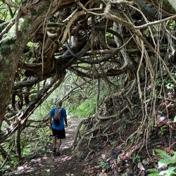
Doing the first part makes you feel like a never ending walkway. Like for real. It's uphill and paved but it never ends and it's steep. Then, you get past the antennas which you think is the half way mark. Definitely not. You start to walk in this overgrown part that looks like something out of The Lost World: Jurassic Park. Like raptors and Jeff Goldblume are about to come out. Past that you realize you're now in a different movie. Kong: Skull Island. Like maybe a giant spider leg will come out of the sky or maybe that bamboo you are holding isn't really a bamboo. It was muddy and overgrown at times. All trails rates it as hard and they were not lying. It's shades at some parts. But wear pants. I wore shorts. Big mistake. There's a swing there too if you're into looking for these. Parking was great as usual. It's in a neighborhood so be respectful ya'll. read more


Tripler Ridge is a hike along a ridge that starts at Tripler Army Medical Center and ends at the summit of the Koolau mountains. People have hiked this trail starting at the back of the hospital but the easier, non-access-needed way to do it is to start at Moanalua Valley Neighborhood Park at the end of Ala Aolani Street. I suggest you not park in the parking lot as a neighbor who lives nearby has called the police to report people parking in the lot and leaving the City and County park to hike into the valley. It's a long, relatively flat hike from the park. There are several ways to access the summit. The only one I've taken entails hiking past the detour to the Kulana'ahane trail and continuing straight along the trail till you start climbing up the right side of Tripler Ridge. It's about an hour hike from here to the summit. If the weather is clear, you will be rewarded with breathtaking views of the Windward side and, looking back, to Moanalua Valley and the south shore of Oahu. Many people use parts of this valley hike to access the top of the Stairway to Heaven. It is possible to hike from the summit of Tripler Ridge along the Koolau Summit Trail in either direction but be very careful as the summit trail is narrow, crumbly and drops several hundreds feet, sometimes on both sides. read more


5 years ago
We chose Tripler Ridge to go to the Stairway to heaven. It was very nice change because he was usually we take the regular way + Moanalua Ridge. Tripler Ridge has more plans and trees around in comparison to the regular way. It was a little bit muddy. I recommend spikes if you have some. Have a great time and lots of fun. read more


Review for Tripler Ridge Trail up to the electrical towers: The trail up to the electrical towers is a fully paved steep hill which makes it family friendly and baby wearing friendly. Technically one can push a stroller up the trail, but I would imagine it being quite challenging to push it downhill. We went on a hazy day, but I'd imagine the views on a clear day would be GORGEOUS!!! But then that would be scorching hot sun on your back as this trail is completely exposed to the elements without an ounce of shade. I'm not a fan of paved hikes, but since this trail has amazing views and many many more miles beyond the electrical towers I rated it as 2 stars. Hoping to explore past the towers soon! read more


I wasn't going to write a review because I didn't technically complete this hike. Then I thought about how my review might help other mommas or novice hikers... so here goes! This review is only for the paved part up to the tower/electrical lines. This portion totals about 2.6 miles roundtrip. I first hiked this trail with a group of other momma's and children. Park in the parallel parking spots on the side across from the homes. We followed the white sign that said something along the lines of "access for hikers." When you go past the sign, you make a left and step over a chain. The trail itself is easy to follow from here. It's paved all the way to the top (where you can then sneak off to the unpaved, ridge part). There is some incline at the beginning, but nothing that the average person can't handle. The views around you are beautiful. Be sure to stop and look behind you every now and again! Also, this is is a pretty well shaded hike. While this is a paved hike, I wouldn't recommend a stroller. I'm sure you could do it, but it seems like it would be a pain. The only reason I won't give this hike five stars is because I wasn't impressed with the views at the first "end point" by the tower. You couldn't see much of anything. Nonetheless, it's still a nice place to have a picnic or a quick snack before heading back down. Heading down is when you'll really get to take in some of the great views. I'm planning to do this trail again soon. Even though it's not the trail with the BEST views of the island... it's empty, well-maintained and offers a nice, safe option for cardio! read more


10 years ago
Note: Review for the trail up to the top view point next to the tower/electrical lines only. Beautiful walk that gets a bit steep so if you're talking and walking you may get a bit winded. On the way up, there are lots of small wild guava and bird life. The views get pretty good fairly quickly with ability to see Diamond Head and the Salt Lake/Pearl Harbor area. To access the trail head, you'll need to know someone who works or lives at Tripler and guests will likely need to show ID, so be prepared at the front gate. Parking is residential and signs mark the start. Don't forget to turn left into the trail's metal gate once a bit up hill on the asphalt. Good walking shoes are needed, as it might be tough to do in slippers. You will likely run into people walking their pets and also maybe a wild pig or two as we were told. There's also a chance of mosquitoes so bring some repellent. Like I said, we stopped at the top where the power lines are about 1.5 miles in, post this, the hike gets tough, sometimes muddy and is long--supposedly going all the way to Haiku Stairs (this is the 8-hour trek some other Yelpers are referring to). Given the chance I'd go back but be sure to put some good shoes on and bring repellent for my ankles! Other than that a camera phone and sunscreen are it to enjoy the gorgeous viewpoints! :) read more


14 years ago
17 years ago
11 years ago
This is one rigorous and dangerous Hike. Definitely "not" for beginners nor faint of heart. We began our hike at the beginning of Moanalua Valley Neighborhood Park at 0730am. Slip through the green gate which stops vehicle from going into the path. (Ignore the sign/ trail to the right of that gate). As you go through the Path you'll keep seeing a split, Just keep right. Also you will see a lot of pink and yellow or even blue ribbons along this path that leads to trails, Ignore them! I strayed away from my plan and took one of the yellow and pink ribbon trails just to end up in front of a stone wall that my group would never be able to climb. Lost 30mins up and down that trail. Keep going through Moanalua valley path and keep an eye for a wooden post on the RIGHT side that has a yellow number 12 on the top also refered to as marker 12. This is the beginning of your ascension towards tripler ridge. Once you go into marker 12's trail, it is a straight shot to tripler ridge summit. Tripler ridge summit will be a clearing with nice 360 degree view with Kaneohe right up front. At the very last leg of Tripler ridge is a good amount of ropes that's goes up pretty steep but I wouldn't consider this as rapelling up. Although this is where half of our group broke off and turned back. Those of us that kept going made a left from the Tripler summit and you'll be Trailing Ko'olau Which has a very narrow trail with nothing but a drop on both sides. We we're walking low because of the winds and of cours because of the cliffs on both sides Further down is a signal tower with winds kickin at you enough to give a 160 pound guy a good push off the cliff. Our plan was to keep going through this Ko'oloau trail and eventually get to Radio Station on top of Haiku stairs; but once we got to the signal tower, Me and the rest of the group made a decision that the winds further down is just too much, We do not see any ropes further down so we decided to turn around back to tripler ridge pretty much the same way we came in. We started heading back at 1 pm and gladly got back down by 4:30pm. At the end still feeling accomplished we got to the Tripler ridge summit and more than halfway through Ko'olau Trail. A bit dissapointed we didn't reach our goal to the top of Haiku stairs but it is what it is and this is a ver dangerous hike from the beginning. Still an awesome experience for anyone daring to go. Maybe next time. TIPS: I'd definitely plan this weather wise, we caught a bit of rain but it wasn't too bad. Not sure if the gusts up in Ko'olau ever settles down a bit but the weather was pretty clear with some fog when we we're up there. Gloves helped a LOT for those ropes and the inclines to save your legs from some work. I brought over 3Liters of water (3 tall bottles of water, I realized it should get lighter as I go anyways and alas, it came in handy when we realized we'll have to head back down same way we came in. Bring light snacks to keep you going. You will want a light jacket or windbreaker when you get to Ko'olau ridge. It would've pretty cold if not. Good hiking shoes is a must. I have a gopro Hero3 with me and my mistake was I kept using that bluetooth and wifi. Battery only lasted halfway. read more

12 years ago
So probably one of my favorite hikes so far. It is a long hike to the summit and right now the access through the army base is closed so if you turn right before the guard post and follow that road into the neighborhood an access road with a small metal gate will appear on the left. Park away from houses and make your way up the trail to a large concrete water tower and walk around to the right and eventually you should see some orange trail tape showing where to enter. A little ways in there will be a folding chair in a tree...yeah don't ask I have no idea. Just keep following that until to reach a fenced in area and follow it down to the left and around until you reach a paved road. Walk up that and just keep going straight. Also I was wearing shorts on this hike...big mistake the first portion is very overgrown with ferns so our shins were insanely scratched up by the end of it. Overall it is well maintained and once you reach the summit and go towards middle ridge someone has been putting in brand new ropes so a big thank you to that person. Make your way down middle ridge until you hit the road and we went right and eventually we arrived at the moanalua valley trail head where we staged our other car. Along the way there's some cool ruins and stuff to see if you aren't too tired. It took us around 8 hours but we spent a lot of time at the top taking in the views. Lots of water at least 3L per person. read more


13 years ago
Yikes. Definitely not a beginner trail. I set out on a beautiful day to hike Tripler ridge. Many bloggers and Youtubers made it look like a piece of cake. Not so much. Anyway, typically to hike Tripler ridge from the start of the trail, you need a military ID. I parked at the start of the trail directly across from housing. The paved portion is steep and steady but doable. Once you get into the meat and potatoes of the hike (or so I thought) it gets interesting. Tons of strawberry guava are along the trail to help give you sure footing. I did find a decent walking stick which helped on some portions of the trail. I wore long pants and I'm glad I did because some of the trail has scratchy brush covering it. I made it as far as the mudslide portion of the ridge. I recall watching several you tube videos of folks scurrying down with guidance of the rope. Well, I did not scurry. The wind was whipping something fierce and the rain started. Rain seems to be a common theme on my hikes. Stop hiking in the rainy season? I made it down the muddy portion with the rope. Fabulous. I looked ahead, looked at the sky, and declared it was time to turn back. Went with my gut and I'm glad I listened. I turned around to try and boost my body back up the muddy wall with help from the rope. Took me 3 times to try and hoist my bod back up to where I came. I panicked after the 2nd attempt but took a deep breath, dug my right hand into some roots and mud, wrapped my left hand around the rope and some how I managed to scramble back up with a nice smattering of mud from the waist down. I made it back to my car safely and covered in dried mud. God bless ya'll experienced hikers that make it to the KMT. I can only dream of making it and continuing on to Haiku Stairs. I'd like to try Tripler ridge again but instead of going with an extremely novice hiker that doesn't respect the power of mother nature, I'd like to try it with a more experienced group. I was able to catch a beautiful rainbow in the valley. That made it all worthwhile. read more


12 years ago
10 years ago
15 years ago
12 years ago
More info about Tripler Ridge
1 Jarrett White Rd
Honolulu, HI 96819
Directions
Hours
Outdoor Amenities
Ask the Community - Tripler Ridge
Review Highlights - Tripler Ridge
You might also consider


Tripler Ridge - hiking - Updated July 2026
Best of Honolulu
People found Tripler Ridge by searching for…
Hiking Trails in Honolulu, Hawaii
Watch Sunset in Honolulu, Hawaii
Running Trails in Honolulu, Hawaii
Things to Do With Kids in Honolulu, Hawaii
Rope Swing in Honolulu, Hawaii
Walking Trails in Honolulu, Hawaii
Bamboo Forest in Honolulu, Hawaii
Sunrise View in Honolulu, Hawaii
Stroller Friendly Hikes in Honolulu, Hawaii
Easy Hikes in Honolulu, Hawaii
Hiking Club in Honolulu, Hawaii
Off Road Trails in Honolulu, Hawaii
Full Moon Hike in Honolulu, Hawaii
Scenic View in Honolulu, Hawaii
Playgrounds in Honolulu, Hawaii
Sunset View in Honolulu, Hawaii
Dog Friendly Hiking Trails in Honolulu, Hawaii
View Points in Honolulu, Hawaii
Stair Climbing in Honolulu, Hawaii
Trending Searches in Honolulu, HI
4th Of July Fireworks near Tripler Ridge
Boat Rental near Tripler Ridge
Cliff Jumping near Tripler Ridge
Jet Ski Rental near Tripler Ridge
Kayak Rental near Tripler Ridge
Lakes & Ponds near Tripler Ridge
Off Road Trails near Tripler Ridge
Outdoor Activities near Tripler Ridge
Parks For Picnics near Tripler Ridge
Places To Walk Around near Tripler Ridge
Public Pools near Tripler Ridge
Public Shower near Tripler Ridge
River Swimming near Tripler Ridge
Rock Quarry near Tripler Ridge
Scenic Night View near Tripler Ridge
Scenic Overlook near Tripler Ridge
Secluded Spots near Tripler Ridge
Soccer Store near Tripler Ridge
Strawberry Picking near Tripler Ridge
Sunrise View near Tripler Ridge
Swimming Holes near Tripler Ridge
Swimming Lakes near Tripler Ridge
U Pick Farms near Tripler Ridge
Watch Sunset near Tripler Ridge
Browse Articles
Browse Nearby
BEST of Honolulu, Hawaii Restaurants near Tripler Ridge
BEST of Honolulu, Hawaii Coffee near Tripler Ridge
BEST of Honolulu, Hawaii Things to Do near Tripler Ridge
BEST of Honolulu, Hawaii Parks near Tripler Ridge
BEST of Honolulu, Hawaii Breakfast near Tripler Ridge
Browse Brands
Related Searches in Honolulu, HI
Affordable Kayak Rental Services in Honolulu, Hawaii
Best Fishing Locations and Guides in Honolulu, Hawaii
Best Nature Trails for Hiking in Honolulu, Hawaii
Best Places for Horseback Riding in Honolulu, Hawaii
Best Waterfalls and Swimming Holes in Honolulu, Hawaii
Check Out Off Road Trails in Honolulu, Hawaii
Discover Dog Friendly Trails to Explore in Honolulu, Hawaii
Discover Kid Friendly Hiking Trails in Honolulu, Hawaii
Discover Scenic Hiking Trails in Honolulu, Hawaii
Discover Scenic Waterfall Spots in Honolulu, Hawaii
Discover Walking Parks in Honolulu, Hawaii Near You
Discover a Hiking Trail in Honolulu, Hawaii
Discover the Best Night Hike Trails in Honolulu, Hawaii
Dog-Friendly Hikes With Dogs in Honolulu, Hawaii
Enjoy Camping Adventures Around Honolulu, Hawaii
Enjoy Kayaking Adventures in Honolulu, Hawaii
Enjoy Tent Camping Spots Around Honolulu, Hawaii
Enjoy a Beautiful Waterfall Hike in Honolulu, Hawaii
Enjoy a Peaceful Nature Walk in Honolulu, Hawaii
Enjoy the Best Picnic Spots and Ideas in Honolulu, Hawaii
Enjoy the Best Walking Path in Honolulu, Hawaii
Enjoy the Best Walking Trails in Honolulu, Hawaii
Exciting Cliff Jumping Spots in Honolulu, Hawaii
Explore Beautiful Parks and Green Spaces in Honolulu, Hawaii
Explore Easy Hikes Perfect for All in Honolulu, Hawaii
Explore Fun Activities to Do in Honolulu, Hawaii
Explore Popular Campgrounds Near Honolulu, Hawaii
Explore the Best Beach Spots in Honolulu, Hawaii
Explore the Best Swimming Holes Around Honolulu, Hawaii
Explore the Best Trail Options in Honolulu, Hawaii
Family Friendly Hiking With Kids in Honolulu, Hawaii
Find Popular Ziplining Spots Around Honolulu, Hawaii
Find the Best Parks for Picnics in Honolulu, Hawaii
Find the Best Scenic View Locations in Honolulu, Hawaii
Great Places to Walk in Honolulu, Hawaii
Hike the Popular Waterfall Trail in Honolulu, Hawaii
Hiking Trails With Waterfalls in Honolulu, Hawaii
Off Leash Dog Hiking Trails in Honolulu, Hawaii
Plan a Scenic Drive Route Near Honolulu, Hawaii
Popular Outdoor Activities to Try in Honolulu, Hawaii
Popular Picnic Spots to Visit in Honolulu, Hawaii
Safe River Swimming Areas in Honolulu, Hawaii
Safe and Fun Parks for Kids in Honolulu, Hawaii
Top Climbing Spots and Gyms in Honolulu, Hawaii
Top Paddleboarding Activities in Honolulu, Hawaii
Top Places for Snorkeling in Honolulu, Hawaii
Top Running Trails to Explore in Honolulu, Hawaii
Top Swimming Spots and Pools in Honolulu, Hawaii