Kuaokala Trail Photos


You might also consider
More like Kuaokala Trail
Recommended Reviews - Kuaokala Trail
Start your review...

Reviews With Photos

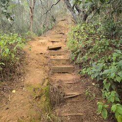
First...you need a permit to enter the military area. It is very simple to apply and receive a permit. The guards at the gate are very nice but will check your permit, license, registration and all. Please be respectful of the area and speed limits and off limit signs. There are two gates you need to go through to get to the trail. A MP needs to let you in and out of both. When you're ready to leave, you drive up to the first gate and call for the MP to meet you and then follow them to the next gate and out. The trail itself is very well maintained and there is a fair amount of tree cover as well. I have hiked two different trails back here. One we hiked the whole thing - to the fence and back, and we went the other way another but ran into a big off limit sign so we turned around. The other was more of a 4x4 driving trail that we walked. We set a time limit to head out and when we reached that time we were at a place that we could look out towards Mokuleia. It's very quiet and serene out here. Just you and nature. There are no trash cans that I have seen, so please take out what trash you make. Remember you are on military grounds - obey all posted signs for your safety.


The kuaokala trail is in Waianae and is absolutely worth the long trek. you do need a hiking permit to go through the military check point in the front of the hike and will be asked to present one! So get that ready. The parking lot is all dirt and was very muddy when we went as you can see from our pictures. Be sure to have a box or matt in the back of your car for dirty clothing and or shoes so you dont ruin your seats and floor. The trail is very shady and the views of the ocean are great. This hike is very empty also but still challenging!

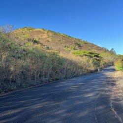
Moderate 5 mile R/T hike on the west side. You do need to get a vehicle pass through the website below (DLNR). There's a variety of terrain and it's mostly shaded. It can be a little steep and slick at times, so good shoes are important. Also, pay close attention to trail markers because it's easy to get lost up there. The views are BEAUTIFUL! This trail is part of the Na Ala Hele trail system. http://hawaiitrails.ehawaii.gov/trail.php?TrailID=OA+01+013&island=Oahu

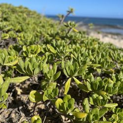
Went back and just did an out and back of the "nice" section of this hike from the parking lot to the rock overlooking Makua Valley. About 4 1/2 to 5 miles RT. Got misted upon but no real rain. Bummer as the clouds blocked the view of Makua Valley. Nice views of the ocean and Yokohama Bay Beach despite the clouds and light mist. Of course, by the time we finished the sun had come out! Nice shrooms along the trail. I love seeing wild shrooms; something I photographed each Fall in Europe for so many years before coming here.

8 months ago
This trail was absolutely beautiful in one of my favorite areas of Oahu. It had numerous shady areas which is a bonus. My favorite part was driving into Space Force Station and having amazing views while driving. You will have to obtain a pass through DLNR and show a valid ID at the gate as well as wait for an escort along the top of the mountain road. I had no issues with wait times. Keep hiking! read more


Hiked this trail for the first time, it is located past Makaha. You turn in at the Space force sign stopping at the guard shack. Must have identification for all hikers, car registration, safety doc. for car and print out of day pass permit acquired from trails.ehawaii.gov. Carry copy with you and one on dash of car. Once cleared you will drive up hill to gate where you will be escorted by Military Security to another gate to trailhead. The trail starts through very tall thick grass opening up to pine needle covered trail. In this section the trail can be a little narrow with a cliff drop off on one side. There are many gorgeous ocean and Mountain View's throughout most of the hike. The trail comes out on a dirt roads that can be steep as you climb higher. The trail becomes a single track again with area of loose dirt, steep areas and narrow with drop offs. You come up on rock formations that are shaped by erosion. This is a great area for pictures. Do not take your dog, there are signs by a gate warning you there may be hunting dogs and do not leave trail because there are snares to catch feral goats and pigs. We enjoyed this beautiful interesting hike. I'd start early as this hike can be warm in some areas. read more


For the Kuaokala Trail in Wai'anae, you will need to obtain a hiking permit from DLNR to enter through the military checkpoint and gates. The guards will check and verify your permit, license, etc. Always make sure you are complying with the speed limit. There is a designated dirt parking lot right after the second gate to get the trailhead itself. The trail is very quiet and shaded for the most part. You'll see great views of the Pacific Ocean, Wai'anae Valley, and perhaps even Mount Ka'ala on a clearer day. It can be easy to get confused or lost once you get past the rock-like sculptures and the first gate. Which is why I didn't go too much further past that point, however. read more


First...you need a permit to enter the military area. It is very simple to apply and receive a permit. The guards at the gate are very nice but will check your permit, license, registration and all. Please be respectful of the area and speed limits and off limit signs. There are two gates you need to go through to get to the trail. A MP needs to let you in and out of both. When you're ready to leave, you drive up to the first gate and call for the MP to meet you and then follow them to the next gate and out. The trail itself is very well maintained and there is a fair amount of tree cover as well. I have hiked two different trails back here. One we hiked the whole thing - to the fence and back, and we went the other way another but ran into a big off limit sign so we turned around. The other was more of a 4x4 driving trail that we walked. We set a time limit to head out and when we reached that time we were at a place that we could look out towards Mokuleia. It's very quiet and serene out here. Just you and nature. There are no trash cans that I have seen, so please take out what trash you make. Remember you are on military grounds - obey all posted signs for your safety. read more


6 years ago
The kuaokala trail is in Waianae and is absolutely worth the long trek. you do need a hiking permit to go through the military check point in the front of the hike and will be asked to present one! So get that ready. The parking lot is all dirt and was very muddy when we went as you can see from our pictures. Be sure to have a box or matt in the back of your car for dirty clothing and or shoes so you dont ruin your seats and floor. The trail is very shady and the views of the ocean are great. This hike is very empty also but still challenging! read more


11 years ago
Moderate 5 mile R/T hike on the west side. You do need to get a vehicle pass through the website below (DLNR). There's a variety of terrain and it's mostly shaded. It can be a little steep and slick at times, so good shoes are important. Also, pay close attention to trail markers because it's easy to get lost up there. The views are BEAUTIFUL! This trail is part of the Na Ala Hele trail system. http://hawaiitrails.ehawaii.gov/trail.php?TrailID=OA+01+013&island=Oahu read more


Went back and just did an out and back of the "nice" section of this hike from the parking lot to the rock overlooking Makua Valley. About 4 1/2 to 5 miles RT. Got misted upon but no real rain. Bummer as the clouds blocked the view of Makua Valley. Nice views of the ocean and Yokohama Bay Beach despite the clouds and light mist. Of course, by the time we finished the sun had come out! Nice shrooms along the trail. I love seeing wild shrooms; something I photographed each Fall in Europe for so many years before coming here. read more


11 years ago
You do need a permit to go on this hike. Went with a group so I'm not too sure how to get it. But this was an absolutely beautiful hike. Pretty easy, not too many hills and safe. Everything was so green which I have never seen down on the west side. The valleys, mountains, trees and ocean? All completely breathtaking. There are other trails that you can venture on and I would love to go back. read more


8 years ago
7 years ago
More info about Kuaokala Trail
Ask the Community - Kuaokala Trail
Review Highlights - Kuaokala Trail
You might also consider


Kuaokala Trail - hiking - Updated May 2026
Best of Waianae
People found Kuaokala Trail by searching for…
Hiking Trails in Waianae, Hawaii
Off Road Trails in Waianae, Hawaii
Things to Do in Waianae, Hawaii
Beautiful Views in Waianae, Hawaii
Walking Trails in Waianae, Hawaii
Scenic View in Waianae, Hawaii
Places to Take Pictures in Waianae, Hawaii
Running Trails in Waianae, Hawaii
Waterfall Hike in Waianae, Hawaii
Secret Spots in Waianae, Hawaii
Sunrise View in Waianae, Hawaii
Things to Do at Night in Waianae, Hawaii
Stroller Friendly Hikes in Waianae, Hawaii
View Points in Waianae, Hawaii
Parks for Kids in Waianae, Hawaii
Restaurants With a View in Waianae, Hawaii
Trending Searches in Waianae, HI
Boat Rental near Kuaokala Trail
Botanical Gardens near Kuaokala Trail
Bounce House Rentals near Kuaokala Trail
Campgrounds near Kuaokala Trail
Cherry Picking near Kuaokala Trail
Cliff Jumping near Kuaokala Trail
Dog Friendly Things To Do near Kuaokala Trail
Flower Fields near Kuaokala Trail
Flower Shop near Kuaokala Trail
Garage Sales near Kuaokala Trail
Lakes & Ponds near Kuaokala Trail
Nurseries & Gardening near Kuaokala Trail
Outdoor Activities near Kuaokala Trail
Outdoor Furniture Stores near Kuaokala Trail
Party Equipment Rentals near Kuaokala Trail
Pick Your Own Farms near Kuaokala Trail
Picnic Areas near Kuaokala Trail
Places To Take Pictures near Kuaokala Trail
Plant Nursery near Kuaokala Trail
Rock Quarry near Kuaokala Trail
Running Trails near Kuaokala Trail
Scenic Drive near Kuaokala Trail
Secret Spots near Kuaokala Trail
Strawberry Picking near Kuaokala Trail
Sunrise View near Kuaokala Trail
Swimming Holes near Kuaokala Trail
Browse Articles
Browse Nearby
Browse Brands
Related Searches in Waianae, HI
Affordable Kayak Rental Services in Waianae, Hawaii
Best Fishing Locations and Guides in Waianae, Hawaii
Best Nature Trails for Hiking in Waianae, Hawaii
Best Places for Horseback Riding in Waianae, Hawaii
Best Waterfalls and Swimming Holes in Waianae, Hawaii
Check Out Off Road Trails in Waianae, Hawaii
Discover Dog Friendly Trails to Explore in Waianae, Hawaii
Discover Scenic Hiking Trails in Waianae, Hawaii
Discover Scenic Waterfall Spots in Waianae, Hawaii
Discover Top Nature Parks to Visit in Waianae, Hawaii
Discover Walking Parks in Waianae, Hawaii Near You
Discover a Hiking Trail in Waianae, Hawaii
Discover the Best Night Hike Trails in Waianae, Hawaii
Enjoy Camping Adventures Around Waianae, Hawaii
Enjoy Exciting Mountain Biking Adventures in Waianae, Hawaii
Enjoy Kayaking Adventures in Waianae, Hawaii
Enjoy Tent Camping Spots Around Waianae, Hawaii
Enjoy Water Activities and Fun in Waianae, Hawaii
Enjoy a Beautiful Waterfall Hike in Waianae, Hawaii
Enjoy a Peaceful Nature Walk in Waianae, Hawaii
Enjoy the Best Picnic Spots and Ideas in Waianae, Hawaii
Enjoy the Best Walking Path in Waianae, Hawaii
Enjoy the Best Walking Trails in Waianae, Hawaii
Exciting Cliff Jumping Spots in Waianae, Hawaii
Explore Beautiful Parks and Green Spaces in Waianae, Hawaii
Explore Easy Hikes Perfect for All in Waianae, Hawaii
Explore Fun Activities to Do in Waianae, Hawaii
Explore Popular Campgrounds Near Waianae, Hawaii
Explore the Best Beach Spots in Waianae, Hawaii
Explore the Best Swimming Holes Around Waianae, Hawaii
Explore the Best Trail Options in Waianae, Hawaii
Family Friendly Hiking With Kids in Waianae, Hawaii
Find Popular Ziplining Spots Around Waianae, Hawaii
Find the Best Parks for Picnics in Waianae, Hawaii
Find the Best Scenic View Locations in Waianae, Hawaii
Great Places to Walk in Waianae, Hawaii
Hike the Popular Waterfall Trail in Waianae, Hawaii
Hiking Trails With Waterfalls in Waianae, Hawaii
Off Leash Dog Hiking Trails in Waianae, Hawaii
Plan a Scenic Drive Route Near Waianae, Hawaii
Popular Outdoor Activities to Try in Waianae, Hawaii
Popular Picnic Spots to Visit in Waianae, Hawaii
Safe and Fun Parks for Kids in Waianae, Hawaii
Top Climbing Spots and Gyms in Waianae, Hawaii
Top Paddleboarding Activities in Waianae, Hawaii
Top Places for Snorkeling in Waianae, Hawaii
Top Running Trails to Explore in Waianae, Hawaii
Top Swimming Spots and Pools in Waianae, Hawaii