Kealia Trail Photos


You might also consider
More like Kealia Trail
Recommended Reviews - Kealia Trail
Start your review...

Reviews With Photos - Kealia Trail
")
If you're looking for a 1 hour(ish) workout with a unique coastal airfield view, this is your place! This one is great because it's totally legal, dog friendly, has ample parking, and is half covered with shade. Expect to gain elevation quickly and to be hammered with switchbacks galore. My little one (a shih tzu-Maltese-chihuahua mix) couldn't even make it halfway up the last time, but she was more than determined to make it the second time around... and SHE DID. So proud!! I used to hate this hike, but now, I think it's a pretty decent one! This one affords unique views of Dillingham Airfield and Moke's that you wouldn't see otherwise. Just remember to bring water, snacks, and to start early because can get really hot.

I absolutely love this trail! It has got to be one of my top fav's now. Not stroller friendly but hubby carried my 10month old in our ergo backpack up and down like a champ! Not one huff or puff. Kealia Trail is a nice and what seemed like a well maintained path. It's not paved, yet it isn't difficult to maneuver through for the most part until you get to the part where there are a ton of switchbacks and at times your climbing up about 1 foot rocks. I had planned to count the switchbacks on my way down but what had happened was.... We decided to do a sunset hike (5:30pm, sunsets at 7:11 more than enough time) soon to learn that right when we're about 10mins away from the picnic table, other hikers warn that the guy will close the gates at 7pm sharp. It was 6:35pm.......There was only 2 options, fight til the finish, or flight (book it fast) back down the trail and plan for another day. You bet your bottoms, I sprinted to the top and made it back down by 7pm. Back down to the start of the trail that is. I was huffing and puffing.l and I didn't even reach the lot yet. With a team effort, one of us who chose the flight option and was smart to drive her car to the gate in case the guy were to lock us in. Rest assured, that last boost of adrenaline kicked in and we finally made it to our cars and out the gate with no sign of the dude. But we seen him past us as we were driving past the airfield. All in all, it was a beautiful hike and I'd do it more often. Nice parking lot although stinkin google maps almost took me literally through the airfield. Stay on the main road and take the left right after you've reached the end of the airfield. Follow the road a bit and park in the designated Kealia Trail parking lot.

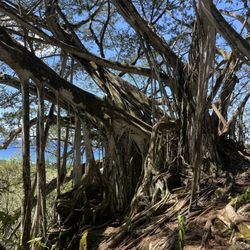
After looking at so many trails online, it was hard to find one that wasn't in the back of a town in someone's back yard and trespassing. Kealia is one that you don't have to worry about in terms of parking and/or feeling like you're getting stink eyes from the neighbors or even feeling like you're walking into something shady. P A R K I N G The parking is located on an airfield but it's legal and so many cars were there when we left and when we arrived. H I K E The hike starts right across the parking lot. At first it's flat before you suddenly hit the mountain and it's pretty much switchbacks until you get to the "bench." The trail itself has a lot of greenery that can brush your legs. It gets muddy and the rocks are slippery and steep at moments. So take your time going up and down as you don't want to hurt yourself. I would not go here on a rainy day. It'd be a very long & slow hike to be really safe. I slipped a couple times and I had trail runners on and it was just a day after raining. What's pretty great was we came in the mid afternoon and we were in the shade the whole time. So although it was warm, we had the breeze and shade to keep us cool. It took us about 75 minutes up and down but we did stop at the bench. You can keep going up to complete the 3-4 mile trek up and then come back down. But if you want to keep it to just a total of 3 miles then just get to the bench...take a little breather in the wide clearing there (there's no real views at that point) and then come back down and find the little ridge with the actual views a little ways down. Also what was great was there wasn't a whole lot of people (unlike Diamond Head). The trails are pretty much enough room for 1 person so be kind and considerate for people passing or if you're going slower then step aside. I saw a lot of guys running up the mountain and I think they were training for something. You could take a short cut to the bench by climbing up the side of the mountain (which a couple of those guys did) at the point where there's a view. But be safe! If you're not a seasoned climber or don't have the right gear, just suck it up and do the switchbacks. O V E R A L L A lovely hike that I would in a heartbeat do again and hopefully if we had more time next time, go all the way to the top....of course only if it's not raining!

This is my absolute favorite hike! It is uphill and parts are steep but it seems less crowded and less tourist polluted than the more popular trails around the island. Most of the trail is shaded by trees but ever now and then you'll have the privilege of seeing nothshore's landscape at certain points. Sometimes you can even witness paragliding taking place in the distance. I think this is a great place for a romantic hike and picnic or fast paced uphill trekking for the average person who can handle light exercise. My cell phone did not get reception mostly (which is awesome if you are in the mode to detach/unplug for a while). I've taken my friends, work associates, and other people close to me for years. There is plenty space to park near the airstrip. If you want to get the most out of it, try showing up around 05-0530 on the weekend. Bring snacks and food so you won't have to rush! Mostly the picnic table is free when I go. Make sure you take it all in.
")
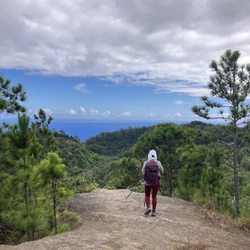
If you're looking for a moderate trail about 7 miles long, pretty safe, and mostly tree covered, the Kealia Trail is the one for you! You park and start off right behind Dillingham Airfield, then you hike the first 45 to 55 minutes (depends on how fast you walk) up the switchbacks, enjoy the nice view of the airstrip and beaches, up to the picnic table right at the top of the mountainside. A really nice place to rest in the pine trees and usually got a nice breeze. Then if you feel energetic, you just continue hiking up the dirt roads uphill ... some at pretty steep grades, and about another hour, you reach the top where it overlooks the Waianae coast! I really like this trail 'cuz like I mentioned, it does have a lot of trees. If you start around 800 - 830 am ish, probably will take you about 3 hours (relatively fast hiker in decent shape) to about 3 1/2 to 3 hours 50 minutes (slower hiker), and you have shade! But be sure to take water with you! Also having a walking stick really does help with the uneven rocky and sometimes muddy surfaces especially if it rained the night before. I've never continued past that gate at the top, but there are other trails that people hike around the top, or continue down the other side. Maybe one day I'll do that, but my old legs does have its limitations! If you're not in shape, your legs will punish you the next day ... and the day after that! he he! (going down stairs will be FUN!) But don't let that deter you, this is one of my favorite hike where I can get a 3 hour workout in the countryside!

Nice hiking trail on the far end of the west side near Mokuleia & Dillingham Airfield. Not a lot people on this trail which is good. A bit challenging, noticed a lot of switchbacks and a little bit of rock climbing (no ropes needed though.) Nice views along the way to the top. We stopped at the shaded bench area and turned around to head back down. Much easier going back down then going up that's for sure! Took us about an hour going up and 40 minutes heading back down. Trail is mostly shaded with lots of trees. I would definitely do this hike again with friends. It's a great hike for cardio!

This trail is well marked up to the gazebo, 1.3 miles. The trail starts off wide and clear with no obstacles. 1/3 up you will hit several switch backs with rocks to step on and over. Some rocks are a foot high to step on to. This trail is also popular with mountain bikers (MTB). They normally ride down this trail with body armor and a good dual suspension MTB. They start on Mokuleia Access Rd in Waialua. The trail manners for MTB's is to give way to hikers. I was taught this when I first started riding MTB in 2012. Once at the gazebo it over looks the Pacific Ocean. You can continue on for 3 more miles to the fire road to view Makua Valley in Waianae. Also if the view is clear you can see the AirForce white ball on Mt Ka'ala, the highest peak on O'ahu. There are trail signs, but it can confuse you when you come to a fork in the fire road. I took several photos indicating the direction. The last photo just before you hit the gate has a finger pointing the direction to go. Total round trip miles is 8. I brought 4 liters of icy cold performance fluids and my bento. :-)

I always love this trail due to the condition of the trails and good cardio challenge. I would classify this trail intermediate especially if you are going all the way to the top which is almost another two miles from the shelter. Today was a perfect day for this hike with overcast and even misty conditions. I do not advise this trail for summer midday or afternoons as the first part of this hike is the switchback trails alongside the mountain, not covered with trees. The second part is a shaded roadway and pretty much all uphill. Great views of the shoreline on the first part of the hike.

Kealia Trail is located at the end of Dillingham airfield where they do sky diving activities. This trail is on the hot and dry side. The official trail website says it's 7 miles trip. Unfortunately, my clan couldn't accomplish this trail mainly because of me. I'm more of wet and cool hiker than hot and dry. Regardless, I enjoy the crowd here giving us positive motivation like we're almost there on our 1 mile up. Yeah right! These hikers were more on the serious yet nice. To me, every trail has its own personality. Anyhow, we did 2 miles up and gave up. Maybe we should have come earlier and not at 12 pm. Parking is plentiful and there's bathroom at the end of airplane warehouse which was clean and convenient.


Kealia trail starts in the parking lot of Dillingham airfield to the right when you are driving in. There are tons of parking spots in the parking to the left so parking has never been an issue for me. There are many signs and pink ribbons on the trail to make sure you are on the right path although the trail itself is very paved. There are a ton of switchbacks to start with beautiful views of mokuleia's makai views. Be sure to enjoy the views on the way up. It took me 28 minutes to get to the top where there is a picnic table where you can relax and enjoy. Most people I speak to stop there and turn around. If you decide to continue on, which I usually do the trail becomes less populated. If you decide to continue, you'll have options of different trails which are displayed by trail heads and signs. I personally continue initially to the left where I enter two different gates that I have to open and close. The view turns into more of a valley as you are facing mauka side. If I had all day I would continue down the ridge which would kick me out to the Farrington area I imagine. Time: 1-1.5 hours from the bottom to picnic table and back. Solo for me 2.5-3 hours solo walking with a semi fast pace (3-4 hours casual walking). Difficulty: Moderate: You'll get a semi appreciable lower body workout but not as much cardiovascular workout as other steeper hikes. Enjoy!


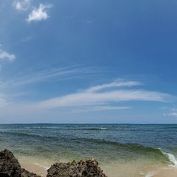
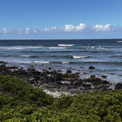
This hike is what I would call easy to medium. If you're in good shape, it will be easy, if you're like me and you're "on my way to a shape that is not a circle" you'll find this hike challenging. The best thing about this hike for me is that there is no "fear of death". You always have the mountain on one side of you and the trail is wide enough and well maintained so you can always see where you're placing your feet. You may have heard that it is a trail of 19 switchbacks. I can't confirm the number because I don't count them as I go up or down, but yes - it is all switchbacks. But I prefer switchbacks sometimes because the incline is not as great and the turns offer you a chance to rest on the side if there are a lot of people on the trail and you don't want to feel rushed. There is one section of the trail that is my favorite!!! You are about midway up and there's a break in the trees and you can see the coast below you. It is such a pretty sight!! The waves coming in and breaking on the shore, the airfield where pilots are prepping to go up or landing, the military training area and more!!! This trail does get HOT. I think the rocks absorb the heat and then just emits all that hotness as the day goes on. I recommend you start early so that you're up at the pavilion before noon, going down in the heat is much better than going up. I have done this trail three times (forgot to check in once) and I started at 5 am, 6 am and 8 am. Any one of those times are good start times. The time I started at 5 am we went all the way up to the top to the beginning of the Kuaokala Public Hunting Area. I recommend you bring: Water - at least 2 liters Sunscreen - while parts of the hike is shaded, there are times you will be in the sun Hat - for the reason above Hiking shoes - trail running shoes are good as well. There are a lot of rocks, so something with a little more grip is better for this trail. Phone/camera Snack - at the "pavilion" you can take a seat and rest while eating. Hope you enjoy this hike as much as I do!!!

Nice little trail on the north shore. You park at the dillingham airport and the trailhead is across the street. Not hard to find. The first half mile is shaded switchbacks. The mile after that is exposed. It sort of reminded me of hikes in SoCal. The gradient isn't too bad because of the switchbacks but you are going up about 1000' in like 1.5 miles. So the climbing can feel a bit relentless. No scrambling over rocks and other obstacles like some other Oahu hikes. I thought it was fairly easy. I think anyone in decent shape won't have any issues. For those who are just beginning your fitness journey, this would probably be a good workout. The trail is easy to follow. Very little chance of you getting lost (at least to the picnic table which was my turn around point). It's very rocky but walking/hiking isn't an issue. Trail Runners: I saw some other trail runners but this wouldn't be my first choice trail on the north shore. The switch backs don't go on long enough to get any sort of rhythm after the half mile point. And while I wouldn't say this is the most technical of runs, you definitely have to pay attention. I went super slow on the decent for my first time. I may go back and go past the picnic table to see what's up there but I'd say skip this if you're a runner. Hikers will like it I think. And it wasn't too crowded. I saw a handful of people on my run. The views are ok. There are definitely much more scenic views on Oahu but these weren't bad by any means. read more


We decided to challenge ourselves and hike to the summit. We were paid back with beautiful views of the Makaha Valley on the other side of the island and sore joints. The first 1.7 miles we made our way up rocky lava rock stair step zig zag trail up the mountain side. In this section there is shade in the morning. Although after 12 it was more exposed as we came back down. There is one area you have to maneuver around a huge boulder that fell on the trail. Once you make it to the picnic table the trail turns into more of a hard packed fire trail. As you ascend there is a little more breeze and shaded. The fire roads are steep in places and long uphill treks. So prepare to get a good workout. We saw only one person on this section of the trail and felt we were truly out in nature. There was a variety of different kinds of trees and plants along the way which was leading us to the summit. We were hoping it would all be worth it. We went through the gate onto a different trail for the best view of Makaha Valley on the Leeward side of island. And it was well worth it. Descending went quickly, accept once we entered the rocking zigzag trail which required careful foot placement at times. Poles helped a lot in this section. Even though we started early, with the trail taking more than 4 hours it was growing warm and humid. Be prepared with plenty of water, snacks, poles, bug spray, sunscreen and hat. We also use Alltrails so there is no doubt on the direction to hike once you get to dirt road section. The trail is also longer than what is indicated on Alltrails. Parking is easy to find at airport, there is a sign also pointing out trail parking. read more


1 year ago
4 years ago
If you're looking for a 1 hour(ish) workout with a unique coastal airfield view, this is your place! This one is great because it's totally legal, dog friendly, has ample parking, and is half covered with shade. Expect to gain elevation quickly and to be hammered with switchbacks galore. My little one (a shih tzu-Maltese-chihuahua mix) couldn't even make it halfway up the last time, but she was more than determined to make it the second time around... and SHE DID. So proud!! I used to hate this hike, but now, I think it's a pretty decent one! This one affords unique views of Dillingham Airfield and Moke's that you wouldn't see otherwise. Just remember to bring water, snacks, and to start early because can get really hot. read more
 - Hiking Near Me")


 - Hiking Near Me")


I absolutely love this trail! It has got to be one of my top fav's now. Not stroller friendly but hubby carried my 10month old in our ergo backpack up and down like a champ! Not one huff or puff. Kealia Trail is a nice and what seemed like a well maintained path. It's not paved, yet it isn't difficult to maneuver through for the most part until you get to the part where there are a ton of switchbacks and at times your climbing up about 1 foot rocks. I had planned to count the switchbacks on my way down but what had happened was.... We decided to do a sunset hike (5:30pm, sunsets at 7:11 more than enough time) soon to learn that right when we're about 10mins away from the picnic table, other hikers warn that the guy will close the gates at 7pm sharp. It was 6:35pm.......There was only 2 options, fight til the finish, or flight (book it fast) back down the trail and plan for another day. You bet your bottoms, I sprinted to the top and made it back down by 7pm. Back down to the start of the trail that is. I was huffing and puffing.l and I didn't even reach the lot yet. With a team effort, one of us who chose the flight option and was smart to drive her car to the gate in case the guy were to lock us in. Rest assured, that last boost of adrenaline kicked in and we finally made it to our cars and out the gate with no sign of the dude. But we seen him past us as we were driving past the airfield. All in all, it was a beautiful hike and I'd do it more often. Nice parking lot although stinkin google maps almost took me literally through the airfield. Stay on the main road and take the left right after you've reached the end of the airfield. Follow the road a bit and park in the designated Kealia Trail parking lot. read more


7 years ago
After looking at so many trails online, it was hard to find one that wasn't in the back of a town in someone's back yard and trespassing. Kealia is one that you don't have to worry about in terms of parking and/or feeling like you're getting stink eyes from the neighbors or even feeling like you're walking into something shady. P A R K I N G The parking is located on an airfield but it's legal and so many cars were there when we left and when we arrived. H I K E The hike starts right across the parking lot. At first it's flat before you suddenly hit the mountain and it's pretty much switchbacks until you get to the "bench." The trail itself has a lot of greenery that can brush your legs. It gets muddy and the rocks are slippery and steep at moments. So take your time going up and down as you don't want to hurt yourself. I would not go here on a rainy day. It'd be a very long & slow hike to be really safe. I slipped a couple times and I had trail runners on and it was just a day after raining. What's pretty great was we came in the mid afternoon and we were in the shade the whole time. So although it was warm, we had the breeze and shade to keep us cool. It took us about 75 minutes up and down but we did stop at the bench. You can keep going up to complete the 3-4 mile trek up and then come back down. But if you want to keep it to just a total of 3 miles then just get to the bench...take a little breather in the wide clearing there (there's no real views at that point) and then come back down and find the little ridge with the actual views a little ways down. Also what was great was there wasn't a whole lot of people (unlike Diamond Head). The trails are pretty much enough room for 1 person so be kind and considerate for people passing or if you're going slower then step aside. I saw a lot of guys running up the mountain and I think they were training for something. You could take a short cut to the bench by climbing up the side of the mountain (which a couple of those guys did) at the point where there's a view. But be safe! If you're not a seasoned climber or don't have the right gear, just suck it up and do the switchbacks. O V E R A L L A lovely hike that I would in a heartbeat do again and hopefully if we had more time next time, go all the way to the top....of course only if it's not raining! read more


This is my absolute favorite hike! It is uphill and parts are steep but it seems less crowded and less tourist polluted than the more popular trails around the island. Most of the trail is shaded by trees but ever now and then you'll have the privilege of seeing nothshore's landscape at certain points. Sometimes you can even witness paragliding taking place in the distance. I think this is a great place for a romantic hike and picnic or fast paced uphill trekking for the average person who can handle light exercise. My cell phone did not get reception mostly (which is awesome if you are in the mode to detach/unplug for a while). I've taken my friends, work associates, and other people close to me for years. There is plenty space to park near the airstrip. If you want to get the most out of it, try showing up around 05-0530 on the weekend. Bring snacks and food so you won't have to rush! Mostly the picnic table is free when I go. Make sure you take it all in. read more


If you're looking for a moderate trail about 7 miles long, pretty safe, and mostly tree covered, the Kealia Trail is the one for you! You park and start off right behind Dillingham Airfield, then you hike the first 45 to 55 minutes (depends on how fast you walk) up the switchbacks, enjoy the nice view of the airstrip and beaches, up to the picnic table right at the top of the mountainside. A really nice place to rest in the pine trees and usually got a nice breeze. Then if you feel energetic, you just continue hiking up the dirt roads uphill ... some at pretty steep grades, and about another hour, you reach the top where it overlooks the Waianae coast! I really like this trail 'cuz like I mentioned, it does have a lot of trees. If you start around 800 - 830 am ish, probably will take you about 3 hours (relatively fast hiker in decent shape) to about 3 1/2 to 3 hours 50 minutes (slower hiker), and you have shade! But be sure to take water with you! Also having a walking stick really does help with the uneven rocky and sometimes muddy surfaces especially if it rained the night before. I've never continued past that gate at the top, but there are other trails that people hike around the top, or continue down the other side. Maybe one day I'll do that, but my old legs does have its limitations! If you're not in shape, your legs will punish you the next day ... and the day after that! he he! (going down stairs will be FUN!) But don't let that deter you, this is one of my favorite hike where I can get a 3 hour workout in the countryside! read more
 - Hiking Near Me")


Nice hiking trail on the far end of the west side near Mokuleia & Dillingham Airfield. Not a lot people on this trail which is good. A bit challenging, noticed a lot of switchbacks and a little bit of rock climbing (no ropes needed though.) Nice views along the way to the top. We stopped at the shaded bench area and turned around to head back down. Much easier going back down then going up that's for sure! Took us about an hour going up and 40 minutes heading back down. Trail is mostly shaded with lots of trees. I would definitely do this hike again with friends. It's a great hike for cardio! read more


This trail is well marked up to the gazebo, 1.3 miles. The trail starts off wide and clear with no obstacles. 1/3 up you will hit several switch backs with rocks to step on and over. Some rocks are a foot high to step on to. This trail is also popular with mountain bikers (MTB). They normally ride down this trail with body armor and a good dual suspension MTB. They start on Mokuleia Access Rd in Waialua. The trail manners for MTB's is to give way to hikers. I was taught this when I first started riding MTB in 2012. Once at the gazebo it over looks the Pacific Ocean. You can continue on for 3 more miles to the fire road to view Makua Valley in Waianae. Also if the view is clear you can see the AirForce white ball on Mt Ka'ala, the highest peak on O'ahu. There are trail signs, but it can confuse you when you come to a fork in the fire road. I took several photos indicating the direction. The last photo just before you hit the gate has a finger pointing the direction to go. Total round trip miles is 8. I brought 4 liters of icy cold performance fluids and my bento. :-) read more


I always love this trail due to the condition of the trails and good cardio challenge. I would classify this trail intermediate especially if you are going all the way to the top which is almost another two miles from the shelter. Today was a perfect day for this hike with overcast and even misty conditions. I do not advise this trail for summer midday or afternoons as the first part of this hike is the switchback trails alongside the mountain, not covered with trees. The second part is a shaded roadway and pretty much all uphill. Great views of the shoreline on the first part of the hike. read more


Kealia Trail is located at the end of Dillingham airfield where they do sky diving activities. This trail is on the hot and dry side. The official trail website says it's 7 miles trip. Unfortunately, my clan couldn't accomplish this trail mainly because of me. I'm more of wet and cool hiker than hot and dry. Regardless, I enjoy the crowd here giving us positive motivation like we're almost there on our 1 mile up. Yeah right! These hikers were more on the serious yet nice. To me, every trail has its own personality. Anyhow, we did 2 miles up and gave up. Maybe we should have come earlier and not at 12 pm. Parking is plentiful and there's bathroom at the end of airplane warehouse which was clean and convenient. read more

6 years ago
This is a great trail to hit on Oahu. It is a moderate to easy trail. It also has some great views. I'd do it again when visiting Oahu. read more

8 years ago
8 years ago
Kealia trail starts in the parking lot of Dillingham airfield to the right when you are driving in. There are tons of parking spots in the parking to the left so parking has never been an issue for me. There are many signs and pink ribbons on the trail to make sure you are on the right path although the trail itself is very paved. There are a ton of switchbacks to start with beautiful views of mokuleia's makai views. Be sure to enjoy the views on the way up. It took me 28 minutes to get to the top where there is a picnic table where you can relax and enjoy. Most people I speak to stop there and turn around. If you decide to continue on, which I usually do the trail becomes less populated. If you decide to continue, you'll have options of different trails which are displayed by trail heads and signs. I personally continue initially to the left where I enter two different gates that I have to open and close. The view turns into more of a valley as you are facing mauka side. If I had all day I would continue down the ridge which would kick me out to the Farrington area I imagine. Time: 1-1.5 hours from the bottom to picnic table and back. Solo for me 2.5-3 hours solo walking with a semi fast pace (3-4 hours casual walking). Difficulty: Moderate: You'll get a semi appreciable lower body workout but not as much cardiovascular workout as other steeper hikes. Enjoy! read more


If you ever on the North Shore side of Hawaii and wanna go for a nice hike? I'd suggest you to come here but you need to be a little bit athletic and quick on your feet. Come here at your own risk and just please be safe! read more

This hike is what I would call easy to medium. If you're in good shape, it will be easy, if you're like me and you're "on my way to a shape that is not a circle" you'll find this hike challenging. The best thing about this hike for me is that there is no "fear of death". You always have the mountain on one side of you and the trail is wide enough and well maintained so you can always see where you're placing your feet. You may have heard that it is a trail of 19 switchbacks. I can't confirm the number because I don't count them as I go up or down, but yes - it is all switchbacks. But I prefer switchbacks sometimes because the incline is not as great and the turns offer you a chance to rest on the side if there are a lot of people on the trail and you don't want to feel rushed. There is one section of the trail that is my favorite!!! You are about midway up and there's a break in the trees and you can see the coast below you. It is such a pretty sight!! The waves coming in and breaking on the shore, the airfield where pilots are prepping to go up or landing, the military training area and more!!! This trail does get HOT. I think the rocks absorb the heat and then just emits all that hotness as the day goes on. I recommend you start early so that you're up at the pavilion before noon, going down in the heat is much better than going up. I have done this trail three times (forgot to check in once) and I started at 5 am, 6 am and 8 am. Any one of those times are good start times. The time I started at 5 am we went all the way up to the top to the beginning of the Kuaokala Public Hunting Area. I recommend you bring: Water - at least 2 liters Sunscreen - while parts of the hike is shaded, there are times you will be in the sun Hat - for the reason above Hiking shoes - trail running shoes are good as well. There are a lot of rocks, so something with a little more grip is better for this trail. Phone/camera Snack - at the "pavilion" you can take a seat and rest while eating. Hope you enjoy this hike as much as I do!!! read more


9 years ago
Pretty decent trail with beautiful views of the North Shore. We came with our 3 year old and it was do-able, except we stopped around 5 miles and did not finish the full length of the trail. Most of the trail was rocky ( small and big rocks), narrow, and had some steep climbs. I wouldn't exactly say it is family friendly for families with toddlers. I'd say recommended age is 5 and up. read more

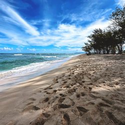
Endure the blazing hot rocky trail and 19 switchbacks, through the breeze-less and hilly (but wide and easy to navigate) trail up to the Makua valley lookout and you are rewarded with a sight very few see - a remote and undeveloped lush green valley and breathtaking mountain cliffs along the back of the Waianae mountain range. http://www.yelp.com/biz_photos/kealia-trail-mokuleia?select=WbBU41rMD9V8ov2V3odgnQ#43cFmO_jWaQHRZWtlU4eqA Thank goodness for Yuko's review noting the number of swtichbacks, counting them made for a great distraction while willing ourselves up and down the rocky, dusty and un-shaded portion up the mountain. http://www.yelp.com/biz_photos/kealia-trail-mokuleia?select=WbBU41rMD9V8ov2V3odgnQ#1q2a82T92XmE5JmR5PxHWQ It was also handy when encountering a couple of young military guys headed up, (one barefoot ?! and looked pretty miserable) we were able to answer their plea - "are we almost there?!" with "7 more switchbacks to go buddy!" http://www.yelp.com/biz_photos/kealia-trail-mokuleia?select=WbBU41rMD9V8ov2V3odgnQ#cgEd3TmfhSuGNG70iiqRZA Note to everyone - unless you have feet made of steel, don't go barefoot, wear shoes with great soles, you'll enjoy this so much more! Bring LOTS of water. We finished my 3 liter bladder with no problem on our 3 hour venture up and down. After the hike, head straight to the beach and jump in the beautiful water to cool off! Directions: enter the Dillingham airfield a the West gate (last gate, there is a sign warning of low flying aircraft at the entrance), turn left to go on the back side of the airfield and park in the lot in front of the air control tower. The trailhead is across the road from the parking lot. http://www.yelp.com/biz_photos/kealia-trail-mokuleia?select=WbBU41rMD9V8ov2V3odgnQ#hPcZpzxF0Mkpfv60YF4QCw read more

 - Hiking Near Me")


14 years ago
This hike is located behind the Dillingham Airfield (north/east part of Oahu). Pet friendly (with motivation of another dog) hike. I've seen kids hike this trail as well. Wear proper hiking shoes and tennis shoes. I would highly recommend bringing a snack or lunch and lots of water. I hiked this trail for the first time with my 5 year old beagle. The hike was a bit challenging due to the rocks. It was definitely challenging for me because I am short and practically had to climb some of the high steps and big rocks. Otherwise this hike was great all the way to the top and it's nothing but an incline type of hike with nice views. When hiking with a group, we had to hike in single file and took caution with every step with the rocks. You can easily slip and break your ankle. There are some steep steps and no shades. This can be a very hot hike on the way up. Also, if you decide to take the challenge, make sure to look at the weather forecast. I hiked down this trail during the rain and it got real muddy, slippery and dangerous. When you reach the top, there are picnic tables you can eat your lunch. Over all it was a great experience and I recommend trying the hike. At least one time. Rating this hike for experienced hikers and semi-experienced. I would recommend hiking it with someone that already hike it for your first try. read more


13 years ago
Between 3 & 4 stars. On a scale of 1 to 10 for difficulty: 7 because it's a relentless climb of continuous switch backs that have some uneven (rocky) portions. Think "Diamond Head" x 10 where it continually switches back & forth and the terrain is uneven. Relatively easy to find on Oahu's North Shore. Lots of parking. You feel safe leaving your car. As with most hikes in Hawaii that are not "approved", you'll see numerous signs saying "No Trespassing" and "Keep Out" until you actually start the climb. I find it ironic that you have a sign saying "Kealia Trail" right next to the "Keep Out" signs. As you can see from others who have posted pics, the view can be stunning...on a clear day. Ours was overcast and very muggy. Therefore this hike for us had little to offer in the "Ooo-aaaah" sights to behold. We actually had two in our group of five turn around about 3/4 of the way up. All factors considered, they were getting over heated, the views were less than spectacular, they came to the conclusion this was no longer "fun" and opted to head back down to the car. No judgement. It's vacation and to each their own. The trail was also pretty active with several users. We happened to coincide our hike with some "suicide" race where runners were timed on a double loop. So there were several moments of stepping to the side while a sweat streaked, mud caked glutton for pain huffed by. I won't dock a star for those racers, it was just coincidence. In truth, we have a lot of respect for them. More power to ya! Woo-hoo! Whoop whoop whoop! Still, this trail appears to be very popular with the locals and military as a workout. It's definitely well used. If you are looking for a peaceful, serene hike without seeing another soul, this is probably not the one for you. Caveat: past the picnic table, where most people turn back, it might get very remote with other hikers few and far between....but I'm just speculating here. We'd do this hike again, but would rather wait for a clear day! read more
 but as others have noted, the \"trail\" continues on for miles. We opted to head back from here. - Hiking Near Me")
This is an excellent hike for those who are dog lovers and want a moderate workout with good views :) The trail is very dog friendly for those with athletic dogs and can be a workout or a nice morning stroll, depending on the pace you take it at! Best part about it is that it is mostly shaded so you wont end up covered in sweat and your dog won't have their tongue out the whole time! Tips: - Bring more water than you think you will need! (Especially if you go with your dog!) - Lock your car (the parking lot is in Dilliingham Airfield and although it is safer than many other parking spots in N shore, there are break-ins) - When you reach the picnic table, it looks like the hike is pau but you can continue up if you want to keep going! - Watch your footing- it is a rocky trail! (I wouldn't recommend vibram "toe" shoes for this trail!) - Take pictures and stop to enjoy the view! (The views as you go up are best... the top is shaded) - Go with a buddy (Hiking alone is never the smartest decision, plus, who would you admire the scenery with?!) read more


Don't let the crybabies scare you!!! They'll cry about the heat. Go early and on a day when there's good tradewinds and low humidity. They'll cry about the difficult 19 switchbacks. 19 switchbacks is much better than climbing up one steep arse hill. Plus they're relatively short and offer breathtaking views of the North Shore. These amazing views continue for almost an hour until you reach a shaded picnic table. Most people stop here, but we continued on in search of the viewpoint for Makua Valley. After the picnic table, you pretty much lose those amazing North Shore views and wish you had those 19 switchbacks. You'll pass an old water tank with graffiti art and beautiful eucalyptus trees as you climb up a series of steep dirt hills that seem to go on forever. We got so caught up on trying master these hills we missed our turn onto Kuaokala Trail for Makua Valley viewpoint. [Insert slap on the forehead and scream here] No worries...the ease of this trail and amazing views makes me want to hike it over and over and over. Stay tuned for pictures of Makua Valley! read more


A easy intermediate hike by Dillingham Airfield (end of the road where you turn to go skidiving) which was very peaceful with beautiful views of the ocean along the way. There are 19 switchbacks to the top. I do not advise wearing Vibrams, since the trail is scattered with big and small rocks some of which you have to climb atop of. For us I think it was actually harder coming down because of the Vibrams. Moving on, after getting to the bench we kept going up the road. And let me tell you, the road goes on and on and on. I've actually heard 15 miles till the end? Anyway, we kept going up and up and up till we got to the Kuaokala trail and walked for an hour or so and then came back. Unfortunately there were no good look points on the trails we were on because the trees were blocking the view. Nonetheless, it was refreshing to hike another mountain range on a completely different part of the island. I'd like to explore the other side of the range next time because I'm sure the view of the West Side is pretty amazing. YELP 365: 114/365 read more


12 years ago
This hike is near the dilingham airfield. Enter the WEST gate, drive down the road until you see a parking lot to your left. You can park there, and the trial head begins right across the parking lot. Most of this hike is an incline, so you will definitely get in a leg and cardio work out. But there are lots of pockets of shades to stop and rest at if needed. We stopped once we got to the benches. The view throughout the hike is absolutely breath-taking but once you reach the benches the view is blocked by those weird trees you find all over bellows beach. It took us an hour up and 45 minutes down. You can definitely continue the hike after the benches, but I can't speak on what's there or how far it is until you hit the summit. read more


11 years ago
10 years ago
I have been bringing my kids here since I was carrying them in the bjorn. Now my 5 year old can complete it on her own :) It's a beautiful, safe, well maintained trail that goes up the Waianae Mountain range with ocean views (we watched whales while we hiked in January, which was amazing!) At the top (about one mile up) These is a picnic table and shade. If you continue hiking up the mountain, you will eventually end up looking over Waianae. Be sure to keep hiking to the right, because I took a wrong turn and ended up hiking an extra 30 minutes. Always go right! The hike after the picnic table is a lot of up hill and mostly on a dirt road. Again I repeat, stay right! read more


This hike is awesome if you want great views of gliders taking off, small planes landing, and the north shore waves. I found this hike from yelp and wanted a hike that was differently and new. Very few people come out to Dillingham airfield because they usually head East after arriving at Haleiwa and go towards Kahuku. However, this is about a 10 minute drive from Haleiwa and the hike parking lot is the last lot on your left hand side at Dillingham airfield. The walk to from parking to trailhead is about 10 minutes and you can either follow the driveway that says "restricted" (not really) or the shaded path to the right that parallels the driveway. Once you see the sign for the start of the trail, you will have about 30 minutes of shaded uphill climb. Afterwards, when the shade is gone, you will have another 30-45 min of uphill switchbacks until the peak. After the peak, you will turn inland and see some dirt roads, about 15 minutes more uphill the dirt roads you will read a shaded picnic area. After the picnic area, the Kealia trail splits into 2 different trails and I turned back afterwards because the views pretty much disappeared after the picnic tables. This is an immediate level Hike, very sunny (have sun block and a hat), can be HOT (bring lots of water, I finished my 2L water bag within the hike), and food for the picnic table at the top. Note, it is pretty much completely uphill the entire way up for 1 hour, but then the way back is much much faster! read more


11 years ago
There are 19 switchback turns on the hike, so use this as motivation to push through! It is 1.3 miles up, but there is a picnic table and lots of shade at the top! This hike, though the terrain can be annoying at times, is definitely one that everyone who likes to hike and lives in Hawaii should do at least once in their life. The view of Makua Valley, the ocean, and the research facility lake is breathtaking so don't forget your camera (or your phone if your smart phone is from this generation)!! Because it was very rainy last week (thanks Himenes), the grass and leaves were very overgrown in some parts. The heat is very intense when you get higher up, as there is no trees offering shade. So bring sunscreen! read more


15 years ago
This hike is a great hike. At the beginning it didn't seem to steep, but it definitely became more steep. Though some areas are worst than others in terms of steepness. It wasn't all that technical which was nice. It is a well maintained trail and easy to follow. Lots and lots and lots, oh did I mention - lots of switchbacks. Lots. It is a good workout. You have a wonderful view of the ocean most of the entire hike up. At the top there is a picnic table - awesome spot for a mid hike picnic before heading up further or turning around. That is what we did. This was our Christmas 2011 hike, and we packed a picnic, stopped at this point and enjoyed the food and a glass of wine. We then kept going up what looked like a dirt road. This is where it gets really steep. We kept thinking "one more hill, only one more" but it always seemed to be significantly more then one more. It appears that this dirt road could go on for QUITE a while. We ended up turning around after being on the dirt road for about a mile. In total our hike was a 5 mile hike. It took about 2 and a half hours. Great hike. Well maintained. Good work out. Excellent view. Good food (if you bring a picnic, like we did). What else could I have asked for? Nothing. Go and hike it! read more


My friends have been running this trail for years. Since I'm mostly a road runner I've never joined them. But last weekend I came here for the first time with my friends (and my dog). There is a parking lot and 2 bathrooms that are pretty clean. I recommend bringing water and a snack. We started around 7am and it is about 3 miles round trip to the picnic bench and back. Beautiful views up the switchbacks to the top and the trees give just enough cover to keep things cool. I loved the fact that it wasn't that crowded. I will definitely be back! read more


Not for the timid, not for the weak, especially on a hot summer day. Saw a few groups turn back before finishing. I went with a large group of dudes and even a few of us were too exhausted to carry on. Bring lots of water and a few snacks/meal. If you're a water buffalo that sucks up water, bring a gallon. Simply for the changes in elevation and uphill mountain walking. A walking stick helps also. When you get to a gate turn right and keep walking. You'll find fresh guava along the way. There are lots of areas to explore along the mountains and ridge trail. The pictures will speak for themselves. And it wasn't muddy and I didn't need bug spray. read more


I'd classify this hike as moderate-difficult depending on your fitness level. Despite what some fellow Yelpers said, this is not a partially shaded hike. This is a very sunny hike and I think that contributed to just how difficult I found the switchbacks and incline to be. I wasn't prepared for all of that direct sunlight... not at all. I hiked this while wearing my 9-month-old so I'd say it's kid-friendly. Still, I wouldn't recommend doing this one alone unless you're in decent shape. I had to stop several times to catch my breath and gulp down water. I probably would have turned around before the picnic table had I been alone. In a nutshell: Beautiful (earned) views of Dillingham Airfield and the ocean the entire way up to the picnic table. Bring lots of water (think Koko head stairs), sunblock and a snack for the picnic table! Parking is nearby and free. No bathrooms (that I saw). Happy Hiking! read more


6 years ago
Sunny day, the weekend .. time for an adventure!!Hike of the day was Kealia trail, located behind Dillingham airfield. I'd have to say it's a moderate hike. I brought along my 17 year old and 12 year old son and they didn't mind this hike at all. They actually beat me on the way down. The Incline, 7.5 miles, 19 switchbacks and breathtaking views of the North shore made for a great Saturday! read more


10 years ago
I went on this trail on 7/16 and 7/21. The trail starts with a whole lot of switchbacks that take you up the side of the mountain. It is rocky but nothing dangerous. It can be tiring, especially if it is humid. It took us about a little over an hour to get to the top of the switchbacks. We did stop several times along the switchbacks for pictures. It is mostly covered and shaded on this portion but some spots are exposed to the sun so a hat and sunblock is smart. At the end of the switchbacks, there is a picnic table that you will definitely want to rest at to catch your second wind. If you decide to continue on, the hike will continue on a dirt/compacted road. It gets really steep in sections. Most of this part is covered and shaded. If there ground is wet, it can get very slick. The road is extremely compacted and hard so it is like rock. When wet, the steep grade will make this part tricky to keep your footing. You won't fall to your death as the road is very wide but you could easily slip and hurt yourself. So, you'll want to take your time going up. You will come up on a water tower on the left. There are also sections that start to go down. Again, if wet it will be very slick. We pushed on to get to Makue Valley. You will come to a sign marking a hunting area. As long as you stick to the road I doubt you will run into any hunters. Continue on until you see a sign with a yellow jeep outline. You will turn left there. Continue onward and turn left again when it forks after a very steep downhill section. At the next fork you can go right and you will come to a gate that overlooks Makua Valley. The views are obstructed by trees so it was a little disappointing. We went through the gate and hugged the fence line on the right for about half a mile. This section started to head toward the Waianae side of the island along a ridge. It looked like it kept going but we were running short on time. We headed back and total round trip took about 5 1/2 hours. I'm not sure the exact distance as my tracker is never accurate but I'd say at least 5 mile roundtrip. I'd like to give this hike a 5 star rating but the views are not the greatest and the road to Makua Valley gets VERY slippery when wet. Otherwise, I like the workout and lots of parking at the airfield. read more


Page 1 of 3
More info about Kealia Trail
Mokuleia, HI 96791
Directions
Hours
Outdoor Amenities
Kealia Trail Reviews in Other Languages
Ask the Community - Kealia Trail
Review Highlights - Kealia Trail
You might also consider


Why does Yelp recommend reviews?
3 reviews that are not currently recommended
The reviews below are not factored into the business's overall star rating.
13 years ago
10 years ago
Kealia Trail - hiking - Updated July 2026
Best of Mokuleia
People found Kealia Trail by searching for…
Things to Do in Mokuleia, Hawaii
Campgrounds in Mokuleia, Hawaii
Hiking Trails in Mokuleia, Hawaii
Waterfall Hike in Mokuleia, Hawaii
Rock Climbing in Mokuleia, Hawaii
Waterfalls in Mokuleia, Hawaii
Running Trails in Mokuleia, Hawaii
Fishing Spots in Mokuleia, Hawaii
Dog Friendly Parks in Mokuleia, Hawaii
Dog Friendly Beaches in Mokuleia, Hawaii
Easy Hikes in Mokuleia, Hawaii
View Points in Mokuleia, Hawaii
Secret Spots in Mokuleia, Hawaii
Camping Sites in Mokuleia, Hawaii
Things to Do on a Rainy Day in Mokuleia, Hawaii
Dog Friendly Hiking Trails in Mokuleia, Hawaii
Watch Sunset in Mokuleia, Hawaii
Playgrounds for Kids in Mokuleia, Hawaii
Places to Take Pictures in Mokuleia, Hawaii
Picnic Areas in Mokuleia, Hawaii
Trending Searches in Mokuleia, HI
Browse Articles
Browse Nearby
BEST of Mokuleia, Hawaii Coffee near Kealia Trail
BEST of Mokuleia, Hawaii Restaurants near Kealia Trail
BEST of Mokuleia, Hawaii Things to Do near Kealia Trail
BEST of Mokuleia, Hawaii Parks near Kealia Trail
BEST of Mokuleia, Hawaii Breakfast near Kealia Trail
Browse Brands
Related Searches in Mokuleia, HI
Affordable Jet Ski Rental Options in Mokuleia, Hawaii
Affordable Kayak Rental Services in Mokuleia, Hawaii
Affordable Paddle Board Rental in Mokuleia, Hawaii
Best Fishing Locations and Guides in Mokuleia, Hawaii
Best Fun Things to Do in Mokuleia, Hawaii
Best Nature Trails for Hiking in Mokuleia, Hawaii
Best Places for Horseback Riding in Mokuleia, Hawaii
Check Out Off Road Trails in Mokuleia, Hawaii
Discover Dog Friendly Trails to Explore in Mokuleia, Hawaii
Discover Popular Bike Trails in Mokuleia, Hawaii
Discover Scenic Waterfall Spots in Mokuleia, Hawaii
Discover Top Boat Tours in Mokuleia, Hawaii for All Ages
Discover a Hiking Trail in Mokuleia, Hawaii
Discover the Best Tide Pools in Mokuleia, Hawaii
Dog-Friendly Hikes With Dogs in Mokuleia, Hawaii
Enjoy Camping Adventures Around Mokuleia, Hawaii
Enjoy Kayaking Adventures in Mokuleia, Hawaii
Enjoy Tent Camping Spots Around Mokuleia, Hawaii
Enjoy a Beautiful Waterfall Hike in Mokuleia, Hawaii
Enjoy the Best Family Activities in Mokuleia, Hawaii
Enjoy the Best Walking Trails in Mokuleia, Hawaii
Exciting Cliff Jumping Spots in Mokuleia, Hawaii
Explore Beautiful Botanical Gardens in Mokuleia, Hawaii
Explore Beautiful Parks and Green Spaces in Mokuleia, Hawaii
Explore Bike Rentals Throughout Mokuleia, Hawaii
Explore Easy Hikes Perfect for All in Mokuleia, Hawaii
Explore Fun Activities to Do in Mokuleia, Hawaii
Explore Parks With Pull Up Bars in Mokuleia, Hawaii
Explore Popular Campgrounds Near Mokuleia, Hawaii
Explore Whale Watching Tours in Mokuleia, Hawaii
Explore the Best Beach Spots in Mokuleia, Hawaii
Explore the Best Boating Spots in Mokuleia, Hawaii
Explore the Best Trail Options in Mokuleia, Hawaii
Family Friendly Hiking With Kids in Mokuleia, Hawaii
Find Cozy Camping Cabins in Mokuleia, Hawaii
Find Popular Ziplining Spots Around Mokuleia, Hawaii
Find the Best Playgrounds to Visit in Mokuleia, Hawaii
Hiking Trails With Waterfalls in Mokuleia, Hawaii
Locate a Public Shower Facility in Mokuleia, Hawaii
Must-See Tourist Attractions Around Mokuleia, Hawaii
Off Leash Dog Hiking Trails in Mokuleia, Hawaii
Plan a Scenic Drive Route Near Mokuleia, Hawaii
Popular Fishing Spots to Explore in Mokuleia, Hawaii
Popular Things to Do in Mokuleia, Hawaii
Popular Things to See in Mokuleia, Hawaii
Top Paddleboarding Activities in Mokuleia, Hawaii
Top Places for Snorkeling in Mokuleia, Hawaii
Top Playgrounds for Kids to Enjoy in Mokuleia, Hawaii