
Upper Makua Cave - Access Restricted Photos


You might also consider
More like Upper Makua Cave - Access Restricted
Recommended Reviews - Upper Makua Cave - Access Restricted
Start your review...

Reviews With Photos

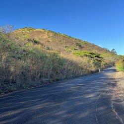
This was a really short hike! It is located on the west side of O'ahu, in Waianae. So keep driving all the way on the only road going towards Kaena Point. There is a parking area across the street and it's right before the first Kaena point sign (I believe). Make sure to not leave any bags or valuables (phone, GoPro, wallet, cash) in eyes view. It was pretty steep in the beginning. There is also a lot of gravel so it is slippery. The cave itself isn't deep or that big as it may seem when looking at it from the bottom. There are many ways to get up and down from the cave. Whichever you feel Most comfortable with. On the way down, as long as you're going towards the road then all should be fine. The view is great and even better during sunset. Sunset is beautiful over here. Definitely worth a hike if you're looking for something short and to get a little bit of a sweat!

A short half a mile hike but don't let the distance fool you. Although this hike is short, it is very steep. The rewards are a great workout and a beautiful view. Parking is available in a dirt lot off Farrington Highway next to a big rock that says Kaneana or next to the Kaena Point State Park sign. The start of the hike begins at a narrow path before the speed limit sign. All I can say is to be careful and best to go with a friend(s). The pathway is steep and narrow, the grass is very tall and overgrown, there are a lot of loose rocks, and there is a portion that levels but you'll be walking at the edge of the mountain. I recommend paying attention to where you're going and holding onto what you can. Best to stay close to the ground. I basically spider-monkeyed my way up. Going down was harder than going up. I scooted down on my butt most of the way. Take your time and listen to your body. Use sunscreen. Bring water. Wear long sleeve and/or long leggings due to all the overgrown grass. Be safe and enjoy the gorgeous view.

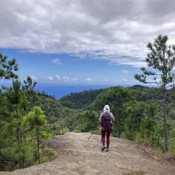
First time hiking this trail and it was a workout. Thankfully the trail is short but it's a constant up on non-paved trails that lead you through brushes, rocks, and tons of gravel. But the views! Beautiful. (And perfect spot to take the most goofiest photographs as all you really get are silhouettes as the sun is behind your back. We took plenty...enjoy the privilege of living or visiting paradise!) Parking is along the road and there's a couple of trail entrances. Take plenty of water and plan on sticking around for at least 20 minutes once you reach the top to truly take in the beauty of the space.

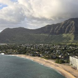
Another beauty the the west! There's so much skepticism for hikes on the West side because of the parking and what not. So my best advice is just to go during a popular time 10am+. I know the sun might be boiling you but if you're really concerned...then make a sacrifice! I've done this hike a couple of times already and looove it. Although it isn't the easiest hike, it sure is short. Around 20 minutes just to head up. The trail does incline up the mountain so this hike may be a little more strenuous for some. It really isn't the worst. Just wear some rigid shoes and take your time! Park at Makua Caves and keep walking down to the 45mph sign and you'll see a opening to the trail on the left.

My bestie is my go to person for hike recommendations. I guess she over estimates what I am able to handle. This hike is not for beginners. A good rule is anything with a rope is not for beginners. You can park on the side of the road on Farrington Highway. Find the path thru the long grass and follow up. It's a climb. Beware of loose rocks. When you get to the top of the rope, find the donkey path to the right. You will feel like you're walking on the edge of the mountain. Depending on your speed it's about 1/2 hour to 45 min just up. Awesome photo op. Be careful and have fun.

This hike is a short, yet strenuous one. Some yelpers said they took their young children on this hike, I would definitely not recommend that. There's a lot of loose dirt and it's extremely steep going up and even more challenging going down. There's no rope to help you up or down, just trees and dried grass. Make sure to bring water and wear long pants & shoes with grip! There's a lot of ways you can get cut.

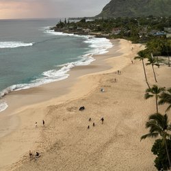
This is a pretty short hike with a beautiful view at the end of Waianae's beach. I did this hike a few times and thought I would write a review to help others be prepared for this hike. Toughness: I'd rate this hike 7/10 for medium hikers and not beginners because although it is short, there are a few sections of the hike that can be slippery and be a bit get difficult due to land corrosion. Parking: you can park on the side in the dirt area right across lower Makua Cave. when driving in you will see a huge cave (lower Makua cave) on your right side and the dirt parking will be on the left side. How to do the hike: Once you park, you will need to walk along the side of the road, right hand side if you are facing yoks beach. You will see a sign that says, "DANGER Live Ammunition..." do not be alarmed, but that is the marker I use to get to the beginning of the hike. Next, you will start walking through a grassy trail (Keep Right) and just keep going up. The grassy trail will lead to an area that starts to get rock, do not be alarmed you are still on the path, but beware that it starts to get kind of slippery due to the erosion of the rocks, so be careful. As you make your way past the slippery rocky area you will see a grassy hillside trail on the right which you will follow until you reach your destination. Tips: I would highly recommend wearing covered shoes that have good grip on the bottom. Be courteous to others and call out following rocks that may be cause by you when going through the slippery sections. Take your time going down the hill and make sure you have good footing before putting all your weight on the are. Lastly, take plenty of pictures and have fun!
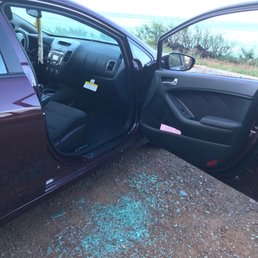
I want to warn everyone who park at Kaena Point Monument to hike The Upper Makua cave. Some lowlife sack of shit broke into my car today and busted my window while I was hiking with my friend. Just to steal my makeup bag... unbelievable!!! This is for you lowlife scumbag I hope Karma gets back at you! Other than that, the hike is short with a beautiful destination and view.

After a day at Yoks, we stopped alongside the road to do this little hike. Everybody's reviews about it being dangerous is pretty accurate... you're literally on the cliff. One thing to know is that you'll definitely be rock climbing so try to wear shoes with a decent amount of grip. I'm not saying you need to bring hiking boots but there are some smooth and loose rocks to climb on the way up so you'll feel safer if you had good shoes to hike with. The hike itself isn't that hard. There's different ways of going up to the caves so naturally, we took the "easier" route. The view is beautiful and definitely Instagram worthy. The best part was that it didn't take long to get to the top. It's short and sweet but it's definitely a work out. Going down is harder than going up IMO so take your time and have fun!


This hike is a hidden gem! It's really hard to find the path to get to the actual cave, and sadly i didn't make it to the cave but i was literally right below it and had the same view I would not recommend bringing animals or small children because there is a lot of loose rocks and it gets pretty steap! Great cardio in the famous west side heat!

Short hike with AMAZING views!!!! We saw a pod of dolphins, talked story with a shy mountain goat, and lusted over a shirtless guy showing off his 6 pack. How to Get There: Take Farrington Highway into Waianae all the way until you see Kaneana State Park on your left. There is a small parking lot for the lower cave BUT don't park there! Sure, stop and check out the lower cave if you want but the upper cave is where you want to be. Drive another 50ft to the speed limit sign and park there. You'll be able to see your car the whole time you're on the trail and less likely to get broken into. The Trail: Trail head is easy to find thanks to the "Danger Unexploded Ordinance do not enter" sign. Hold your breath, say a little prayer and trek on. The trail forks at the bottom of the hill: follow it to your right and always follow it to the right. The trail continues to the top of the mountain which is great, but remember you're looking for the upper cave which is in the middle of the mountain. Other Yelpers mentioned a rope but on 10/25/16 there was no rope. No rope, no problem! Just be sure the rocks you grab onto and step on are well grounded. The worse that can happen is you slide down a few feet OR drop a rock onto your fellow hiking friends. Can't wait to go back for a sunset hike during whale season! Trek on Yelpers!

"Down, down, down, downnnn...gravity! Helping wash the dishes, and I drop a cup. Why does everything fall down, instead of falling up? Riding up a hill, I spill and hit the ground, wish I could fall up instead of falling down. Down, Down, down, downnnnnnm..." I learned everything I need to know from Schoolhouse Rock...(YouTube:schoolhouserockgravity) I tried several times to write this straight-up, but that's not me. Headed to the westside, my boys and me rollin, 97.1 (which you'll lose after Waianae, but 94.7, or 93.9 cover the whole lsland) old school pumpin, sunroof open, smoke bellowin (not mine btw). The westside is a beautiful drive (I have fallin head-over for the westside!). Uncluttered pristine beaches, mom and pop's, cheap gas, no popo. The west is what Haleiwa used to be and more. You'll pass Nanakuli, Waianae, and Makaha, and just as you pass Kaneana Cave (The cave of man, thought in ancient times to be the birthplace), you'll go down. Trails are all to visible on the right. Park on the side of Farrington, and pick any trailhead from here, they all converge. Tips!!!!!! Anything you wanna keep, put in the trunk. Wear board shorts (girl or guy). If you are weary of scratches, wear long sleeves, in the shadow of mount Makua, it can be chilly anyway. Bring a beach towel...hopping in the ocean after is a must. Three steps (I'll not say it's easy or hard, but it's a great view and decent workout!): 1. You'll travel through undergrowth and brush. Trails are easy to follow; 2. Rock stairs, really you just work your gluteus here; 3. Is a little more difficult as you'll scramble your way up to the pathway to the caves. Lose rocks and grass shrubbery for hand holds. This is all at about a 45-50 degree angle. The path to Makua Caves is on the right, it's hard to miss. It's narrow and affords superb views. Follow this to the two caves where you can explore and take a break (plan on 45 minutes to one hour). Here's the thing. This is a fairly easy hike (thought you weren't gonna say that?), but after you see the caves, admire the view and head back, you'll notice the trailhead continues upward. If you wanna, go up, go up. Another thirty minutes of slip skidding (now at 60 degree) and you reach a solid rock wall. End of the line for me. For Brother Justin, however, it only began. Brother Justin is Spiderman! Ain't not two ways about it. He does all three peaks of Olomana like it's Kapiolani Park, he does Stairway bi-weekly. He freestyled Makua!!! (See pics!) While he was climbing, I noticed something, and this, I think, is important. There are really no restful places on this particular part of the hike. Wherever you sit or stand you feel it. A pulling sensation! Even on what seems to be level ground. It's really uncomfortable, yet exhilarating! Which leads me back... "Sir Isaac Newton underneath the apple tree, one hit him on the head, he said that must be Gravity!" This is or was a live fire range for US Military, and is considered an illegal hike. Enjoy, but be safe. I didn't fall during this hike, but Kyle did. :) Aloha Now go hit that beach!

6 years ago
Common for cars to get broken into here. Be careful!! View was nice, but we were already cautious with all the broken glasses in the floor.... Wouldn't recommend this trail because our car got broken into... read more

7 years ago
Access restricted...but that didn't stop my friend and I . The hike is fairly hard and you'll definitely break a sweat as it is very steep. Since access has been restricted, the trail is no longer maintained so plants are growing in the way and there are a lot of loose pebbles. Midway through the trail, you have to go across but there is no real place for footing so you're leaning on the wall scrambling across. That was probably the hardest and most scary part! Adrenaline rushing like crazy, woo. But the view is SO WORTH IT! It was a rewarding view for such a difficult hike. It'll take you twice as or even longer to get down. My friend and I had to sit and inch our way down because it was that steep! We had a laugh at the start of the trail which starts on the side of a highway because before there is a sign that says no trespassing. A cop car drove past and the cop inside the car waved as we were about to enter an access restricted trail to a car in Hawaii. Completely different from the NYC vibe! read more


One of the Leeward sides most iconic hikes (after Ka'ala Peak)! The view is worth the struggle. Park in the lot across the street and follow one of two trails... but this hike is so popular you can just follow the other hikers. I won't say it's easy but it is doable for adults and skilled adolescents. I hiked it after a heel injury which wasn't smart but I survived. 90% of the trail is crazy steep so bring crampons (the lightweight portable ones). You're welcome to try to bring hiking poles but in my opinion they're too dangerous on this hike (crampons better). You'll need a full camelback with water plus food for energy. Hat and sunscreen is a must as it's hot here year round (not like Windward side). Definitely a must do for all experienced hikers! Mahalo for reading my review. read more

This was a really short hike! It is located on the west side of O'ahu, in Waianae. So keep driving all the way on the only road going towards Kaena Point. There is a parking area across the street and it's right before the first Kaena point sign (I believe). Make sure to not leave any bags or valuables (phone, GoPro, wallet, cash) in eyes view. It was pretty steep in the beginning. There is also a lot of gravel so it is slippery. The cave itself isn't deep or that big as it may seem when looking at it from the bottom. There are many ways to get up and down from the cave. Whichever you feel Most comfortable with. On the way down, as long as you're going towards the road then all should be fine. The view is great and even better during sunset. Sunset is beautiful over here. Definitely worth a hike if you're looking for something short and to get a little bit of a sweat! read more


6 years ago
A short half a mile hike but don't let the distance fool you. Although this hike is short, it is very steep. The rewards are a great workout and a beautiful view. Parking is available in a dirt lot off Farrington Highway next to a big rock that says Kaneana or next to the Kaena Point State Park sign. The start of the hike begins at a narrow path before the speed limit sign. All I can say is to be careful and best to go with a friend(s). The pathway is steep and narrow, the grass is very tall and overgrown, there are a lot of loose rocks, and there is a portion that levels but you'll be walking at the edge of the mountain. I recommend paying attention to where you're going and holding onto what you can. Best to stay close to the ground. I basically spider-monkeyed my way up. Going down was harder than going up. I scooted down on my butt most of the way. Take your time and listen to your body. Use sunscreen. Bring water. Wear long sleeve and/or long leggings due to all the overgrown grass. Be safe and enjoy the gorgeous view. read more


First time hiking this trail and it was a workout. Thankfully the trail is short but it's a constant up on non-paved trails that lead you through brushes, rocks, and tons of gravel. But the views! Beautiful. (And perfect spot to take the most goofiest photographs as all you really get are silhouettes as the sun is behind your back. We took plenty...enjoy the privilege of living or visiting paradise!) Parking is along the road and there's a couple of trail entrances. Take plenty of water and plan on sticking around for at least 20 minutes once you reach the top to truly take in the beauty of the space. read more


Another beauty the the west! There's so much skepticism for hikes on the West side because of the parking and what not. So my best advice is just to go during a popular time 10am+. I know the sun might be boiling you but if you're really concerned...then make a sacrifice! I've done this hike a couple of times already and looove it. Although it isn't the easiest hike, it sure is short. Around 20 minutes just to head up. The trail does incline up the mountain so this hike may be a little more strenuous for some. It really isn't the worst. Just wear some rigid shoes and take your time! Park at Makua Caves and keep walking down to the 45mph sign and you'll see a opening to the trail on the left. read more

11 years ago
My bestie is my go to person for hike recommendations. I guess she over estimates what I am able to handle. This hike is not for beginners. A good rule is anything with a rope is not for beginners. You can park on the side of the road on Farrington Highway. Find the path thru the long grass and follow up. It's a climb. Beware of loose rocks. When you get to the top of the rope, find the donkey path to the right. You will feel like you're walking on the edge of the mountain. Depending on your speed it's about 1/2 hour to 45 min just up. Awesome photo op. Be careful and have fun. read more

This hike is a short, yet strenuous one. Some yelpers said they took their young children on this hike, I would definitely not recommend that. There's a lot of loose dirt and it's extremely steep going up and even more challenging going down. There's no rope to help you up or down, just trees and dried grass. Make sure to bring water and wear long pants & shoes with grip! There's a lot of ways you can get cut. read more


This is a pretty short hike with a beautiful view at the end of Waianae's beach. I did this hike a few times and thought I would write a review to help others be prepared for this hike. Toughness: I'd rate this hike 7/10 for medium hikers and not beginners because although it is short, there are a few sections of the hike that can be slippery and be a bit get difficult due to land corrosion. Parking: you can park on the side in the dirt area right across lower Makua Cave. when driving in you will see a huge cave (lower Makua cave) on your right side and the dirt parking will be on the left side. How to do the hike: Once you park, you will need to walk along the side of the road, right hand side if you are facing yoks beach. You will see a sign that says, "DANGER Live Ammunition..." do not be alarmed, but that is the marker I use to get to the beginning of the hike. Next, you will start walking through a grassy trail (Keep Right) and just keep going up. The grassy trail will lead to an area that starts to get rock, do not be alarmed you are still on the path, but beware that it starts to get kind of slippery due to the erosion of the rocks, so be careful. As you make your way past the slippery rocky area you will see a grassy hillside trail on the right which you will follow until you reach your destination. Tips: I would highly recommend wearing covered shoes that have good grip on the bottom. Be courteous to others and call out following rocks that may be cause by you when going through the slippery sections. Take your time going down the hill and make sure you have good footing before putting all your weight on the are. Lastly, take plenty of pictures and have fun! read more


 - Hiking Near Me - Waianae, Hawaii")
 - Hiking Near Me - Waianae, Hawaii")


 - Hiking Near Me - Waianae, Hawaii")

9 years ago
I want to warn everyone who park at Kaena Point Monument to hike The Upper Makua cave. Some lowlife sack of shit broke into my car today and busted my window while I was hiking with my friend. Just to steal my makeup bag... unbelievable!!! This is for you lowlife scumbag I hope Karma gets back at you! Other than that, the hike is short with a beautiful destination and view. read more


After a day at Yoks, we stopped alongside the road to do this little hike. Everybody's reviews about it being dangerous is pretty accurate... you're literally on the cliff. One thing to know is that you'll definitely be rock climbing so try to wear shoes with a decent amount of grip. I'm not saying you need to bring hiking boots but there are some smooth and loose rocks to climb on the way up so you'll feel safer if you had good shoes to hike with. The hike itself isn't that hard. There's different ways of going up to the caves so naturally, we took the "easier" route. The view is beautiful and definitely Instagram worthy. The best part was that it didn't take long to get to the top. It's short and sweet but it's definitely a work out. Going down is harder than going up IMO so take your time and have fun! read more


9 years ago
This hike is a hidden gem! It's really hard to find the path to get to the actual cave, and sadly i didn't make it to the cave but i was literally right below it and had the same view I would not recommend bringing animals or small children because there is a lot of loose rocks and it gets pretty steap! Great cardio in the famous west side heat! read more

Short hike with AMAZING views!!!! We saw a pod of dolphins, talked story with a shy mountain goat, and lusted over a shirtless guy showing off his 6 pack. How to Get There: Take Farrington Highway into Waianae all the way until you see Kaneana State Park on your left. There is a small parking lot for the lower cave BUT don't park there! Sure, stop and check out the lower cave if you want but the upper cave is where you want to be. Drive another 50ft to the speed limit sign and park there. You'll be able to see your car the whole time you're on the trail and less likely to get broken into. The Trail: Trail head is easy to find thanks to the "Danger Unexploded Ordinance do not enter" sign. Hold your breath, say a little prayer and trek on. The trail forks at the bottom of the hill: follow it to your right and always follow it to the right. The trail continues to the top of the mountain which is great, but remember you're looking for the upper cave which is in the middle of the mountain. Other Yelpers mentioned a rope but on 10/25/16 there was no rope. No rope, no problem! Just be sure the rocks you grab onto and step on are well grounded. The worse that can happen is you slide down a few feet OR drop a rock onto your fellow hiking friends. Can't wait to go back for a sunset hike during whale season! Trek on Yelpers! read more

 - Hiking Near Me - Waianae, Hawaii")


10 years ago
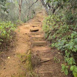
"Down, down, down, downnnn...gravity! Helping wash the dishes, and I drop a cup. Why does everything fall down, instead of falling up? Riding up a hill, I spill and hit the ground, wish I could fall up instead of falling down. Down, Down, down, downnnnnnm..." I learned everything I need to know from Schoolhouse Rock...(YouTube:schoolhouserockgravity) I tried several times to write this straight-up, but that's not me. Headed to the westside, my boys and me rollin, 97.1 (which you'll lose after Waianae, but 94.7, or 93.9 cover the whole lsland) old school pumpin, sunroof open, smoke bellowin (not mine btw). The westside is a beautiful drive (I have fallin head-over for the westside!). Uncluttered pristine beaches, mom and pop's, cheap gas, no popo. The west is what Haleiwa used to be and more. You'll pass Nanakuli, Waianae, and Makaha, and just as you pass Kaneana Cave (The cave of man, thought in ancient times to be the birthplace), you'll go down. Trails are all to visible on the right. Park on the side of Farrington, and pick any trailhead from here, they all converge. Tips!!!!!! Anything you wanna keep, put in the trunk. Wear board shorts (girl or guy). If you are weary of scratches, wear long sleeves, in the shadow of mount Makua, it can be chilly anyway. Bring a beach towel...hopping in the ocean after is a must. Three steps (I'll not say it's easy or hard, but it's a great view and decent workout!): 1. You'll travel through undergrowth and brush. Trails are easy to follow; 2. Rock stairs, really you just work your gluteus here; 3. Is a little more difficult as you'll scramble your way up to the pathway to the caves. Lose rocks and grass shrubbery for hand holds. This is all at about a 45-50 degree angle. The path to Makua Caves is on the right, it's hard to miss. It's narrow and affords superb views. Follow this to the two caves where you can explore and take a break (plan on 45 minutes to one hour). Here's the thing. This is a fairly easy hike (thought you weren't gonna say that?), but after you see the caves, admire the view and head back, you'll notice the trailhead continues upward. If you wanna, go up, go up. Another thirty minutes of slip skidding (now at 60 degree) and you reach a solid rock wall. End of the line for me. For Brother Justin, however, it only began. Brother Justin is Spiderman! Ain't not two ways about it. He does all three peaks of Olomana like it's Kapiolani Park, he does Stairway bi-weekly. He freestyled Makua!!! (See pics!) While he was climbing, I noticed something, and this, I think, is important. There are really no restful places on this particular part of the hike. Wherever you sit or stand you feel it. A pulling sensation! Even on what seems to be level ground. It's really uncomfortable, yet exhilarating! Which leads me back... "Sir Isaac Newton underneath the apple tree, one hit him on the head, he said that must be Gravity!" This is or was a live fire range for US Military, and is considered an illegal hike. Enjoy, but be safe. I didn't fall during this hike, but Kyle did. :) Aloha Now go hit that beach! read more


How often do you look out at a place in Hawaii and say damn #luckyweliveinhawaii. All the time right? Yah, me too. Well this weekend I thought this yet once again, except I was in a place a bit unfamiliar to me - The West Side. Now before you townies freak out about how long the drive is and blah blah trust me on this one you're going to want to make the trek. I was looking for an easy but rewarding Sunday hike and came across this hike on http://www.unrealhawaii.com/2012/09/upper-makua-cave/- by David Chat, one of my favorite hiking bloggers. I had seen it before but was always hesitant by the car theft warnings, especially since I wasn't the one that would be driving. Turns out that the place you park the car - Kaneana Cave attracts many tourists so there always seems to be cars coming in an out - making it less likely that your car will get jacked. :) There are 2 sites I looked at to direct me exactly to the cave because if you don't know where you are going. You will 1. get lost 2. wont find it *My word of advice is take a picture of their route on your phone and you will 100% guarantee find it. a. http://hawaiianforest.com/upper-makua-cave b. http://punynari.wordpress.com/2012/07/03/upper-makua-cave-and-beach-bunkers/ There's a spot after you make the ascent up the hill that you may question where to go next. You'll look to the right and you'll see a grassy area, find the trail (yes there is one) and follow that around the rock http://www.yelp.com/user_local_photos?select=ruC8HnqA0NV_hWXqnYTscw&userid=QkQLnujuiBDP1mNChJYJww and soon you'll be at the cave. http://www.yelp.com/user_local_photos?select=034-jJKvN0Q58y46TjXC7g&userid=QkQLnujuiBDP1mNChJYJww David Chat rates this as intermediate. Here's why. There's falling rocks as you climb the steep ascent to the cave. I kinda sprinted up it, and tried doing the same on the way down. I DO NOT recommend that. Have one person descend the hill all the way to the tree and then make your way down. None of the rocks are stable so don't even risk it. No one wants an injury after having an epic hike. Another great thing about this hike is that it'll take you less time to climb it than to drive to the actual spot. Yes, its that short of a hike. Happy hiking! :) read more


Successfully accomplished this hike, It was only hard for us because we were going the wrong way. PLEASE don't make the same mistake we did. If other reviewers are saying start at the " 25 MPH Sign " please start there. We went by another sign that said 'No Trespassing' - DO NOT. GO. THAT. WAY. - it'll seriously confuse you. The starting point from the 25mph sign is pretty straightforward. Just to go all the way up. It is a strenuous hike, so be careful. What seemed like a 20 minute hike actually took us an hour and a half because we went the wrong route and refused to climb back down and start over. But seeing other hikers coming down a what looked like a path made us walk over to the actual path to the hike is when we got back on track. read more


12 years ago
Located on the road less traveled, West Side Oahu. Yea you gotta drive through Waianae to get there, but Waianae doesnt seem sooooooooo bad lately Lol. Anyways to get to this one drive up to Keana Point and part next to Lower Makua Cave. That's right off Farrington. To get to Upper Makua Cave, walk 100 yards or so to the 45mph sign, that's the "trailhead". The hike is short, but makes you work. Phase 1 = tall shrubbery (it's rainy season so growth is in FULL force), phase 2 = a steep incline that's mainly loose rock. Be careful here. Phase 3 = when you get to the second teir you might notice a faint goat trail. Follow that trail to the cave. Be careful, monkeying around here and a tumbling you will go. Phase 4 = get to the cave and chill out and take a million pics. Really try and enjoy the vibe up there. read more


7 years ago
Beautiful hike! It is very steep and I was literally hugging the rocks on my way up. Watch out for loose dirt since this is a restricted are and is not being maintained. Tip: stay on the side where there are bug rocks that you know will not fall. Be safe and have fun! read more


12 years ago
Thank you fellow yelpers for the directions that has lead me to this short, sweet (and hot) hike with rare breathtaking views of the far west side of the island! I have to mention that the drive from town to the site is just as long as the hike. Meaning prepare for a lengthy ride to the country. Check out the glitter sand beaches along the way, most beaches are not overpopulated with tourists, ample parking. Keep driving until you finally start thinking "are we there yet?!" You'll reach the lower makua cave to the right, although you might miss it because the entrance faces away from the road. Park in the dirt lot with a rock that says "KANEANA." From here cross the street and begin walking. You can kind of make up the distinct shadows of the cave from the road, it will be on the rock mountain above of the lower makua cave. Find the trailhead. This is where you explore... I found the entrance by an area of what seems to be burnt shrubbery from a fire? Follow the unmaintained trail through more shrubs. There are many split ways in the shrubs but for the most part it takes you to the same area which is the more rockier and steep portion that also involves a little rope climbing. I would say this hike was a good 30-40min only cuz it was our first time, and also because it was blazing hot!!! NO SHADE until you get to the cave. The view is absolutely priceless and well worth the drive and quick hike. Be fully prepared with a full tank of gas, I've cold water, shades, hat, sunscreen and of course your gopro or camera! FYI AT&T has little or no reception in this area. Enjoy! read more


12 years ago
You're trespassing on Government Property to do this hike. Hike at your own risk. Very, very short - but challenging! Good shoes are key, as is being hands free. It's steep and the footing can be very loose. This hike is not for children. read more


8 years ago
GO IN BETWEEN THE TREES! Start AT the 25mph sign and take that trail through the 3 trees. It's the easier option. There are a bunch of different paths so it's easy to get confused. Just keep going to the trees and then right in between them until you reach a clear landing, THATS when you turn right to the easier trail around the mountain ridge. I learned the hard way and took another trail...learned from another hiker to go in between the trees on the way down and it was SO much easier. It's not a very easy hike so come prepared for that. Very steep and the rocks are very very loose! The view makes up for it :) read more


This is a very special place but feel that it shouldn't be considered a hike. It takes about 20 minutes to reach the cave. The "trail" is quite crumbly, due to the wear and tear of people going up and down throughout the day. I asked a friend to bring us here for the sunset. It was beautiful. Nothing short of breathtaking and picturesque. The westside has such an untouched beauty that no matter when I am there, I always stop and take the time to soak in its beauty. read more


5 years ago
12 years ago
This hike was actually pretty fast! It's a bit chAllenging. I wouldn't recommend you bring your kids up here. I would recommend wearing good gripped shoes and maybe high socks cause those branches can be a pain to walk through. You park outside of Makua cave on that dirt lot and just walk a bit down the road until you reach the speed limit sign. From there you just make your way up the mountain. There's different paths but it'll all lead to the top. You're basically just walking at a steep incline through all the plants and over some loose rocks. You'll get to a rope, which will help you go up further and come down easier. Once you reach the top of the rope, just go right and scale the mountain until you reach the cave! The view is Amazing and it's pretty worth it. Just be careful and don't slide on your way down. Cause I slid down about two times haha. read more


Caution when doing this hike...there is a sign that says Government Property Keep Out Im sure everyone knows what that means. It's not a super busy hike and I can only imagine because it's far from everything and there is a sign that says keep out. The views from this hike are breathtaking no where else on this island can you find a place. The beaches nearby are gorgeous. The cave isn't huge and there is nothing special about it but the view. Going up and down is a little tricky because of the falling rocks and dirt. Not recommended for children. You could possibly see goats so don't freak out lol read more


So this hike is quite different from pretty much any other hike I have been on so far. We followed suggestions from previous reviewers and parked in the dirt lot on the Makai side of the street with the "Kaena Point Makua" something sign. Crossed the street and walked down a few paces to the speed limit sign and looked for an obvious path. I wouldn't really call it difficult (for me) but that depends on your fitness level, but definitely a good challenge. I know that sounds contradictory but I have a slight phobia of vegetation, and the beginning of the hike has pretty tall shrubbery that closes in on you. There is no true path, it is more of which paths were most frequently used so you take your pick. Which ever you choose will eventually lead you to the caves. The shrubbery will eventually thin out completely and then the terrain gets that much more challenging. It gets a lot steeper and the ground a lot more unstable - loose rocks so watch your footing. It will seem like there is a channel between the rock formations as you get closer to the top and then a path veering to the right, around to the side facing the street. That's where the caves are. It was well worth it. We got some pretty good pics and the view was great. But let me tell you, going down was even more of an adventure! Your shoes better have some traction, or you could very well slide down some parts of the mountainside. All in all, great hike. I'd do it again, vegetation and all. **didn't see the "unexploded ordnance" sign until after we were done. read more


12 years ago
10 years ago
How to find the trail: Drive along Farrington Hwy until you get to the parking lot on the left that says KANEANA on it and park there. Then walk down the Hwy and when you get to the SPEED LIMIT sign you'll see a trail. The trail will split up a lot but you'll get to a point where you go right or left and you want to go right! We made the mistake of going left haha Got an awesome view tho! How long is the hike: I would say easily 20-25 mins up and maybe 15 mins down? Not very long so maybe plan to do some other things while you're out there like the Mermaid caves, Makaha beach or even the Maili pillbox hike. How hard is the hike: It was honestly easier than expected! If you've done Lanikai pillboxes then it's easier and shorter than that. We went up around 10:30am and it wasn't very hot, definitely take a bottle of water with you but you won't need too much. read more


12 years ago
12 years ago
Breathtaking views ! I can't believe I've lived in Hawaii and on the West Side most of my life and haven't been to the spot. This hike is no joke though I thought going up was a little tough but it's nothing like coming down the rocks are so unstable you're better off doing what I did and pretty much sliding down making sure I was close to the ground. It didn't help me much because I still ended up standing and falling and slipping and what I hopefully think it is spraining my ankle but it was all worth that view. We went about 8:30 in the morning and we Heights with couple that was visiting Hawaii they never did this hike so they thought they tag along thinking that we've done this before LOL but we all made it up together. Two kids and an old man my dad LOL the kids somewhere 10 + 8 and they did real well. When coming down there are more hikers which made it a little difficult maneuvering around them. This is a must-do hike overall I think it took us an hour a little over maybe because we spent some time at the top enjoying the views maybe not a hike for the first time hikers but definitely a must do ! read more

10 years ago
10 years ago
11 years ago
Really short, but it's steep with lots of crumbly rocks/dirt. So worth it though - amazing views up there, and the upper cave is very unique. My human wears cleats on this one. read more


Page 1 of 2
More info about Upper Makua Cave - Access Restricted
82-180 Farrington Hwy
Waianae, HI 96792
Directions
Hours
Outdoor Amenities
Upper Makua Cave - Access Restricted Reviews in Other Languages
Ask the Community - Upper Makua Cave - Access Restricted
Why is this access restricted lol?
For a few reasons. 1. It is federal property and a crime to do so. There are signs every 40ft or…
Review Highlights - Upper Makua Cave - Access Restricted
You might also consider


Why does Yelp recommend reviews?
4 reviews that are not currently recommended
The reviews below are not factored into the business's overall star rating.
12 years ago
4 years ago
11 years ago
4 years ago
Upper Makua Cave - Access Restricted - hiking - Updated July 2026
Best of Waianae
People found Upper Makua Cave - Access Restricted by searching for…
Trending Searches in Waianae, HI
Blueberry Picking near Upper Makua Cave - Access Restricted
Cliff Jumping near Upper Makua Cave - Access Restricted
Day Trips near Upper Makua Cave - Access Restricted
Dog Friendly Beaches near Upper Makua Cave - Access Restricted
Jet Ski Rental near Upper Makua Cave - Access Restricted
Kayak Rental near Upper Makua Cave - Access Restricted
Lakes & Ponds near Upper Makua Cave - Access Restricted
Off Road Trails near Upper Makua Cave - Access Restricted
Outdoor Activities near Upper Makua Cave - Access Restricted
Places To Swim near Upper Makua Cave - Access Restricted
Places To Walk Around near Upper Makua Cave - Access Restricted
Pokemon Go near Upper Makua Cave - Access Restricted
Pool Day Pass near Upper Makua Cave - Access Restricted
Public Shower near Upper Makua Cave - Access Restricted
Public Swimming Pools near Upper Makua Cave - Access Restricted
River Swimming near Upper Makua Cave - Access Restricted
River Tubing near Upper Makua Cave - Access Restricted
Rock Quarry near Upper Makua Cave - Access Restricted
Scenic Night View near Upper Makua Cave - Access Restricted
Scenic Overlook near Upper Makua Cave - Access Restricted
Secluded Spots near Upper Makua Cave - Access Restricted
Soccer Store near Upper Makua Cave - Access Restricted
Sunrise View near Upper Makua Cave - Access Restricted
Swimming Holes near Upper Makua Cave - Access Restricted
Swimming Lakes near Upper Makua Cave - Access Restricted
U Pick Farms near Upper Makua Cave - Access Restricted
Watch Sunset near Upper Makua Cave - Access Restricted
Waterfalls And Swimming Holes near Upper Makua Cave - Access Restricted
Browse Articles
Browse Nearby
BEST of Waianae, Hawaii Restaurants near Upper Makua Cave - Access Restricted
BEST of Waianae, Hawaii Coffee near Upper Makua Cave - Access Restricted
BEST of Waianae, Hawaii Things to Do near Upper Makua Cave - Access Restricted
BEST of Waianae, Hawaii Beaches near Upper Makua Cave - Access Restricted
BEST of Waianae, Hawaii Breakfast near Upper Makua Cave - Access Restricted
Browse Brands
Related Searches in Waianae, HI
Affordable Kayak Rental Services in Waianae, Hawaii
Best Dog Hiking Trails Around Waianae, Hawaii
Best Fishing Locations and Guides in Waianae, Hawaii
Best Nature Trails for Hiking in Waianae, Hawaii
Best Places for Horseback Riding in Waianae, Hawaii
Best Sightseeing Experiences Available in Waianae, Hawaii
Best Waterfalls and Swimming Holes in Waianae, Hawaii
Discover Dog Friendly Trails to Explore in Waianae, Hawaii
Discover Easy Hiking Trails Near Waianae, Hawaii
Discover Kid Friendly Hiking Trails in Waianae, Hawaii
Discover Popular Bike Trails in Waianae, Hawaii
Discover Scenic Mountain Bike Trails Near Waianae, Hawaii
Discover Top Nature Parks to Visit in Waianae, Hawaii
Discover Walking Parks in Waianae, Hawaii Near You
Discover a Hiking Trail in Waianae, Hawaii
Discover the Best Night Hike Trails in Waianae, Hawaii
Dog-Friendly Hikes With Dogs in Waianae, Hawaii
Enjoy Camping Adventures Around Waianae, Hawaii
Enjoy Kayaking Adventures in Waianae, Hawaii
Enjoy Off Leash Dog Hikes in Waianae, Hawaii
Enjoy Tent Camping Spots Around Waianae, Hawaii
Enjoy a Beautiful Waterfall Hike in Waianae, Hawaii
Enjoy the Best Walking Path in Waianae, Hawaii
Enjoy the Best Walking Trails in Waianae, Hawaii
Explore Easy Hikes Perfect for All in Waianae, Hawaii
Explore Fun Activities to Do in Waianae, Hawaii
Explore Popular Campgrounds Near Waianae, Hawaii
Explore Popular State Park Destinations in Waianae, Hawaii
Explore Top Dog Parks in Waianae, Hawaii Near You
Explore the Best Beach Spots in Waianae, Hawaii
Family Friendly Hiking With Kids in Waianae, Hawaii
Find Cozy Camping Cabins in Waianae, Hawaii
Find Popular Ziplining Spots Around Waianae, Hawaii
Find Top Dog Friendly Parks to Visit in Waianae, Hawaii
Find Top-Rated Waterfalls in Waianae, Hawaii Now
Find the Best Parks for Picnics in Waianae, Hawaii
Hiking Trails With Waterfalls in Waianae, Hawaii
Off Leash Dog Hiking Trails in Waianae, Hawaii
Picnic Areas With BBQ Pits Available in Waianae, Hawaii
Popular Outdoor Activities to Try in Waianae, Hawaii
Popular Picnic Spots to Visit in Waianae, Hawaii
Popular Waterfall Hiking Trails in Waianae, Hawaii
Safe and Fun Parks for Kids in Waianae, Hawaii
Top Hiking Trails to Explore in Waianae, Hawaii
Top Playgrounds for Kids to Enjoy in Waianae, Hawaii
Top Running Trails to Explore in Waianae, Hawaii
Top Things to Do With Kids in Waianae, Hawaii
Top-Rated Camping Sites in Waianae, Hawaii