Mauna Lahilahi Photos


You might also consider
More like Mauna Lahilahi
Recommended Reviews - Mauna Lahilahi
Start your review...

Reviews With Photos

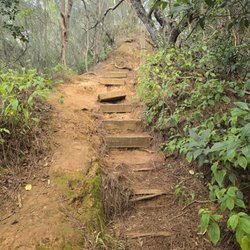
Short (less than 1.5 miles round trip) but steep trail up. Don't recommend kids or dogs as the trail is very narrow and the drop is very long - not to mention full of thistles, thorns and sharp rocks/edges. The beauty of this place though...WOW! Parking is along the street and plentiful. Went for a sunset hike but the clouds ended up obscuring the final descent. It was worth the trip anyway and I'll try to go again when the skies are not so cloudy. The weather on this side of the island tend to remain consistently beautiful - even when it's raining elsewhere on the island, this side tends to be dry so usually my backup plan. This is the first time I've done this trail though and happy for it.

I'm a "beginner hiker" and this was definitely not an easy hike for my daughters and I. It literally was rock climbing at the edge of a mountain! One wrong step and you'll end up at the bottom of the ocean! I could just be over exaggerating but my oldest & youngest daughters- 16 & 12 years old didn't even make it half way because they were too scared. My 2nd oldest- 15yrs. old made it a little further but she ended up stopping as well. It was definitely our first and last hike/ mountain climb on that mountain! On a positive note- the view was definitely beautiful and the sunset was breathtaking. Glad I can say I did it once!

I stay within walking distance from Mauna Lahilahi in the Makaha Valley area of Wai'anae. Mauna Lahilahi is basically a giant lava rock. There are signs that tell you it is dangerous territory. Upon walking in, my babe and I were greeted by two hens and a rooster. Further into the foothills of Mauna Lahilahi are homeless camps but the people aren't out to bother hikers. Short hike, mostly climbing rocks. Steep, but stable. No need for too much hiking gear. A fanny pack was just fine. Some people may need both hands free to grab onto rocks. Totally dangerous, phenomenal view. Trailhead is on Lahilahi street.

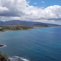
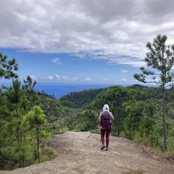
If you're looking for a short hike while visiting Makaha, this place has to offer. Located by Makaha Beach by the residential area, the trail is short about less than 20 minutes to the summit. It is a small rocky hill, sketchy to get you to the top. Narrow path on the top, so pay extra attention for your safety. Once you're at the top, it is amazing view of the west coast and the valley of Waianae range; one of the volcano that build the island of Oahu. No parking in the area, so park at your own risk.

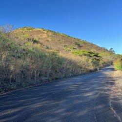
This is definitely a short and rewarding hike on the west side of Oahu. To get here, you turn left off of farrington highway onto Lahilahi street. It's right before Makaha beach. You will see a fence that is the entrance to the trail and street parking off to the right of the fence. To get to the trial head you go around the fence and at the fork you make a left. You will come to a white and red sign Danger sign and you take a left up the trail head. Whatever you do on the trail, go LEFT. You will come to areas on the mountain that will seem like the right way but to get to the actual top of the mountain the easiest way is up the left side of the mountain. You can avoid the 'rock climbing' part that someone else posted about if you go up the left side. That 'rock climbing' part is to the right of the mountain. It is also easier going down that way too. It can be a little scary if it's a little windy.

Don't recommend if you are afraid of heights. There were some moments on this hike where I did feel a little bit queasy. And a little bit anxious but besides that I think that this hike was definitely worth the time and the drive. There are breathtaking views at the top you can see all of makaha valley and waianae. I would say I don't need more than 20 to 30 minutes to get to the top and maybe like 15 to get back down. The air at the top is fresher than on the ground and the sunset views were to die for. Simply amazing. If you're ever on the side of the island highly recommend this hike! There's a small little beach called Cabanas right below it as well and a few Times that I had been there swimming I saw a dolphins!

Quick and easy hike with AMAZING views. This hike can be done in slippahs but since there is a lot of broken glass in the area and light scrambling involved so I strongly recommend good shoes. One of my friends was full of fear to do this hike, because 1) she's afraid of heights and 2) we were hiking it a sunset which meant no lights on the way down. Of course we had headlamps but that only goes so far. My only fear was my car being broken into. Thankfully my friend made it unscathed and so did my car! We parked at the beach parking lot off of Farrington Hwy (if you're driving towards Makaha the lot will be on your left after the Makaha Beach Cabanas Hawaiian Princess Resort) to lessen the chances of our car being broken into and then walked down Lahilahi Street to the trailhead. Well, technically there is no trailhead since there's no trail. Have fun and make your own "trail" but we found staying left was the easiest way! Trek on Yelpers!
The gratification density (views per effort worked) is off tha hook. I've seen this rock driving by before but after seeing some photos online decided to check it out myself. Much to my surprise there's parking off the side of the road right in front of the rock on Lahilahi street. I'm sure there's multiple points of entry but we entered sort of on the right side past the fence and past the danger sign. It was a pretty safe hike up overall. There wasn't really a defined path so it's a choose your own adventure sort of deal. Some of the rocks are loose so watch your step and there are spiky plants around so beware of that. Took us about ~10 minutes to get to the top where there is a Hawaiian flag. You can go past a little further and be welcomed to an absolutely unreal 360 view of the west side. Ocean, beach, mountains, it's got it all. I took what was probably my all time favorite photo here but unfortunately it's too large for Yelp to let me upload but if you're interested I put it up on my Flickr. https://flic.kr/p/KNQuPN Highly recommended climb if you're in the area on a sunny day.

Follow the east side of the ridge and you'll find the top, don't do it on a windy day!!! A few places you need to use hands to pull yourself up and before you know it, you'll be at the top!! Don't forget camera!!!! Don't fret, the coast guard will save you if you're too chicken to come down!!!!

Easy hike if you go up the right way/left side of the rock facing the ocean. Going down is much easier than going up which can get steep and scary with loose rocks here and there. We did this hike with a 10 y.o. and were up in 15 mins but be warned that not all kids will be comfortable as it can be gnarly for adults alike. The views atop are surreal! Makaha Valley never looked so good.

Easy hike like only 10 mins to the top. But there is one dangerous part you must pass that requires you to do some rock climbing. And jus because of the part I don't recommend it for young children. The trail is there and easy to find jus watch out for loose rocks. Enjoy the view when you get to the top its absolutely amazing!!!


Great short hike with a great view. Wear sneakers and get ready to rock climb at one part. Looking from the trail, the right side of the rock climbing was harder but a lot faster, just be sure to watch your footing. Took about 10min to the top and the sunset view was completely worth it. Be careful going down, there are a few loose dirt spots here and there but overall good terrain even with a little overgrown grass. Looking from the top, it was definitely easier to go down the right side instead of the left side which is the tougher side.

Now this was a fun and short hike! The older I get and the older age of the guests I take on hikes, the more interested I am in completing hikes that get straight to the point - the view! This hike falls in that category. Make your way to Makaha and park on a neighborhood street. Please be respectful of where and how you park to show respect to the locals living in the area. Please ensure to not leave any trash and if you see any, please pick it up and dispose of it properly. It's just a short 3-minute walk to the base of the little hike. I believe it took us 15-20 minutes to make it to the top. I felt comfortable enough to allow my 5 year old daughter hike on her own with my supervision. There were a couple challenging spots, but as long as you push through, you should be good. The view from the stop is absolutely stunning. Since the hike is on the makai side, you can capture a full 360 view around. P.S. Waianae/Makaha is synonymous with choke homeless people and Hawaiians. Please plan appropriately. read more


6 years ago
SUPER short hike, but really breathtaking views! Came with a friend, and we hiked up about half the mountain. She decided not to do the bit of "rock climbing" involved, and stayed behind with my dog. Still a very worthwhile view for just 10 minutes of work (or less). I went on, and while the rock climbing was very short, it is not for everyone. It is not extremely clear how to climb it (for someone without a lot of rock climbing experience aka me), but if you were to fall, the probably of it being fatal seems low. Gorgeous views to your left and right when you get to the top. Skip the "right fork". Just a little beach walk. We were done with both sides in less than an hour. read more


3 years ago
Short (less than 1.5 miles round trip) but steep trail up. Don't recommend kids or dogs as the trail is very narrow and the drop is very long - not to mention full of thistles, thorns and sharp rocks/edges. The beauty of this place though...WOW! Parking is along the street and plentiful. Went for a sunset hike but the clouds ended up obscuring the final descent. It was worth the trip anyway and I'll try to go again when the skies are not so cloudy. The weather on this side of the island tend to remain consistently beautiful - even when it's raining elsewhere on the island, this side tends to be dry so usually my backup plan. This is the first time I've done this trail though and happy for it. read more


 - Hiking Near Me - Waianae, Hawaii")


6 years ago
I'm a "beginner hiker" and this was definitely not an easy hike for my daughters and I. It literally was rock climbing at the edge of a mountain! One wrong step and you'll end up at the bottom of the ocean! I could just be over exaggerating but my oldest & youngest daughters- 16 & 12 years old didn't even make it half way because they were too scared. My 2nd oldest- 15yrs. old made it a little further but she ended up stopping as well. It was definitely our first and last hike/ mountain climb on that mountain! On a positive note- the view was definitely beautiful and the sunset was breathtaking. Glad I can say I did it once! read more

6 years ago
I stay within walking distance from Mauna Lahilahi in the Makaha Valley area of Wai'anae. Mauna Lahilahi is basically a giant lava rock. There are signs that tell you it is dangerous territory. Upon walking in, my babe and I were greeted by two hens and a rooster. Further into the foothills of Mauna Lahilahi are homeless camps but the people aren't out to bother hikers. Short hike, mostly climbing rocks. Steep, but stable. No need for too much hiking gear. A fanny pack was just fine. Some people may need both hands free to grab onto rocks. Totally dangerous, phenomenal view. Trailhead is on Lahilahi street. read more


6 years ago
If you're looking for a short hike while visiting Makaha, this place has to offer. Located by Makaha Beach by the residential area, the trail is short about less than 20 minutes to the summit. It is a small rocky hill, sketchy to get you to the top. Narrow path on the top, so pay extra attention for your safety. Once you're at the top, it is amazing view of the west coast and the valley of Waianae range; one of the volcano that build the island of Oahu. No parking in the area, so park at your own risk. read more


8 years ago
This is definitely a short and rewarding hike on the west side of Oahu. To get here, you turn left off of farrington highway onto Lahilahi street. It's right before Makaha beach. You will see a fence that is the entrance to the trail and street parking off to the right of the fence. To get to the trial head you go around the fence and at the fork you make a left. You will come to a white and red sign Danger sign and you take a left up the trail head. Whatever you do on the trail, go LEFT. You will come to areas on the mountain that will seem like the right way but to get to the actual top of the mountain the easiest way is up the left side of the mountain. You can avoid the 'rock climbing' part that someone else posted about if you go up the left side. That 'rock climbing' part is to the right of the mountain. It is also easier going down that way too. It can be a little scary if it's a little windy. read more


7 years ago
Don't recommend if you are afraid of heights. There were some moments on this hike where I did feel a little bit queasy. And a little bit anxious but besides that I think that this hike was definitely worth the time and the drive. There are breathtaking views at the top you can see all of makaha valley and waianae. I would say I don't need more than 20 to 30 minutes to get to the top and maybe like 15 to get back down. The air at the top is fresher than on the ground and the sunset views were to die for. Simply amazing. If you're ever on the side of the island highly recommend this hike! There's a small little beach called Cabanas right below it as well and a few Times that I had been there swimming I saw a dolphins! read more


Quick and easy hike with AMAZING views. This hike can be done in slippahs but since there is a lot of broken glass in the area and light scrambling involved so I strongly recommend good shoes. One of my friends was full of fear to do this hike, because 1) she's afraid of heights and 2) we were hiking it a sunset which meant no lights on the way down. Of course we had headlamps but that only goes so far. My only fear was my car being broken into. Thankfully my friend made it unscathed and so did my car! We parked at the beach parking lot off of Farrington Hwy (if you're driving towards Makaha the lot will be on your left after the Makaha Beach Cabanas Hawaiian Princess Resort) to lessen the chances of our car being broken into and then walked down Lahilahi Street to the trailhead. Well, technically there is no trailhead since there's no trail. Have fun and make your own "trail" but we found staying left was the easiest way! Trek on Yelpers! read more


10 years ago
The gratification density (views per effort worked) is off tha hook. I've seen this rock driving by before but after seeing some photos online decided to check it out myself. Much to my surprise there's parking off the side of the road right in front of the rock on Lahilahi street. I'm sure there's multiple points of entry but we entered sort of on the right side past the fence and past the danger sign. It was a pretty safe hike up overall. There wasn't really a defined path so it's a choose your own adventure sort of deal. Some of the rocks are loose so watch your step and there are spiky plants around so beware of that. Took us about ~10 minutes to get to the top where there is a Hawaiian flag. You can go past a little further and be welcomed to an absolutely unreal 360 view of the west side. Ocean, beach, mountains, it's got it all. I took what was probably my all time favorite photo here but unfortunately it's too large for Yelp to let me upload but if you're interested I put it up on my Flickr. https://flic.kr/p/KNQuPN Highly recommended climb if you're in the area on a sunny day. read more


10 years ago
Follow the east side of the ridge and you'll find the top, don't do it on a windy day!!! A few places you need to use hands to pull yourself up and before you know it, you'll be at the top!! Don't forget camera!!!! Don't fret, the coast guard will save you if you're too chicken to come down!!!! read more


Easy hike if you go up the right way/left side of the rock facing the ocean. Going down is much easier than going up which can get steep and scary with loose rocks here and there. We did this hike with a 10 y.o. and were up in 15 mins but be warned that not all kids will be comfortable as it can be gnarly for adults alike. The views atop are surreal! Makaha Valley never looked so good. read more


11 years ago
Easy hike like only 10 mins to the top. But there is one dangerous part you must pass that requires you to do some rock climbing. And jus because of the part I don't recommend it for young children. The trail is there and easy to find jus watch out for loose rocks. Enjoy the view when you get to the top its absolutely amazing!!! read more


5 years ago
10 years ago
I wasn't sure what way to go so I kinda just winged it!! Not too bad, when u go over the fence go to the right (not left). It seemed easier that way. You can usually go around the bigger boulders. The view is awesome. Total 360 of mountains and ocean. Just beautiful. read more


 - Hiking Near Me - Waianae, Hawaii")


10 years ago
Great short hike with a great view. Wear sneakers and get ready to rock climb at one part. Looking from the trail, the right side of the rock climbing was harder but a lot faster, just be sure to watch your footing. Took about 10min to the top and the sunset view was completely worth it. Be careful going down, there are a few loose dirt spots here and there but overall good terrain even with a little overgrown grass. Looking from the top, it was definitely easier to go down the right side instead of the left side which is the tougher side. read more

If you want to take a short beautiful hike on the Westside, come to Mauna Lahilahi. It takes about 15 minutes to the top and I would suggest going at sunset. Don't forget to bring flashlights if you do that way when you're going back down you can see where you're going! It's such a beautiful and peaceful place to gather your thoughts and reflect if you need some alone time. read more


9 years ago
More info about Mauna Lahilahi
Mauna Lahilahi Reviews in Other Languages
Ask the Community - Mauna Lahilahi
Review Highlights - Mauna Lahilahi


Mauna Lahilahi - hiking - Updated August 2026
Best of Waianae
People found Mauna Lahilahi by searching for…
Trending Searches in Waianae, HI
Blueberry Picking near Mauna Lahilahi
Cliff Jumping near Mauna Lahilahi
Cruising Spots near Mauna Lahilahi
Dog Friendly Things To Do near Mauna Lahilahi
Flower Fields near Mauna Lahilahi
Jet Ski Rental near Mauna Lahilahi
Kayak Rental near Mauna Lahilahi
Kids Activities Indoor near Mauna Lahilahi
Lookout Points near Mauna Lahilahi
Outdoor Activities near Mauna Lahilahi
Picnic Areas near Mauna Lahilahi
Rainy Day Activities near Mauna Lahilahi
River Swimming near Mauna Lahilahi
Rock Quarry near Mauna Lahilahi
Scenic Overlook near Mauna Lahilahi
Shopping Malls near Mauna Lahilahi
Sunrise View near Mauna Lahilahi
Swimming Holes near Mauna Lahilahi
Things To Do On A Rainy Day near Mauna Lahilahi
Browse Articles
Browse Nearby
BEST of Waianae, Hawaii Coffee near Mauna Lahilahi
BEST of Waianae, Hawaii Restaurants near Mauna Lahilahi
BEST of Waianae, Hawaii Things to Do near Mauna Lahilahi
BEST of Waianae, Hawaii Parks near Mauna Lahilahi
BEST of Waianae, Hawaii Waterfalls near Mauna Lahilahi
Browse Brands
Related Searches in Waianae, HI
Affordable Kayak Rental Services in Waianae, Hawaii
Best Dog Hiking Trails Around Waianae, Hawaii
Best Fishing Locations and Guides in Waianae, Hawaii
Best Nature Trails for Hiking in Waianae, Hawaii
Best Places for Horseback Riding in Waianae, Hawaii
Best Sightseeing Experiences Available in Waianae, Hawaii
Best Waterfalls and Swimming Holes in Waianae, Hawaii
Discover Dog Friendly Trails to Explore in Waianae, Hawaii
Discover Easy Hiking Trails Near Waianae, Hawaii
Discover Kid Friendly Hiking Trails in Waianae, Hawaii
Discover Popular Bike Trails in Waianae, Hawaii
Discover Scenic Mountain Bike Trails Near Waianae, Hawaii
Discover Top Nature Parks to Visit in Waianae, Hawaii
Discover Walking Parks in Waianae, Hawaii Near You
Discover a Hiking Trail in Waianae, Hawaii
Discover the Best Night Hike Trails in Waianae, Hawaii
Dog-Friendly Hikes With Dogs in Waianae, Hawaii
Enjoy Camping Adventures Around Waianae, Hawaii
Enjoy Kayaking Adventures in Waianae, Hawaii
Enjoy Off Leash Dog Hikes in Waianae, Hawaii
Enjoy Tent Camping Spots Around Waianae, Hawaii
Enjoy a Beautiful Waterfall Hike in Waianae, Hawaii
Enjoy the Best Walking Path in Waianae, Hawaii
Enjoy the Best Walking Trails in Waianae, Hawaii
Explore Easy Hikes Perfect for All in Waianae, Hawaii
Explore Fun Activities to Do in Waianae, Hawaii
Explore Popular Campgrounds Near Waianae, Hawaii
Explore Popular State Park Destinations in Waianae, Hawaii
Explore Top Dog Parks in Waianae, Hawaii Near You
Explore the Best Beach Spots in Waianae, Hawaii
Family Friendly Hiking With Kids in Waianae, Hawaii
Find Cozy Camping Cabins in Waianae, Hawaii
Find Popular Ziplining Spots Around Waianae, Hawaii
Find Top Dog Friendly Parks to Visit in Waianae, Hawaii
Find Top-Rated Waterfalls in Waianae, Hawaii Now
Find the Best Parks for Picnics in Waianae, Hawaii
Hiking Trails With Waterfalls in Waianae, Hawaii
Off Leash Dog Hiking Trails in Waianae, Hawaii
Picnic Areas With BBQ Pits Available in Waianae, Hawaii
Popular Outdoor Activities to Try in Waianae, Hawaii
Popular Picnic Spots to Visit in Waianae, Hawaii
Popular Waterfall Hiking Trails in Waianae, Hawaii
Safe and Fun Parks for Kids in Waianae, Hawaii
Top Hiking Trails to Explore in Waianae, Hawaii
Top Playgrounds for Kids to Enjoy in Waianae, Hawaii
Top Running Trails to Explore in Waianae, Hawaii
Top Things to Do With Kids in Waianae, Hawaii
Top-Rated Camping Sites in Waianae, Hawaii


