Kalauao Trail Photos


You might also consider
More like Kalauao Trail
Recommended Reviews - Kalauao Trail
Start your review...

Reviews With Photos

Great trail. I'm conflicted about posting this. There wasn't a soul on this trail. Had a waterfall to ourselves and I want to keep it that way. Trail is well-marked. If you can't find it, well, maybe it isn't for you. To do the loop you need more than a bottle of water and some sandals. You WILL get dirty. My dog did it. He had a harness/backpack which he needed to get a boost sometimes. Long, but not too long. Not TOO taxing. For those of you who would have trouble hiking for 4 hours going down and up over a 1000 ft, just stay on the Aiea loop. Oh, about the Aiea loop, I have a dog. He is well-behaved and trained. However even HE cannot pick up after himself. It takes a well-trained owner to keep this trail people and dog friendly.

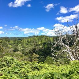
Well, girlfriend and I missed the left to go to the falls and wound up doing Aiea Loop Trail...I hiked it barefoot and with a backpack that had a gallon of water in it....trail was pretty muddy. She had on Nike's and I think we both did pretty well...after reading about the falls being dried up I'm glad we missed the turn. We found ourselves with a birds eye view of the H3 right before the entrance to the Harano tunnel. Additionally, we had several breathtaking view points along the way. We detoured off on a few stray paths which led to more beautiful views of the Koolau valleys which would be unviewable by any other method except helicopter. Not an easy hike, not a short one either... About 4 and a half hours round trip...

This isn't hiked as much as it was probably done in the past... pretty overgrown but the falls are amazing, we have had a lot of rain lately so the falls were flowing but it's been sunny for 2 days so the trail was fairly dry and not too muddy. Getting up to the ridge and finishing the loop was a challenge to say the least. The trail markers passed the falls are useless so have a good GPS and good shoes for the climb!
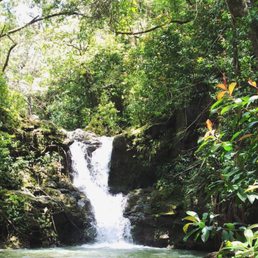

I was so stoked to find this trail! I hike the Aiea Loop a lot and it was getting boring. This is just as long as the Aiea Loop and took about the same amount of time. I loved that most of the hike is along a river. The waterfall at the end is gorgeous and the fact that there were no people there was even more awesome. If you happened to find this trail please don't litter!!! Even though this is a less visited trail we still found trash! Very disappointing! Mahalo!

The waterfall and stream were dried up when I went. I took the option where I went past the waterfall, took the path that goes parallel to the stream, eventually turned right (keep a close lookout for this turn; I initially missed it and was lost for a while), and headed up a steep long uphill to get back to the Aiea Loop trail. If you do this option, a bit of warning: there are pig carcasses next to the stream that smell bad and are creepy, especially if you get lost like I did. The views are very nice on the way back up to Aiea Loop trail, but I'd recommend just turning back the way you came after getting to the waterfall.

Thanks to watching a YouTube video by Not so good hikers, I was able to find the Kalauao Trail path along the Aiea Loop Trail. The beginning of the trail wasn't so bad until you take a 2nd right going down a very steep path and pass the marked 'wrong way' rock. Luckily, there are blue and pink markers that help guide you along the trail. We went with a couple of other people & our Bullterrier. They slipped & fell a few times and almost came close to twisting there ankles. Our dog was also struggling afew times too. The trail was very muddy & slippery. I thought it was dangerous as we came close to slipping on many of the rocks in & around the stream. Luckily, there was a rope, tree branches & rocks to help grab onto going down/up the trail. We were sad to reach the end of the trail & there was no waterfall! Going back up was much faster than going down but a bit of climbing is involved. We were now covered in mud & wet from the rain. It took us a little under 2 hours to do the entire trail. IMO I wouldn't bring my daughter or dog here on this trail again. Overall a good trail to do on a DRY day. I liked that the trail was shaded & well maintained. I recommend bringing a change of clothes, slippers/extra shoes, towel, hand sanitizer & water.

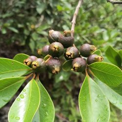
Did this hike today and I must say the waterfall was gorgeous! We went after a fairly heavy rainfall last night and pretty frequent rains throughout the week, because I have seen some picture of the dry water chute and we really didn't want to come across that scene. So from the beginning, you start out in Keaiwa State park in Aiea and begin the Aiea loop trail. After approx 5 minutes we came to the first lookout on the right and continued on the trail until the trail made a 'reverse S' and the first junction to start this trail was on the left. From here there were obvious ribbons and we went through eucalyptus trees and strawberry guava for approx 20 minutes until we came to a large mango tree (unfortunately the mango were not yet ripe) on the right with pink ribbons tied to it. This leads you to a trail basically going straight down a hill with roots that can be used for assistance. Due to this section, I would not recommend kids on this hike because it was quite muddy which can easily lead to a fall. After about 20 minutes going down the hill we were encountered by a plethora of Mountain Apple trees (don't worry about finding the perfect Apple just yet, there were thousands up and down the entire trail!) Then you encounter the stream, going upstream (right) you do several, I believe I counted 6 stream crossings before you reach the falls (approx 20 minutes.) DOnt worry so much about finding the correct stream crossing paths because as long as you stay close to the stream you won't get lost at this point. Atlast! You reach the beautiful waterfall! Due to the recent rains we did jump off the waterfall but it was actually fairly shallow. One person back at the falls jumped from the highest point- which I definitely do NOT recommend! We also saw several lilikoi along the trail. We decided to do this trail as a loop so we climbed up the falls and continued to follow the stream doing about 5 stream crossings again. You'll come to a Y in the trail and you want to stay to the right hand side. Then, approx 20 mins after leaving the waterfall you will take a discreet right hand turn on the trail, which was also marked with pink markers to go up the hill. This way seemed a lot more dangerous because it was muddier and you were scaling up a steep hill with limited things to grab onto, as opposed to the original trail down to the falls. Once you finally make it up the steep hill you realize you have to climb the ridge all the way around because you are on the complete opposite side of where you started. So the loop makes the hike back approximately twice as long, but it was a nice change of scenery. tips: bring mosquito repellent Go after it rains, you don't want to see a dry chute!

2 years ago
Looking for a short 4 mile hike with a beautiful waterfall at the end? Look no further, Kalauao Trail is part of the popular Aiea Loop trail and takes only about 2.5-3 hours. Park your car near the start of the trail and walk about .5 miles till you see a trail on the left covered on both sides by strawberry guava trees. Keep walking till you see pink ribbons hanging from the trees above you. You'll want to turn right here. http://www.yelp.com/user_local_photos?select=Nf_ogCW_vGLko3oWKLmTng&userid=QkQLnujuiBDP1mNChJYJww (Thanks Dan) You should see this orange ribbon on your left http://www.yelp.com/user_local_photos?select=huNI2tvliKP1sjx8wHTxKw&userid=QkQLnujuiBDP1mNChJYJww You'll soon be descending down the hill from hell. Now on to the hill from hell. It's not THAT bad, but it was muddy and there were roots sprouting up in every direction so be careful and go slow. It'll take you about 30 minutes to get down. http://www.yelp.com/user_local_photos?select=mLTAdXjWNIV8BZhED3RXXQ&userid=QkQLnujuiBDP1mNChJYJww There was only one section that had ropes. http://www.yelp.com/user_local_photos?select=snhj3FIcdmp8aFRVINpzmw&userid=QkQLnujuiBDP1mNChJYJww After what will seem like eternity, you will finally reach the stream.http://www.yelp.com/user_local_photos?select=dHtpVbsHrYu1eAWVRarNfg&userid=QkQLnujuiBDP1mNChJYJww Sorry folks, its going to take another 30 minutes till you get to your final destination but believe me its so worth it. You'll cross about 8 switchbacks all of which are clearly marked by ribbons. You are going to have to wade through the water so either wear vibrams or wear sneakers you don't mind getting wet. http://www.yelp.com/user_local_photos?select=LPdBrCREl84P3MAckOJ5HA&userid=QkQLnujuiBDP1mNChJYJww When you are about over walking through water and over rocks and getting eaten by mosquitoes you will finally be rewarded by this beautiful waterfall. http://www.yelp.com/biz_photos/kalauao-trail-aiea#AxO37IXkvNzmDNsOXUMQFw Lucky for us it had been raining for the past week so the waterfall was at full force. This is a nice alternative to Aiea Loop if you are looking for something a little more advanced. Definitely do it in the winter months when you can see the waterfall and make sure to wear bug repellent! read more


13 years ago
Great trail. I'm conflicted about posting this. There wasn't a soul on this trail. Had a waterfall to ourselves and I want to keep it that way. Trail is well-marked. If you can't find it, well, maybe it isn't for you. To do the loop you need more than a bottle of water and some sandals. You WILL get dirty. My dog did it. He had a harness/backpack which he needed to get a boost sometimes. Long, but not too long. Not TOO taxing. For those of you who would have trouble hiking for 4 hours going down and up over a 1000 ft, just stay on the Aiea loop. Oh, about the Aiea loop, I have a dog. He is well-behaved and trained. However even HE cannot pick up after himself. It takes a well-trained owner to keep this trail people and dog friendly. read more


Well, girlfriend and I missed the left to go to the falls and wound up doing Aiea Loop Trail...I hiked it barefoot and with a backpack that had a gallon of water in it....trail was pretty muddy. She had on Nike's and I think we both did pretty well...after reading about the falls being dried up I'm glad we missed the turn. We found ourselves with a birds eye view of the H3 right before the entrance to the Harano tunnel. Additionally, we had several breathtaking view points along the way. We detoured off on a few stray paths which led to more beautiful views of the Koolau valleys which would be unviewable by any other method except helicopter. Not an easy hike, not a short one either... About 4 and a half hours round trip... read more

5 years ago
The trail in was pretty easy but everything else was rough. It was muddy and slippery. The incline to get down and up was crazy steep. My legs were burning after. Very fun hike where you get to climb. Not an impressive waterfall since we haven't had any hard rains. read more


This isn't hiked as much as it was probably done in the past... pretty overgrown but the falls are amazing, we have had a lot of rain lately so the falls were flowing but it's been sunny for 2 days so the trail was fairly dry and not too muddy. Getting up to the ridge and finishing the loop was a challenge to say the least. The trail markers passed the falls are useless so have a good GPS and good shoes for the climb! read more


8 years ago
This hike was very tricky to find. Lol ! The hike was 5 hours to get to the waterfall there's a lot of crossing the stream because you have to follow the pink ribbons . My friend and I had the waterfall to ourselves and every walk to get to there was beautiful. read more


12 years ago
I was so stoked to find this trail! I hike the Aiea Loop a lot and it was getting boring. This is just as long as the Aiea Loop and took about the same amount of time. I loved that most of the hike is along a river. The waterfall at the end is gorgeous and the fact that there were no people there was even more awesome. If you happened to find this trail please don't litter!!! Even though this is a less visited trail we still found trash! Very disappointing! Mahalo! read more

11 years ago
The waterfall and stream were dried up when I went. I took the option where I went past the waterfall, took the path that goes parallel to the stream, eventually turned right (keep a close lookout for this turn; I initially missed it and was lost for a while), and headed up a steep long uphill to get back to the Aiea Loop trail. If you do this option, a bit of warning: there are pig carcasses next to the stream that smell bad and are creepy, especially if you get lost like I did. The views are very nice on the way back up to Aiea Loop trail, but I'd recommend just turning back the way you came after getting to the waterfall. read more


11 years ago
Thanks to watching a YouTube video by Not so good hikers, I was able to find the Kalauao Trail path along the Aiea Loop Trail. The beginning of the trail wasn't so bad until you take a 2nd right going down a very steep path and pass the marked 'wrong way' rock. Luckily, there are blue and pink markers that help guide you along the trail. We went with a couple of other people & our Bullterrier. They slipped & fell a few times and almost came close to twisting there ankles. Our dog was also struggling afew times too. The trail was very muddy & slippery. I thought it was dangerous as we came close to slipping on many of the rocks in & around the stream. Luckily, there was a rope, tree branches & rocks to help grab onto going down/up the trail. We were sad to reach the end of the trail & there was no waterfall! Going back up was much faster than going down but a bit of climbing is involved. We were now covered in mud & wet from the rain. It took us a little under 2 hours to do the entire trail. IMO I wouldn't bring my daughter or dog here on this trail again. Overall a good trail to do on a DRY day. I liked that the trail was shaded & well maintained. I recommend bringing a change of clothes, slippers/extra shoes, towel, hand sanitizer & water. read more


11 years ago
Did this hike today and I must say the waterfall was gorgeous! We went after a fairly heavy rainfall last night and pretty frequent rains throughout the week, because I have seen some picture of the dry water chute and we really didn't want to come across that scene. So from the beginning, you start out in Keaiwa State park in Aiea and begin the Aiea loop trail. After approx 5 minutes we came to the first lookout on the right and continued on the trail until the trail made a 'reverse S' and the first junction to start this trail was on the left. From here there were obvious ribbons and we went through eucalyptus trees and strawberry guava for approx 20 minutes until we came to a large mango tree (unfortunately the mango were not yet ripe) on the right with pink ribbons tied to it. This leads you to a trail basically going straight down a hill with roots that can be used for assistance. Due to this section, I would not recommend kids on this hike because it was quite muddy which can easily lead to a fall. After about 20 minutes going down the hill we were encountered by a plethora of Mountain Apple trees (don't worry about finding the perfect Apple just yet, there were thousands up and down the entire trail!) Then you encounter the stream, going upstream (right) you do several, I believe I counted 6 stream crossings before you reach the falls (approx 20 minutes.) DOnt worry so much about finding the correct stream crossing paths because as long as you stay close to the stream you won't get lost at this point. Atlast! You reach the beautiful waterfall! Due to the recent rains we did jump off the waterfall but it was actually fairly shallow. One person back at the falls jumped from the highest point- which I definitely do NOT recommend! We also saw several lilikoi along the trail. We decided to do this trail as a loop so we climbed up the falls and continued to follow the stream doing about 5 stream crossings again. You'll come to a Y in the trail and you want to stay to the right hand side. Then, approx 20 mins after leaving the waterfall you will take a discreet right hand turn on the trail, which was also marked with pink markers to go up the hill. This way seemed a lot more dangerous because it was muddier and you were scaling up a steep hill with limited things to grab onto, as opposed to the original trail down to the falls. Once you finally make it up the steep hill you realize you have to climb the ridge all the way around because you are on the complete opposite side of where you started. So the loop makes the hike back approximately twice as long, but it was a nice change of scenery. tips: bring mosquito repellent Go after it rains, you don't want to see a dry chute! read more


11 years ago
I'm only giving this three stars because it's a bit anti climatic to get to the end and only find a dry fall and small stagnant pool. I would rate this an intermediate hike because I did it with a 3 1/2 year old. He walked to the trail head and all the way down the hill (save for the last 25 feet or so), but needed to go in the pack for the entire rest of the hike. At 15 weeks pregnant, I tell ya, I was dying packing him back up that hill. Kill me now! I should add, my little one did koko head stairs and a slew of other hikes solo, so he's good with strenuous hikes, but this one was just too much. Only good thing about the falls being dry was it made crossing the stream a cinch. read more


12 years ago
8 years ago
More info about Kalauao Trail
99-1849 Aiea Heights Dr
Aiea, HI 96701
Directions
Hours
Outdoor Amenities
Ask the Community - Kalauao Trail
Review Highlights - Kalauao Trail


Kalauao Trail - hiking - Updated July 2026
Best of Aiea
People found Kalauao Trail by searching for…
Trending Searches in Aiea, HI
Blueberry Picking near Kalauao Trail
Cliff Jumping near Kalauao Trail
Cruising Spots near Kalauao Trail
Dog Friendly Things To Do near Kalauao Trail
Dog Swimming near Kalauao Trail
Flower Fields near Kalauao Trail
Kayak Rental near Kalauao Trail
Kids Activities Indoor near Kalauao Trail
Lookout Points near Kalauao Trail
Off Road Trails near Kalauao Trail
Outdoor Activities near Kalauao Trail
River Swimming near Kalauao Trail
Rock Quarry near Kalauao Trail
Scenic Overlook near Kalauao Trail
Sunrise View near Kalauao Trail
Swimming Holes near Kalauao Trail
Things To Do On A Rainy Day near Kalauao Trail
U Pick Farms near Kalauao Trail
Watch Sunset near Kalauao Trail
Browse Articles
Browse Nearby
BEST of Aiea, Hawaii Coffee near Kalauao Trail
BEST of Aiea, Hawaii Restaurants near Kalauao Trail
BEST of Aiea, Hawaii Things to Do near Kalauao Trail
BEST of Aiea, Hawaii Breakfast near Kalauao Trail
BEST of Aiea, Hawaii Walking Trails near Kalauao Trail
BEST of Aiea, Hawaii Parks near Kalauao Trail
BEST of Aiea, Hawaii Campgrounds near Kalauao Trail
Browse Brands
Related Searches in Aiea, HI
Best Dog Hiking Trails Around Aiea, Hawaii
Best Fishing Locations and Guides in Aiea, Hawaii
Best Nature Trails for Hiking in Aiea, Hawaii
Best Places for Horseback Riding in Aiea, Hawaii
Best Sightseeing Experiences Available in Aiea, Hawaii
Best Waterfalls and Swimming Holes in Aiea, Hawaii
Discover Dog Friendly Trails to Explore in Aiea, Hawaii
Discover Easy Hiking Trails Near Aiea, Hawaii
Discover Kid Friendly Hiking Trails in Aiea, Hawaii
Discover Popular Bike Trails in Aiea, Hawaii
Discover Scenic Mountain Bike Trails Near Aiea, Hawaii
Discover Top Nature Parks to Visit in Aiea, Hawaii
Discover Walking Parks in Aiea, Hawaii Near You
Discover a Hiking Trail in Aiea, Hawaii
Discover the Best Night Hike Trails in Aiea, Hawaii
Dog-Friendly Hikes With Dogs in Aiea, Hawaii
Enjoy Camping Adventures Around Aiea, Hawaii
Enjoy Kayaking Adventures in Aiea, Hawaii
Enjoy Off Leash Dog Hikes in Aiea, Hawaii
Enjoy Tent Camping Spots Around Aiea, Hawaii
Enjoy a Beautiful Waterfall Hike in Aiea, Hawaii
Enjoy the Best Walking Path in Aiea, Hawaii
Enjoy the Best Walking Trails in Aiea, Hawaii
Explore Easy Hikes Perfect for All in Aiea, Hawaii
Explore Fun Activities to Do in Aiea, Hawaii
Explore Popular Campgrounds Near Aiea, Hawaii
Explore Popular State Park Destinations in Aiea, Hawaii
Explore Top Dog Parks in Aiea, Hawaii Near You
Explore the Best Beach Spots in Aiea, Hawaii
Family Friendly Hiking With Kids in Aiea, Hawaii
Find Cozy Camping Cabins in Aiea, Hawaii
Find Popular Ziplining Spots Around Aiea, Hawaii
Find Top Dog Friendly Parks to Visit in Aiea, Hawaii
Find Top-Rated Waterfalls in Aiea, Hawaii Now
Find the Best Parks for Picnics in Aiea, Hawaii
Hiking Trails With Waterfalls in Aiea, Hawaii
Off Leash Dog Hiking Trails in Aiea, Hawaii
Picnic Areas With BBQ Pits Available in Aiea, Hawaii
Popular Outdoor Activities to Try in Aiea, Hawaii
Popular Picnic Spots to Visit in Aiea, Hawaii
Popular Waterfall Hiking Trails in Aiea, Hawaii
Safe and Fun Parks for Kids in Aiea, Hawaii
Top Hiking Trails to Explore in Aiea, Hawaii
Top Playgrounds for Kids to Enjoy in Aiea, Hawaii
Top Running Trails to Explore in Aiea, Hawaii
Top Swimming Spots and Pools in Aiea, Hawaii
Top Things to Do With Kids in Aiea, Hawaii
Top-Rated Camping Sites in Aiea, Hawaii


