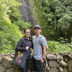
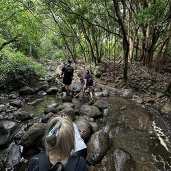
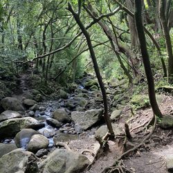
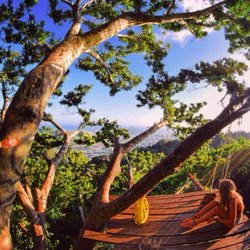
Makiki Valley Trail Photos


You might also consider
More like Makiki Valley Trail
Recommended Reviews - Makiki Valley Trail
Start your review...

Reviews With Photos


This is one of my favorite hikes. Located at the Nature Center in Makiki. There is a little parking lot and a bathroom at the beginning of the trail. This is the only bathroom on the whole trail. The hike takes about an hour and a half if you go at an enjoyable speed. It is about 3 miles long. At the beginning of the hike, you can choose to go either left or right (it's a loop). Going left starts off easy and is a slow incline uphill half way and downhill is steep, so it can he hard on knees. If you go right, it's hard in the beginning because it's a steep uphill but the other half is an enjoyable downhill. I have done both. I prefer going right and having it harder first. Bring water, a hat, wear sunscreen and mosquito repellent. It will get muddy if it's been raining, so plan to have your shoes get dirty (adds to the fun).

I've hiked this trail a few times and have enjoyed it each visit. On All Trails it's called Makiki Valley Loop. Trail can be hiked clockwise or counter clock wise. Counter clockwise does all the climbing at the beginning up a very root covered trail. Some people might prefer a more gradual climb. The trail takes you through a lush rainforest that follows a creek. You will hear many birds singing, pick some wild guava and may even see a wild pig. The trail does cross over a few other trails so you my want to check out All Trail to stay on loop. It's rated Intermediate, can be muddy after rain.

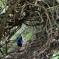
TL,DR: Map. Mud. MOSQUITOES. ***Helpful Tips noted with asterisks*** The Makiki Valley Trail is connected to a few different trails (Kanealole, Maunalaha, 'Ualaka'a, Moleka, Nahuina) and roads (Tantalus Road, Round Top Drive). Somewhere along Tantalus Road and Round Top Drive, the roads were closed to vehicle traffic. A sign said to turn around. It was open for foot traffic. We asked someone from the area and they said the roads were closed about a year ago due to land slides. Usually you'd be able to go all the way around by car. Input "Hawaii Nature Center" into Google Maps to find it. From the Hiker Parking Lot area, we walked through the Makiki Arboretum. This was a nice stroll on flat ground. About .4 miles according to the map. When passing the Hawaii Nature Center there are restrooms and a water fountain before the bridge. I really liked the informational signs posted along the restroom walls about Malama Hawaii and the history of Makiki Valley Watershed. ***There is a very useful map, the "Tantalus Trailway Map" in the beginning. With a QR code to different maps to help with the hike. Here's the link: https://www.tantalustrailway.org/download/ *** Shout out to the friendly Hiker that told us about the QR code on this map. I used the interactive map to track our hike/ give me motivation by looking at how much was left until we finished (LOL but forreal). Here's that one: https://www.tantalustrailway.org/dofaw/index.htm You can click the location triangle on the top right to see where you are on the trail. Disclaimer: I'm not that fit... I'm heavily into om nomzing while I Netflix/ YouTube/ Hulu and chill with the cat boyz. I made sure to prep my lungs for this hike with some puffs from my asthma inhaler (the real MVP!). We opted to explore the "Makiki Valley Loop Trail", this connects 3 trails Kanealole, Makiki Valley and Maunalaha. According to the map, .8 miles, .8 miles, and .75 miles. All together 2.35 miles. This hike took us about 3 hours (11:52am to 3pm) to complete. We were going at a comfortable walking pace. It was Sunday and there were quite a few other people we passed along the way. Not Diamond Head kind of busy, but this seems like a pretty popular hike. People brought their dogs, their babies strapped to them and grown kids. Some people were also jogging through the hike. After you cross the bridge, Kanealole is on the left side and Maunalaha is on the right side. We started with Kanealole. The forest was pretty dense, so most of it was in the shade. I didn't make use of my sunglasses like I thought I would. It was pretty muddy and slippery. ***Shoes with good grip would be helpful. And so would wearing clothes you wouldn't mind getting dirty.*** There was lots of weaving through tree roots, rocks in shallow water and tall grass. Due to the proximity to water sources (Makiki, Kanealole, and Moleka Streams), the mosquitoes here were abundant and never ending. ***Bug spray is highly recommended.*** 3 big striped mosquitos landed on my right hand while I was tying my shoelaces. They're vicious here!!! The view was pretty forest. Lotsa trees, bushes, vines, fungi, grass, running streams, and kalo. The inclines were steady and in succession. I did have to take "imaginary binocular" scenic breaks to catch my breath and drink water/ find motivation/ pray. My friend really thought ahead and planned well. She had all the snackies. Beef jerky sticks, almonds, and strawberry sour belts. Thanks for keeping me alive friend :D I was so relieved to finally see that we finished the Kanealole section and made it to the Makiki Valley portion. This is point A on the map. There was a variation of some flat ground with inclines. Views were of mountains and more forest. This area was a bit drier than Kanealole and there was more sunlight. At the end of this Makiki Valley section at point B on the map, the trail branches into 'Ualaka'a, more Makiki Valley and Maunalaha. The Maunalaha section was the driest out of the 3, but was also waaay steeper. Definitely wider climbing steps, stretch those hammys. Lotsa sunlight came through the pine trees. There view included mountains and a glimpse of the cityscape. The tree roots were endless and all tangled. I held onto trees and branches. At this point my legs were shaking in protest from all the strenuous hiking. Looking back I liked that we did the steeper side last as a decline. Our hike went gradually in difficulty instead of starting off difficult. I appreciated building towards that. Though to each their own, some people started Kanealole and then went back around. Others started from Maunalaha and ended through Kanealole. Depends on the person and their fitness levels. Be prepared. And happy nature hiking! :D

This is a truly beautiful trail. There are some areas that have plants labeled like a botanical garden. If you follow the loop, it's about a 3.5-4 mile walk through lush island jungle. There is a section where the tree vines drape over the whole valley. It's a super amazing place. The hike itself is moderate with only a few areas of steepness. I have brought a lot of guests here. I've hiked it pregnant. My husband has hiked it barefoot. No issues. There are chameleons that live here. They're hard to spot, obviously, but so cool to see. Please don't try to make them into pets.

This is a really nice, introductory hike on the island. It's not too difficult, depending on your fitness level, and it's well traversed with plenty of shade. There are restrooms near the parking lot that shares an area with a Nature Center. Went on a Tuesday morning and the summer camp kids were out and having a blast at the Center. The loop is a little over two miles. If you enter from the west side, it's pretty easy for the first quarter mile or so. The rest is all uphill and you'll get a good leg workout. Again, very well canopied with lots of fauna, streams, and a few bridges. A very nice botanical experience. If you enter from the east side, it's a lot harder, in my opinion. All uphill and drier, with rooted paths and lots of rocks. It's a good workout from that side. At midpoint, you'll see some signage of the whole Tantatulus trail system. You can enter that system by going up to the left to the Moleka trail, and another two miles you'll be at the Manoa cliffs. You can go further up for miles. Didn't have time or energy for that. Maybe some other day.

Wear good hiking shoes that you don't mind getting mud on. Be careful where it is wet as it will be slippery. Also probably mosquito repellant good idea, don't be like me and become a walking buffet for those guys. At least 1L of water a d set of dry socks after you wash your shoes at the end. Otherwise really cool hike, lots of unique vegetation. Not a hike for beginners or kids as some steps are pretty high. Good luck!

To end the warm and sunny Memorial Day weekend, we went to the Makiki Valley Trail. Being a trail, it feels more like a comfortable hike for the non-hiker. Throughout the trails roots, and rocks create a pathway that leads to streams. As we walk around the path, we encounter two bridges which cross over the streams. The bridges form a romantic backdrop to the vast nature found around the trail. This hike makes for a perfect hike for all. Families bring their children on this hike. Elderly people hike here with their friends and they use the hiking poles. An added plus: people can bring their dogs to this trail. When we finished our hike, a local woman said that the hike extends over to the mountains. She brings her 10 year old dog up the mountain so they can see below. Come and enjoy a lovely hike at the Makiki Valley Trail. Bring family, a date, or friends here.

All the elements of a lovely nature hike are here: the trees, the streams, the serenity. We enjoyed this trail immensely for its beauty as well as providing a terrific cardio workout. The first part of the loop takes you over a couple of pedestrian bridges and past streams with the relaxing sounds of babbling brooks. There is an incline for most of this part and I highly recommend wearing hiking boots or trail shoes to help you navigate the bigger rocks and lots of exposed tree roots along the way. There was a light rain before we headed out on our trek, so parts of the trail were slippery, especially the rocks with moss; the correct footwear will assist you with traction in either dry or wet conditions. The trees provide lots of shade so I could see this being especially popular in the warmer months. We didn't encounter too many other hikers which I loved. Overall, a really satisfying time in nature.

Nice shaded trail! This is rated as "moderate" on AllTrails which I think is accurate. The information guide says this is 3.2mi, 950ft elevation gain. It took me about an hour and a half to complete going in the counter clockwise direction. The first leg of the loop, the Maunahala trail, was an upwards incline all the way with a bunch of tree roots on the ground that made the ground stable. But sometimes the roots require a big step up. Children may have a tough time here. It's wide so you can catch a break off to the side if needed. No muddy/slippery parts. The second and third leg of the loop, the Makiki Valley and Kanalole trails, were mostly downhill. There were muddy/slippery parts here where it was close to the streams. I had to use my hands to balance myself while climbing down rocks a few times. I slipped a few times but was able to catch myself with my other foot before falling. I was focused in on the ground during this section so didn't get to take in the forest! Guess I'm partially to blame since I was using running shoes! It started showering right as I was finishing my hike, so I'm glad I just missed the rain during these parts. Like other hiking spots, be prepared to bring water and hiking shoes. I'm not sure which direction would be the easiest for this loop. If you go clockwise, you'll be going uphill for a longer time, and face muddy conditions, but it won't be as steep. There's no great views on this trail but you'll be surrounded and shaded by nature the whole way. There's a small botanical garden at the start of the loop too! The (free) parking lot got full by 10am but you can park along the street. There are bathrooms/water fountains next to the nature center at the beginning of the loop. I don't think this is a must-do trail if you are visiting Hawaii but is a nice mix up for locals.

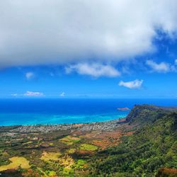
Crazy hike! I thought it'll be easy but this hike was about 3 hours long! Beginning of the trail was easy until it got steep and it was getting harder to hike. Then in the middle it started to get all muddy and slippery! Didn't expect it to be a little tricky going down cuz all the tree roots and the moss on the rocks! If this is your first time I recommend wearing shoes you don't mind getting dirty, wear clothes that you don't mind getting dirty and also bring mosquito repellent if you don't like to get bitten! There's a lot of red ants on the floor so don't sit on the floor or the benches during the hike! There's no sun coming in the valley so you don't have to wear sunscreen. There's barely any sun coming in since all the trees block it. In general the hike was fun! Seeing nature and just being in fresh air. Just felt really great! The view was amazing! You can see town from the middle of the trail!

Definitely a harder hike if you have littles or baby wearing! Went in the morning around 9am and followed the instructions to park by the nature center or on the road and to start by going left as the incline would be gradual. This was a good idea until we started our decent and the other side was all webbed tree roots. It was much more difficult going down while baby wearing and it was challenging for our toddler. Overall, it was a really good hike. A little under 4 miles for the loop and it was mostly shaded. Log you have hiking boots wear them and walking sticks would definitely be helpful going up and down. Bug spray is a must as well. I think if we go again, we'll try to go right first.

This is a great hike and a good one if you want to get off the COVID couch. A loop trail with a stream, waterfalls and it seemed a neverending incline. A little muddy but not bad and surprisingly no swarms of mosquitoes. The native plants at the start of the hike set a tone for all the amazing flora along the hike. The loop is two hikes connected and at one point youll see another branch of another trail. We will give that a try next time.

4 months ago
This hike going clockwise from the start is great because you begin with some moderate uphills but nothing too wild, and then you end with some downhills over aerial roots while the people going counter-clockwise are just starting to scramble up those roots. There are some beautiful sections with huge ferns. The trail is often very quiet and you hear lots of birdsong. I do recommend hiking shoes and maybe even a walking stick (I got plenty of use out of my mine to get over some of the rocks and roots). A little over 3 miles so you feel like you got a good hike in, but it's not too crazy. read more
 of the hike. - Hiking Near Me - Honolulu, Hawaii")
I really love this trail. It's quite easy with enough kick to make you feel like you've had full hike. There are small streams, bird wildlife, and waterfalls that makes this feel a little bit like a botanical garden. Parking can get packed during the weekends so come early. read more

This trail is part is a larger group of called the "Tantalus trails". We have hike many parts of the Tantalus but I have never got to hike this full loop. We decide to turn right at the slip going clockwise. Which to me is the hard way. But I liked the challenge. This trail does have places you have to cross creeks, and can be muddy. Also, roots are everywhere so please watch your step. Rocks to climb, step over, and have to scale up or down depending on the way you go. The water fall if so gorgeous and be careful if you take the off shoot trail to it. The rocks around it are super slippery. We love this trail system and have enjoyed all of our hikes on it! Last thing, wear your bug repellent! You will need it. read more


5 months ago
1 year ago
Hiking can be dangerous if you walk the dead-end or you get Lost good thing you Bring a friend or a Buddy with you good to try fruits on a tree good view at the waterfall Good Photo to take Hiking can really Let Me Lose weight and sweat read more


3 years ago
This is one of my favorite hikes. Located at the Nature Center in Makiki. There is a little parking lot and a bathroom at the beginning of the trail. This is the only bathroom on the whole trail. The hike takes about an hour and a half if you go at an enjoyable speed. It is about 3 miles long. At the beginning of the hike, you can choose to go either left or right (it's a loop). Going left starts off easy and is a slow incline uphill half way and downhill is steep, so it can he hard on knees. If you go right, it's hard in the beginning because it's a steep uphill but the other half is an enjoyable downhill. I have done both. I prefer going right and having it harder first. Bring water, a hat, wear sunscreen and mosquito repellent. It will get muddy if it's been raining, so plan to have your shoes get dirty (adds to the fun). read more


I've hiked this trail a few times and have enjoyed it each visit. On All Trails it's called Makiki Valley Loop. Trail can be hiked clockwise or counter clock wise. Counter clockwise does all the climbing at the beginning up a very root covered trail. Some people might prefer a more gradual climb. The trail takes you through a lush rainforest that follows a creek. You will hear many birds singing, pick some wild guava and may even see a wild pig. The trail does cross over a few other trails so you my want to check out All Trail to stay on loop. It's rated Intermediate, can be muddy after rain. read more


3 years ago
TL,DR: Map. Mud. MOSQUITOES. ***Helpful Tips noted with asterisks*** The Makiki Valley Trail is connected to a few different trails (Kanealole, Maunalaha, 'Ualaka'a, Moleka, Nahuina) and roads (Tantalus Road, Round Top Drive). Somewhere along Tantalus Road and Round Top Drive, the roads were closed to vehicle traffic. A sign said to turn around. It was open for foot traffic. We asked someone from the area and they said the roads were closed about a year ago due to land slides. Usually you'd be able to go all the way around by car. Input "Hawaii Nature Center" into Google Maps to find it. From the Hiker Parking Lot area, we walked through the Makiki Arboretum. This was a nice stroll on flat ground. About .4 miles according to the map. When passing the Hawaii Nature Center there are restrooms and a water fountain before the bridge. I really liked the informational signs posted along the restroom walls about Malama Hawaii and the history of Makiki Valley Watershed. ***There is a very useful map, the "Tantalus Trailway Map" in the beginning. With a QR code to different maps to help with the hike. Here's the link: https://www.tantalustrailway.org/download/ *** Shout out to the friendly Hiker that told us about the QR code on this map. I used the interactive map to track our hike/ give me motivation by looking at how much was left until we finished (LOL but forreal). Here's that one: https://www.tantalustrailway.org/dofaw/index.htm You can click the location triangle on the top right to see where you are on the trail. Disclaimer: I'm not that fit... I'm heavily into om nomzing while I Netflix/ YouTube/ Hulu and chill with the cat boyz. I made sure to prep my lungs for this hike with some puffs from my asthma inhaler (the real MVP!). We opted to explore the "Makiki Valley Loop Trail", this connects 3 trails Kanealole, Makiki Valley and Maunalaha. According to the map, .8 miles, .8 miles, and .75 miles. All together 2.35 miles. This hike took us about 3 hours (11:52am to 3pm) to complete. We were going at a comfortable walking pace. It was Sunday and there were quite a few other people we passed along the way. Not Diamond Head kind of busy, but this seems like a pretty popular hike. People brought their dogs, their babies strapped to them and grown kids. Some people were also jogging through the hike. After you cross the bridge, Kanealole is on the left side and Maunalaha is on the right side. We started with Kanealole. The forest was pretty dense, so most of it was in the shade. I didn't make use of my sunglasses like I thought I would. It was pretty muddy and slippery. ***Shoes with good grip would be helpful. And so would wearing clothes you wouldn't mind getting dirty.*** There was lots of weaving through tree roots, rocks in shallow water and tall grass. Due to the proximity to water sources (Makiki, Kanealole, and Moleka Streams), the mosquitoes here were abundant and never ending. ***Bug spray is highly recommended.*** 3 big striped mosquitos landed on my right hand while I was tying my shoelaces. They're vicious here!!! The view was pretty forest. Lotsa trees, bushes, vines, fungi, grass, running streams, and kalo. The inclines were steady and in succession. I did have to take "imaginary binocular" scenic breaks to catch my breath and drink water/ find motivation/ pray. My friend really thought ahead and planned well. She had all the snackies. Beef jerky sticks, almonds, and strawberry sour belts. Thanks for keeping me alive friend :D I was so relieved to finally see that we finished the Kanealole section and made it to the Makiki Valley portion. This is point A on the map. There was a variation of some flat ground with inclines. Views were of mountains and more forest. This area was a bit drier than Kanealole and there was more sunlight. At the end of this Makiki Valley section at point B on the map, the trail branches into 'Ualaka'a, more Makiki Valley and Maunalaha. The Maunalaha section was the driest out of the 3, but was also waaay steeper. Definitely wider climbing steps, stretch those hammys. Lotsa sunlight came through the pine trees. There view included mountains and a glimpse of the cityscape. The tree roots were endless and all tangled. I held onto trees and branches. At this point my legs were shaking in protest from all the strenuous hiking. Looking back I liked that we did the steeper side last as a decline. Our hike went gradually in difficulty instead of starting off difficult. I appreciated building towards that. Though to each their own, some people started Kanealole and then went back around. Others started from Maunalaha and ended through Kanealole. Depends on the person and their fitness levels. Be prepared. And happy nature hiking! :D read more


 - Hiking Near Me - Honolulu, Hawaii")


This is a truly beautiful trail. There are some areas that have plants labeled like a botanical garden. If you follow the loop, it's about a 3.5-4 mile walk through lush island jungle. There is a section where the tree vines drape over the whole valley. It's a super amazing place. The hike itself is moderate with only a few areas of steepness. I have brought a lot of guests here. I've hiked it pregnant. My husband has hiked it barefoot. No issues. There are chameleons that live here. They're hard to spot, obviously, but so cool to see. Please don't try to make them into pets. read more


5 years ago
This is a really nice, introductory hike on the island. It's not too difficult, depending on your fitness level, and it's well traversed with plenty of shade. There are restrooms near the parking lot that shares an area with a Nature Center. Went on a Tuesday morning and the summer camp kids were out and having a blast at the Center. The loop is a little over two miles. If you enter from the west side, it's pretty easy for the first quarter mile or so. The rest is all uphill and you'll get a good leg workout. Again, very well canopied with lots of fauna, streams, and a few bridges. A very nice botanical experience. If you enter from the east side, it's a lot harder, in my opinion. All uphill and drier, with rooted paths and lots of rocks. It's a good workout from that side. At midpoint, you'll see some signage of the whole Tantatulus trail system. You can enter that system by going up to the left to the Moleka trail, and another two miles you'll be at the Manoa cliffs. You can go further up for miles. Didn't have time or energy for that. Maybe some other day. read more


2 years ago
Wear good hiking shoes that you don't mind getting mud on. Be careful where it is wet as it will be slippery. Also probably mosquito repellant good idea, don't be like me and become a walking buffet for those guys. At least 1L of water a d set of dry socks after you wash your shoes at the end. Otherwise really cool hike, lots of unique vegetation. Not a hike for beginners or kids as some steps are pretty high. Good luck! read more


To end the warm and sunny Memorial Day weekend, we went to the Makiki Valley Trail. Being a trail, it feels more like a comfortable hike for the non-hiker. Throughout the trails roots, and rocks create a pathway that leads to streams. As we walk around the path, we encounter two bridges which cross over the streams. The bridges form a romantic backdrop to the vast nature found around the trail. This hike makes for a perfect hike for all. Families bring their children on this hike. Elderly people hike here with their friends and they use the hiking poles. An added plus: people can bring their dogs to this trail. When we finished our hike, a local woman said that the hike extends over to the mountains. She brings her 10 year old dog up the mountain so they can see below. Come and enjoy a lovely hike at the Makiki Valley Trail. Bring family, a date, or friends here. read more


All the elements of a lovely nature hike are here: the trees, the streams, the serenity. We enjoyed this trail immensely for its beauty as well as providing a terrific cardio workout. The first part of the loop takes you over a couple of pedestrian bridges and past streams with the relaxing sounds of babbling brooks. There is an incline for most of this part and I highly recommend wearing hiking boots or trail shoes to help you navigate the bigger rocks and lots of exposed tree roots along the way. There was a light rain before we headed out on our trek, so parts of the trail were slippery, especially the rocks with moss; the correct footwear will assist you with traction in either dry or wet conditions. The trees provide lots of shade so I could see this being especially popular in the warmer months. We didn't encounter too many other hikers which I loved. Overall, a really satisfying time in nature. read more


4 years ago
Nice shaded trail! This is rated as "moderate" on AllTrails which I think is accurate. The information guide says this is 3.2mi, 950ft elevation gain. It took me about an hour and a half to complete going in the counter clockwise direction. The first leg of the loop, the Maunahala trail, was an upwards incline all the way with a bunch of tree roots on the ground that made the ground stable. But sometimes the roots require a big step up. Children may have a tough time here. It's wide so you can catch a break off to the side if needed. No muddy/slippery parts. The second and third leg of the loop, the Makiki Valley and Kanalole trails, were mostly downhill. There were muddy/slippery parts here where it was close to the streams. I had to use my hands to balance myself while climbing down rocks a few times. I slipped a few times but was able to catch myself with my other foot before falling. I was focused in on the ground during this section so didn't get to take in the forest! Guess I'm partially to blame since I was using running shoes! It started showering right as I was finishing my hike, so I'm glad I just missed the rain during these parts. Like other hiking spots, be prepared to bring water and hiking shoes. I'm not sure which direction would be the easiest for this loop. If you go clockwise, you'll be going uphill for a longer time, and face muddy conditions, but it won't be as steep. There's no great views on this trail but you'll be surrounded and shaded by nature the whole way. There's a small botanical garden at the start of the loop too! The (free) parking lot got full by 10am but you can park along the street. There are bathrooms/water fountains next to the nature center at the beginning of the loop. I don't think this is a must-do trail if you are visiting Hawaii but is a nice mix up for locals. read more


2 years ago
2 years ago
6 years ago
Crazy hike! I thought it'll be easy but this hike was about 3 hours long! Beginning of the trail was easy until it got steep and it was getting harder to hike. Then in the middle it started to get all muddy and slippery! Didn't expect it to be a little tricky going down cuz all the tree roots and the moss on the rocks! If this is your first time I recommend wearing shoes you don't mind getting dirty, wear clothes that you don't mind getting dirty and also bring mosquito repellent if you don't like to get bitten! There's a lot of red ants on the floor so don't sit on the floor or the benches during the hike! There's no sun coming in the valley so you don't have to wear sunscreen. There's barely any sun coming in since all the trees block it. In general the hike was fun! Seeing nature and just being in fresh air. Just felt really great! The view was amazing! You can see town from the middle of the trail! read more


5 years ago
Definitely a harder hike if you have littles or baby wearing! Went in the morning around 9am and followed the instructions to park by the nature center or on the road and to start by going left as the incline would be gradual. This was a good idea until we started our decent and the other side was all webbed tree roots. It was much more difficult going down while baby wearing and it was challenging for our toddler. Overall, it was a really good hike. A little under 4 miles for the loop and it was mostly shaded. Log you have hiking boots wear them and walking sticks would definitely be helpful going up and down. Bug spray is a must as well. I think if we go again, we'll try to go right first. read more

This is a great hike and a good one if you want to get off the COVID couch. A loop trail with a stream, waterfalls and it seemed a neverending incline. A little muddy but not bad and surprisingly no swarms of mosquitoes. The native plants at the start of the hike set a tone for all the amazing flora along the hike. The loop is two hikes connected and at one point youll see another branch of another trail. We will give that a try next time. read more


5 years ago
It took me about 90 mins to finish. Great loop hiking with 3 trails. Didn't get any issue finding my way as a first timer. The map gives an accurate detail of how long it will take for each trail as well as the distance. I would do it again. A special "thank you" to everyone who contributed to build these hike trails and make it easy for first timer. read more

4 years ago
3 years ago
Pressed for time but want to squeeze in a quick hike, trail run or walk? This place is for you! It's a hop and a skip from anywhere in town. Just head up Makiki Street, veer to the left at the pumping station, and you'll come upon the parking area. After a short 5 minute walk up the road, you'll arrive at the start. This trail is clearly delineated and maintained very well. It's great for non-hikers and novices. You won't get the killer views that you can get on other hikes, but you'll get to see a lot of foliage, native hawaiian plants, etc. One of the nice things about all the foliage and trees is that it creates a lot of shade. And if it starts to rain, don't worry because the trees will afford some protection - just take cover under one of these: http://www.yelp.com/biz_photos/makiki-valley-loop-trail-honolulu?select=2KVmlnhhkbYmjPw7zACcyQ#f1bKx29ltymx6khd83Dr5A At the base of the trail, there are bathrooms and a water station for rinsing off your shoes before/after the hike. The shortest trail is 2.5 miles. You have the option of veering onto other side trails if you want a longer hike. This trail is pet, kid, and elderly friendly! read more


I usually prefer waterfall hikes, but this loop trail is such a fun hike that I highly recommend it for those who want a to squeeze a mini workout into their day. Hawaii has so many beautiful hikes to offer so if you find yourself wanting to try new loop trail hikes I would definitely recommend coming here. Parking can be a bit rough as they have a pretty small parking lot. I ended up parking on the side of the road and was fine. I recommend bringing mosquitoes repellent since there's so many as you are hiking by a stream. The hike itself can be muddy, but there is a foot wash station by the bathrooms so you can rinse off the mud there. I also recommend bringing an extra pair of slippers for the car so that way you can keep your muddy/wet shoes in a plastic bag after the hike. There is also a picnic table by the restrooms if you want to picnic before/after the hike. The hike itself took about 2 hours roundtrip. Our group consisted of two teenagers, me in my mid-20s and my aunties and uncles (in their mid-50s). We were all fine and none of us needed to take much breaks. There isn't much incline/decline on the hike, but the mud does make it slippery so watch out for that. The hike is filled with plants, green scenery, and goes alongside a stream at certain points so that was beautiful. What's a bit confusing is that there are different trails so I'm not 100% but we may have also done part of the Kanealole trail. We came here on christmas and this trail wasn't overly crowded at all. I saw some families bring their pups, so i believe it is also dog friendly. Overall I think this trail is good for all level hikers and is a family and dog friendly trail! read more


One of the more strenuous yet fun hikes I've done. It's on the road to tantalus but instead of going straight, you'll turn left towards the nature center. There's a little parking spot for cars as well. It was very shady hike, similar to a Manoa falls combine with the St. Louis hike. Lots of different terrains and lots of wonderful sights. The first half is absolutely brutal, get like we were going uphill for a straight 30 minutes. And just when you think there couldn't be any more uphill, you get more of that goodness. The second part of the loop was smooth sailings with most of it being downhill. There were parts that were very wet so watch your step! The best part about the hike was that you're pretty much covered in the shade the whole time so it wasn't that bad. Can't imagine going uphill while it's sunny. If you're looking for a challenge and want to sweat out the all you can eat bbq like we did, give this a try! read more
 - Hiking Near Me - Honolulu, Hawaii")
Working in an office job is DANGEROUS. Why? You gain weight so easily since you are sitting down for 8 hours every day. This is why I need to be more active and have been (trying) to run, walk, or hike at least every day. I haven't gone hiking for over a year, but have been on the look out for a new trail to explore. I found this trail through Yelp. It is convenient since the trail is in town and has parking for hikers. The path is easy to follow, so very little chance of getting lost. The incline/decline is not too steep. Plus, the path is pretty wide at most parts, so easy to walk around slower hikers or faster hikers can easily walk around you. There is not a lot of scenery, more plants and foliage. While you can start to feel like you are in the jungle, it is still pretty close to town because I could still hear motorcycles and cars driving by. Words of caution: while the plants provide a lot of shade and coverage from sun and/or rain, it also keeps the place nice and muddy. Some parts can be very sticky with puddles of muddy water that you can possibly step in and end up causing you to slip and fall later on. Overall, it is a relatively easy trail, but it can be challenging with all of the mud, slippery rocks and roots, and just the roots of trees sticking out from the ground. Notes: - There are other side trails that you can go on to make the hike longer. Maybe, when I get more adventurous and fit, I will explore the side trails. - Dogs are welcome to go hiking on this trail too! I saw at least 3 dogs when I went. read more


Reading the reviews made this loop trail seem easy peasy as we were pressed for time on Easter Sunday and wanted to squeeze in a quick hike. We knew it was a little over 2.5 miles in length and we read if we went clockwise on the trail, it'd be a little easier. We didn't realize the trail would be uphill for the majority of the first 2 miles. I guess I was thinking, flat-and-easy and not out-of-breath-climb. After that, it's downhill but be careful there are a lot of slippery rock areas and you are really close to the edge. It took us about 1hr and 20 minutes to complete the trail and we felt it was a good workout. We put in the Hawaii Nature Center in the GPS to find the park's parking lot. It's a short walk to the Nature Center (past the green gate) where you will find bathrooms before the trail head. I read that this trail is kid friendly, but it definitely depends on your kid. I think for the most part, don't expect the little ones to be able to complete this on their own or at least make sure you allot ample time to complete the trail. read more


Start by the Nature Center (i think) and then start the hike just behind it over a small wodden bridge, hiking in the woods. You are really hiking among the trees and up the hill. We went when it hasn't rained too much, so it was fairly dry and nice condition. There are trail maps on the trail for you to confirm your position and see what are the different trails you could take. At the first trail map, we took a right down the valley which went around and eventually led us back to Nature center where there are signs to help us learn about the different native Hawaiian plants. I guess next time, I should try this side first so I know more of what trees or plants I am passing by during my hike. There are also a couple waterfalls too off track a little bit. It could be slightly muddy on some parts. Apparently the local girl scout or other groups come for their hikes/bonding experience as well. read more


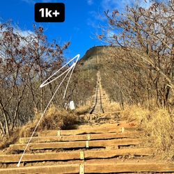
I don't often review trails on Yelp, however I do notice those that do often say "EASY" hike. Well, I don't know where you folks are getting your fitness, but I want some of that! I mean what is exactly HARD to you? A trail that could literally kill you?! This trail is NOT EASY in my book, especially if you do the loop counterclockwise, as the uphill treck is full of "stairmaster" portions that will challenge your quads and lungs for sure! Think Koko Crater trail, albeit, instead of railroad ties with stretched out strides, you're climbing cumbersome thick tree roots. Located near the bottom of Tantalus Drive, the Makiki Valley Loop Trail is interconnected with a WHOLE bunch of other trails that span the Koolau Mountains, however the loop itself is comprised of three main trails: Maunalaha Trail (.7 miles), Makiki Valley Trail (1.1 miles) and Kanealole Trail (.7 miles), for a total of 2.5 miles for three three combined. Estimated time to complete the loop and return to the trail head is about 1 1/2 to 2 1/2 hours. There isn't much scenery outside of the trail itself, except for a nice view of the mountainside of Makiki Valley, as well as a birdseye view of Honolulu City. There's also not as much diverse fauna as, say, the Manoa Valley Falls Trail. Still, it's pretty neat, and amazing how such a remote, untouched, deep forest landscape can be found just minutes from the busy streets of Honolulu. The trail can be a little confusing if there's no one else there to help guide the way, however you'll figure it out by the beaten path. There's a couple small streams to cross that should be taken with caution if it's been raining heavy. I'm pretty sure you could get in trouble during flood conditions. And it does rain often in Makiki Valley, as it does in just about every valley along the Koolau Mountains. I would say take just one 1 liter bottle of water and you should be good. Wear good hiking-worthy shoes and apply bug spray. There's lots of parking at the foot of the gated road that leads to the Hawaii Nature Center at the trail head. There's also a public restroom there, and water hose to wash the mud off when you're done. Overall, the Makiki Valley Loop Trail is very rewarding, exercise and scenic wise, in its own unique way. But it is NOT easy IMO. On a scale of difficulty from a physical demand level from 1 to 5 (5 being most difficult), I'd give it a 3. read more


8 years ago
9 years ago
This is a great easier legal hike. There are clean restrooms at the Nature Center before you head out on the trails. The trails are clean and there is plenty of parking. The trails are pet friendly and kid friendly here. I would bring shoes you don't mind getting muddy and lots of bug and sun spray. There are a lot of areas where the streams are flowing so lots of mosquitoes. The sun can beat down on you so a hat and sun spray come in handy. I also recommend boots that can grip as the day I went, it was super muddy and tons of people were slipping in the mud. I didn't have any issues, but I also had boots on. Get out and explore. Super easy hike to take the kiddos on. Have fun. read more


8 years ago
I love this hike for a GREAT WORKOUT. No it does not have a view or a big waterfall however it's shady & pretty. And if you want more than just a short 90 mins - 2 hr hike it meets up with a bunch of other trails. If you want to get your cardio on def go counter clockwise! Root hill from hell (Strava calls it Hogsback trail) had me huffing and puffing 1st few times. Now I can do it without stopping. We are alternating this hike with Kuliouou training for an upcoming challenging 5day Peru trek. read more


Page 1 of 3
More info about Makiki Valley Trail
Makiki Valley Trail Reviews in Other Languages
Ask the Community - Makiki Valley Trail
Good for toddlers? 2&4?
Review Highlights - Makiki Valley Trail
You might also consider


Why does Yelp recommend reviews?
Makiki Valley Trail - hiking - Updated August 2026
Best of Honolulu
People found Makiki Valley Trail by searching for…
Waterfall Hike in Honolulu, HI
Places to Take Pictures in Honolulu, HI
Abandoned Places in Honolulu, HI
Walking Groups in Honolulu, HI
Natural Hot Springs in Honolulu, HI
Running Trails in Honolulu, HI
Coffee Plantation Tour in Honolulu, HI
Dog Friendly Hiking Trails in Honolulu, HI
Dog Friendly Things to Do in Honolulu, HI
Bird Sanctuary in Honolulu, HI
Secluded Spots in Honolulu, HI
Running Routes in Honolulu, HI
Urban Exploration in Honolulu, HI
Trending Searches in Honolulu, HI
Blueberry Picking near Makiki Valley Trail
Boating near Makiki Valley Trail
Cinema near Makiki Valley Trail
Cliff Jumping near Makiki Valley Trail
Cruising Spots near Makiki Valley Trail
Day Trips near Makiki Valley Trail
Dog Friendly Things To Do near Makiki Valley Trail
Flower Fields near Makiki Valley Trail
Jet Ski Rental near Makiki Valley Trail
Kayak Rental near Makiki Valley Trail
Kids Activities Indoor near Makiki Valley Trail
Lakes near Makiki Valley Trail
Lookout Points near Makiki Valley Trail
Outdoor Activities near Makiki Valley Trail
Parks near Makiki Valley Trail
Picnic Areas near Makiki Valley Trail
Rainy Day Activities near Makiki Valley Trail
River Swimming near Makiki Valley Trail
Rock Quarry near Makiki Valley Trail
Scenic Overlook near Makiki Valley Trail
Shopping Malls near Makiki Valley Trail
Sunrise View near Makiki Valley Trail
Surf Shop near Makiki Valley Trail
Swimming Holes near Makiki Valley Trail
Things To Do On A Rainy Day near Makiki Valley Trail
Browse Articles
Browse Nearby
BEST of Honolulu, Hawaii Coffee near Makiki Valley Trail
BEST of Honolulu, Hawaii Things to Do near Makiki Valley Trail
BEST of Honolulu, Hawaii Restaurants near Makiki Valley Trail
BEST of Honolulu, Hawaii Breakfast near Makiki Valley Trail
BEST of Honolulu, Hawaii Walking Trails near Makiki Valley Trail
BEST of Honolulu, Hawaii Parks near Makiki Valley Trail
BEST of Honolulu, Hawaii Campgrounds near Makiki Valley Trail
BEST of Honolulu, Hawaii Sightseeing near Makiki Valley Trail
Browse Brands
Related Searches in Honolulu, HI
Best Dog Hiking Trails Around Honolulu, Hawaii
Best Fishing Locations and Guides in Honolulu, Hawaii
Best Nature Trails for Hiking in Honolulu, Hawaii
Best Places for Horseback Riding in Honolulu, Hawaii
Best Sightseeing Experiences Available in Honolulu, Hawaii
Best Waterfalls and Swimming Holes in Honolulu, Hawaii
Discover Dog Friendly Trails to Explore in Honolulu, Hawaii
Discover Easy Hiking Trails Near Honolulu, Hawaii
Discover Kid Friendly Hiking Trails in Honolulu, Hawaii
Discover Popular Bike Trails in Honolulu, Hawaii
Discover Scenic Mountain Bike Trails Near Honolulu, Hawaii
Discover Top Nature Parks to Visit in Honolulu, Hawaii
Discover Walking Parks in Honolulu, Hawaii Near You
Discover a Hiking Trail in Honolulu, Hawaii
Discover the Best Night Hike Trails in Honolulu, Hawaii
Dog-Friendly Hikes With Dogs in Honolulu, Hawaii
Enjoy Camping Adventures Around Honolulu, Hawaii
Enjoy Kayaking Adventures in Honolulu, Hawaii
Enjoy Off Leash Dog Hikes in Honolulu, Hawaii
Enjoy Tent Camping Spots Around Honolulu, Hawaii
Enjoy a Beautiful Waterfall Hike in Honolulu, Hawaii
Enjoy the Best Walking Path in Honolulu, Hawaii
Enjoy the Best Walking Trails in Honolulu, Hawaii
Explore Easy Hikes Perfect for All in Honolulu, Hawaii
Explore Fun Activities to Do in Honolulu, Hawaii
Explore Popular Campgrounds Near Honolulu, Hawaii
Explore Popular State Park Destinations in Honolulu, Hawaii
Explore Top Dog Parks in Honolulu, Hawaii Near You
Explore the Best Beach Spots in Honolulu, Hawaii
Family Friendly Hiking With Kids in Honolulu, Hawaii
Find Cozy Camping Cabins in Honolulu, Hawaii
Find Popular Ziplining Spots Around Honolulu, Hawaii
Find Top Dog Friendly Parks to Visit in Honolulu, Hawaii
Find Top-Rated Waterfalls in Honolulu, Hawaii Now
Find the Best Parks for Picnics in Honolulu, Hawaii
Hiking Trails With Waterfalls in Honolulu, Hawaii
Off Leash Dog Hiking Trails in Honolulu, Hawaii
Picnic Areas With BBQ Pits Available in Honolulu, Hawaii
Popular Outdoor Activities to Try in Honolulu, Hawaii
Popular Picnic Spots to Visit in Honolulu, Hawaii
Popular Waterfall Hiking Trails in Honolulu, Hawaii
Safe and Fun Parks for Kids in Honolulu, Hawaii
Top Hiking Trails to Explore in Honolulu, Hawaii
Top Playgrounds for Kids to Enjoy in Honolulu, Hawaii
Top Running Trails to Explore in Honolulu, Hawaii
Top Swimming Spots and Pools in Honolulu, Hawaii
Top Things to Do With Kids in Honolulu, Hawaii
Top-Rated Camping Sites in Honolulu, Hawaii