Mau'umae Trail Photos


You might also consider
More like Mau'umae Trail
Recommended Reviews - Mau'umae Trail
Start your review...

Reviews With Photos
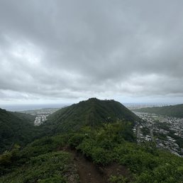
Perfect hike! This hike was a perfect start to the morning. The entrance was a bit tricky to find at first but once we found it the reward was amazing. The hike starts on the top of the mountain and you walk along the ridge for most of it. It has its steep rocky moments but, this is a pretty beginner hike overall. I recommend not going on a super windy or rainy day because it can become dangerous. The best time to go I believe is bright in early morning or just before sunset. This is my favorite hike yet!

This is by far my favorite short hike to do after work or if I just want some great mountain views. The entrance of the hike is located in a neighborhood, its a drive up a very steep hill. Please be respectful of the neighborhood and the hike itself as well. It's a very secluded hike, as I rarely see many hikers while I am on the hike. It is also connected to another trail that is a longer hike to get to the other ridge. This hike takes me about 20 mins to get to the bench. This bench was made as a memorial for a fellow hiker, there is a plaque on the side of the bench which you can read and pay your respects. The hike is fairly easy as you are descending first then ascending up to the bench. Although it looks easy, there are loose dirt and rocks so please be careful. You are basically hiking a ridge with lots of room, but always be safe anyway. About 5 mins into the hike you are already greeted with a 360 view of the mountains, ocean, and city. When I don't feel like hiking the trail, I would sometimes come to this view point to sit and relax and even have some snacks while enjoying the view. Some Few Tips: -Hike on a non windy/non rainy day for this particular hike. On a windy day since it has a valley on both sides, the wind can become dangerously harsh. Rain can make the trail slippery and dangerous. -Wear sun guards as you are hiking a ridge and exposed to the sun. -Be careful, although the trail seems easy, anything can happen. -Stay on the trail, some of the rocks are bound to break off from the edge.

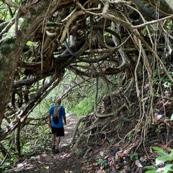
After deciding against Stairway to Heaven due to lack of preparation we turned to this hike - thank you AllTrails! It was a bit of a drive from Kaneohe to the trailhead but it was simple and easy to find. It starts in a residential area through a chain link fence off the road. Street parking available steps from the entrance. This hike is an in and out with multiple peaks. The peak at the end is higher than Ka'au Krater's ridge and you can look down into the crater from multiple vantage points along the hike. WEAR PANTS . The last half of the trail is almost completely overgrown and will scratch you up. Water and food are a must. This is not a casual hike. One of our group turned back about a third of the way through it. But the top is absolutely worth it. Such a fulfilling and satisfying hike. Nothing too dangerous or risky, simply long and steep and scratchy.

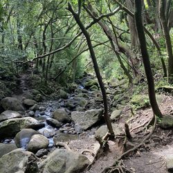
Definitely a long and narrow trail once your get past the initial stretch and bench. And pretty difficult at times. Took almost 6 hours round trip to complete (including about 1 hour to enjoy the wonderful Windward Side views at the end and summit). Parts of the trail can be really muddy and there are lots of stag horn ferns that will literally and figuratively scratch you up. Even when wearing long pants, expect lots of snags when brushing against all those plants, so choose apparel that you won't mind getting damaged.

Wow, this hike is beautiful! It's a lot of uphill and climbing. There are narrow paths with steep cliffs on either side so I'm not sure if I would recommend bringing children to this one. This is perfect if you're looking for gorgeous views and a bit of a workout! We had trouble finding the entrance, it's a bit overgrown and right next to a driveway with a small sign.

Great trail to hike in slippers! Pretty easy and the parking was easy too. Started the hike late and brought flashlights. About halfway up the trail is a clearing with great views all around from east to west. Stopped there as it was already dark and admired the night time skyline of town and the stars above. Will do again, maybe do a sunrise hike.

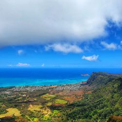
I'm surprised to find I'm the first Yelper here. This is a beautiful 6.24 mile hike that leads you over views of Ka'au Crater and the Honolulu skyline. The sign at the entrance posts mileage of 3.7 mile to the summit but using GPS I found it to be less. Here are three things that I learned about this hike: 1. Choose a dry day, some parts can be muddy. 2. Wear trail pants, ferns can scratch the hairs off your legs. 3. You may need a hat because 80% is uncovered. The views at the summit make it all worth it. As with many hikes like this the view can be dependent on weather. We could see all the way to Chinaman's hat and to Kokohead. GPS shows summit at 2386ft. you tower over Olomana. Google Maps shows address 4945 Maunalani Cir. however it is next door to 4969 driveway. See some of my pics. I'll save the best views for you.

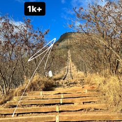
Most people call this the Lanipo hike. Park at the top of Maunalani Circle near the fence. There's a sign at the start of the hike and you walk between the fences next to the home there to start it off. This is one of the harder hikes on this side of the island. It's about 7 miles round trip and should take 4-5 hours to do at a decent pace. At the time of my review the 2nd half of the trail is very overgrown. The ferns will eat you alive! I suggest you wear long pants, long sleeves, and bring gloves. HTMC is planning to clear out the trail on 7/21 according to their calender so you might want to go after that happens if possible. You get a great view of Ka'au Crater on the left while you go up (see attached picture). If you look closely you can even see the waterfalls on your way up. You also get a nice view of Wiliwilinui on the right side while going up.

I didn't make it to the end so I can't speak for the parts that are muddy but at least to the bench and a little beyond are awesome. It's a ridge hike with ups and down and lots of rocks to climb over. Helllllo quads, hamstrings, and glutes! The views are beautiful, especially for sunset. Lots and lots of gnats flying around our faces was our biggest gripe. Bring water, not much shade. Perhaps wear pants, lots in the beginning and end are overgrown. Looking forward to hiking all the way to the summit soon!

3 years ago
Staying in Waikiki and don't want to travel too far for a trail? Go here. It's about a 15-minute drive from your hotel and most of it is steep uphill into a rich neighborhood, so make sure your car can handle the incline. The only drawback, I'd say, is that because it's so close to the city and next to bunch of homes, you'll feel like you're in someone's backyard; you can literally hear dogs barking and garbage trucks coming and going. So if you're looking for peace and serenity, maybe this isn't for you. Google will take you to a gated, private property area. Parking is on the street. The entrance is a narrow opening at the end of the fence line. Easy to spot. So I've seen some reviews that say the trail is a couple miles roundtrip, but it's much, much further than that. Most people will hike to the first bench, and then turn around. You can go further up and it's pretty hard work. Lots of rocks to traverse and it's steep in some parts, so be prepared to climb a little. Also, because it's on a ridge, it's narrow in a few areas so don't look down if you're afraid of heights. Having said that, wear hiking shoes with good traction. Otherwise, you'll have a hard time for sure. Didn't have time to do the whole trail, but I went in far enough to feel the bit of elevation change. Went on a hot, dry day, so the trail was in good shape. I can only imagine how difficult it would be if it rained. Anyway, even you don't go deep into the trail, the first bench will still provide you with a fantastic view of the ocean and city. I'll definitely come back to do the whole thing. read more


Great hike, like the other ridge hikes to the east but longer. Took right around 4 hours of moving time, longer with a couple of stops for pictures and to enjoy the views and breeze at the top. Some area with ropes that aren't really necessary when it's dry, would probably be needed in the wet. Some very overgrown areas where you have to watch your footing. read more


3 years ago
I love this hike. Diamond head needed reservations so we luckily were able to find this spot 10 minutes away. Views of the valley were incredible and the best part was we didn't run into anyone here! read more

2 years ago
Perfect hike! This hike was a perfect start to the morning. The entrance was a bit tricky to find at first but once we found it the reward was amazing. The hike starts on the top of the mountain and you walk along the ridge for most of it. It has its steep rocky moments but, this is a pretty beginner hike overall. I recommend not going on a super windy or rainy day because it can become dangerous. The best time to go I believe is bright in early morning or just before sunset. This is my favorite hike yet! read more


6 years ago
This is by far my favorite short hike to do after work or if I just want some great mountain views. The entrance of the hike is located in a neighborhood, its a drive up a very steep hill. Please be respectful of the neighborhood and the hike itself as well. It's a very secluded hike, as I rarely see many hikers while I am on the hike. It is also connected to another trail that is a longer hike to get to the other ridge. This hike takes me about 20 mins to get to the bench. This bench was made as a memorial for a fellow hiker, there is a plaque on the side of the bench which you can read and pay your respects. The hike is fairly easy as you are descending first then ascending up to the bench. Although it looks easy, there are loose dirt and rocks so please be careful. You are basically hiking a ridge with lots of room, but always be safe anyway. About 5 mins into the hike you are already greeted with a 360 view of the mountains, ocean, and city. When I don't feel like hiking the trail, I would sometimes come to this view point to sit and relax and even have some snacks while enjoying the view. Some Few Tips: -Hike on a non windy/non rainy day for this particular hike. On a windy day since it has a valley on both sides, the wind can become dangerously harsh. Rain can make the trail slippery and dangerous. -Wear sun guards as you are hiking a ridge and exposed to the sun. -Be careful, although the trail seems easy, anything can happen. -Stay on the trail, some of the rocks are bound to break off from the edge. read more


After deciding against Stairway to Heaven due to lack of preparation we turned to this hike - thank you AllTrails! It was a bit of a drive from Kaneohe to the trailhead but it was simple and easy to find. It starts in a residential area through a chain link fence off the road. Street parking available steps from the entrance. This hike is an in and out with multiple peaks. The peak at the end is higher than Ka'au Krater's ridge and you can look down into the crater from multiple vantage points along the hike. WEAR PANTS . The last half of the trail is almost completely overgrown and will scratch you up. Water and food are a must. This is not a casual hike. One of our group turned back about a third of the way through it. But the top is absolutely worth it. Such a fulfilling and satisfying hike. Nothing too dangerous or risky, simply long and steep and scratchy. read more


2 years ago
Definitely a long and narrow trail once your get past the initial stretch and bench. And pretty difficult at times. Took almost 6 hours round trip to complete (including about 1 hour to enjoy the wonderful Windward Side views at the end and summit). Parts of the trail can be really muddy and there are lots of stag horn ferns that will literally and figuratively scratch you up. Even when wearing long pants, expect lots of snags when brushing against all those plants, so choose apparel that you won't mind getting damaged. read more


5 years ago
Wow, this hike is beautiful! It's a lot of uphill and climbing. There are narrow paths with steep cliffs on either side so I'm not sure if I would recommend bringing children to this one. This is perfect if you're looking for gorgeous views and a bit of a workout! We had trouble finding the entrance, it's a bit overgrown and right next to a driveway with a small sign. read more


5 years ago
Great trail to hike in slippers! Pretty easy and the parking was easy too. Started the hike late and brought flashlights. About halfway up the trail is a clearing with great views all around from east to west. Stopped there as it was already dark and admired the night time skyline of town and the stars above. Will do again, maybe do a sunrise hike. read more

I'm surprised to find I'm the first Yelper here. This is a beautiful 6.24 mile hike that leads you over views of Ka'au Crater and the Honolulu skyline. The sign at the entrance posts mileage of 3.7 mile to the summit but using GPS I found it to be less. Here are three things that I learned about this hike: 1. Choose a dry day, some parts can be muddy. 2. Wear trail pants, ferns can scratch the hairs off your legs. 3. You may need a hat because 80% is uncovered. The views at the summit make it all worth it. As with many hikes like this the view can be dependent on weather. We could see all the way to Chinaman's hat and to Kokohead. GPS shows summit at 2386ft. you tower over Olomana. Google Maps shows address 4945 Maunalani Cir. however it is next door to 4969 driveway. See some of my pics. I'll save the best views for you. read more


13 years ago
Most people call this the Lanipo hike. Park at the top of Maunalani Circle near the fence. There's a sign at the start of the hike and you walk between the fences next to the home there to start it off. This is one of the harder hikes on this side of the island. It's about 7 miles round trip and should take 4-5 hours to do at a decent pace. At the time of my review the 2nd half of the trail is very overgrown. The ferns will eat you alive! I suggest you wear long pants, long sleeves, and bring gloves. HTMC is planning to clear out the trail on 7/21 according to their calender so you might want to go after that happens if possible. You get a great view of Ka'au Crater on the left while you go up (see attached picture). If you look closely you can even see the waterfalls on your way up. You also get a nice view of Wiliwilinui on the right side while going up. read more


I didn't make it to the end so I can't speak for the parts that are muddy but at least to the bench and a little beyond are awesome. It's a ridge hike with ups and down and lots of rocks to climb over. Helllllo quads, hamstrings, and glutes! The views are beautiful, especially for sunset. Lots and lots of gnats flying around our faces was our biggest gripe. Bring water, not much shade. Perhaps wear pants, lots in the beginning and end are overgrown. Looking forward to hiking all the way to the summit soon! read more


6 years ago
14 years ago
11 years ago
takes about 5 hours, but not dangerous. awesome views almost the whole way. some loose dirt, so wear shoes and be careful. almost entirely uncovered, so wear a hat and sunscreen. do it read more


11 years ago
More info about Mau'umae Trail
4945 Maunalani Cir
Honolulu, HI 96816
Directions
Hours
Outdoor Amenities
Ask the Community - Mau'umae Trail
Review Highlights - Mau'umae Trail
You might also consider


Mau'umae Trail - hiking - Updated July 2026
Best of Honolulu
People found Mau'umae Trail by searching for…
Hiking Trails in Honolulu, Hawaii
Scenic Night View in Honolulu, Hawaii
Rock Climbing in Honolulu, Hawaii
Waterfall Hike in Honolulu, Hawaii
Night Hike in Honolulu, Hawaii
Waterfalls in Honolulu, Hawaii
Scenic Overlook in Honolulu, Hawaii
Off Road Trails in Honolulu, Hawaii
Easy Hikes in Honolulu, Hawaii
Walking Groups in Honolulu, Hawaii
Hiking Club in Honolulu, Hawaii
Watch Sunset in Honolulu, Hawaii
Sunrise View in Honolulu, Hawaii
Walking Trails in Honolulu, Hawaii
Bamboo Forest in Honolulu, Hawaii
Stroller Friendly Hikes in Honolulu, Hawaii
Dog Friendly Hiking Trails in Honolulu, Hawaii
Stair Climbing in Honolulu, Hawaii
Sunrise Hike in Honolulu, Hawaii
Running Trails in Honolulu, Hawaii
Trending Searches in Honolulu, HI
4th Of July Fireworks near Mau'umae Trail
Boat Rental near Mau'umae Trail
Cliff Jumping near Mau'umae Trail
Jet Ski Rental near Mau'umae Trail
Kayak Rental near Mau'umae Trail
Lakes & Ponds near Mau'umae Trail
Off Road Trails near Mau'umae Trail
Outdoor Activities near Mau'umae Trail
Parks For Picnics near Mau'umae Trail
Places To Walk Around near Mau'umae Trail
Public Pools near Mau'umae Trail
Public Shower near Mau'umae Trail
River Swimming near Mau'umae Trail
Rock Quarry near Mau'umae Trail
Scenic Night View near Mau'umae Trail
Scenic Overlook near Mau'umae Trail
Secluded Spots near Mau'umae Trail
Soccer Store near Mau'umae Trail
Splash Pad near Mau'umae Trail
Strawberry Picking near Mau'umae Trail
Sunrise View near Mau'umae Trail
Swimming Holes near Mau'umae Trail
Swimming Lakes near Mau'umae Trail
U Pick Farms near Mau'umae Trail
Watch Sunset near Mau'umae Trail
Browse Articles
Browse Nearby
BEST of Honolulu, Hawaii Coffee near Mau'umae Trail
BEST of Honolulu, Hawaii Things to Do near Mau'umae Trail
BEST of Honolulu, Hawaii Restaurants near Mau'umae Trail
BEST of Honolulu, Hawaii Parks near Mau'umae Trail
BEST of Honolulu, Hawaii Breakfast near Mau'umae Trail
BEST of Honolulu, Hawaii Walking Trails near Mau'umae Trail
BEST of Honolulu, Hawaii Campgrounds near Mau'umae Trail
Browse Brands
Related Searches in Honolulu, HI
Affordable Kayak Rental Services in Honolulu, Hawaii
Best Fishing Locations and Guides in Honolulu, Hawaii
Best Nature Trails for Hiking in Honolulu, Hawaii
Best Places for Horseback Riding in Honolulu, Hawaii
Best Waterfalls and Swimming Holes in Honolulu, Hawaii
Check Out Off Road Trails in Honolulu, Hawaii
Discover Dog Friendly Trails to Explore in Honolulu, Hawaii
Discover Kid Friendly Hiking Trails in Honolulu, Hawaii
Discover Scenic Hiking Trails in Honolulu, Hawaii
Discover Scenic Waterfall Spots in Honolulu, Hawaii
Discover Walking Parks in Honolulu, Hawaii Near You
Discover a Hiking Trail in Honolulu, Hawaii
Discover the Best Night Hike Trails in Honolulu, Hawaii
Dog-Friendly Hikes With Dogs in Honolulu, Hawaii
Enjoy Camping Adventures Around Honolulu, Hawaii
Enjoy Kayaking Adventures in Honolulu, Hawaii
Enjoy Tent Camping Spots Around Honolulu, Hawaii
Enjoy a Beautiful Waterfall Hike in Honolulu, Hawaii
Enjoy a Peaceful Nature Walk in Honolulu, Hawaii
Enjoy the Best Picnic Spots and Ideas in Honolulu, Hawaii
Enjoy the Best Walking Path in Honolulu, Hawaii
Enjoy the Best Walking Trails in Honolulu, Hawaii
Exciting Cliff Jumping Spots in Honolulu, Hawaii
Explore Beautiful Parks and Green Spaces in Honolulu, Hawaii
Explore Easy Hikes Perfect for All in Honolulu, Hawaii
Explore Fun Activities to Do in Honolulu, Hawaii
Explore Popular Campgrounds Near Honolulu, Hawaii
Explore the Best Beach Spots in Honolulu, Hawaii
Explore the Best Swimming Holes Around Honolulu, Hawaii
Explore the Best Trail Options in Honolulu, Hawaii
Family Friendly Hiking With Kids in Honolulu, Hawaii
Find Popular Ziplining Spots Around Honolulu, Hawaii
Find the Best Parks for Picnics in Honolulu, Hawaii
Find the Best Scenic View Locations in Honolulu, Hawaii
Great Places to Walk in Honolulu, Hawaii
Hike the Popular Waterfall Trail in Honolulu, Hawaii
Hiking Trails With Waterfalls in Honolulu, Hawaii
Off Leash Dog Hiking Trails in Honolulu, Hawaii
Plan a Scenic Drive Route Near Honolulu, Hawaii
Popular Outdoor Activities to Try in Honolulu, Hawaii
Popular Picnic Spots to Visit in Honolulu, Hawaii
Safe River Swimming Areas in Honolulu, Hawaii
Safe and Fun Parks for Kids in Honolulu, Hawaii
Top Climbing Spots and Gyms in Honolulu, Hawaii
Top Paddleboarding Activities in Honolulu, Hawaii
Top Places for Snorkeling in Honolulu, Hawaii
Top Running Trails to Explore in Honolulu, Hawaii
Top Swimming Spots and Pools in Honolulu, Hawaii
People who viewed Mau'umae Trail also viewed
Waʻahila Ridge State Recreation Area
116 reviews
Makiki Valley Trail
120 reviews
Kuliouou Ridge Trail
410 reviews
Kulepeamoa Ridge Hike
9 reviews
Niu Valley
Mo'ole Valley
5 reviews
Ka'au Crater
197 reviews
Wiliwilinui Ridge Trail
159 reviews
Hanauma Bay Trail
177 reviews
Hawaii Kai
Moleka Trail
3 reviews
Kolowalu Trail
7 reviews
Manoa