Hamama Falls Photos


You might also consider
More like Hamama Falls
Recommended Reviews - Hamama Falls
Start your review...

Reviews With Photos

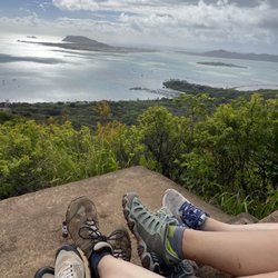
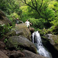
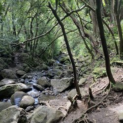
Hamama falls and Waihe'e falls are two different waterfalls but on the same path. It was confusing others including myself reading reviews on Waihe'e falls page so I decided to start here. After parking in a residential area and quietly walking up the street through the neighbored there is a No trespassing sign by Board of Water Supply. Walking around the gate, shorter to cut around the right side than the left, and then you start the trail. A little gravel road in the beginning and a nice swimming hole within 10 mins of walking in. We trek'd our way to the Hamama Falls. It was such a beautiful day with no clouds in sight and no rain the days before. However the rocks walking up some inclined hills were a bit slippery. It's always harder walking down the trail then up. About 1hour later we reached Hamama Falls! So stunningly beautiful. Lots of young keiki are able to do this hike as well. I did this pregnant so it was manageable. We took lots of pictures with our go pro's, climbed the waterfall to sit on, and made our way back down. Overall this hike probably took us 1hour and 30minutes with my little mini prego breaks haha.

My local friends took me on this short but sweet hike. Yes, it is on private land, owned by the Water Board, but it seems that the public trespassing is tolerated. There's a large gate/fence at the entrance, but everyone goes around it on either side. On this day, there was even an official water board truck that passed us as we made our way to the gate. We encountered a steady stream of folks coming back down, as we started our hike. It had rained a little bit the previous day, so it was muddy at parts. About par for the course on any Hawaiian hike it seems. The falls itself is pretty thin, but you can cool off by going under the falls. I can see why this is so popular among the locals, especially on hot days. Easy access and short hike with a nice payoff.

This place was just magical! The hike was fairly easy to get to. Paved road for the most part. A little muddy but then again you're going through a RAINFOREST lol. The hike probably took a total of an hour to get to since my husband and I were filming. But once we got to the falls, wow and I mean WOW it was so beautiful. The water was freezing! But well worth it!

I don't hike a lot but friends wanted to go so we did the trek. Another friend who hikes a LOT told me it's one of the most beautiful hikes he's been on. While I don't have a large amount of destination spots to compare, I do have my share of hiking experiences. It really was beautiful. So many picturesque spots. Got some great photos on the way up to the falls. Be sure to have good footwear as it can get pretty slippery. While most of the path is graveled, there are numerous areas where you could easily fall. If you're a mosquito magnet, put your bug spray on before you start the hike and take it with you. I still came out with a bunch of bites, mainly cause my sweat washed some of the protection off. Had a great time. Highly recommend. read more


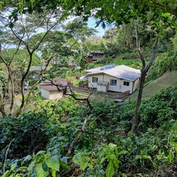
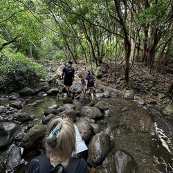
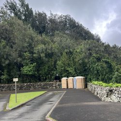
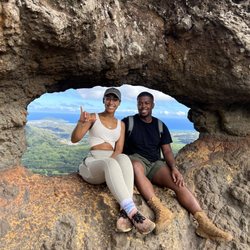
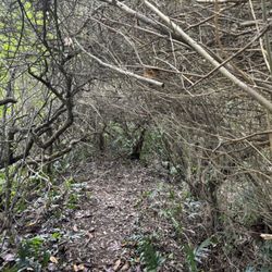
I wrote a much longer review for Waihe falls which is actually the same hike. Most people thing that Waihe falls is actually Hamama falls but it is not. All those photos of that tall triangular shaped waterfall is Hamama falls. Its the one where there is some kinda water dept piping right before it. Waihe falls is downstream from Hamama falls. You can hear it and its half the size but the trail is overgrown in inaccessible. Anyway Hamama is great for all the photo ops. There's not much of a pool at the bottom just some rocks, debris and then it goes into a stream. Which is great cause you can get real close up to it. The trail is most like an old service road suitable for an ATV. Its about 3 miles out and back. It has some steep bits where the road goes into an S curve and is slightly washed out and slick so be careful. You pass by a couple of cool board of water supply structure and some power structures which are rigged with alarms. You'll be ok as long as you stay on the road. There's a dam with a swimming hole too that kinda fun. Reviewing this trail completely backwards, the gate at the front is no tresspassing. people just walk around to the left. I had people servicing whatever buildings there and no one bothered me, just stay away from any utility buildings. Also be respectful to the people that live there. Don't block their mailboxes, driveways, or garbage can. Don't try to squeeze in. just park further down. Also last time I was there, I saw someone's rear window smashed in. Nothing was stolen, but yeah I did notice their car was partially obstructing the adjacent driveway. Yeah no witnesses. Just saying. read more


Hamama falls and Waihe'e falls are two different waterfalls but on the same path. It was confusing others including myself reading reviews on Waihe'e falls page so I decided to start here. After parking in a residential area and quietly walking up the street through the neighbored there is a No trespassing sign by Board of Water Supply. Walking around the gate, shorter to cut around the right side than the left, and then you start the trail. A little gravel road in the beginning and a nice swimming hole within 10 mins of walking in. We trek'd our way to the Hamama Falls. It was such a beautiful day with no clouds in sight and no rain the days before. However the rocks walking up some inclined hills were a bit slippery. It's always harder walking down the trail then up. About 1hour later we reached Hamama Falls! So stunningly beautiful. Lots of young keiki are able to do this hike as well. I did this pregnant so it was manageable. We took lots of pictures with our go pro's, climbed the waterfall to sit on, and made our way back down. Overall this hike probably took us 1hour and 30minutes with my little mini prego breaks haha. read more


My local friends took me on this short but sweet hike. Yes, it is on private land, owned by the Water Board, but it seems that the public trespassing is tolerated. There's a large gate/fence at the entrance, but everyone goes around it on either side. On this day, there was even an official water board truck that passed us as we made our way to the gate. We encountered a steady stream of folks coming back down, as we started our hike. It had rained a little bit the previous day, so it was muddy at parts. About par for the course on any Hawaiian hike it seems. The falls itself is pretty thin, but you can cool off by going under the falls. I can see why this is so popular among the locals, especially on hot days. Easy access and short hike with a nice payoff. read more

This place was just magical! The hike was fairly easy to get to. Paved road for the most part. A little muddy but then again you're going through a RAINFOREST lol. The hike probably took a total of an hour to get to since my husband and I were filming. But once we got to the falls, wow and I mean WOW it was so beautiful. The water was freezing! But well worth it! read more

6 years ago
5 years ago
7 years ago
7 years ago
7 years ago
it looks sketchy going in at first because you have to go behind the gate but once you are there it's a nice even path. once you keep going the path gets more rocky and steeper. The walk is about 2 mile but once you reach the waterfall it is amazing. definitely worth the hike. read more

7 years ago
More info about Hamama Falls
47-280 Waihee Rd
Kaneohe, HI 96744
Directions
Hours
Indoor Amenities
Outdoor Amenities
Ask the Community - Hamama Falls
Is this open now -April 2022?
Is it closed?
Yes. CLOSED. Honolulu Police are there to enforce trespassing laws and educate the hikers. Neighbors in the area call the police for parking violations people with backpacks - who they think are going hiking… Read more
Review Highlights - Hamama Falls
You might also consider


Why does Yelp recommend reviews?
1 review that is not currently recommended
The reviews below are not factored into the business's overall star rating.
7 years ago
Hamama Falls - hiking - Updated July 2026
Best of Kaneohe
People found Hamama Falls by searching for…
Things to Do in Kaneohe, Hawaii
Hiking Trails in Kaneohe, Hawaii
Waterfall Hike in Kaneohe, Hawaii
Swimming Holes in Kaneohe, Hawaii
Abandoned Places in Kaneohe, Hawaii
River Swimming in Kaneohe, Hawaii
Dog Friendly Parks in Kaneohe, Hawaii
Photo Spots in Kaneohe, Hawaii
Off Road Trails in Kaneohe, Hawaii
Walking Trails in Kaneohe, Hawaii
Dog Friendly Hiking Trails in Kaneohe, Hawaii
Walking Groups in Kaneohe, Hawaii
Dog Friendly Things to Do in Kaneohe, Hawaii
Hiking Club in Kaneohe, Hawaii
Running Trails in Kaneohe, Hawaii
Trending Searches in Kaneohe, HI
4th Of July Fireworks near Hamama Falls
Cliff Jumping near Hamama Falls
Jet Ski Rental near Hamama Falls
Kayak Rental near Hamama Falls
Lakes & Ponds near Hamama Falls
Off Road Trails near Hamama Falls
Outdoor Activities near Hamama Falls
Parks For Picnics near Hamama Falls
Places To Walk Around near Hamama Falls
Public Pools near Hamama Falls
Public Shower near Hamama Falls
River Swimming near Hamama Falls
Scenic Night View near Hamama Falls
Scenic Overlook near Hamama Falls
Secluded Spots near Hamama Falls
Soccer Store near Hamama Falls
Strawberry Picking near Hamama Falls
Sunrise View near Hamama Falls
Swimming Holes near Hamama Falls
Swimming Lakes near Hamama Falls
U Pick Farms near Hamama Falls
Browse Articles
Browse Nearby
BEST of Kaneohe, Hawaii Coffee near Hamama Falls
BEST of Kaneohe, Hawaii Things to Do near Hamama Falls
BEST of Kaneohe, Hawaii Restaurants near Hamama Falls
BEST of Kaneohe, Hawaii Breakfast near Hamama Falls
BEST of Kaneohe, Hawaii Walking Trails near Hamama Falls
BEST of Kaneohe, Hawaii Parks near Hamama Falls
Browse Brands
Related Searches in Kaneohe, HI
Affordable Kayak Rental Services in Kaneohe, Hawaii
Best Fishing Locations and Guides in Kaneohe, Hawaii
Best Nature Trails for Hiking in Kaneohe, Hawaii
Best Places for Horseback Riding in Kaneohe, Hawaii
Best Waterfalls and Swimming Holes in Kaneohe, Hawaii
Check Out Off Road Trails in Kaneohe, Hawaii
Discover Dog Friendly Trails to Explore in Kaneohe, Hawaii
Discover Scenic Hiking Trails in Kaneohe, Hawaii
Discover Scenic Waterfall Spots in Kaneohe, Hawaii
Discover Walking Parks in Kaneohe, Hawaii Near You
Discover a Hiking Trail in Kaneohe, Hawaii
Discover the Best Night Hike Trails in Kaneohe, Hawaii
Enjoy Camping Adventures Around Kaneohe, Hawaii
Enjoy Kayaking Adventures in Kaneohe, Hawaii
Enjoy Tent Camping Spots Around Kaneohe, Hawaii
Enjoy Water Activities and Fun in Kaneohe, Hawaii
Enjoy a Beautiful Waterfall Hike in Kaneohe, Hawaii
Enjoy a Peaceful Nature Walk in Kaneohe, Hawaii
Enjoy the Best Picnic Spots and Ideas in Kaneohe, Hawaii
Enjoy the Best Walking Path in Kaneohe, Hawaii
Enjoy the Best Walking Trails in Kaneohe, Hawaii
Exciting Cliff Jumping Spots in Kaneohe, Hawaii
Explore Beautiful Parks and Green Spaces in Kaneohe, Hawaii
Explore Easy Hikes Perfect for All in Kaneohe, Hawaii
Explore Fun Activities to Do in Kaneohe, Hawaii
Explore Popular Campgrounds Near Kaneohe, Hawaii
Explore the Best Beach Spots in Kaneohe, Hawaii
Explore the Best Swimming Holes Around Kaneohe, Hawaii
Explore the Best Trail Options in Kaneohe, Hawaii
Family Friendly Hiking With Kids in Kaneohe, Hawaii
Find Beautiful Views in Kaneohe, Hawaii
Find Popular Ziplining Spots Around Kaneohe, Hawaii
Find the Best Parks for Picnics in Kaneohe, Hawaii
Find the Best Scenic View Locations in Kaneohe, Hawaii
Great Places to Walk in Kaneohe, Hawaii
Hike the Popular Waterfall Trail in Kaneohe, Hawaii
Hiking Trails With Waterfalls in Kaneohe, Hawaii
Off Leash Dog Hiking Trails in Kaneohe, Hawaii
Plan a Scenic Drive Route Near Kaneohe, Hawaii
Popular Outdoor Activities to Try in Kaneohe, Hawaii
Popular Picnic Spots to Visit in Kaneohe, Hawaii
Safe River Swimming Areas in Kaneohe, Hawaii
Safe and Fun Parks for Kids in Kaneohe, Hawaii
Top Climbing Spots and Gyms in Kaneohe, Hawaii
Top Paddleboarding Activities in Kaneohe, Hawaii
Top Places for Snorkeling in Kaneohe, Hawaii
Top Running Trails to Explore in Kaneohe, Hawaii
Top Swimming Spots and Pools in Kaneohe, Hawaii