Maunawili Trail Photos


 - Hiking Near Me - Kaneohe, Hawaii")


You might also consider
More like Maunawili Trail
Recommended Reviews - Maunawili Trail
Start your review...

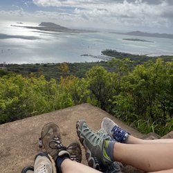
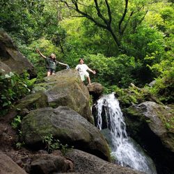
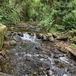
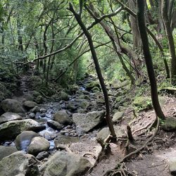
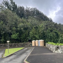
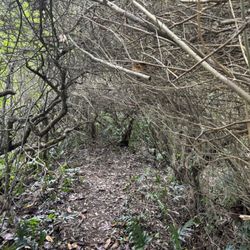
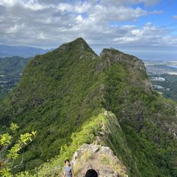
PARK ON THE HIGHWAY AT THE SCENIC POINT PULLOUT (leave a completely empty car, as there have been break-ins here before). Really cool rainforest trail. Mostly shaded. **Wear trail shoes** for the multiple slippery patches of mud you'll surely encounter (and keep a clean pair of sandals in the trunk for the drive home). We did this hike in early September '21 from the Pali Highway viewpoint entrance (because the more traditional neighborhood entrance was closed for a 2-year renovation project). I'd rate this hike 4.5 stars; of our six Oahu hikes this trip, this trail was my 2nd favorite (my favorite Oaho hike is the Kuliouou Ridge Trail).. WHAT I LIKE ABOUT THIS HIKE: It is a good workout (roughly 7miles and 2K feet elevation gain to the waterfall and back), there was varied terrain and views to keep me interested most of the way, and it was shaded throughout most of the trail, making it a great hike to do on a hot day (which it was the day that we went). Although the trail is clearly marked, there are a couple of places where it splits, and thus I'd recommend downloading the trailmap to your phone via Alltrails here, https://www.alltrails.com/trail/hawaii/oahu/maunawili-falls-from-pali-highway?u=i , so that you have a good feel of where to turn at forks. Some of the minor downsides (half star deduction): - There is minor overgrowth in a portion of the trail (not full blown bushwhacking, but definitely some flora rubbing up against ones legs for maybe a total of 1/4 to 1/2 mile in each direction). -- nothing pointy enough to cut you though (see pic of ferns) - There was a single exposed section of cliff that was about 5-10 feet in length, but there was an anchored rope attached to the wall that made me and my wife (who is scared of heights) feel comfortable crossing it (to tell you the truth, I was surprised my acrophobic wife was fine crossing that section, but surprisingly she was). (see pic with my hand on the yellow rope) - There were occasionally patches of mud that one had to navigate through, but it was all on flat portions and so with the proper trail shoes there wasn't really a danger of slipping; - My wife got freaked out by the single sign near the beginning of the trail that said or depicted the danger of picking up ordinance (i.e. it explodes); clearly any such ordinance must be off the trail, as we hiked the whole trail (which is clearly marked) and never saw any metal. - One needs to keep moving past the beautiful stream, rather than stopping there for a 10 minute lunch (unless one is Deeted up with bugyspray that is); we stopped there for lunch only to find out that mosquitoes hang out there and were chomping at our legs the whole time.....no mosquitoes anywhere else on the trail, and had we not stopped at the stream to eat lunch, I am confident we wouldn't have even gotten a single bite. - The parking area to the entrance, which is a viewpoint area on the highway, has suffered car breakins; we were weary leaving our car rental (for which I opted out of the insurance) there when we saw broken car window glass from previous break-ins, but we decided that given that our car was completely empty of anything to steal we'd take the chance. We were hiking for 4 hours, and fortunately when we returned our car was in tact just as we'd left it read more


More info about Maunawili Trail
6301 Pali Hwy
Kaneohe, HI 96744
Directions
Hours
Outdoor Amenities
You might also consider


Maunawili Trail - hiking - Updated May 2026
Best of Kaneohe
People found Maunawili Trail by searching for…
Trending Searches in Kaneohe, HI
Botanical Gardens near Maunawili Trail
Bounce House Rentals near Maunawili Trail
Campgrounds near Maunawili Trail
Cheap Plants near Maunawili Trail
Cherry Picking near Maunawili Trail
Cliff Jumping near Maunawili Trail
Dog Friendly Things To Do near Maunawili Trail
Flower Fields near Maunawili Trail
Flower Shop near Maunawili Trail
Garage Sales near Maunawili Trail
Garden Center near Maunawili Trail
Lakes & Ponds near Maunawili Trail
Nurseries & Gardening near Maunawili Trail
Outdoor Activities near Maunawili Trail
Outdoor Furniture Stores near Maunawili Trail
Party Equipment Rentals near Maunawili Trail
Photo Spots near Maunawili Trail
Picnic Areas near Maunawili Trail
Places To Take Pictures near Maunawili Trail
Rock Quarry near Maunawili Trail
Running Trails near Maunawili Trail
Rv Rental near Maunawili Trail
Spray Tanning near Maunawili Trail
Sunrise View near Maunawili Trail
Swimming Holes near Maunawili Trail
Table And Chair Rentals near Maunawili Trail
Browse Articles
Browse Nearby
BEST of Kaneohe, Hawaii Coffee near Maunawili Trail
BEST of Kaneohe, Hawaii Things to Do near Maunawili Trail
BEST of Kaneohe, Hawaii Restaurants near Maunawili Trail
BEST of Kaneohe, Hawaii Breakfast near Maunawili Trail
BEST of Kaneohe, Hawaii Walking Trails near Maunawili Trail
BEST of Kaneohe, Hawaii Parks near Maunawili Trail
BEST of Kaneohe, Hawaii Campgrounds near Maunawili Trail
Browse Brands
Related Searches in Kaneohe, HI
Affordable Kayak Rental Services in Kaneohe, Hawaii
Best Fishing Locations and Guides in Kaneohe, Hawaii
Best Nature Trails for Hiking in Kaneohe, Hawaii
Best Places for Horseback Riding in Kaneohe, Hawaii
Best Waterfalls and Swimming Holes in Kaneohe, Hawaii
Check Out Off Road Trails in Kaneohe, Hawaii
Discover Dog Friendly Trails to Explore in Kaneohe, Hawaii
Discover Scenic Hiking Trails in Kaneohe, Hawaii
Discover Scenic Waterfall Spots in Kaneohe, Hawaii
Discover Walking Parks in Kaneohe, Hawaii Near You
Discover a Hiking Trail in Kaneohe, Hawaii
Discover the Best Night Hike Trails in Kaneohe, Hawaii
Enjoy Camping Adventures Around Kaneohe, Hawaii
Enjoy Kayaking Adventures in Kaneohe, Hawaii
Enjoy Tent Camping Spots Around Kaneohe, Hawaii
Enjoy Water Activities and Fun in Kaneohe, Hawaii
Enjoy a Beautiful Waterfall Hike in Kaneohe, Hawaii
Enjoy a Peaceful Nature Walk in Kaneohe, Hawaii
Enjoy the Best Picnic Spots and Ideas in Kaneohe, Hawaii
Enjoy the Best Walking Path in Kaneohe, Hawaii
Enjoy the Best Walking Trails in Kaneohe, Hawaii
Exciting Cliff Jumping Spots in Kaneohe, Hawaii
Explore Beautiful Parks and Green Spaces in Kaneohe, Hawaii
Explore Easy Hikes Perfect for All in Kaneohe, Hawaii
Explore Fun Activities to Do in Kaneohe, Hawaii
Explore Popular Campgrounds Near Kaneohe, Hawaii
Explore the Best Beach Spots in Kaneohe, Hawaii
Explore the Best Swimming Holes Around Kaneohe, Hawaii
Explore the Best Trail Options in Kaneohe, Hawaii
Family Friendly Hiking With Kids in Kaneohe, Hawaii
Find Beautiful Views in Kaneohe, Hawaii
Find Popular Ziplining Spots Around Kaneohe, Hawaii
Find the Best Parks for Picnics in Kaneohe, Hawaii
Find the Best Scenic View Locations in Kaneohe, Hawaii
Great Places to Walk in Kaneohe, Hawaii
Hike the Popular Waterfall Trail in Kaneohe, Hawaii
Hiking Trails With Waterfalls in Kaneohe, Hawaii
Off Leash Dog Hiking Trails in Kaneohe, Hawaii
Plan a Scenic Drive Route Near Kaneohe, Hawaii
Popular Outdoor Activities to Try in Kaneohe, Hawaii
Popular Picnic Spots to Visit in Kaneohe, Hawaii
Safe River Swimming Areas in Kaneohe, Hawaii
Safe and Fun Parks for Kids in Kaneohe, Hawaii
Top Climbing Spots and Gyms in Kaneohe, Hawaii
Top Paddleboarding Activities in Kaneohe, Hawaii
Top Places for Snorkeling in Kaneohe, Hawaii
Top Running Trails to Explore in Kaneohe, Hawaii
Top Swimming Spots and Pools in Kaneohe, Hawaii