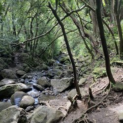
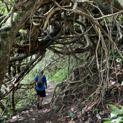
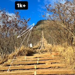
Lanipo Trail Photos


You might also consider
More like Lanipo Trail
Recommended Reviews - Lanipo Trail
Start your review...

Reviews With Photos


Lanipo is a great workout, easy to find, easy to follow - definitely one I would do again if I was hiking alone and needed some nice outdoor cardio. The fence at the trailhead is clearly marked and along almost the entire route you can see your destination (the summit, if that is where you'll turn around) taunting you at its distance. When you've reached the last third of the trek to the top, you'll start to get great views of the Ka'au Crater hike on your left. This was pretty sweet to see the hike I despise so much :P The inside of the crater was nice and green. http://www.yelp.com/biz_photos/lanipo-trail-honolulu-2?select=n2D6DZ3a-jnl5oHwIpALIQ#QozKAb-WonXIj0MkJDK2gA I've done longer hikes but for some reason the damn summit at the Koolau looked so far away every time I stopped to drink some water and catch my breath! I thought I'd never reach it! In and out, it is a total of 7 miles. http://www.yelp.com/biz_photos/lanipo-trail-honolulu-2?select=n2D6DZ3a-jnl5oHwIpALIQ#3vPtBdY-5QUp3AALu-zZ6Q At the top, we rested for a bit and turned right along the Koolau Summit trail and made our way to Wiliwilinui Summit (about another hour or so) to complete our hike. http://www.yelp.com/biz_photos/lanipo-trail-honolulu-2?select=n2D6DZ3a-jnl5oHwIpALIQ#4_xR6UN3smjaNUvUbcwMrw Remember to wear sunscreen and a hat or sweatband cause no matter what, you will sweat. There are quite a few really pleasant covered areas of the trail that feel almost like walking in an air-conditioned room for a moment but believe me, it doesn't last long! You will get all different terrains and climates along this hike, which is what made it most enjoyable for me. The trail was spectacularly maintained when I went (March 2013), thank you trail maintenance people of Oahu - your efforts are greatly appreciated!

With a five-hour time limit, I wanted to do a trail that was moderately long, and in the Honolulu area. Lanio (or Mau'umae Ridge) fit the bill. It is a definite up and down roller coaster of a hike. If you are not in good cardio shape, it will take it's toll on you very easily. With the lack of shade (thankfully there was cloud cover and awesome winds), the sun can drain you quickly as well. At least 2L of water is recommended. So yeah, ups and downs constantly as you slowly gain elevation. Beyond the halfway point, you start running into the annoying parts of the trail: uluhe and mud. Let me tell you: If you do not want your legs scratched up, wear long pants. Do not expect to get out of this trail with a clean pair of shoes. That being said, you can get a fantastic view of Ka'au Crater and a good view of the windward side on a clear day. Definitely good for cardio, just wear long pants and bring a good amount of water.

Fun, challenge ridge hike. Not for beginners. Pack a lot of water. Wear hood shoes. Hike starts in a dry environment and eases into the jungle for the majority of the trail. Fantastic views. Truly. As a ridge hike most of the trail has 500-2000 foot drops 1 foot to either side of the trail.

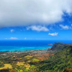
A few words of important advice before going on this trail. 1. Wear PANTS.... 2. Bring WATER and SNACKS 3. Go EARLY (at least by 10:30) I learned the hard way about number 1, so don't be an idiot like me and wear shorts. The green ferns are really pretty at first but they soon turn into mean overgrown branches and scratch at your legs and ankles merciless till you have to grow numb to the pain. The trail is also muddy so don't wear new sneakers. Besides the obvious negatives of the trail, it was a fun hike. I would rate this hike as an intermediate-advanced hike. There are a number of spots where its very narrow and you are climbing along a cliff which is covered by ferns so stay on the trail. On the way back my friend slipped and almost fell so be careful especially since you will be tired on the way back. Be ready for a lot of climbing up and down rocks, hills, and red dirt. It took us about 4 hours to get to the summit, we took our sweet time in the beginning taking pictures and such so I think if you were to cut some of the dillydallying it could take from 3-3.5 hrs. The way down took us 2.5 hrs. Its a 7.5 mile trail round trip so prepare to spend at least half your day on the trail. The views from the summit are breathtaking. You can see Kaneohe Bay, Olomana, Rabbit Island, and Honolulu. At times on the trail you may be frustrated by all the overgrown ferns which seem never-ending but just stick with it, the view from the top is so worth it. YELP 365: 110/365

Gorgeous ridge hike. You're rewarded with amazing views right away, which stay with you for the majority of the time. Even if you don't have time to complete the whole thing, it's worth going for the beginning because it's so beautiful from the get go. It's easy to follow and not dangerous at all (saw a lot of other dogs and kids on the hike). It's moderate difficulty, but it's long and gets hot up there, especially since a lot of it is not shaded. Go early and bring plenty of water. Your human may want some sunscreen.

After completing Kuliouou, Hawaii Loa, Wiliwilinui, Olomana, & Kaau Crater, I was looking for a longer, maybe more challenging hike. While Olomana & Kaau Crater are more technical, Lanipo was physically harder. Usually 1L of water is more than enough, but I ran out for the trip down. There was no trades this day, and cloud cover was pretty generous, but it was still hot as hell! I packed pants just in case and thank goodness! Got scratched pretty well and it was limiting my speed, but once I got pants on, I was able to pick up the pace. The uluhe ferns were at least waist high for the majority of the area it was growing, some shoulder height & I'm 5'6". The sign at the entrance says: "Ka Inawa'au Nui Summit 3.5 mi, Lanipo Summit, 3.7 mi." It took us 2hrs 8min to get to the top. Towards the right there's a short hill, followed by a taller hill which we assumed was the real Lanipo summit. The taller hill looked much farther than 0.2 miles. My friend & I decided to trek up there. Walking along the ridge wasn't too bad since it looked like it hadn't rained in awhile. Had it been raining or wet, we probably wouldn't have done it. The trail was about 2 feet wide in some places, wider in others. The path to the top was steep, but there were defined footholds all the way up. We went slowly since the path was overgrown and there's cliff on both sides, obviously. Parts of the trail were deceiving as there was foliage growing on the sides, but upon a closer look, there was no ground under it. Sure enough GPS tagged it as 0.2 miles and there was a little US Coast Survey marker identifying the hill as Lanipo. It took us 20 minutes one way. Usually it's faster and easier to get back down the mountain, but for this hike, it actually took longer. I was looking for a challenge and this hike delivered. I believe I was in a mild state of dehydration for the entire hike which wasn't entirely bad....at least I didn't have to pee.

Ummm Lanipo hike well its a great hike but be prepared to hike for about 5 hours depending on yor pace and how in shape you are. Its not hard it is just long... LONG!!! The views however are wonderful. You have views over looking Diamond head, Waikiki also Palolo Valley and on very clear days youll get other views. I do recommend you wear pants because the overgrown ferns scratch up and beat up your legs. And maybe a jacket because it gets cold as you go further up but also depending on the weather. There is also a beautiful view of Kaau Crater and the 3rd waterfall. Its amazing!

The trail entrance is tucked away a little, it almost seems like you are trespassing. This was the last hike I did on my last vacation. It is very pretty and I even came across a turtle. Then it began to rain, then I hit the section with the ferns. They are no joke, I thought I would be cool and tough it out, no you need pants. I couldn't finish the trail as it was so muddy and slippery and the ferns sucked. I will try it again!

My husband and I did this hike today and were pleasantly surprised by how awesome it is! To get to the trailhead, you have to drive to the top of Wilhelmina Rise then take a right once you reach the top at Maunalani Circle. Keep an eye out on the right side of the street because once you make it around the first bend you will see a fence with a sign marking the start of the trail. You can find parking on the right side of the street here. Once we went through the fence and started the trail, we soon found ourselves climbing downhill. The whole start of the trail was full of mellow inclines and declines. The trail is easy to stay on and not get lost. At about 3/4 of a mile in, there is a nice little bench with views of the two surrounding valleys as well as Honolulu. It seemed that around the 2 mile mark was where the trail started to become a bit overgrown with uluhe. I would definitely recommend wearing pants, I wore capris and now my calves are super scratched up! At about 2.5 miles was when we could start seeing Ka'au Crater and the waterfall, which was awesome! The trail is angled perfectly to see an amazing view of the crater and waterfall. There are a few ropes that we passed while going up but none of them were really necessary as the inclines were pretty mild. Once we got to the top there was a nice little grassy area that was nice to sit on and enjoy the gorgeous view!! From the top you can see Chinaman's hat, the Mokes, Koko Head, Diamondhead, Honolulu and the airport and much more! Round trip the hike is 7 miles with no significant inclines until the very end on the way back which isn't difficult to climb. I would rate this hike as intermediate. It is a step up from Kuliouou, Wiliwilinui and Hawaii Loa, but definitely not difficult or dangerous at all. Tips: - Wear long pants! - Bring sunscreen. There are a few shaded areas but most of the trail is exposed. - Wear a hat. - Bring water. - Bring a snack to eat at the top.

Wear pants, bring lots of water and a snack. Be smart. I finally did this hike on Saturday and I truly can't believe I waited so long. 7ish miles out and back of gorgeous views, interesting trails, and even a waterfall!! There are many incredible photo ops along the trail. Pants are crucial. The trail is overgrown with ferns that will destroy your legs on the way up and add insult to injury on the way back down. They're pretty hard on leggings so choose ones you don't care about or actual hiking pants. My leggings now have fringe up both sides. There are plenty of shade spots and incredible rest or turn around points. I'd say hike your own hike and feel good about wherever you get to. I assume the view from the top is fabulous, but was a solid wall of clouds when I was there. Still worth it. Gorgeous day in a gorgeous place! Hawaii life win! read more


Man, this is a tough hike! 5 1/2 hours roundtrip. I found the downhill harder -- especially on my legs and knees and yeah, I was damn tired when I finally finished! Definitely an advanced intermediate level hike that will test your endurance and reward you with spectacular views of the entire island. Get an early start and hope for cooler temps and some high clouds. While a good portion of this hike is shaded, the open areas, especially at the end, can be very hot and sunny. Bring plenty of water, lunch, and good hiking boots, gloves and micro spikes -- they'll all be needed near the top. Great views up and down and of course at the ridgeline. You'll see Ka'au crater and its waterfalls on the way up. read more


If you are staying in Waikiki, you can take the bus 14 from Kapahulu ave + Kalakaua avenue, which was a nice 15 minute walk from where I was staying (Moana Surfrider Westin). I chatted with the bus driver and was the only person on the bus for a good 45 minutes. The bus ride was quick and I soon arrived at my destination. The hike is a small narrow trail wedged between a half built house and gated fence. It should say.."no trespassing violators will be prosecuted" and underneath, "Lanipo trail." I was confused for a good 10 minutes, but if you see the shady sign with graffiti, that's where the hike is. Have no fear! Just go in. I went on this hike by myself and got my ass kicked so hard I was seeing stars. I started this hike around 11 am, which I completely regret because it was so damn hot. I was able to hike for 4 hours, but had to turn back because I was out of water and food. For those who are about to go on this hike, it is NOT easy. I thought I was physically capable and in shape to finish this entire hike, but I was exhausted. I fell a lot because I wasn't wearing the proper shoes; I was wearing Asics running shoes (that are now completely destroyed). But in all honestly, this hike pushed me to my limits and rewarded me with the most beautiful views. Getting back was brutal since the end has no shade and you are hoisting yourself up on the rocks you easily went down in the beginning of the hike. I took a 4 hour nap when I got back to the hotel hahaha. The trail is interesting itself though--it seems like you are passing different environments with different climates at each mountain you hike. The first mountain is dry, hot, and filled with rocks. The second mountain has a bunch of pine trees and ferns, which is cool and shady. The third mountain is completely covered with greenery and slippery mud. At that point, you are literally waist deep in ferns and plants while trying to hike through wet mud. At some mountains, you have to pull yourself up with rope or hoist yourself up using your hands. At others, you are skidding down the mountain with dry clay, so be careful. If I do this hike again, I would do these things: bring at least a liter of water with 3 energy bars, and oranges. Water is crucial. I was so dehydrated and weak at the end, I wanted to take a nap on the mountain and call the police to get me off the mountain with a helicopter, but I persevered because that rescue mission shit is expensive. Bring a hat, wear long pants because of the tall bushes, and consistently apply sunscreen. It's mostly a sun hike, so I would definitely recommend being prepared for the heat when you take on this hike. Good luck and have fun! read more


6 years ago
This trail really requires the title "Billy Goat", as I found myself hopping all around so that I didn't crash into the beautiful flora along the sides of the narrow, crooked path. read more


Lanipo is a great workout, easy to find, easy to follow - definitely one I would do again if I was hiking alone and needed some nice outdoor cardio. The fence at the trailhead is clearly marked and along almost the entire route you can see your destination (the summit, if that is where you'll turn around) taunting you at its distance. When you've reached the last third of the trek to the top, you'll start to get great views of the Ka'au Crater hike on your left. This was pretty sweet to see the hike I despise so much :P The inside of the crater was nice and green. http://www.yelp.com/biz_photos/lanipo-trail-honolulu-2?select=n2D6DZ3a-jnl5oHwIpALIQ#QozKAb-WonXIj0MkJDK2gA I've done longer hikes but for some reason the damn summit at the Koolau looked so far away every time I stopped to drink some water and catch my breath! I thought I'd never reach it! In and out, it is a total of 7 miles. http://www.yelp.com/biz_photos/lanipo-trail-honolulu-2?select=n2D6DZ3a-jnl5oHwIpALIQ#3vPtBdY-5QUp3AALu-zZ6Q At the top, we rested for a bit and turned right along the Koolau Summit trail and made our way to Wiliwilinui Summit (about another hour or so) to complete our hike. http://www.yelp.com/biz_photos/lanipo-trail-honolulu-2?select=n2D6DZ3a-jnl5oHwIpALIQ#4_xR6UN3smjaNUvUbcwMrw Remember to wear sunscreen and a hat or sweatband cause no matter what, you will sweat. There are quite a few really pleasant covered areas of the trail that feel almost like walking in an air-conditioned room for a moment but believe me, it doesn't last long! You will get all different terrains and climates along this hike, which is what made it most enjoyable for me. The trail was spectacularly maintained when I went (March 2013), thank you trail maintenance people of Oahu - your efforts are greatly appreciated! read more


With a five-hour time limit, I wanted to do a trail that was moderately long, and in the Honolulu area. Lanio (or Mau'umae Ridge) fit the bill. It is a definite up and down roller coaster of a hike. If you are not in good cardio shape, it will take it's toll on you very easily. With the lack of shade (thankfully there was cloud cover and awesome winds), the sun can drain you quickly as well. At least 2L of water is recommended. So yeah, ups and downs constantly as you slowly gain elevation. Beyond the halfway point, you start running into the annoying parts of the trail: uluhe and mud. Let me tell you: If you do not want your legs scratched up, wear long pants. Do not expect to get out of this trail with a clean pair of shoes. That being said, you can get a fantastic view of Ka'au Crater and a good view of the windward side on a clear day. Definitely good for cardio, just wear long pants and bring a good amount of water. read more


9 years ago
Fun, challenge ridge hike. Not for beginners. Pack a lot of water. Wear hood shoes. Hike starts in a dry environment and eases into the jungle for the majority of the trail. Fantastic views. Truly. As a ridge hike most of the trail has 500-2000 foot drops 1 foot to either side of the trail. read more


A few words of important advice before going on this trail. 1. Wear PANTS.... 2. Bring WATER and SNACKS 3. Go EARLY (at least by 10:30) I learned the hard way about number 1, so don't be an idiot like me and wear shorts. The green ferns are really pretty at first but they soon turn into mean overgrown branches and scratch at your legs and ankles merciless till you have to grow numb to the pain. The trail is also muddy so don't wear new sneakers. Besides the obvious negatives of the trail, it was a fun hike. I would rate this hike as an intermediate-advanced hike. There are a number of spots where its very narrow and you are climbing along a cliff which is covered by ferns so stay on the trail. On the way back my friend slipped and almost fell so be careful especially since you will be tired on the way back. Be ready for a lot of climbing up and down rocks, hills, and red dirt. It took us about 4 hours to get to the summit, we took our sweet time in the beginning taking pictures and such so I think if you were to cut some of the dillydallying it could take from 3-3.5 hrs. The way down took us 2.5 hrs. Its a 7.5 mile trail round trip so prepare to spend at least half your day on the trail. The views from the summit are breathtaking. You can see Kaneohe Bay, Olomana, Rabbit Island, and Honolulu. At times on the trail you may be frustrated by all the overgrown ferns which seem never-ending but just stick with it, the view from the top is so worth it. YELP 365: 110/365 read more


11 years ago
Gorgeous ridge hike. You're rewarded with amazing views right away, which stay with you for the majority of the time. Even if you don't have time to complete the whole thing, it's worth going for the beginning because it's so beautiful from the get go. It's easy to follow and not dangerous at all (saw a lot of other dogs and kids on the hike). It's moderate difficulty, but it's long and gets hot up there, especially since a lot of it is not shaded. Go early and bring plenty of water. Your human may want some sunscreen. read more


11 years ago
After completing Kuliouou, Hawaii Loa, Wiliwilinui, Olomana, & Kaau Crater, I was looking for a longer, maybe more challenging hike. While Olomana & Kaau Crater are more technical, Lanipo was physically harder. Usually 1L of water is more than enough, but I ran out for the trip down. There was no trades this day, and cloud cover was pretty generous, but it was still hot as hell! I packed pants just in case and thank goodness! Got scratched pretty well and it was limiting my speed, but once I got pants on, I was able to pick up the pace. The uluhe ferns were at least waist high for the majority of the area it was growing, some shoulder height & I'm 5'6". The sign at the entrance says: "Ka Inawa'au Nui Summit 3.5 mi, Lanipo Summit, 3.7 mi." It took us 2hrs 8min to get to the top. Towards the right there's a short hill, followed by a taller hill which we assumed was the real Lanipo summit. The taller hill looked much farther than 0.2 miles. My friend & I decided to trek up there. Walking along the ridge wasn't too bad since it looked like it hadn't rained in awhile. Had it been raining or wet, we probably wouldn't have done it. The trail was about 2 feet wide in some places, wider in others. The path to the top was steep, but there were defined footholds all the way up. We went slowly since the path was overgrown and there's cliff on both sides, obviously. Parts of the trail were deceiving as there was foliage growing on the sides, but upon a closer look, there was no ground under it. Sure enough GPS tagged it as 0.2 miles and there was a little US Coast Survey marker identifying the hill as Lanipo. It took us 20 minutes one way. Usually it's faster and easier to get back down the mountain, but for this hike, it actually took longer. I was looking for a challenge and this hike delivered. I believe I was in a mild state of dehydration for the entire hike which wasn't entirely bad....at least I didn't have to pee. read more

8 years ago
12 years ago
Ummm Lanipo hike well its a great hike but be prepared to hike for about 5 hours depending on yor pace and how in shape you are. Its not hard it is just long... LONG!!! The views however are wonderful. You have views over looking Diamond head, Waikiki also Palolo Valley and on very clear days youll get other views. I do recommend you wear pants because the overgrown ferns scratch up and beat up your legs. And maybe a jacket because it gets cold as you go further up but also depending on the weather. There is also a beautiful view of Kaau Crater and the 3rd waterfall. Its amazing! read more


9 years ago
The trail entrance is tucked away a little, it almost seems like you are trespassing. This was the last hike I did on my last vacation. It is very pretty and I even came across a turtle. Then it began to rain, then I hit the section with the ferns. They are no joke, I thought I would be cool and tough it out, no you need pants. I couldn't finish the trail as it was so muddy and slippery and the ferns sucked. I will try it again! read more


10 years ago
My husband and I did this hike today and were pleasantly surprised by how awesome it is! To get to the trailhead, you have to drive to the top of Wilhelmina Rise then take a right once you reach the top at Maunalani Circle. Keep an eye out on the right side of the street because once you make it around the first bend you will see a fence with a sign marking the start of the trail. You can find parking on the right side of the street here. Once we went through the fence and started the trail, we soon found ourselves climbing downhill. The whole start of the trail was full of mellow inclines and declines. The trail is easy to stay on and not get lost. At about 3/4 of a mile in, there is a nice little bench with views of the two surrounding valleys as well as Honolulu. It seemed that around the 2 mile mark was where the trail started to become a bit overgrown with uluhe. I would definitely recommend wearing pants, I wore capris and now my calves are super scratched up! At about 2.5 miles was when we could start seeing Ka'au Crater and the waterfall, which was awesome! The trail is angled perfectly to see an amazing view of the crater and waterfall. There are a few ropes that we passed while going up but none of them were really necessary as the inclines were pretty mild. Once we got to the top there was a nice little grassy area that was nice to sit on and enjoy the gorgeous view!! From the top you can see Chinaman's hat, the Mokes, Koko Head, Diamondhead, Honolulu and the airport and much more! Round trip the hike is 7 miles with no significant inclines until the very end on the way back which isn't difficult to climb. I would rate this hike as intermediate. It is a step up from Kuliouou, Wiliwilinui and Hawaii Loa, but definitely not difficult or dangerous at all. Tips: - Wear long pants! - Bring sunscreen. There are a few shaded areas but most of the trail is exposed. - Wear a hat. - Bring water. - Bring a snack to eat at the top. read more


10 years ago
9 years ago
11 years ago
9 years ago
10 years ago
This is my favorite hike so far on Oahu. It's definitely not for beginners. I'm not the most experienced hiker, so the beginning especially was tough. People will say to wear pants because of the plants scratching you, but I wish I had worn shorts instead of capris because even then I was so hot. Along with that, wear sunscreen and/or a hat to protect you from the sun. Also, wear shoes that can get muddy! The view is absolutely amazing; we were literally in the clouds and could see so much of the island at the top. read more


14 years ago
9 years ago
13 years ago
11 years ago
8 years ago
More info about Lanipo Trail
4211 Waialae Ave
Maunalani Cir
Honolulu, HI 96816
Directions
Hours
Outdoor Amenities
Ask the Community - Lanipo Trail
Review Highlights - Lanipo Trail
You might also consider


Lanipo Trail - hiking - Updated July 2026
Best of Honolulu
People found Lanipo Trail by searching for…
Hiking Trails in Honolulu, Hawaii
Things to Do in Honolulu, Hawaii
Rock Climbing in Honolulu, Hawaii
Waterfalls in Honolulu, Hawaii
Waterfall Hike in Honolulu, Hawaii
Walking Trails in Honolulu, Hawaii
View Points in Honolulu, Hawaii
Running Trails in Honolulu, Hawaii
Easy Hikes in Honolulu, Hawaii
Attractions in Honolulu, Hawaii
Fishing Spots in Honolulu, Hawaii
Scenic Overlook in Honolulu, Hawaii
Walking Groups in Honolulu, Hawaii
Bamboo Forest in Honolulu, Hawaii
Off Road Trails in Honolulu, Hawaii
Running Routes in Honolulu, Hawaii
Night Hike in Honolulu, Hawaii
Places to Take Pictures in Honolulu, Hawaii
Trending Searches in Honolulu, HI
4th Of July Fireworks near Lanipo Trail
Cliff Jumping near Lanipo Trail
Jet Ski Rental near Lanipo Trail
Kayak Rental near Lanipo Trail
Lakes & Ponds near Lanipo Trail
Off Road Trails near Lanipo Trail
Outdoor Activities near Lanipo Trail
Parks For Picnics near Lanipo Trail
Places To Walk Around near Lanipo Trail
Public Pools near Lanipo Trail
Public Shower near Lanipo Trail
River Swimming near Lanipo Trail
Scenic Night View near Lanipo Trail
Scenic Overlook near Lanipo Trail
Secluded Spots near Lanipo Trail
Soccer Store near Lanipo Trail
Strawberry Picking near Lanipo Trail
Sunrise View near Lanipo Trail
Swimming Holes near Lanipo Trail
Swimming Lakes near Lanipo Trail
U Pick Farms near Lanipo Trail
Browse Articles
Browse Nearby
BEST of Honolulu, Hawaii Coffee near Lanipo Trail
BEST of Honolulu, Hawaii Things to Do near Lanipo Trail
BEST of Honolulu, Hawaii Restaurants near Lanipo Trail
BEST of Honolulu, Hawaii Parks near Lanipo Trail
BEST of Honolulu, Hawaii Breakfast near Lanipo Trail
BEST of Honolulu, Hawaii Walking Trails near Lanipo Trail
BEST of Honolulu, Hawaii Campgrounds near Lanipo Trail
Browse Brands
Related Searches in Honolulu, HI
Affordable Kayak Rental Services in Honolulu, Hawaii
Best Fishing Locations and Guides in Honolulu, Hawaii
Best Nature Trails for Hiking in Honolulu, Hawaii
Best Places for Horseback Riding in Honolulu, Hawaii
Best Waterfalls and Swimming Holes in Honolulu, Hawaii
Check Out Off Road Trails in Honolulu, Hawaii
Discover Dog Friendly Trails to Explore in Honolulu, Hawaii
Discover Kid Friendly Hiking Trails in Honolulu, Hawaii
Discover Scenic Hiking Trails in Honolulu, Hawaii
Discover Scenic Waterfall Spots in Honolulu, Hawaii
Discover Walking Parks in Honolulu, Hawaii Near You
Discover a Hiking Trail in Honolulu, Hawaii
Discover the Best Night Hike Trails in Honolulu, Hawaii
Dog-Friendly Hikes With Dogs in Honolulu, Hawaii
Enjoy Camping Adventures Around Honolulu, Hawaii
Enjoy Kayaking Adventures in Honolulu, Hawaii
Enjoy Tent Camping Spots Around Honolulu, Hawaii
Enjoy a Beautiful Waterfall Hike in Honolulu, Hawaii
Enjoy a Peaceful Nature Walk in Honolulu, Hawaii
Enjoy the Best Picnic Spots and Ideas in Honolulu, Hawaii
Enjoy the Best Walking Path in Honolulu, Hawaii
Enjoy the Best Walking Trails in Honolulu, Hawaii
Exciting Cliff Jumping Spots in Honolulu, Hawaii
Explore Beautiful Parks and Green Spaces in Honolulu, Hawaii
Explore Easy Hikes Perfect for All in Honolulu, Hawaii
Explore Fun Activities to Do in Honolulu, Hawaii
Explore Popular Campgrounds Near Honolulu, Hawaii
Explore the Best Beach Spots in Honolulu, Hawaii
Explore the Best Swimming Holes Around Honolulu, Hawaii
Explore the Best Trail Options in Honolulu, Hawaii
Family Friendly Hiking With Kids in Honolulu, Hawaii
Find Popular Ziplining Spots Around Honolulu, Hawaii
Find the Best Parks for Picnics in Honolulu, Hawaii
Find the Best Scenic View Locations in Honolulu, Hawaii
Great Places to Walk in Honolulu, Hawaii
Hike the Popular Waterfall Trail in Honolulu, Hawaii
Hiking Trails With Waterfalls in Honolulu, Hawaii
Off Leash Dog Hiking Trails in Honolulu, Hawaii
Plan a Scenic Drive Route Near Honolulu, Hawaii
Popular Outdoor Activities to Try in Honolulu, Hawaii
Popular Picnic Spots to Visit in Honolulu, Hawaii
Safe River Swimming Areas in Honolulu, Hawaii
Safe and Fun Parks for Kids in Honolulu, Hawaii
Top Climbing Spots and Gyms in Honolulu, Hawaii
Top Paddleboarding Activities in Honolulu, Hawaii
Top Places for Snorkeling in Honolulu, Hawaii
Top Running Trails to Explore in Honolulu, Hawaii
Top Swimming Spots and Pools in Honolulu, Hawaii