Koko Head Photos


You might also consider
More like Koko Head
Recommended Reviews - Koko Head
Start your review...

Reviews With Photos

How do you rate a place like Koko Head? Hike is 5 star even if I feel 1 star the whole time I'm trekking up the mountain. Let's start from the beginning. The hike has plenty of parking in the park next to the baseball fields. Once you park, you'll go towards the paved pathway to the trailhead. This isn't your typical trailhead. Instead, you look up and the entire trail is ahead of you. While it covers a very short distance, it is not for the faint of heart. The incline is a major cardio burn. Endless stairs (really about a 1000) are ahead of you. However, the stairs vary in spacing and incline. In the beginning, they are farther apart, but as you get closer to the top, they become much more steep. It's honestly a little disorienting to look up. My best tip is to just look down and move forward. About halfway through, there's a bridge section. The bridge has a pretty steep drop below and there are often bees. I always encourage taking the bypass! Much less scary and intense. It's also a nice little reprieve from the crazy stairs. At the top of the hike, there's a platform viewing area. You can also go further up either by stairs or around the side to get to a top platform. You will inevitably come across people who are either working out at the top of the mountain or who are running and doing multiple trips up and down. Don't let them deter you from continuing on! You got it. It's such an accomplishment when you finish this hike. It's such a beast but a fun challenge.

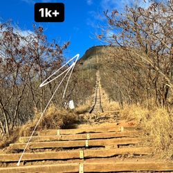
Kill me now...lol! This was our first time hiking Koko Head, and it was hard. All 1048 steps to the tippy top had my lungs on fire and my legs burning. And I'm in pretty good shape! For real though, this is a challenging, but super fun workout. It's scary, the height is no joke, but the view is 100% worth it. Really though, anyone can do it if you pace yourself. We saw people of all ages and sizes trying to summit the crater. Bring water, and try to go early. We were there just after 8am, and it was already pretty hot and crowded.

One step at a time. Believe it or not, it's harder on way down. If you choose to complete this challenge. Get shave ice in Koko marina after. The Obamas go there. The bathing suit store next door sells sun shirts, hats and stickers that say I've made it to top of Koko Head! Great souvenir to take home!


Fun hike! It's pretty linear. There's a gorgeous view of the city as you get higher and the crater head is beautiful too. Not too crowded when I went, but I can imagine that it could get very crowded and people descending could become an obstacle for people ascending and vice versa. Plenty of parking and very clean.

It's 1068 steps to the top and it's straight up. People that regularly visit or are very fit take 20-25 minutes to get to the top but it takes me just under 40 minutes from the parking lot including several breaks. I would suggest coming for sunrise and plan on getting to the top 15-20 minutes prior to sunrise. Bring a flashlight or headlamp So you can see in the dark


This is one of the most challenging hikes for me this year. There's a steady grade and then it just gets steeper as you get closer to the top. We got there around 7:30 am and it was already crowded. I do suggest going early in the morning or just before sundown to beat the heat. About halfway up, "Are we there yet?" You might feel like stopping and going back but if you've made it halfway, just keep going. They have what I called floor markers, so once it got steeper, I would take a break at each one. I don't remember stopping this much the first time I did this in 2018, but I was in better shape back then. I advise anyone who is considering climbing to at least workout on stairs, a stairmill or elliptical at least a month prior. I watched a number of people who were huffing and puffing and stopping frequently. Whatever you do, bring a small backpack or water bottle carrier because I also watched people struggle. I wore hiking shoes, but good supportive running shoes work too. I saw people wearing slippers and crocs which are not very good. I have to applaud the runners going up and down and especially this one group who had weighted bags on. They have been doing this for a while and it shows. Please be courteous and step to the side so others can pass. It is a great challenge and once you reach the top, the view is amazing! We met some really fun people! And if the couple from LA is reading this, hope you had a great trip! Koinky dink running into you at Kaka'ako!

Love the view from the top and the challenge! This will be my third time on this hike. We arrived at o'dark thirty donning our Christmas attire all alight making our way up the trail in the dark with headlamp a bright. The goal to greet the sunrise from the top. The cooler weather made for a more pleasant hike of more than a thousand railroad ties. As sky lighten we made the summit to the splendor of the golden light over the view of the mountains and ocean. Headed back down the stairs as it was growing busier with hikers of all ages, 4 to 70 of age. Do not let the age fool you, this is not a cake walk. There is no shade, knee problems-rethink, second half the steps are much steeper. If not use to it take many breaks this is a serious stair step exercise. The payoff is gorgeous views from different vantage points. Recommendations, start early, good supportive shoes, poles help going down, bring plenty of water and snacks. Go to top and relax and take in the gorgeous views.

Stair climb all the way up -- which gets even steeper and steeper. Not for the faint of heart. It took me a while before building enough courage to do Koko Head. First time was pretty exhausting. We took our time going up and down, so round trip was around 70 minutes, with going down a bit faster, and questionably easier or harder (on the knees). With that said there are quite a number of fitness people here, and one guy went up and down in 20-30 min, 3 times. For me on my first time, it took me 2 days before I could walk normally again. Fast forward to my last two trips to Oahu, and Koko Head, for some mysterious reason, is really high on my list. It's kind of fun, in a challenging and adventurous way. Its also a pretty cool bonding experience, both with you companions and with random other people you pass. You will see people huffing and puffing, people cheering others on, people zip past like they didn't realize it's a stair climb, etc. Once you climb the steps, they opened up the path on the left, so there is an additional stair climb you can do to a lookout point. If you are stair-ed out, take the path on the right which is more of your average hiking and much easier. At the top, there are multiple lookout points, so you can get a 360 degree view around. Pro-tip: Go early. my preference is 30-60 minutes before sunrise, so you can get the hard(er) part done before it starts getting hot. If you are going for sunrise, check the forecast, if its cloudy you won't see it.

I would say this is a moderate hike given the rapid incline in such a short distance. We hiked this for a sunrise hike. We had a bit later of an ideal start time but two young and in shape adults got to the top for the sunrise in 30 minutes. This hike reminded me a lot of "The Incline" in Colorado Springs but not as steep. It is railroad steps up to the top. Some people were wearing flipflops which I would not recommend. Some areas are uneven and can be slick depending on weather conditions. Be sure to bring plenty of water. Coming down was a bit tricky on the knee so be sure to pay attention. This was a nice and quick hike to start the day that didn't take up the whole day. We had no issues with parking but we parked at 5am.

This is a fantastic little "hike" and not as bad as the hype. By my calculations, it ain't all that bad by the numbers. Distance (one-way): 1/2 mile Gain: 1,000 ft 1,000 ft of gain in 1/2 mile (~2,500) is pretty steep but...it's only half a mile! If you have good mental strength, this won't be too bad. Head up at a moderate pace that you can maintain, don't worry about how slow it is, and just keep on keepin' on. You'll be at the top before you know it. If you worry about how fast other people are or count every single step: YER GONNA HAVE A BAAAD TIME! The mental aspect of this hike is that, unlike most other hikes on the island there aren't natural, built-in "rest" areas (flat sections) where you can catch a breather. It's just up the entire time. I'd also recommend NOT doing this between...say 9am and 3pm. There isn't much protection from the sun. Start really early in the morning, or go up for sunset. You'll have a much better time. I went up after dinner but before my redeye flight back to Anchorage, it was the perfect activity to end my 2-day quick-n-durty trip to Oahu! Locals are lucky to have such an efficient, and free, way to exercise. I would hit this multiple times per week if I lived on the island. This is the go-to after-work hike!

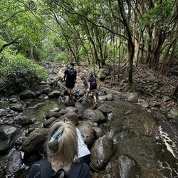
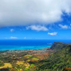
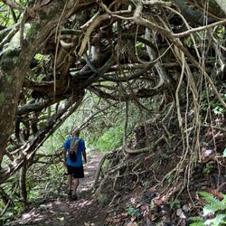
My local foodie sherpa begged me not to do this hike because of its difficulty. Her opinion was not going to be a deterrent because we had already hit up numerous eateries, and I needed to burn some calories during this trip. Besides that, I had already packed trekking poles in my check-in luggage specifically for a challenging hike while in Oahu. Three of us tackled the trek on a partly cloudy and windy Saturday afternoon. Koko Head Trail, Koko Head Stairs, Koko Head Crater, Koko Crater Stairs, Koko Crater Railway... slightly different names, but it's all the same up-and-down trail that stretches 1.8 miles with an elevation gain of just under 900 ft. The stats say there were 1,048 railroad ties, some of which have been upgraded recently thanks to the efforts of the Kokonut Koalition. We parked on a neighborhood side street because the trailhead lot adjacent to the baseball fields and playground was already full. The incline of the railway trail starts at about a 35º angle and then increases to and maintains a 45º ascent. About 3/4 of the way up, the slope feels almost vertical at 50º. There was not a lot of shade so we were fortunate with the cloud cover that day. A few bushes along the side of the tracks provided some relief. There were many points where you could stop to rest and catch your breath. Adequate water was a must-bring on this hike along with a hat, sunglasses, and sunscreen. I saw some folks wearing unstable footwear which was stupid and not recommended. About halfway up was a "bridge" that was a section in which there was no ground below the ties. If you dropped an item, then it would fall about 40 feet before hitting the ground. This part can be scary if you don't like heights. The recommendation was to crouch down and do a bear crawl while holding onto the ties to help balance yourself better. There was an alternative option of going around this area in the bush which was to the right of the track. It took us about 45 minutes to reach the summit, but it felt like more than an hour. The views in all directions were spectacular. Looking back down from where we came up, you could see how steep the railway was. To the due south were the gorgeous Hanauma Bay and its protected waters. Off in the distance to the southwest, you could see the volcanic peak of Diamond Head. Keep going further up after you have reached the end of the ties. You will encounter pill boxes that were used during wartime. Standing on top of it and looking north, you get views of Kailua and Kaneohe to the northwest and the ocean to the northeast. My poles were more useful on the way down because I could leverage them for stability as I proceeded down each step. It was easier to descend with your body turned 90º so that you were side-stepping. I saw one man going down the steps backward which was an unusual technique because he kept his body low to the ground. I joke that some trails are too flat and should be considered a walk instead of a hike. For Koko Head, this was not a hike but rather a five-star, glorified Stairmaster climb and descent.

2 months ago
Koko Head is probably my favorite trail I've done in Hawaii. Calling it a "trail" almost feels wrong though because it's basically straight-up stairs the entire way. It's short, around 2 miles total from what I remember, but it's steep the whole time and definitely not as challenging as it looks. The steps are built out of old railroad ties, so as you're climbing it almost feels like you're walking up giant rails going straight up the mountain. There's also a section about halfway through where the tracks aren't fully supported underneath anymore, so there's an open gap below you. If you missed a step there, you could definitely fall a pretty good distance. It caught me off guard the first time seeing it. I also heard from locals that people regularly have to get rescued from the top because they underestimate the hike. Apparently helicopter rides down aren't cheap either, so definitely bring water and know your limits before going up. I went early in the morning before sunrise and there were already a lot of people climbing. Once you get to the top, there are people everywhere taking pictures, relaxing, and just enjoying the view. I even saw some locals doing the hike barefoot, which honestly looked insane to me because I would never trust myself enough to do that on those steps. There are little side areas along the way where people stop to rest since the climb can get intense. Going down is interesting too because some people absolutely fly down the stairs at full speed. It took me under 30 minutes to get to the top just taking my time, but I read some people finish it in under 10 minutes somehow. The view at the top is honestly worth it though. You can see the whole area around you, and the view of Diamond Head from up there is beautiful. Definitely one of the more memorable hikes I did. read more


2 months ago
Unique hiking experience! Walking straight up a hill using the railroad tracks was cool. The drive to get here was already beautiful that it made the hike even more fun to look out from. This is medium to difficult level mostly because it's a giant stair master! There are plenty of gaps on the sides to pause and take a break while people go on. This is roughly a 1.5 hour hike altogether. We started at 9am and plenty of people were already there hiking with a full parking lot. It rained on our way back which is pretty scary since the steps get slippery. We had our hiking shoes so we were fine hiking. Just do it you won't regret the experience! Note: wear sunscreen and bug spray-we got the most bit on this hike... read more

10 months ago
How do you rate a place like Koko Head? Hike is 5 star even if I feel 1 star the whole time I'm trekking up the mountain. Let's start from the beginning. The hike has plenty of parking in the park next to the baseball fields. Once you park, you'll go towards the paved pathway to the trailhead. This isn't your typical trailhead. Instead, you look up and the entire trail is ahead of you. While it covers a very short distance, it is not for the faint of heart. The incline is a major cardio burn. Endless stairs (really about a 1000) are ahead of you. However, the stairs vary in spacing and incline. In the beginning, they are farther apart, but as you get closer to the top, they become much more steep. It's honestly a little disorienting to look up. My best tip is to just look down and move forward. About halfway through, there's a bridge section. The bridge has a pretty steep drop below and there are often bees. I always encourage taking the bypass! Much less scary and intense. It's also a nice little reprieve from the crazy stairs. At the top of the hike, there's a platform viewing area. You can also go further up either by stairs or around the side to get to a top platform. You will inevitably come across people who are either working out at the top of the mountain or who are running and doing multiple trips up and down. Don't let them deter you from continuing on! You got it. It's such an accomplishment when you finish this hike. It's such a beast but a fun challenge. read more


10 months ago
Kill me now...lol! This was our first time hiking Koko Head, and it was hard. All 1048 steps to the tippy top had my lungs on fire and my legs burning. And I'm in pretty good shape! For real though, this is a challenging, but super fun workout. It's scary, the height is no joke, but the view is 100% worth it. Really though, anyone can do it if you pace yourself. We saw people of all ages and sizes trying to summit the crater. Bring water, and try to go early. We were there just after 8am, and it was already pretty hot and crowded. read more

2 months ago
One step at a time. Believe it or not, it's harder on way down. If you choose to complete this challenge. Get shave ice in Koko marina after. The Obamas go there. The bathing suit store next door sells sun shirts, hats and stickers that say I've made it to top of Koko Head! Great souvenir to take home! read more

11 months ago
We drove by Koko head but the weather was too hot to do a climb. It's on my bucket list though. It looks so cool from below. The view from the top must look incredible. 1 day I will conquer you to the summit Kokohead. You and I have a date in the future! read more


Fun hike! It's pretty linear. There's a gorgeous view of the city as you get higher and the crater head is beautiful too. Not too crowded when I went, but I can imagine that it could get very crowded and people descending could become an obstacle for people ascending and vice versa. Plenty of parking and very clean. read more


7 months ago
It's 1068 steps to the top and it's straight up. People that regularly visit or are very fit take 20-25 minutes to get to the top but it takes me just under 40 minutes from the parking lot including several breaks. I would suggest coming for sunrise and plan on getting to the top 15-20 minutes prior to sunrise. Bring a flashlight or headlamp So you can see in the dark read more


1 year ago
Good workout! Very beautiful view! Love this hike. Sad part, if you finish your plastic water bottle or iced drink, do not leave!! Take your own trash back!! read more


This is one of the most challenging hikes for me this year. There's a steady grade and then it just gets steeper as you get closer to the top. We got there around 7:30 am and it was already crowded. I do suggest going early in the morning or just before sundown to beat the heat. About halfway up, "Are we there yet?" You might feel like stopping and going back but if you've made it halfway, just keep going. They have what I called floor markers, so once it got steeper, I would take a break at each one. I don't remember stopping this much the first time I did this in 2018, but I was in better shape back then. I advise anyone who is considering climbing to at least workout on stairs, a stairmill or elliptical at least a month prior. I watched a number of people who were huffing and puffing and stopping frequently. Whatever you do, bring a small backpack or water bottle carrier because I also watched people struggle. I wore hiking shoes, but good supportive running shoes work too. I saw people wearing slippers and crocs which are not very good. I have to applaud the runners going up and down and especially this one group who had weighted bags on. They have been doing this for a while and it shows. Please be courteous and step to the side so others can pass. It is a great challenge and once you reach the top, the view is amazing! We met some really fun people! And if the couple from LA is reading this, hope you had a great trip! Koinky dink running into you at Kaka'ako! read more


Love the view from the top and the challenge! This will be my third time on this hike. We arrived at o'dark thirty donning our Christmas attire all alight making our way up the trail in the dark with headlamp a bright. The goal to greet the sunrise from the top. The cooler weather made for a more pleasant hike of more than a thousand railroad ties. As sky lighten we made the summit to the splendor of the golden light over the view of the mountains and ocean. Headed back down the stairs as it was growing busier with hikers of all ages, 4 to 70 of age. Do not let the age fool you, this is not a cake walk. There is no shade, knee problems-rethink, second half the steps are much steeper. If not use to it take many breaks this is a serious stair step exercise. The payoff is gorgeous views from different vantage points. Recommendations, start early, good supportive shoes, poles help going down, bring plenty of water and snacks. Go to top and relax and take in the gorgeous views. read more


Stair climb all the way up -- which gets even steeper and steeper. Not for the faint of heart. It took me a while before building enough courage to do Koko Head. First time was pretty exhausting. We took our time going up and down, so round trip was around 70 minutes, with going down a bit faster, and questionably easier or harder (on the knees). With that said there are quite a number of fitness people here, and one guy went up and down in 20-30 min, 3 times. For me on my first time, it took me 2 days before I could walk normally again. Fast forward to my last two trips to Oahu, and Koko Head, for some mysterious reason, is really high on my list. It's kind of fun, in a challenging and adventurous way. Its also a pretty cool bonding experience, both with you companions and with random other people you pass. You will see people huffing and puffing, people cheering others on, people zip past like they didn't realize it's a stair climb, etc. Once you climb the steps, they opened up the path on the left, so there is an additional stair climb you can do to a lookout point. If you are stair-ed out, take the path on the right which is more of your average hiking and much easier. At the top, there are multiple lookout points, so you can get a 360 degree view around. Pro-tip: Go early. my preference is 30-60 minutes before sunrise, so you can get the hard(er) part done before it starts getting hot. If you are going for sunrise, check the forecast, if its cloudy you won't see it. read more


1 year ago
I would say this is a moderate hike given the rapid incline in such a short distance. We hiked this for a sunrise hike. We had a bit later of an ideal start time but two young and in shape adults got to the top for the sunrise in 30 minutes. This hike reminded me a lot of "The Incline" in Colorado Springs but not as steep. It is railroad steps up to the top. Some people were wearing flipflops which I would not recommend. Some areas are uneven and can be slick depending on weather conditions. Be sure to bring plenty of water. Coming down was a bit tricky on the knee so be sure to pay attention. This was a nice and quick hike to start the day that didn't take up the whole day. We had no issues with parking but we parked at 5am. read more

This is a fantastic little "hike" and not as bad as the hype. By my calculations, it ain't all that bad by the numbers. Distance (one-way): 1/2 mile Gain: 1,000 ft 1,000 ft of gain in 1/2 mile (~2,500) is pretty steep but...it's only half a mile! If you have good mental strength, this won't be too bad. Head up at a moderate pace that you can maintain, don't worry about how slow it is, and just keep on keepin' on. You'll be at the top before you know it. If you worry about how fast other people are or count every single step: YER GONNA HAVE A BAAAD TIME! The mental aspect of this hike is that, unlike most other hikes on the island there aren't natural, built-in "rest" areas (flat sections) where you can catch a breather. It's just up the entire time. I'd also recommend NOT doing this between...say 9am and 3pm. There isn't much protection from the sun. Start really early in the morning, or go up for sunset. You'll have a much better time. I went up after dinner but before my redeye flight back to Anchorage, it was the perfect activity to end my 2-day quick-n-durty trip to Oahu! Locals are lucky to have such an efficient, and free, way to exercise. I would hit this multiple times per week if I lived on the island. This is the go-to after-work hike! read more


My local foodie sherpa begged me not to do this hike because of its difficulty. Her opinion was not going to be a deterrent because we had already hit up numerous eateries, and I needed to burn some calories during this trip. Besides that, I had already packed trekking poles in my check-in luggage specifically for a challenging hike while in Oahu. Three of us tackled the trek on a partly cloudy and windy Saturday afternoon. Koko Head Trail, Koko Head Stairs, Koko Head Crater, Koko Crater Stairs, Koko Crater Railway... slightly different names, but it's all the same up-and-down trail that stretches 1.8 miles with an elevation gain of just under 900 ft. The stats say there were 1,048 railroad ties, some of which have been upgraded recently thanks to the efforts of the Kokonut Koalition. We parked on a neighborhood side street because the trailhead lot adjacent to the baseball fields and playground was already full. The incline of the railway trail starts at about a 35º angle and then increases to and maintains a 45º ascent. About 3/4 of the way up, the slope feels almost vertical at 50º. There was not a lot of shade so we were fortunate with the cloud cover that day. A few bushes along the side of the tracks provided some relief. There were many points where you could stop to rest and catch your breath. Adequate water was a must-bring on this hike along with a hat, sunglasses, and sunscreen. I saw some folks wearing unstable footwear which was stupid and not recommended. About halfway up was a "bridge" that was a section in which there was no ground below the ties. If you dropped an item, then it would fall about 40 feet before hitting the ground. This part can be scary if you don't like heights. The recommendation was to crouch down and do a bear crawl while holding onto the ties to help balance yourself better. There was an alternative option of going around this area in the bush which was to the right of the track. It took us about 45 minutes to reach the summit, but it felt like more than an hour. The views in all directions were spectacular. Looking back down from where we came up, you could see how steep the railway was. To the due south were the gorgeous Hanauma Bay and its protected waters. Off in the distance to the southwest, you could see the volcanic peak of Diamond Head. Keep going further up after you have reached the end of the ties. You will encounter pill boxes that were used during wartime. Standing on top of it and looking north, you get views of Kailua and Kaneohe to the northwest and the ocean to the northeast. My poles were more useful on the way down because I could leverage them for stability as I proceeded down each step. It was easier to descend with your body turned 90º so that you were side-stepping. I saw one man going down the steps backward which was an unusual technique because he kept his body low to the ground. I joke that some trails are too flat and should be considered a walk instead of a hike. For Koko Head, this was not a hike but rather a five-star, glorified Stairmaster climb and descent. read more


Steep hiking trail. First time I had thrown up in my adult life. It was an exhausting but rewarding experience. Go at your pace and don't hike when you're exhausted and could miss a step. Water is a must. My boyfriend had forgotten his backpack at the top of the trail and realized when we were half way down. So please don't do that. The view is breathtaking. It captures so much of the island. You'll just need to see it for yourself. read more


2 years ago
Very tough straight up hike/stairs. Arrive early before the heat/sun. Kind of difficult to get to by bus. It took us around 2 hours from Waikiki and we had to walk a mile to the trailhead. The elevation increase near the top was quite intense. I ended up getting exhausted and light headed and gave up around 2/3 of the way due to the heat and low oxygen at the higher elevation. I'm sure if the bus wasn't delayed and we got there earlier it would've been more doable. read more


This is a serious exercise hike after about a quarter mile of walking you start to go up some railroad tracks which are the equivalent to about 55 flights of stairs I only recommended doing it in the earlier part of the day, or the very last part of the day there are good views up on the top. Generally speaking it has a I didn't on Sunday morning and I thought I had a good vibe overall do not go there when it's wet it would be very slippery. read more

2 years ago
Climbing this was probably the highlight of my trip. Not sure what the operating hours were but I went there at 9:30pm, yup in the dark, with nothing except the moonlight illuminating part of the trail. I also had 4 beers. The decision to go at night was probably the alcohol telling me to be dumb but adventurous. Side note, did not drive myself there. Anyways it took me, my friend and my gf about 1.5 hours to climb to the top. To see the moon and stars at the top was beautiful to say the least. It was a little harder to climb down cause I was wearing converse shoes and being 40 yrs old. :/ Saw a police car on the way down near the entrance and they just waved at us. So I believe it's ok to go at night? read more


The hardest hike ever but hella rewarding. No railing and super steep. Not sure if walking sticks would even help you. There are honestly some beasts that come out here and just run up and down like it's nothing. One little older lady lapped me like 3x! haha! There are little sides where you can stop and take a breather but if a group is already there, keep going until you find another one. Please show etiquette and don't stop in the middle as people are bypassing others and you have the other side of people coming down. In one part of the hike, there is no bottom but you can bypass this by going on the side through rocks and trees, it's very short. Everyone is part of the same journey so be courteous and kind. Be mindful of the locals and get out of their way as this is their regular workout and they will be speedy. Bring hella water, take your time, and stretch! Quad juice explosion everywhere! read more


Located near Kamala, this hill/mountain provides a nice hike up to the top with assumed views of the City and ocean, as I did not want to hike straight up during the mid-day heat. There is parking at the base of Koko Head, with a baseball field and recreation buildings close by. If you're looking for buns of steel, this would be a nice workout early in the morning. People coming down the mountain looked pretty happy, with a nice glow to their faces... read more

4 years ago
22 January 2022 #5 - That's the number of times I have done Koko Head hike since I have been living on Oahu since 2019 (low compared to those who do it 5 times in a single day!). I can definitely tell that my stamina and speed have improved over the 5 times I have done the hike. Not only is going up hard and steep at some spots, going down is also tricky, and should be done cautiously. Added to my personal growth, the restoration and repair work done by the volunteers of the Kokonut Koalition has drastically improved the safety aspect of the trail/stairs. My "capable" family, friends, and I always take some supplies up when they are out. I think the hike is doable for any able-bodied person, regardless of age or physical activity level. It's hard and mentally challenging but doable! My 63-year-old breast cancer survivor mother has done it 2 times (2021 & 2022) since having surgery (2020), and she is not a very active person. I say this as a way to encourage those doubting their abilities. You can do it! read more


3 years ago
The google landmark won't take you to the starting point for the hike so look up "Koko Head Trailhead Parking Lot" instead. Very short but extremely tough hike with an extremely rewarding viewpoint at the top. Took me 36 minutes to get to the top and I went relatively fast so pace yourself and most importantly bring water and sunscreen. People of varying athletic abilities were all able to make it to the top so you can too. It was crazy to see people going up and down multiple times. It's a hike where you go up steps that are old railroad tracks. At one part the tracks detach from the ground and I had to crawl up; on the way down I walked. Some may say it is worse on the way down. Met some interesting people on the hike and most people are super friendly and supportive. read more


5 years ago
Do you like the Stairmaster? Well, get ready to meet the Stairmaster from hell. The Koko Head hike will definitely have your legs and thighs feeling the burn as you climb the 1,000+ steps to reach the top. The 360 panoramic views of Hawaii-kai, Hanauma Bay and more are well worth it, if you can handle its intensity. This is an intermediate to advanced hike and you should be in a decent shape to attempt this. I'd rate this at around a 6/10 difficulty level. Starting out, the hike up isn't too bad, as the recent additions of gravel have filled out the gaps between the steps, making it easier. However, some parts are definitely harder than others and it's when you reach the halfway point when you have the option of taking either the bottomless stairs or the detour where it starts getting tricky. Hint: if you're scared of heights, you should probably take the detour. I wanted to attempt going up the steps but one look down into the drop off, my inner chicken emerged. Luckily, this only lasts around 45ish steps and then you're back on the regular dirt and gravel steps. Once you reach the top, you have a few different pillboxes and lookouts you can take photos from. While you may think going up is hard part, getting back down is where the real challenge begins. Some of the steep, uneven steps will have you walking sideways or using your hands to push your butt down to gain a better foothold. Make sure you are careful and do this slowly. And be aware of loose dirt and gravel, lest you slip, fall and land on your lower back like I did. Still feeling the bruise as I write out this review. Take plenty of breaks in between, bring enough cold water, and make sure you wear plenty of sunscreen due to the lack of shade and you'll have one amazing experience here at Koko Head! read more
 - Hiking Near Me - Honolulu, Hawaii")

2 days later, I still can't feel my legs... Jk, but this hike is like doing the stair master 2.0 It's no joke, 1048 stairs up and can get pretty steep. I recommend bringing water of course, as it can get hot depending the time of day. Besides that I still recommend bringing water to any hike. The hike only takes about 1.5 hours or less depending how many stops you take and how long you stay up top. I went with my girlfriend and the views were amazing. But of course she is still my best view. Overall, I suggest you go early, so it doesn't get too hot. Lots of parking and it's free which is always a good thing. read more

3 years ago


Ok ok ok I was actually really dreading this hike Bc I'm super out of shape But it wasn't that bad! Just take your time and make sure you hydrate and it's totally doable There's a portion where there's no ground underneath the (~30) steps but there is a bypass if that ain't your thing Going down was much faster, but also rough on my knees Felt so accomplished although my legs were jello Get there early to beat the sun! read more


Koko Head trail is 1048 steps straight up, around 1.4 miles RT. It is definitely a challenging hike, but so rewarding once you get to the top! Just make sure you pace your steps, and just as importantly, your breathing! I took plenty of breaks going both up and down. It took us around 25 min to get to the top. The views are so worth it! 360 views of Oahu below, including Hanauma bay, the crater, and Diamond Head. It started sprinkling a bit when we were at the top, and we found ourselves at eye level with a rainbow! Amazing. There is no shade on this climb, so make sure to bring a hat, SPF, sunglasses. Get ready to feel the burn and proud of yourself once you've made it to the top! read more

5 years ago
This trail is intense but awesome. My roommate wanted to watch the sun set from the top of the trail, which we did. In theory that sounds like a blast, right? It is! Only issue is going down, in the dark, so freaking scary! But it really is a great workout and a beautiful view and I can't wait to do it again one day! And if you're a fan mod the television show Lost, you'll be stoked as you can see the Flame Station from this trail. I totally nerded and took A few selfies with the filming location behind me. Bring water with you, but I'd find a way to be hands free. And try to beat the sun going down. read more


Page 1 of 7
More info about Koko Head
423 Kaumakani St
Koko Head District Park
Honolulu, HI 96825
Hawaii Kai
Directions
Hours
Indoor Amenities
Outdoor Amenities
Koko Head Reviews in Other Languages
Ask the Community - Koko Head
Would you bring toddlers?
Unfortunately, this is not for toddlers in my opinion.
What are the hours for parking, am & pm?
Review Highlights - Koko Head
You might also consider


Why does Yelp recommend reviews?
4 reviews that are not currently recommended
The reviews below are not factored into the business's overall star rating.
2 years ago
1 year ago
2 years ago
Koko Head - hiking - Updated July 2026
Best of Honolulu
People found Koko Head by searching for…
Night View in Honolulu, Hawaii
Off Road Trails in Honolulu, Hawaii
Abandoned Places in Honolulu, Hawaii
Dog Friendly Beaches in Honolulu, Hawaii
Night Hike in Honolulu, Hawaii
Natural Hot Springs in Honolulu, Hawaii
View Points in Honolulu, Hawaii
Scenic Overlook in Honolulu, Hawaii
Swimming Holes in Honolulu, Hawaii
Flower Fields in Honolulu, Hawaii
Full Moon Hike in Honolulu, Hawaii
Places to Take Pictures in Honolulu, Hawaii
Stargazing in Honolulu, Hawaii
Hiking Trails in Honolulu, Hawaii
Fishing Spots in Honolulu, Hawaii
Bamboo Forest in Honolulu, Hawaii
Sunrise View in Honolulu, Hawaii
Dog Friendly Parks in Honolulu, Hawaii
Abandoned Buildings in Honolulu, Hawaii
Dog Friendly Hiking Trails in Honolulu, Hawaii
Sunrise Hike in Honolulu, Hawaii
Trending Searches in Honolulu, HI
Browse Articles
Browse Nearby
BEST of Honolulu, Hawaii Coffee near Koko Head
BEST of Honolulu, Hawaii Restaurants near Koko Head
BEST of Honolulu, Hawaii Things to Do near Koko Head
BEST of Honolulu, Hawaii Parks near Koko Head
BEST of Honolulu, Hawaii Breakfast near Koko Head
BEST of Honolulu, Hawaii Campgrounds near Koko Head
BEST of Honolulu, Hawaii Walking Trails near Koko Head
Browse Brands
Related Searches in Honolulu, HI
Affordable Kayak Rental Services in Honolulu, Hawaii
Best Fishing Locations and Guides in Honolulu, Hawaii
Best Nature Trails for Hiking in Honolulu, Hawaii
Best Places for Horseback Riding in Honolulu, Hawaii
Best Waterfalls and Swimming Holes in Honolulu, Hawaii
Check Out Off Road Trails in Honolulu, Hawaii
Discover Dog Friendly Trails to Explore in Honolulu, Hawaii
Discover Kid Friendly Hiking Trails in Honolulu, Hawaii
Discover Scenic Hiking Trails in Honolulu, Hawaii
Discover Scenic Waterfall Spots in Honolulu, Hawaii
Discover Walking Parks in Honolulu, Hawaii Near You
Discover a Hiking Trail in Honolulu, Hawaii
Discover the Best Night Hike Trails in Honolulu, Hawaii
Dog-Friendly Hikes With Dogs in Honolulu, Hawaii
Enjoy Camping Adventures Around Honolulu, Hawaii
Enjoy Kayaking Adventures in Honolulu, Hawaii
Enjoy Tent Camping Spots Around Honolulu, Hawaii
Enjoy a Beautiful Waterfall Hike in Honolulu, Hawaii
Enjoy a Peaceful Nature Walk in Honolulu, Hawaii
Enjoy the Best Picnic Spots and Ideas in Honolulu, Hawaii
Enjoy the Best Walking Path in Honolulu, Hawaii
Enjoy the Best Walking Trails in Honolulu, Hawaii
Exciting Cliff Jumping Spots in Honolulu, Hawaii
Explore Beautiful Parks and Green Spaces in Honolulu, Hawaii
Explore Easy Hikes Perfect for All in Honolulu, Hawaii
Explore Fun Activities to Do in Honolulu, Hawaii
Explore Popular Campgrounds Near Honolulu, Hawaii
Explore the Best Beach Spots in Honolulu, Hawaii
Explore the Best Swimming Holes Around Honolulu, Hawaii
Explore the Best Trail Options in Honolulu, Hawaii
Family Friendly Hiking With Kids in Honolulu, Hawaii
Find Popular Ziplining Spots Around Honolulu, Hawaii
Find the Best Parks for Picnics in Honolulu, Hawaii
Find the Best Scenic View Locations in Honolulu, Hawaii
Great Places to Walk in Honolulu, Hawaii
Hike the Popular Waterfall Trail in Honolulu, Hawaii
Hiking Trails With Waterfalls in Honolulu, Hawaii
Off Leash Dog Hiking Trails in Honolulu, Hawaii
Plan a Scenic Drive Route Near Honolulu, Hawaii
Popular Outdoor Activities to Try in Honolulu, Hawaii
Popular Picnic Spots to Visit in Honolulu, Hawaii
Safe River Swimming Areas in Honolulu, Hawaii
Safe and Fun Parks for Kids in Honolulu, Hawaii
Top Climbing Spots and Gyms in Honolulu, Hawaii
Top Paddleboarding Activities in Honolulu, Hawaii
Top Places for Snorkeling in Honolulu, Hawaii
Top Running Trails to Explore in Honolulu, Hawaii
Top Swimming Spots and Pools in Honolulu, Hawaii
People who viewed Koko Head also viewed
Lulumahu Falls
360 reviews
Makapu'u Point Lighthouse Trail
1101 reviews
Diamond Head State Monument
2241 reviews
Diamond Head
Makiki-Manoa Cliffs Hike
38 reviews
Mānoa Falls Trail
1267 reviews
Palolo Valley
12 reviews
Lanipo Trail
28 reviews
Pu'u Manamana Hiking Trail
70 reviews
Moanalua Middle Ridge
42 reviews
Crouching Lion Hike
12 reviews