Moanalua Middle Ridge Photos


You might also consider
More like Moanalua Middle Ridge
Recommended Reviews - Moanalua Middle Ridge
Start your review...

Reviews With Photos

5/8/19 6:45 am. 2lwe started the hike from the parking lot at the Moanalua Valley. Facility has clean bathroom and extra water faucet to wash off. Met local gentlemen who was coming down from the hike. He said river bed is dry meaning, no rain. Awesome! There is confusion between Moanalua Valley and Moanalua Middle Ridge. They are two different hikes but one must do the Valley first to get to the Middle Ridge. The Valley hike is mostly flat with gentle incline and wide road. After reading many reviews and seeing some YouTube videos, we were ready for it. I even had screen capture of directions on my phone. Dont get confused of getting on the Moanalua Middle Ridge Trail from Moanalua Valley Trail. See my photo of Kulana'ahane Trail sign. Stop at the sign and look across the creek. You will see the trail and small brown wooden sign 10 feet off the ground. If you can't see it, just cross the creek from the sign and get on to the trail. You will see the wooden sign and also fallen tree with trail engraved on it. If you are able to see the sign, you are on right trail and it will start ascending very quickly. Lot of other says not to cross the creek at this point and look for either pink ribbons, large rock or peelings tree bark. Over time, they have changed or hard to spot them. The direction on "Alltrails" are vague about the critical turning point. Cell reception: Xfinity mobile was excellent. I was able to make phone calls throughout the hike. Mileage tracker: I used free version of Endomondo which was very helpful on tracking my progress. About 3 miles was done on wide gravel road. When the wide road turns into narrow single track and haven't crossed creek, you have passed the Kulana'ahane Trail sign. When you cross the creek at the sign, it's all on narrow ridge road hiking up with rapid accent. Good luck and you will be awarded with amazing views. Fitness level: dont get confused with leasurly hiking on the four wheel drive road. Actual Middle Ridge trail are narrow, slippery and 100 to 1000 feet drop on each side. Water: hiking thru humid condition definitely requires more hydration. Adjust accordingly for 7 -10 hour hike. Once you cross the creek, you do not have water source.

Hard hike but lots of people are on it. My husband and I hike often and consider ourselves in shape. We don't really take a break while we hike and it took us 5 hours to get to the stairway and back to the bottom (includes quick stops for pictures, water, snacks). There wasn't water in the ridges so we were able to do it pretty fast. Didn't have spikes or gloves and you definitely don't need them if it's not wet out there. Bring sunscreen, water, and snacks. Be sure to watch YouTube videos on where to turn. There's 1 turn that's not marked and could as to an hour detour if you miss it. Our watches said it was 10.2 miles total. There were helicopters flying by to make sure people weren't hiking on the stairwell.

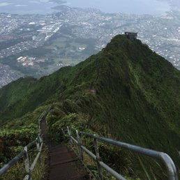
If you're looking to check Stairway to Heaven hike off your bucket list, this is one of the legal routes to do it! The longest, most strenuous, and hardest hike I have done! Things to Do: 1. Download the AllTrails app!!!! This is what saved our butts from not getting more lost. Awesome app that can pinpoint pretty precisely where you're at on the map, even without cellular signal (you'll have to pay for a whole year subscription of about $30, but trust me, it's worth it to not get lost especially having to climb up that ridge, you'd want to save up all the energy you have for it). Just make sure you stay on the trail according to the map and you'll be golden! 3. Plan for a minimum of 8hours round trip, including time that you want to spend once you reach the top. Don't start any later than 10am. You want all the day light time you can get. We are not the fittest people with 6 pack or anything, but I want to think we're pretty fit, still took us almost exactly 8hrs 4. Pack a minimum of 1.5-2Liters of water/person, and some light snacks. There are plenty of strawberry guava especially at the beginning of the ridge. Don't depend on them much since they seem to be loved by a lot of hikers too. 5. BRING GLOVES!!!There's a bit of rock climbing you'll have to do, literally. There are ropes already tied up by the kind hearted previous hikers, where it's extremely inclined. Whoever you are, thank you, thank you!!! 6. Get some shoes spikes. They're not a must (we tried to get some right before arriving here, but couldn't find any at the nearby Walmart so decided to go without). The ridge trail can have a lot of rolling dirt and pebbles. The spikes will for sure give you some extra grip. 7. Go early around 7-8am if you want to secure a parking spot right at the park. Otherwise, plan to park further away on neighborhood streets. 8. Bring headlight if you're planning on starting super early or staying late to catch the sunset. You will definitely need it to go down that ridge. 9. A GoPro would be perfect to capture some or all of the hike. You want to keep your hands free for some part of the ridge that you'll literally have to be on all 4 to climb up. 10. Bring a sweater and some rain gear. It gets extremely windy and at least 15-20 degrees cooler once you get to the top. It's also very common for the rain to come and go quickly (even tho the weather forecast in the general area might say sunny all day). Here's a summary of our experience: We put in the GPS the address of Moanalua Valley Neighborhood Park at "1857 Ala Aolani St, Honolulu" as the starting point for our hike. There's a small parking lot (enough for maybe 10 cars top) right in the park, but a lot of locals come here to walk the park trail, along with the ridge hikers, so be prepared to park on the neighborhood street. There are pretty much 2 main parts to this hike. First park is the walk in the park that's nothing like "a walk in the park". It's about 2.5mile long, with a small part (maybe 20-30 feet) that can get very muddy. Look for any nearby "trails" when you get to that muddy part. It'll help a lot if you don't want to start climbing the ridge with heavy muddy shoes. Most hikers who get lost trying to hike this ridge, get lost close to the end of this walk in the park. Once you have walked about 2.3miles or so (my number might be a bit off), the trail seems to end at the dry (or wet? When it rains) river bank. DO NOT try to cross over and CLIMB UP one of the trails you might see. If it requires any almost vertical climbing, you're heading the WRONG WAY!!! This is speaking from experience unfortunately. We climbed our butts up one of these trails, almost fell and broke couple bones or more, only to realize we were going the wrong way after almost 20-30mins. Get on that dry (or wet) river bank, but continue down along it. If you have the AllTrails app, stay on the trail in the app and you're good. If you don't have the app, there will be locals who come here to walk this trail (not climbing the ridge), ask them. Again, don't attempt to climb up any crazy trails you might see. They're NOT the one! About a quarter a mile after that point, you'll know you're on the right path when you come across a clearly marked sign "KULANA'AHANE TRAIL" and "Flash Flood" warning on your left hand sign. DO NOT turn here, keep going another 20-30ft until you see a huge rock with some rock balancing on top in the middle of the river bank. There's a tiny trail across that, get on it. This is the 2nd and final part of this hike (1 way of course). The trail will open up more and lead you all the way to the top. Once you get on this ridge trail, there's NO WAY you'd get lost. Just prepared to keep ascending the next 2 hours or so until you get to that iconic radio tower. Whoever reading this review and got this far, thank you! lol Hopefully my review has cleared up some of your worries and prepared you for this crazy but rewarding hike! ;)

Of all of the paths, you take in life make sure a few of them are dirt... I would definitely say I'm a hiker. I am an experienced hiker. I hike in every city I'm in. I've hiked Half Dome at Yosemite National Park and Angels Landing at Zion Park. These are some of the scariest hikes you can do and they are both pretty tough to say the least. I'm gonna try to keep it in bullet points so it's easier to read for people that want to take a quick look. Things you need to know: -An advanced hiker might be able to do this in six hours however 8 hours is going to be more likely because of the weather conditions. Mud, rain, and wind will slow you down! -It's easy to get lost because the signs are not clear to get up to the stairs. (I had to stop many times to make sure I was on the right route and got lost once and I'm pretty bright.) I heard many people get lost. -After a few days of rain, it's super muddy and you won't be able to walk on the trail so you will have to find other routes unless you want to sink in the mud. And when I say sink I mean it in some spots you could possibly sink all the way up to your calves. I felt like a monkey trying to hang off the trees to not sink in the mud. Note: I have very expensive hiking boots. -It was super windy when I went so the wind might slow you down. Hold on to the rope when it's windy. Seems obvious but the wind can sneak up on you. -The hike is long and steep which I like but I started at 12ish and that was too late. I thought it was too dangerous to go down the steep ridge in the dark. With great weather conditions, and a direct trail I probably could've made it up at 3 or sooner but because of all the reasons listed above I got up to the top at 3:45. Then it took me another 15 minutes to get to the stairs because it was so muddy and steep. I was sinking into the mud and I just wasn't prepared for these conditions. I guess I wasn't as bright that day because this was a pretty stupid decision. -Scaredy cats don't apply. This might be obvious but if you're scared of heights you definitely do not want to do this hike. If you do you might just pee in your pants. This is a great hike if you want a good workout. Common sense things would be...wear great hiking shoes, do it early enough so you don't end up in the dark. I don't think there's a huge necessity for food. I brought one large bottle of water and it was fine. My biggest problem was not having enough time in the light to get down without getting lost and the mud. Even though it hadn't rained that day it had lightly rained the day before and the day before that. If you do this hike and it's not muddy, go with somebody who knows the route, and you're in amazing shape then you could probably knock this hike out in three hours each way. For other people, I would give yourself four or more hours each way so at least eight hours round-trip. My only reason for giving 4 stars is because the trails don't have clear signs to get up to the stairs. The views at the top are definitely 5 stars worthy. I would hike this beast again but I would be better prepared next time! Sometimes you take a walk in the woods and come out taller than the trees...that's Moanalua Middle Ridge!
DON'T follow my example and only get 2 hours of sleep the night before attempting this beast. It's around 4 hours one way, and a lot of it is intense! DON'T wear your cutest pair of leggings, you will get dirty. There are parts of the trail that are muddy, probably 365 days/year. DO go with someone who has already conquered it. Along the trail, we encountered several individuals who had turned around/started over after they found themselves on an even more treacherous route. Lopaka H., two friends visiting from California, and myself began our adventure at around 7:30am. We took a few breaks along the way, to re-fuel and take photos. I brought 2 liters of water, but I suggest more if possible. Interesting fact: I didn't have to pee at all the entire time, and I drank all the water I brought. Was it exuded as sweat, tears, or drool?! Probably all of the above (haha just kidding) but mostly sweat. This is a hike that will test you mentally and physically. I train 6-7 days/week and think I'm in decent shape, and thought it was challenging. The sheer duration and incline caused cramps in my legs. There are sections of the trail that will require you to put your trust in the strength of some sketchy looking ropes. I had gloves and spikes, which helped a lot. Also, don't forget to bring any medication(s) that you may need. I am prone to headaches, and got one around 3/4 of the way up. Despite the challenges presented, the risk was definitely worth the experience. The views are gorgeous, I recommend taking as many photos as safely possible, the camera in your mind will thank you one day. I will return to this ridge, armed with more than a few hours of sleep and adequate hydration, and hopefully when the bruise on my toe finally subsides.

First of all let me say that anybody tells you that this hike is a beginners hike is an absolute lie, it is not. Maybe at the beginning the first hour or so it is more of a walk but once you get past a certain point be prepared. It is one of the most difficult hikes that I have ever done and I did the spartan trifecta in one weekend here in Hawaii. I was tricked into thinking this was a beginners hike so I was extremely surprised. I didn't make it up to the top we made it to about the midway point which is 2,109 feet up in the air. The wind was so bad and the clouds were coming down so it was unsafe for us to continue. That brings me to the hike down, which is by far harder than going up the rocks are slippery a lot of 90° angles the ropes that are in place are helpful but deceptive so you have to be extremely careful. If there's any type of precipitation out there you may as well just find a place to camp because it is close to impossible to not get hurt going down if it's raining. Now to the good part the views were absolutely breathtaking and I can only imagine what the views are from the complete peak, which I do plan to try to see again when I am more mentally prepared. It is at least a nine hour hike because that is how long it took for us just to get to the halfway point that's round-trip. So I'm thinking probably about five hours all the way to the top in five hours down so it's going be at least a 10 hour hike so go early. Bring plenty of water with you and a flashlight or head lamp in case you get caught in the dark. Please pay attention to the weather reports when it comes to wind advisories because on that ridge there are no trees there is nothing to hold on to. if you were to get a huge gust of wind it is extremely dangerous. When were descending, we saw several medivac helicopters going to rescue people who had fallen and or had gotten lost so just be careful. The pictures are great but they don't do the beauty justice. This is an honest review from a novice hiker but an athlete. Definitely a bucket list hike.

Moanalua middle ridge to Haiku stairs (stairway to heaven) Best hike I've ever done. I'll Try and be as detailed as possible to help especially with info on exiting the haiku stairs. I've divided the hike into 4 sections hope it helps somebody. Section 1. The start We Started the moanalua middle ridge track at the park at the end of Alo aolani St. We Walked through the gate at 7:45am. Terrain initially is good, shade was great. TRUST in the path, don't go off it into the few tempting paths that stem from it. You will cross the stream around 14 times and walk for approximately an hour before you reach the sign for the Kulana'ahane Trail. As per previous reviews the trailhead for middle ridge is a few steps past this sign. As of March 6, 2017, this entry to the middle ridge trail was marked with a pink ribbon. You now begin a trek through the forest as your body switches gears from flat walking to hiking/climbing through trees and so on... Section2. The ridges and rope climbs You'll trek through ridges going up and down for about an hour and a half. nothing too dangerous YET, I always felt safe as long as I was careful. There were a few rope climbs but they were easy and I'm not upper body strong. Hardest thing for this section is just the will to keep going, but the views start to present themselves and they just keep getting better. Eventually you'll see a long rope climb ahead with multiple ropes to help get climbers up. These held my weight and I'm 130Kgs. Once you make it up this rope climb and a few more ridges the tower will present itself. Congratulations, when you first see the tower your only 30-45mins away from the stairs but be warned, it now gets technical! Section 3: the Tower The tower is a teaser, but more importantly it's a sign that the technical part of the hike is now upon you. The track changes to a more muddier (if possible) steep, and arduous terrain. Take your time and be careful. There are paths that are on an angle and narrow so be careful. Eventually You will reach a rope climb that is longer than the others. If you don't have gloves are if your unsure of your ability, twist the rope around one arm while climbing. When you reach the top here it's a matter of navigating the twisting freaky pathways. Do NOT trust the trees covered in moss. They won't hold you. Track is muddier and steep leading to the end. Highway makes itself visible to your right but don't lean over too much. A final climb and you've reached the stairs. Well done! This portion of the hike for two people takes around 3.5-4hours. We enjoyed the top and took photos and decided to go down the stairs to complete the loop. We went down the stairs in about 1 hour (45mins really but Wifey kept taking photos). Section 4: Exiting the Haiku Stairs When you get to the bottom of the stairs there is a gate, go around this gate. You'll see a fence in front of you with a hole in it, go through this hole. You will come out and be exposed to the guard. We walked straight ahead, straight past the guard to a hole in the fence slightly to the left. Go through this hole, be careful of the barbed wire. You will come to a mud slide going down with lots of rubbish. Use the bamboo to get down safely. Once at the bottom, you'll come out onto a street (remember your in private property on this street and all the way until you make it out to the houses). Turn LEFT (DO NOT TURN RIGHT AND WALK THROUGH SCHOOL) and walk down a short distance then turn right. Once you turn right, you will walk for 15-25mins until you come to the gate. If it is closed you'll have to find a way through somehow. It was opened when we went through around 1:45pm so it was an easy exit. You are now in the neighbourhood. No hassles from neighbours but we were respectful and quiet walking through. From here you may opt to get an uber/taxi but we decided to continue down path on the left to the pre-school where we got our uber from. We took an uber back to Alo Aolani st, which was 20mins and cost us $26USD. Weather was ideal for this hike, little wind, no rain and ground ha dried from the rains 2 days before. I can see how this hike can be dangerous with those elements added. It was so satisfying doing this hike from the ridge more so than if we did it from the stairs. The views were amazing, and trekking through made it that much more satisfying! Happy hiking peeps.

FINALLY had a chance to do Middle Ridge and it wasn't nearly as crowded or hard as I thought it was going to be. Obviously novice and unprepared hikers may struggle, but intermediate hikers with good stamina and the right equipment (gloves, spikes, water, food, sunblock, rain shell) will find it a walk in the park. My friend and I are both distant hikers and in great shape; with spikes and gloves in tow we made it to the top in under 3hrs and that's with no breaks and a few turn arounds. Yep...the hardest part is finding the turn off because we kept second guessing ourselves. As the other Yelpers said, travel the Moanalua Valley Trail for about 1hr/3miles, pass the Kulana'ahane Trail sign and turn left across the dry stream bed. You'll see a tree with Middle Ridge carved in it and you'll know you're headed the right way. The rest of the trail is self explanatory. And if you're one of the many to find FOG and NO view up top, walk 20minutes down the stairs to find AMAZING views! Trek on Yelpers!

One of my favorite Oahu hikes. I'm surprised there aren't more reviews since this is the safest, legal way to the Haiku Stairs. People say this trail is sketchy so I'm guessing they're talking about the shoulder-width ridge parts to the top. Don't get me wrong, it is one of the more challenging & varied hikes I've done (and I hike hard trails quite a bit). The trail is long (a little over 12 miles round trip) & the first 3-ish miles are boring since you're walking along a flat yet rocky road to the trailhead (a couple feet past the Kulana'ahane Trail sign on the left). The trailhead is extremely easy to miss! It's just a small opening after the sign & you cross what looks like a dry creekbed. The trail incline goes up pretty sharply after you cross the first streambed. Get yer glutes ready. We did this hike during very un-ideal conditions - especially for a ridge hike. The wind gusts were up to 30 MPH & at times, we had to clutch a random bush to stabilize ourselves as we waited out these gusts. We also got rained on. The trail itself was surprisingly pretty dry but the loose gravel made it so slippery. We each fell a couple of times on the way down. The rope sections weren't terrible. If the trail is crowded (there were 20 ppl around us), be prepared to wait your turn. Because we spent quite a bit of time on the stairs & because of the gusts of wind, the whole thing took us about 8 hours. Be sure to bring: - shoes with traction (it can get slippery with the exposed & smooth tree roots). I wish we had microspikes. Those would've helped a lot with the slipping. - food (not really safe to be lightheaded on the trail) - gloves (extra grip is great & the last rope is pretty thick. Mad Grips is the brand I went with) - Camelbak bladder in a backpack (so you don't have to carry your water in your hands & worry about scaling up/down rock faces) Parking: Put this in Google Maps: Moanalua Valley Trail Start (Kulana'ahane), Ala Aolani Street If you're hiking some other hikes on Oahu, these same items would be very helpful for those (e.g. Olomana). Also, we encountered a wild boar on the flat part of the trail on the way back to the car so be careful of those.

Be warned, the trail is deteriorating. It is busted up from the rain, wind and of course heavy foot traffic!! This has become a very, very popular trail. There are times when you are waiting in LINE to get climb the rope sections. We didn't have a line to wait....not many people wanted to attempt the hike this day. My friends and I have been wanting to complete this beast hike for awhile. The weather is unpredictable as we have experienced several times. We started with sunny weather, but by the time we reached the open ridge (around the area where the large rock WAS---not sure what the heck happened---did some IDIOT(s) kick it down?), the winds had increased, the clouds were descending down the valley and then the rain came. It was pouring. So we waited it out. We decided to push on after the rain decreased. The wind increased to a good 30-45mph, especially at the top. There are areas in which crouching low on the ridge and bear crawling is useful. There are about 7-8 rope sections. BE CAREFUL, there are sketchy rope sections. Always test it. AND NEVER USE THE ROPE WHILE SOMEONE IS ON IT. Seen many impatient/inexperienced people do this. You can hurt the person above or torque the rope to a breaking point. Just imagine how many people before you have used it. Once at the top and 1st radar station in site, you're about 20 minutes to it, depending on weather. at the fork, stay LEFT. if you want to hike Tripler ridge (you can see the radar station to the right of you on the ridge)--go for it! We have completed the Moanalua Middle Ridge and now have completed the Moanalua Middle Ridge to Haiku Stairs. Out and back trail 10-12 miles (depending on how far you go down the stairs and back up). Bring: at least 3L of water, rain jacket, Gloves, shoes spikes (leave in bag just in case it gets muddy---you'll be happy you had them if needed), snacks/lunch, hat, camera (of course). Please malama aina, pack out what you take in. Up at the old radar stations, there is so much trash--wish we had brought bags to pack as much as we could out. If you have done Mount Ka'ala, then this will be a good one to compare. I prefer Mt Ka'ala and its beauty/plants/preservation. The day that my friends and I went, we all agreed that because of the weather conditions on this day, Mt Ka'ala was a piece of cake in comparison. Be safe on this trail. Know your limits. You can always return. Aloha.

Conquered this beast yet again this past Saturday (15 Apr). We went up to Tripler Ridge this time, then over the KST to the old comm tower, passed the connector of Moanalua Middle, then to the top of Stairway to Heaven. Absolutely perfect conditions until about 1/2 way DOWN Moanalua Middle trail (on our descent) where the sun was super hot. Nice and overcast on the hike up then at the top and down the stairs, the clouds disappeared for fantastic photo ops. Maybe 10 steps along the entire 10.5 miles were muddy. Couldn't believe our luck! Doing Tripler Ridge adds some distance and seemed steeper, but there's plenty of shady areas so even if the sun had been out, the shade would have been very welcome. Just as you begin the ascent, it's really steep as you're heading up, then following that ridge up you'll be traversing the edge of the ridge. Not super steep and the potential drop offs weren't scary. Just keep pressing on and climbing up. Finally, after about three hours we made the top of Tripler Ridge. Spent just a few minutes there as we wanted to spend more time atop the stairs. So, down to the left we went following the KST to the first comm tower (climbed it for the pics), then back up the KST to the merge with Moanalua trail. There's plenty of rope lines along the KST here. Nice to have something to hold onto while traversing the KST since the drop off on the Windward side is a couple thousand feet nearly straight down. Having said that, while STOPPED to take pics/selfies, and looking down I didn't feel scared about the height/drop off whatsoever. The trail is two or more feet wide the entire time, so without mud/wind, it really wasn't a concern at all. Now you're just nine minutes to the goal, the comm tower above Stairway to Heaven. Made it to the top of Haiku in four hours. Took off my spikes and headed down 654 stairs (just past the first building/landing you can see from the top) for some great photo ops of the stairway and Kaneohe down below. Then back up those same 654 stairs! Rested at the top, refortified with lunch and water, put the spikes back on, and headed back down. We took Moanalua Middle back down. Again, beautiful trail conditions, super steep down hills and lots of ropes. As we were heading down (around 1PM) we passed some hikers still heading up. No thanks, that's wayyyyy too late to be going up! Finally made it back down to the valley which took about two hours, then another 55 minutes of walking the old cobble stone road until we made it back to the park. 10.5 miles, 3300 feet of elevation gain, 20% of the actual Stairway to Heaven walked, 2901 calories burned, in 7.5 total hours. Bring minimum 3 liters of water (I had 3.5 and finished with 8oz of water remaining), high calorie food to replenish, gloves, microspikes, hat, jacket (didn't need it this time, but last time it was cold at the top), and use sun block before beginning. Yes, these trails are steep and there ARE some really steep drop off areas, so know your hiking ability/skills before attempting this or any O'ahu trail. If heights bother you, either don't look down the cliffs or don't do this trail. This trail is not technically difficult but it will tax your body with the steepness and total distance. Make it to the top (on a clear day) and you'll have rewards that last a lifetime. Best photo ops on O'ahu IMHO.

Be warned. It is dangerous. Not for the faint-hearted. We went in late March wanting to get to the Haiku stairs from the Middle Ridge trail, 6 girls, moderately active but in no way any expert hikers. From the Moanalua parking lot, It took us 6 hours one way to the top/ Haiku stairs, and we hiked another 6 hours back. 6 people is too big a group for this type of hike, we have to stay in formation and go up the rope one by one, so it takes much longer. It was raining the day before so it was muddy and chilly. It was about an hour on flat ground (muddy plus puddles) before hitting the actual trail, starting at a river bed with giant rocks, and from there it is UPHILL ALL THE WAY. The beginning 1/5 of the trail is shaded, you are walking (uphill) among trees and bamboo forest. It is so steep sometimes you have to grab onto tree branches to pull yourself up, although not the safest. After that, you start walking on mountain ridges with low twigs and branches on the side, and they are SHARP. I got numerous cuts on my leg and still have a scar. Also watch where you are stepping because you can easily trip over roots and branches. Now still going uphill, for the middle stretch of the hike, it is never ending mountain ridges with cliffs on both sides. The trail is about 1 ft wide at this point, one mis-step you are rolling down the side of the mountain. There is no shade, no trees, no nothing, this is where you would consume most of the water. Also, this is where you start having the ropes and start climbing on all fours. I don't know why we didn't turn around at this point... Speaking of ropes, there are maybe 5-7 sections with ropes. Many hills are so steep that are almost vertical, and you can only go up one by one on the rope. Going up is MUCH easier than going down. The last 1/3 of the trail contain lots of 'ups and downs', like some reviewers said, 'fake summits'. I can see the destination a few hills away, but somehow we have been climbing one hill after the other and didn't seem to get any closer... At this section, there are also some trenches, that are narrow, steep and muddy, you can only fit one foot at a time and I pretty much slide down the whole time. Once you reach the top, the view is amazing! you can see the Haiku stairs going down the hill on one side, the mountains on the other side, and the city. Too bad we didn't have enough time to enjoy the view because we have to head back. Going back I realized how steep it was coming up. Some sections I have to sit on my butt and scoot down, and it got worse at the ropes. It was SO scary going down the ropes, with cliffs on both sides, I am literally hanging onto the rope for my dear life. It was hard to find footing going down since you can't really see when it is so vertical. Once or twice I lost footing and slammed myself on the hill, and I seriously suspect I cracked a rib. It is a miracle I made it back in one piece. I really recommend having realistic expectation before attempting this hike, are you fit enough? Can your group make a round trip before sunset? do you have the right gear? Do you have enough water, food, and a first aid kit? Will I hike the Middle Ridge trail again? Not in a million years. But It is definitely a once in a lifetime experience!

The Moanalua Middle Ridge Trail was a wonderful and challenging experience. I parked at the Moanalua Valley Park (roughly 12 parking stalls), put my hiking boots and sunscreen on, put my backpack with water and snacks on, set my GPS watch and headed towards the rear of the park to enter the trail. I started my trek at 0745, which turned out to be a perfect time of the day to start this hike. There were a few small groups of hikers that were very friendly and nice companions to have for the first hour. After the flat, and muddy, trail ended, things started to get interesting. I crossed a little stream and started my way up. The trail was covered by small trees for the most part but once the trees cleared away and the ridge line opened up, WOW, what a view. The valley is absolutely amazing once you make it past the cover of the trees. Once you get to the top, appreciate RADAR Tower and the work it took to run that small facility, take a deep breath and absorb the awesome views. I'm definitely happy that I made the trip and will do it again soon! Some tips: 1. Wear proper shoes with good traction. 2. Bring an extra pair of socks. 3. Bring at least 32oz. of water. 4. Bring a windbreaker or light rain coat (it is very windy and cool at the RADAR site). 5. Bring a ziplock bag for your phone so it doesn't get wet. 6. Wear tall socks or compression socks to protect your legs from small branches while hiking up the trail. Thank you, Salim

10 months ago
I did this hike the more legal way lol aka the long way with a group of people. I started at 6:30am and parked a few blocks from the entrance of Moanalua Valley Trail Start (1849 Ala Aolani St. Honolulu, HI 96819). The first hour of the hike was pretty much flat and consisted of crossing some small patches of water. Prepare to get your feet/shoes wet and that soggy water feeling. Then we made a left turn at a sign and that's when we started to go up. During the 2-3 hour trek up is when it started to rain and get very windy. We had brought gloves to use and spikes to put on our boots...which I'm so glad we did! The muddy terrain made it very slippery and we noticed a few people coming down because they said it was too wet. They did not make it to the top of the hike. I'm glad we were not discouraged, and we kept on going. The scenery during the climb up was breathtaking....so green and beautiful. There were some parts of the hike that were almost vertical climbs but we noticed a few ropes dangling to hold on to. You will need some upper body strength to pull yourself up some rocks and be careful of your foot placements. At the top it finally cleared up. Although it wasn't raining anymore it was still windy. Bring a windbreaker or something to keep yourself warm and wet wipes for your hands. You will get muddy during wetter periods. The views were of course amazing!!! I'm so thrilled I did this hike on 9/19/21 as the news said that Hawaii will be dismantling the steps. Get this hike in soon if you still want to be a part of history before they are taken away. To my surprise, I got cell service just fine and was able to text people during the hike and at the top. The hike down was somewhat easier but still very muddy and slippery because of the rain. We started at 6:30am and stopped at the top for an hour and was down by 2:30pm....so 8 hours total. Plan ahead and start this hike early! Bring water and sunscreen. Bring sandals in your car to change into when the hike is over. I will always remember this hike and as strenuous it was at times, the views along the ridges and at the top made it all worthwhile! read more


7 years ago
5/8/19 6:45 am. 2lwe started the hike from the parking lot at the Moanalua Valley. Facility has clean bathroom and extra water faucet to wash off. Met local gentlemen who was coming down from the hike. He said river bed is dry meaning, no rain. Awesome! There is confusion between Moanalua Valley and Moanalua Middle Ridge. They are two different hikes but one must do the Valley first to get to the Middle Ridge. The Valley hike is mostly flat with gentle incline and wide road. After reading many reviews and seeing some YouTube videos, we were ready for it. I even had screen capture of directions on my phone. Dont get confused of getting on the Moanalua Middle Ridge Trail from Moanalua Valley Trail. See my photo of Kulana'ahane Trail sign. Stop at the sign and look across the creek. You will see the trail and small brown wooden sign 10 feet off the ground. If you can't see it, just cross the creek from the sign and get on to the trail. You will see the wooden sign and also fallen tree with trail engraved on it. If you are able to see the sign, you are on right trail and it will start ascending very quickly. Lot of other says not to cross the creek at this point and look for either pink ribbons, large rock or peelings tree bark. Over time, they have changed or hard to spot them. The direction on "Alltrails" are vague about the critical turning point. Cell reception: Xfinity mobile was excellent. I was able to make phone calls throughout the hike. Mileage tracker: I used free version of Endomondo which was very helpful on tracking my progress. About 3 miles was done on wide gravel road. When the wide road turns into narrow single track and haven't crossed creek, you have passed the Kulana'ahane Trail sign. When you cross the creek at the sign, it's all on narrow ridge road hiking up with rapid accent. Good luck and you will be awarded with amazing views. Fitness level: dont get confused with leasurly hiking on the four wheel drive road. Actual Middle Ridge trail are narrow, slippery and 100 to 1000 feet drop on each side. Water: hiking thru humid condition definitely requires more hydration. Adjust accordingly for 7 -10 hour hike. Once you cross the creek, you do not have water source. read more


5 years ago
Hard hike but lots of people are on it. My husband and I hike often and consider ourselves in shape. We don't really take a break while we hike and it took us 5 hours to get to the stairway and back to the bottom (includes quick stops for pictures, water, snacks). There wasn't water in the ridges so we were able to do it pretty fast. Didn't have spikes or gloves and you definitely don't need them if it's not wet out there. Bring sunscreen, water, and snacks. Be sure to watch YouTube videos on where to turn. There's 1 turn that's not marked and could as to an hour detour if you miss it. Our watches said it was 10.2 miles total. There were helicopters flying by to make sure people weren't hiking on the stairwell. read more


If you're looking to check Stairway to Heaven hike off your bucket list, this is one of the legal routes to do it! The longest, most strenuous, and hardest hike I have done! Things to Do: 1. Download the AllTrails app!!!! This is what saved our butts from not getting more lost. Awesome app that can pinpoint pretty precisely where you're at on the map, even without cellular signal (you'll have to pay for a whole year subscription of about $30, but trust me, it's worth it to not get lost especially having to climb up that ridge, you'd want to save up all the energy you have for it). Just make sure you stay on the trail according to the map and you'll be golden! 3. Plan for a minimum of 8hours round trip, including time that you want to spend once you reach the top. Don't start any later than 10am. You want all the day light time you can get. We are not the fittest people with 6 pack or anything, but I want to think we're pretty fit, still took us almost exactly 8hrs 4. Pack a minimum of 1.5-2Liters of water/person, and some light snacks. There are plenty of strawberry guava especially at the beginning of the ridge. Don't depend on them much since they seem to be loved by a lot of hikers too. 5. BRING GLOVES!!!There's a bit of rock climbing you'll have to do, literally. There are ropes already tied up by the kind hearted previous hikers, where it's extremely inclined. Whoever you are, thank you, thank you!!! 6. Get some shoes spikes. They're not a must (we tried to get some right before arriving here, but couldn't find any at the nearby Walmart so decided to go without). The ridge trail can have a lot of rolling dirt and pebbles. The spikes will for sure give you some extra grip. 7. Go early around 7-8am if you want to secure a parking spot right at the park. Otherwise, plan to park further away on neighborhood streets. 8. Bring headlight if you're planning on starting super early or staying late to catch the sunset. You will definitely need it to go down that ridge. 9. A GoPro would be perfect to capture some or all of the hike. You want to keep your hands free for some part of the ridge that you'll literally have to be on all 4 to climb up. 10. Bring a sweater and some rain gear. It gets extremely windy and at least 15-20 degrees cooler once you get to the top. It's also very common for the rain to come and go quickly (even tho the weather forecast in the general area might say sunny all day). Here's a summary of our experience: We put in the GPS the address of Moanalua Valley Neighborhood Park at "1857 Ala Aolani St, Honolulu" as the starting point for our hike. There's a small parking lot (enough for maybe 10 cars top) right in the park, but a lot of locals come here to walk the park trail, along with the ridge hikers, so be prepared to park on the neighborhood street. There are pretty much 2 main parts to this hike. First park is the walk in the park that's nothing like "a walk in the park". It's about 2.5mile long, with a small part (maybe 20-30 feet) that can get very muddy. Look for any nearby "trails" when you get to that muddy part. It'll help a lot if you don't want to start climbing the ridge with heavy muddy shoes. Most hikers who get lost trying to hike this ridge, get lost close to the end of this walk in the park. Once you have walked about 2.3miles or so (my number might be a bit off), the trail seems to end at the dry (or wet? When it rains) river bank. DO NOT try to cross over and CLIMB UP one of the trails you might see. If it requires any almost vertical climbing, you're heading the WRONG WAY!!! This is speaking from experience unfortunately. We climbed our butts up one of these trails, almost fell and broke couple bones or more, only to realize we were going the wrong way after almost 20-30mins. Get on that dry (or wet) river bank, but continue down along it. If you have the AllTrails app, stay on the trail in the app and you're good. If you don't have the app, there will be locals who come here to walk this trail (not climbing the ridge), ask them. Again, don't attempt to climb up any crazy trails you might see. They're NOT the one! About a quarter a mile after that point, you'll know you're on the right path when you come across a clearly marked sign "KULANA'AHANE TRAIL" and "Flash Flood" warning on your left hand sign. DO NOT turn here, keep going another 20-30ft until you see a huge rock with some rock balancing on top in the middle of the river bank. There's a tiny trail across that, get on it. This is the 2nd and final part of this hike (1 way of course). The trail will open up more and lead you all the way to the top. Once you get on this ridge trail, there's NO WAY you'd get lost. Just prepared to keep ascending the next 2 hours or so until you get to that iconic radio tower. Whoever reading this review and got this far, thank you! lol Hopefully my review has cleared up some of your worries and prepared you for this crazy but rewarding hike! ;) read more


Of all of the paths, you take in life make sure a few of them are dirt... I would definitely say I'm a hiker. I am an experienced hiker. I hike in every city I'm in. I've hiked Half Dome at Yosemite National Park and Angels Landing at Zion Park. These are some of the scariest hikes you can do and they are both pretty tough to say the least. I'm gonna try to keep it in bullet points so it's easier to read for people that want to take a quick look. Things you need to know: -An advanced hiker might be able to do this in six hours however 8 hours is going to be more likely because of the weather conditions. Mud, rain, and wind will slow you down! -It's easy to get lost because the signs are not clear to get up to the stairs. (I had to stop many times to make sure I was on the right route and got lost once and I'm pretty bright.) I heard many people get lost. -After a few days of rain, it's super muddy and you won't be able to walk on the trail so you will have to find other routes unless you want to sink in the mud. And when I say sink I mean it in some spots you could possibly sink all the way up to your calves. I felt like a monkey trying to hang off the trees to not sink in the mud. Note: I have very expensive hiking boots. -It was super windy when I went so the wind might slow you down. Hold on to the rope when it's windy. Seems obvious but the wind can sneak up on you. -The hike is long and steep which I like but I started at 12ish and that was too late. I thought it was too dangerous to go down the steep ridge in the dark. With great weather conditions, and a direct trail I probably could've made it up at 3 or sooner but because of all the reasons listed above I got up to the top at 3:45. Then it took me another 15 minutes to get to the stairs because it was so muddy and steep. I was sinking into the mud and I just wasn't prepared for these conditions. I guess I wasn't as bright that day because this was a pretty stupid decision. -Scaredy cats don't apply. This might be obvious but if you're scared of heights you definitely do not want to do this hike. If you do you might just pee in your pants. This is a great hike if you want a good workout. Common sense things would be...wear great hiking shoes, do it early enough so you don't end up in the dark. I don't think there's a huge necessity for food. I brought one large bottle of water and it was fine. My biggest problem was not having enough time in the light to get down without getting lost and the mud. Even though it hadn't rained that day it had lightly rained the day before and the day before that. If you do this hike and it's not muddy, go with somebody who knows the route, and you're in amazing shape then you could probably knock this hike out in three hours each way. For other people, I would give yourself four or more hours each way so at least eight hours round-trip. My only reason for giving 4 stars is because the trails don't have clear signs to get up to the stairs. The views at the top are definitely 5 stars worthy. I would hike this beast again but I would be better prepared next time! Sometimes you take a walk in the woods and come out taller than the trees...that's Moanalua Middle Ridge! read more


DON'T follow my example and only get 2 hours of sleep the night before attempting this beast. It's around 4 hours one way, and a lot of it is intense! DON'T wear your cutest pair of leggings, you will get dirty. There are parts of the trail that are muddy, probably 365 days/year. DO go with someone who has already conquered it. Along the trail, we encountered several individuals who had turned around/started over after they found themselves on an even more treacherous route. Lopaka H., two friends visiting from California, and myself began our adventure at around 7:30am. We took a few breaks along the way, to re-fuel and take photos. I brought 2 liters of water, but I suggest more if possible. Interesting fact: I didn't have to pee at all the entire time, and I drank all the water I brought. Was it exuded as sweat, tears, or drool?! Probably all of the above (haha just kidding) but mostly sweat. This is a hike that will test you mentally and physically. I train 6-7 days/week and think I'm in decent shape, and thought it was challenging. The sheer duration and incline caused cramps in my legs. There are sections of the trail that will require you to put your trust in the strength of some sketchy looking ropes. I had gloves and spikes, which helped a lot. Also, don't forget to bring any medication(s) that you may need. I am prone to headaches, and got one around 3/4 of the way up. Despite the challenges presented, the risk was definitely worth the experience. The views are gorgeous, I recommend taking as many photos as safely possible, the camera in your mind will thank you one day. I will return to this ridge, armed with more than a few hours of sleep and adequate hydration, and hopefully when the bruise on my toe finally subsides. read more


9 years ago
First of all let me say that anybody tells you that this hike is a beginners hike is an absolute lie, it is not. Maybe at the beginning the first hour or so it is more of a walk but once you get past a certain point be prepared. It is one of the most difficult hikes that I have ever done and I did the spartan trifecta in one weekend here in Hawaii. I was tricked into thinking this was a beginners hike so I was extremely surprised. I didn't make it up to the top we made it to about the midway point which is 2,109 feet up in the air. The wind was so bad and the clouds were coming down so it was unsafe for us to continue. That brings me to the hike down, which is by far harder than going up the rocks are slippery a lot of 90° angles the ropes that are in place are helpful but deceptive so you have to be extremely careful. If there's any type of precipitation out there you may as well just find a place to camp because it is close to impossible to not get hurt going down if it's raining. Now to the good part the views were absolutely breathtaking and I can only imagine what the views are from the complete peak, which I do plan to try to see again when I am more mentally prepared. It is at least a nine hour hike because that is how long it took for us just to get to the halfway point that's round-trip. So I'm thinking probably about five hours all the way to the top in five hours down so it's going be at least a 10 hour hike so go early. Bring plenty of water with you and a flashlight or head lamp in case you get caught in the dark. Please pay attention to the weather reports when it comes to wind advisories because on that ridge there are no trees there is nothing to hold on to. if you were to get a huge gust of wind it is extremely dangerous. When were descending, we saw several medivac helicopters going to rescue people who had fallen and or had gotten lost so just be careful. The pictures are great but they don't do the beauty justice. This is an honest review from a novice hiker but an athlete. Definitely a bucket list hike. read more


9 years ago
Moanalua middle ridge to Haiku stairs (stairway to heaven) Best hike I've ever done. I'll Try and be as detailed as possible to help especially with info on exiting the haiku stairs. I've divided the hike into 4 sections hope it helps somebody. Section 1. The start We Started the moanalua middle ridge track at the park at the end of Alo aolani St. We Walked through the gate at 7:45am. Terrain initially is good, shade was great. TRUST in the path, don't go off it into the few tempting paths that stem from it. You will cross the stream around 14 times and walk for approximately an hour before you reach the sign for the Kulana'ahane Trail. As per previous reviews the trailhead for middle ridge is a few steps past this sign. As of March 6, 2017, this entry to the middle ridge trail was marked with a pink ribbon. You now begin a trek through the forest as your body switches gears from flat walking to hiking/climbing through trees and so on... Section2. The ridges and rope climbs You'll trek through ridges going up and down for about an hour and a half. nothing too dangerous YET, I always felt safe as long as I was careful. There were a few rope climbs but they were easy and I'm not upper body strong. Hardest thing for this section is just the will to keep going, but the views start to present themselves and they just keep getting better. Eventually you'll see a long rope climb ahead with multiple ropes to help get climbers up. These held my weight and I'm 130Kgs. Once you make it up this rope climb and a few more ridges the tower will present itself. Congratulations, when you first see the tower your only 30-45mins away from the stairs but be warned, it now gets technical! Section 3: the Tower The tower is a teaser, but more importantly it's a sign that the technical part of the hike is now upon you. The track changes to a more muddier (if possible) steep, and arduous terrain. Take your time and be careful. There are paths that are on an angle and narrow so be careful. Eventually You will reach a rope climb that is longer than the others. If you don't have gloves are if your unsure of your ability, twist the rope around one arm while climbing. When you reach the top here it's a matter of navigating the twisting freaky pathways. Do NOT trust the trees covered in moss. They won't hold you. Track is muddier and steep leading to the end. Highway makes itself visible to your right but don't lean over too much. A final climb and you've reached the stairs. Well done! This portion of the hike for two people takes around 3.5-4hours. We enjoyed the top and took photos and decided to go down the stairs to complete the loop. We went down the stairs in about 1 hour (45mins really but Wifey kept taking photos). Section 4: Exiting the Haiku Stairs When you get to the bottom of the stairs there is a gate, go around this gate. You'll see a fence in front of you with a hole in it, go through this hole. You will come out and be exposed to the guard. We walked straight ahead, straight past the guard to a hole in the fence slightly to the left. Go through this hole, be careful of the barbed wire. You will come to a mud slide going down with lots of rubbish. Use the bamboo to get down safely. Once at the bottom, you'll come out onto a street (remember your in private property on this street and all the way until you make it out to the houses). Turn LEFT (DO NOT TURN RIGHT AND WALK THROUGH SCHOOL) and walk down a short distance then turn right. Once you turn right, you will walk for 15-25mins until you come to the gate. If it is closed you'll have to find a way through somehow. It was opened when we went through around 1:45pm so it was an easy exit. You are now in the neighbourhood. No hassles from neighbours but we were respectful and quiet walking through. From here you may opt to get an uber/taxi but we decided to continue down path on the left to the pre-school where we got our uber from. We took an uber back to Alo Aolani st, which was 20mins and cost us $26USD. Weather was ideal for this hike, little wind, no rain and ground ha dried from the rains 2 days before. I can see how this hike can be dangerous with those elements added. It was so satisfying doing this hike from the ridge more so than if we did it from the stairs. The views were amazing, and trekking through made it that much more satisfying! Happy hiking peeps. read more


FINALLY had a chance to do Middle Ridge and it wasn't nearly as crowded or hard as I thought it was going to be. Obviously novice and unprepared hikers may struggle, but intermediate hikers with good stamina and the right equipment (gloves, spikes, water, food, sunblock, rain shell) will find it a walk in the park. My friend and I are both distant hikers and in great shape; with spikes and gloves in tow we made it to the top in under 3hrs and that's with no breaks and a few turn arounds. Yep...the hardest part is finding the turn off because we kept second guessing ourselves. As the other Yelpers said, travel the Moanalua Valley Trail for about 1hr/3miles, pass the Kulana'ahane Trail sign and turn left across the dry stream bed. You'll see a tree with Middle Ridge carved in it and you'll know you're headed the right way. The rest of the trail is self explanatory. And if you're one of the many to find FOG and NO view up top, walk 20minutes down the stairs to find AMAZING views! Trek on Yelpers! read more


One of my favorite Oahu hikes. I'm surprised there aren't more reviews since this is the safest, legal way to the Haiku Stairs. People say this trail is sketchy so I'm guessing they're talking about the shoulder-width ridge parts to the top. Don't get me wrong, it is one of the more challenging & varied hikes I've done (and I hike hard trails quite a bit). The trail is long (a little over 12 miles round trip) & the first 3-ish miles are boring since you're walking along a flat yet rocky road to the trailhead (a couple feet past the Kulana'ahane Trail sign on the left). The trailhead is extremely easy to miss! It's just a small opening after the sign & you cross what looks like a dry creekbed. The trail incline goes up pretty sharply after you cross the first streambed. Get yer glutes ready. We did this hike during very un-ideal conditions - especially for a ridge hike. The wind gusts were up to 30 MPH & at times, we had to clutch a random bush to stabilize ourselves as we waited out these gusts. We also got rained on. The trail itself was surprisingly pretty dry but the loose gravel made it so slippery. We each fell a couple of times on the way down. The rope sections weren't terrible. If the trail is crowded (there were 20 ppl around us), be prepared to wait your turn. Because we spent quite a bit of time on the stairs & because of the gusts of wind, the whole thing took us about 8 hours. Be sure to bring: - shoes with traction (it can get slippery with the exposed & smooth tree roots). I wish we had microspikes. Those would've helped a lot with the slipping. - food (not really safe to be lightheaded on the trail) - gloves (extra grip is great & the last rope is pretty thick. Mad Grips is the brand I went with) - Camelbak bladder in a backpack (so you don't have to carry your water in your hands & worry about scaling up/down rock faces) Parking: Put this in Google Maps: Moanalua Valley Trail Start (Kulana'ahane), Ala Aolani Street If you're hiking some other hikes on Oahu, these same items would be very helpful for those (e.g. Olomana). Also, we encountered a wild boar on the flat part of the trail on the way back to the car so be careful of those. read more

 - Hiking Near Me - Honolulu, Hawaii")
Be warned, the trail is deteriorating. It is busted up from the rain, wind and of course heavy foot traffic!! This has become a very, very popular trail. There are times when you are waiting in LINE to get climb the rope sections. We didn't have a line to wait....not many people wanted to attempt the hike this day. My friends and I have been wanting to complete this beast hike for awhile. The weather is unpredictable as we have experienced several times. We started with sunny weather, but by the time we reached the open ridge (around the area where the large rock WAS---not sure what the heck happened---did some IDIOT(s) kick it down?), the winds had increased, the clouds were descending down the valley and then the rain came. It was pouring. So we waited it out. We decided to push on after the rain decreased. The wind increased to a good 30-45mph, especially at the top. There are areas in which crouching low on the ridge and bear crawling is useful. There are about 7-8 rope sections. BE CAREFUL, there are sketchy rope sections. Always test it. AND NEVER USE THE ROPE WHILE SOMEONE IS ON IT. Seen many impatient/inexperienced people do this. You can hurt the person above or torque the rope to a breaking point. Just imagine how many people before you have used it. Once at the top and 1st radar station in site, you're about 20 minutes to it, depending on weather. at the fork, stay LEFT. if you want to hike Tripler ridge (you can see the radar station to the right of you on the ridge)--go for it! We have completed the Moanalua Middle Ridge and now have completed the Moanalua Middle Ridge to Haiku Stairs. Out and back trail 10-12 miles (depending on how far you go down the stairs and back up). Bring: at least 3L of water, rain jacket, Gloves, shoes spikes (leave in bag just in case it gets muddy---you'll be happy you had them if needed), snacks/lunch, hat, camera (of course). Please malama aina, pack out what you take in. Up at the old radar stations, there is so much trash--wish we had brought bags to pack as much as we could out. If you have done Mount Ka'ala, then this will be a good one to compare. I prefer Mt Ka'ala and its beauty/plants/preservation. The day that my friends and I went, we all agreed that because of the weather conditions on this day, Mt Ka'ala was a piece of cake in comparison. Be safe on this trail. Know your limits. You can always return. Aloha. read more


Conquered this beast yet again this past Saturday (15 Apr). We went up to Tripler Ridge this time, then over the KST to the old comm tower, passed the connector of Moanalua Middle, then to the top of Stairway to Heaven. Absolutely perfect conditions until about 1/2 way DOWN Moanalua Middle trail (on our descent) where the sun was super hot. Nice and overcast on the hike up then at the top and down the stairs, the clouds disappeared for fantastic photo ops. Maybe 10 steps along the entire 10.5 miles were muddy. Couldn't believe our luck! Doing Tripler Ridge adds some distance and seemed steeper, but there's plenty of shady areas so even if the sun had been out, the shade would have been very welcome. Just as you begin the ascent, it's really steep as you're heading up, then following that ridge up you'll be traversing the edge of the ridge. Not super steep and the potential drop offs weren't scary. Just keep pressing on and climbing up. Finally, after about three hours we made the top of Tripler Ridge. Spent just a few minutes there as we wanted to spend more time atop the stairs. So, down to the left we went following the KST to the first comm tower (climbed it for the pics), then back up the KST to the merge with Moanalua trail. There's plenty of rope lines along the KST here. Nice to have something to hold onto while traversing the KST since the drop off on the Windward side is a couple thousand feet nearly straight down. Having said that, while STOPPED to take pics/selfies, and looking down I didn't feel scared about the height/drop off whatsoever. The trail is two or more feet wide the entire time, so without mud/wind, it really wasn't a concern at all. Now you're just nine minutes to the goal, the comm tower above Stairway to Heaven. Made it to the top of Haiku in four hours. Took off my spikes and headed down 654 stairs (just past the first building/landing you can see from the top) for some great photo ops of the stairway and Kaneohe down below. Then back up those same 654 stairs! Rested at the top, refortified with lunch and water, put the spikes back on, and headed back down. We took Moanalua Middle back down. Again, beautiful trail conditions, super steep down hills and lots of ropes. As we were heading down (around 1PM) we passed some hikers still heading up. No thanks, that's wayyyyy too late to be going up! Finally made it back down to the valley which took about two hours, then another 55 minutes of walking the old cobble stone road until we made it back to the park. 10.5 miles, 3300 feet of elevation gain, 20% of the actual Stairway to Heaven walked, 2901 calories burned, in 7.5 total hours. Bring minimum 3 liters of water (I had 3.5 and finished with 8oz of water remaining), high calorie food to replenish, gloves, microspikes, hat, jacket (didn't need it this time, but last time it was cold at the top), and use sun block before beginning. Yes, these trails are steep and there ARE some really steep drop off areas, so know your hiking ability/skills before attempting this or any O'ahu trail. If heights bother you, either don't look down the cliffs or don't do this trail. This trail is not technically difficult but it will tax your body with the steepness and total distance. Make it to the top (on a clear day) and you'll have rewards that last a lifetime. Best photo ops on O'ahu IMHO. read more


Be warned. It is dangerous. Not for the faint-hearted. We went in late March wanting to get to the Haiku stairs from the Middle Ridge trail, 6 girls, moderately active but in no way any expert hikers. From the Moanalua parking lot, It took us 6 hours one way to the top/ Haiku stairs, and we hiked another 6 hours back. 6 people is too big a group for this type of hike, we have to stay in formation and go up the rope one by one, so it takes much longer. It was raining the day before so it was muddy and chilly. It was about an hour on flat ground (muddy plus puddles) before hitting the actual trail, starting at a river bed with giant rocks, and from there it is UPHILL ALL THE WAY. The beginning 1/5 of the trail is shaded, you are walking (uphill) among trees and bamboo forest. It is so steep sometimes you have to grab onto tree branches to pull yourself up, although not the safest. After that, you start walking on mountain ridges with low twigs and branches on the side, and they are SHARP. I got numerous cuts on my leg and still have a scar. Also watch where you are stepping because you can easily trip over roots and branches. Now still going uphill, for the middle stretch of the hike, it is never ending mountain ridges with cliffs on both sides. The trail is about 1 ft wide at this point, one mis-step you are rolling down the side of the mountain. There is no shade, no trees, no nothing, this is where you would consume most of the water. Also, this is where you start having the ropes and start climbing on all fours. I don't know why we didn't turn around at this point... Speaking of ropes, there are maybe 5-7 sections with ropes. Many hills are so steep that are almost vertical, and you can only go up one by one on the rope. Going up is MUCH easier than going down. The last 1/3 of the trail contain lots of 'ups and downs', like some reviewers said, 'fake summits'. I can see the destination a few hills away, but somehow we have been climbing one hill after the other and didn't seem to get any closer... At this section, there are also some trenches, that are narrow, steep and muddy, you can only fit one foot at a time and I pretty much slide down the whole time. Once you reach the top, the view is amazing! you can see the Haiku stairs going down the hill on one side, the mountains on the other side, and the city. Too bad we didn't have enough time to enjoy the view because we have to head back. Going back I realized how steep it was coming up. Some sections I have to sit on my butt and scoot down, and it got worse at the ropes. It was SO scary going down the ropes, with cliffs on both sides, I am literally hanging onto the rope for my dear life. It was hard to find footing going down since you can't really see when it is so vertical. Once or twice I lost footing and slammed myself on the hill, and I seriously suspect I cracked a rib. It is a miracle I made it back in one piece. I really recommend having realistic expectation before attempting this hike, are you fit enough? Can your group make a round trip before sunset? do you have the right gear? Do you have enough water, food, and a first aid kit? Will I hike the Middle Ridge trail again? Not in a million years. But It is definitely a once in a lifetime experience! read more


10 years ago
The Moanalua Middle Ridge Trail was a wonderful and challenging experience. I parked at the Moanalua Valley Park (roughly 12 parking stalls), put my hiking boots and sunscreen on, put my backpack with water and snacks on, set my GPS watch and headed towards the rear of the park to enter the trail. I started my trek at 0745, which turned out to be a perfect time of the day to start this hike. There were a few small groups of hikers that were very friendly and nice companions to have for the first hour. After the flat, and muddy, trail ended, things started to get interesting. I crossed a little stream and started my way up. The trail was covered by small trees for the most part but once the trees cleared away and the ridge line opened up, WOW, what a view. The valley is absolutely amazing once you make it past the cover of the trees. Once you get to the top, appreciate RADAR Tower and the work it took to run that small facility, take a deep breath and absorb the awesome views. I'm definitely happy that I made the trip and will do it again soon! Some tips: 1. Wear proper shoes with good traction. 2. Bring an extra pair of socks. 3. Bring at least 32oz. of water. 4. Bring a windbreaker or light rain coat (it is very windy and cool at the RADAR site). 5. Bring a ziplock bag for your phone so it doesn't get wet. 6. Wear tall socks or compression socks to protect your legs from small branches while hiking up the trail. Thank you, Salim read more


11 years ago
This was .... Crazy. Absolutely worth it and such an intense amazing experience. Expert hikers only. You'll be muddy and your legs will be useless the next day but it's worth it all. We hiked it to the haiku stairs and then down the stairs and took a Lyft back to our cars. Guard at the bottom of the stairs was really cool and told us how to get out of the neighborhood. We went in October and the locals told us it was VERY very wet this year and very dangerous to attempt it. We went anyway. I would not recommend this hike in the condition we went in, it had been raining on and off all month and the mud was crazy. While the other reviews mention mud, this is the deepest, thickest, and slipperiest mud I've ever encountered. I would suggest getting comfortable with it early on because it will make your life much easier. There are a lot of very exploded ridge lines where it's sudden death on each side, with 30mph winds and a very slippery footing. We made it about 6 miles in and then when the ridge became extremely narrow and windy we decided to turn back because it was too dangerous. Luckily we then encountered another couple who like us, we're happy to encounter others. Seeing other people helped my confidence a bit and we preserved on. I've been on a lot of very rigorous hikes that surpass 10 miles and this was like nothing I've encountered. Very secluded and so so beautiful. It was so wonderful and I'm so glad we did it but I want people to understand the danger of hiking this without a lot of hiking experience and athleticism. TIPS- do NOT try to hike it back down, although other reviews say you can do it, I would recommend against it if it's as muddy as it was when we went. Hiking boots are not necessary but we wished we had them. You'll be walking through about 7 river crossings and mud is unavoidable. read more


10 years ago
One of the best hikes we've ever done! We did this while we were visiting on vacation in April. We had planned this for months and while I was sad we couldn't do the stairs entirely (we didn't want to risk getting ticketed), this was a worthwhile alternative. It is worth all the sweat and fear!! It is dangerous in some sections, but totally doable. Take your time and just watch your footing. I'm terrified of heights and consider myself an average hiker and I was ok (as long as I didn't look to the sides). The first 3 miles are flat along a gravel road. The rest is up the ridge. I didn't find it too metabolically demanding as there are enough flat sections to pace it out. I highly recommend using crampons... For me, it was the difference between feeling like I was going to die and not. I'm clutzy, so they made me feel secure and eased my fears... Especially in the slippery steep parts. I bought the Hilltop Freestyle6 ones... Best $40 I've ever spent. One of the final rope sections near the summit is the diciest and one of the ropes was hanging from a root that looked like it was about to pull out the dirt, so definitely don't put all your weight on it. I crab walked/slid on my butt on the way back down in that part. We lucked out and had clear skies the entire time. It had also been fairly dry in the days leading up so the trail wasn't too muddy (just the part between the summit and tower were really muddy). The view at the top is unbelievable. I've done a lot of hikes and this was probably the most memorable. You can see almost the entire island. The stairs are so cool... I will never forget this adventure. It took us 3.5 hours up and 3 down, with a 30 min break to play on the stairs. read more


8 years ago
9 years ago
This is a review for hiking the Moanalua Valley to Middle Ridge to Tripler Ridge (AKA the legal back way to the Stairway to Heaven) and then down the stairs. Parking: Park at the Moanalua Valley Park. It is open 7A-7P but I started my hike at 6:15A and the gate was open. There's also a ton of street parking near by in the neighborhood. Since I took the Stairway down, I took an Uber back to the park. It cost $29.23 and I split it with two hikers I met on the way up. I highly recommend this if you're willing to risk being fined because you get the full experience. Just keep in mind that the stairs are illegal. Trail Head: The hike begins at the park. You will hike about 3 miles before getting to the middle ridge trail head. When you see a sign for the Kulana'ahane trail head, continue walking about ten feet and cross the dry creekbed. Do not follow the trail immediately across from the trail head sign or you'll be going the wrong way. Food/Water: Bring water and lots of it! I brought 3L for myself in my camelbak and still ran out. Bring some type of high calorie snack to eat at the top due to the fact that this hike is so long. Other Things to Bring/Wear: Wear long pants. There are plants along the ridge that will tear up your legs. Use bug spray, especially if mosquitos abundant when you go. Wear sun screen, even if it's not sunny when you start the hike. The clouds can move (duh!). Wear good hiking shoes (not just tennis shoes). And finally bring GLOVES! They help so much with the ropes and gripping the ground if you end up needing to walk on all fours when the wind picks up. I bought a cheap weight lifting pair at Ross for like 3$ and they did the job. Difficulty: The first three miles are basically flat (very slight elevation), so like 1/10 for that portion. The last two miles are incredibly steep and include some rope sections/open ridges with nothing to hold onto. I'd say about 7.5/10 difficulty for the total trail. Length: From the Moanalua Valley Park to the top of the stairs, the hike is about 5 miles long. It took me 3 hours to get to the top of the Middle Ridge trail (the part where you can first see the satellite) and another half hour to get to the top of the stairs. I took the Haiku Stairs down and caught an Uber back to the part. The stairs add another 1-1.5 miles. If you take the Ridge trail back, you're looking at 10+ miles. Terrain: The trail begins in the Moanalua Valley, a very flat well kept trail. After the first three miles, you hit the Middle Ridge. This is where things start to get tough. You'll come across rope sections and a few sketchy areas of the trail where the ridge is open and has no trees or shrubs to hold onto. Once you are able to see the satellite tower, you're on the Tripler Ridge. You've got maybe a 1/2 mile of hiking left until you reach the top of the stairs. I chose to take the stairs down and call an Uber after I heard that the guard at the bottom was letting people go up (and that there weren't cops there). The stairs are mostly in good condition but there is a section that has been bent/washed down by a landslide in 2015. It took an hour for us to hike down to the bottom. Once you're there, you'll need to hop a fence to get to the road. Please be respectful, as it is in a neighborhood. The View: Seriously beautiful. You get an amazing 360 degree view of the island when you're climbing the ridge trail. The view of the windward side from the stairs is breath taking. Danger: The first three miles are 1/10 danger. The Middle Ridge is definitely sketchy so I would say 7/10. The stairs are falling apart in some places and if you aren't careful you could definitely fall. I recommend not doing this trail until there have been at least 5 sunny days to allow the mud to dry up. Dogs/kids?: No/no. Get out there and hike! (: read more

9 years ago
10 years ago
The best hike we've done on Oahu! Challenging, scary, thrilling, exciting! Bring gloves, shoe spikes, bug spray, lunch, lots of water, and sunscreen. Not for the faint of heart! Steep ridges with vertical drops on with side. Many ropes in place for steep inclines but don't trust the ropes completely. Go when the weather has been dry, not windy, cleat skies. Lots of mud when we went. Completed it in about 9 hours, with half hour rest at top of stairs. Enjoy it! read more


10 years ago
This was such a beautiful and amazing hike. I think the key is to go when the weather is good. We were lucky to go on a beautiful day and not only were the views amazing, but it definitely made the hike easier and less dangerous. But it's still muddy so that's unavoidable. The trail was very easy to follow and at no point was I confused about where to go next, EXCEPT for a section in the start where you were just walking along the road. My assumption was you just follow the road until you see the trail head but there's actually a section where you walk in to the trees briefly to avoid these huge rocks and stillwater. There are blue ribbons on the tree to indicate where you should walk in. I got a little confuse because I thought that was the start to a different trail BUT IT IS NOT. Fine to follow. As people mentioned, after about 3 miles on Kamananui road, you'll see the trailhead on the LEFT a couple of feet past the Kulana'ahane Trail sign. You start by crossing a stream and it's upwards from there. The first part was surprisingly tiring for me, even though my cardio is usually decent (the steepness was really tiring on the legs). After a while in the forest-y area, you'll reach the ridges. I was afraid that this part would be really scary but it wasn't that bad for the most part. There are a lot of bushes on both sides so it seems less scary and you can grab onto them for balance, but obviously, you still don't want to fall so be careful. The ropes sections were not that bad either. Overall, it took us a little under 4 hours up to get to the stairs, and about 3.5 down. We spent about an hour up top. Did not want to leave. Also, I did not see a wooden sign at the top that I saw in some pictures. Either I missed it or it's no longer there. I would start the hike early so you have as much time as you want to soak in everything. While you can do the hike faster, I would recommend that you take your time because it's safer and it's just worth taking some time to enjoy the views. Almost everyone we met along the hike were planning to return the same way. Some guy told us a helicopter dropped off a cop on the stairs and he might have been going down looking for people so yeah...not worth trying to take the stairs down. OVERALL TIPS 1) Go when the weather is good, for better views and your safety 2) Start early, bring lots of water, like 3L per person 3) Wear long pants, the bushes and plants WILL scratch and stab you. 4) Wear good shoes, bring extra pair of socks and/or flip flops to change into in the car 5) Gloves were nice to have 6) If you bring food to eat there (which you should!) bring some wet naps and Purrell because your hands WILL get muddy read more


10 years ago
11 years ago
The Moanalua Middle Ridge is the best hike I found in Oahu. I did it twice in three days, which gives me a little seniority, I guess. Check Melody T's review if you mean to climb down the Haiku Stairs: I went to the Stairs and came back through the same trail. THE GOING UP Park at the Moanalua Trail parking lot and walk through the gate for 30-40 minutes, till you get to the Kulanaahane Trail sign. Pass that sign and proceed a few steps further: our trail starts where the tree with a scratched cortex is (see picture). The first half of the ridge is pretty safe, as you are surrounded by trees/branches/roots. When you reach a solitary rock, then the hard part begins, with a narrow path with the abyss on both sides, usually under the high wind and nothing to hold on but your confidence. You'll start using ropes to climb the most difficult parts and the trail begins to become muddy and slippery. Gloves will help. After one hour or more walking, you finally reach the stairs and proclaim yourself victorious. As I wasn't in the mood for bacon, after a few up-and-downs on the stairway and tons of pictures, I headed back. THE COMING DOWN After you turn at the "Middle Ridge - To valley road" wooden sign (do not miss it or you'll go onto a different trail), you start your descent. At this point, your legs must be pretty sore, so my advice is to resist the urge to speed up and use your hands and your rear often. You'll be fine. read more

13 years ago
Second time taking this trail. Its a great trail with a few ropes sections. Start at the moanalua valley park. Hike in about three miles. When you see trail head sign called Kulana'ahane, go past about 10 feet and to the left youll see a pink ribbon. Go over the stream and follow the trail to the top. Takes about 3hrs to the top but thats with taking bunch of pictures. You can continue past the top and end at the top of haiku stairs. 4 stars for not having an easier marker other than small pink ribbon. read more


11 years ago
One of my favorite hikes on the island. Went with the perfect conditions minus the clouds. It hasn't rained in about a month and we the trade winds kicking in, we knew it wouldn't be too hot. Conditions were nice and dry. Made it up to the summit in about 2:45 with a crew of 4. We were blessed with a decent view and were able to clean up some garbage at the satellite. Going down was quick, total time was about 4:30. This was including our 30 minute lunch and picture session. I'm these conditions the hike is intermediate. In wet conditions I would say more advance. I would do it again in a heartbeat! read more

11 years ago
9 years ago
9 years ago
9 years ago
10 years ago
Fiance and I attempted this hike on an early Saturday morning during the eve of Tropical Storm Darby. Of course, we wanted our final destination to be at the top of the Radio Tower and Haiku Stairs. Rain was coming and going during our entire hike. There wasn't much to see during the first hour. Couple of sections got our feet very muddy. And this seemed to be a repeating theme for this hike. Mud every where. LOL. Our feet got sunk into the ground a couple of times due to the mud. Very hard to escape. So if you get used to the mud early on, then you "should" be fine through out the rest of the hike, right? Wrong. LOL. Strong wind and Hard rain presented themselves as we made it out of the bamboo forest and into the open. We made it passed the part where that big rock used to sit and about 4 rope sections. We couldn't hike on any further because our shoes started to lose traction even though we had our micro spikes on. The hike got dangerous so we decided to go back even though we were 3 hours into our hike and possibly 1 more to go. We stayed low the majority of the time we were on the mountain ridge. We will definitely be back here again next year to finish this beast of a hike when good weather and conditions permit. Wooooo! read more


10 years ago
11 years ago
Loved the middle moanalua to stairway!! Took us eight hours up and back! Spent an hour on the stairs and it was the clearest I have ever seen! Had to head back due to getting socked in and rain (slippery going back down the 100 foot section of rope!! Start at moanalua valley park head down past green gate and go through opening on gate! Travel 3.2 miles down gravel road to you see the kulana'ahana trail sign (do not go on this trail unless you are trying to do the saddle) 10 feet past you will find an opening on the left and you will see a boulder in the stream that is the most direct and less dangerous route! Immediately from the Boulder you will be going up to the ridge, you will be in a bunch of eucalyptus trees and it is serene!! Once you look out you will see how high up you have traveled! There are a few rope sections! Once you get to the boulder on side of ridge that looks like it is going to go right off! Stop and take pictures! Now the ridge becomes more exposed and when windy it can get kind of tricky!! Just keep low to ground and continue up!! Now you will go to a long ridge that leads up! Getting closer now you hit a rope section that is approximately 100 feet long! If you have crampons (shoe spikes) makes the rope section so much easier! Once and top you go around a ridge look to left you will see the radio tower to stairs (if socked in you may not see radio tower) It can be quite slippery due to rain! You will come to a platform where you will see the marker for middle ridge the way you just came! Once you are at the part, face away from sign and then to the the stairs you will go left, right would take you to tripler ridge!! This part is down once then up to the stairway! You are super close to the edge of cliff and can be slippery here and the rope is also slippery just stay to side and you will be at the stairs in a few!! We played on the stairs for an hour and came back down middle ridge!! What a great adventure! Have fun and be safe! read more


Page 1 of 2
More info about Moanalua Middle Ridge
Ala Alolani St
Honolulu, HI 96819
Directions
Hours
Outdoor Amenities
Ask the Community - Moanalua Middle Ridge
Hello, I heard that the trail/legal way to haiku trail was closed? Can someone confirm please? I've been searching things up and haven't found much info! Thank you in advance!
Anyone doing this hike May 27-30? Would like a guide.
If you dont find the guide but still want to do it, read reviews and be equipped. Know where the turn off is. Lot of people miss it and waste time.
So you go down the stairs to finish the hike, will I still get fined even though I took the legal side up?
Yes!
Looking for somebody to guide us this afternoon can pay a bit !! Let me know?
Review Highlights - Moanalua Middle Ridge


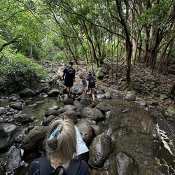

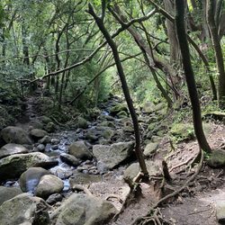


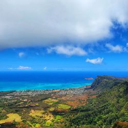


Why does Yelp recommend reviews?
4 reviews that are not currently recommended
The reviews below are not factored into the business's overall star rating.
10 years ago
9 years ago
10 years ago
10 years ago
Moanalua Middle Ridge - hiking - Updated July 2026
Best of Honolulu
People found Moanalua Middle Ridge by searching for…
Trending Searches in Honolulu, HI
Blueberry Picking near Moanalua Middle Ridge
Boating near Moanalua Middle Ridge
Cliff Jumping near Moanalua Middle Ridge
Cruising Spots near Moanalua Middle Ridge
Day Trips near Moanalua Middle Ridge
Dog Friendly Things To Do near Moanalua Middle Ridge
Flower Fields near Moanalua Middle Ridge
Indoor Mini Golf near Moanalua Middle Ridge
Jet Skis near Moanalua Middle Ridge
Kayak Rental near Moanalua Middle Ridge
Kids Activities Indoor near Moanalua Middle Ridge
Lakes near Moanalua Middle Ridge
Lookout Points near Moanalua Middle Ridge
Outdoor Activities near Moanalua Middle Ridge
Parks near Moanalua Middle Ridge
River Swimming near Moanalua Middle Ridge
Rock Quarry near Moanalua Middle Ridge
Scenic Overlook near Moanalua Middle Ridge
Sunrise View near Moanalua Middle Ridge
Surf Shop near Moanalua Middle Ridge
Swimming Holes near Moanalua Middle Ridge
Things To Do On A Rainy Day near Moanalua Middle Ridge
U Pick Farms near Moanalua Middle Ridge
Watch Sunset near Moanalua Middle Ridge
Browse Articles
Browse Nearby
BEST of Honolulu, Hawaii Coffee near Moanalua Middle Ridge
BEST of Honolulu, Hawaii Things to Do near Moanalua Middle Ridge
BEST of Honolulu, Hawaii Restaurants near Moanalua Middle Ridge
BEST of Honolulu, Hawaii Scenic View near Moanalua Middle Ridge
BEST of Honolulu, Hawaii Breakfast near Moanalua Middle Ridge
BEST of Honolulu, Hawaii Parks near Moanalua Middle Ridge
BEST of Honolulu, Hawaii Campgrounds near Moanalua Middle Ridge
Browse Brands
Related Searches in Honolulu, HI
Best Dog Hiking Trails Around Honolulu, Hawaii
Best Fishing Locations and Guides in Honolulu, Hawaii
Best Nature Trails for Hiking in Honolulu, Hawaii
Best Places for Horseback Riding in Honolulu, Hawaii
Best Sightseeing Experiences Available in Honolulu, Hawaii
Best Waterfalls and Swimming Holes in Honolulu, Hawaii
Discover Dog Friendly Trails to Explore in Honolulu, Hawaii
Discover Easy Hiking Trails Near Honolulu, Hawaii
Discover Kid Friendly Hiking Trails in Honolulu, Hawaii
Discover Popular Bike Trails in Honolulu, Hawaii
Discover Scenic Mountain Bike Trails Near Honolulu, Hawaii
Discover Top Nature Parks to Visit in Honolulu, Hawaii
Discover Walking Parks in Honolulu, Hawaii Near You
Discover a Hiking Trail in Honolulu, Hawaii
Discover the Best Night Hike Trails in Honolulu, Hawaii
Dog-Friendly Hikes With Dogs in Honolulu, Hawaii
Enjoy Camping Adventures Around Honolulu, Hawaii
Enjoy Kayaking Adventures in Honolulu, Hawaii
Enjoy Off Leash Dog Hikes in Honolulu, Hawaii
Enjoy Tent Camping Spots Around Honolulu, Hawaii
Enjoy a Beautiful Waterfall Hike in Honolulu, Hawaii
Enjoy the Best Walking Path in Honolulu, Hawaii
Enjoy the Best Walking Trails in Honolulu, Hawaii
Explore Easy Hikes Perfect for All in Honolulu, Hawaii
Explore Fun Activities to Do in Honolulu, Hawaii
Explore Popular Campgrounds Near Honolulu, Hawaii
Explore Popular State Park Destinations in Honolulu, Hawaii
Explore Top Dog Parks in Honolulu, Hawaii Near You
Explore the Best Beach Spots in Honolulu, Hawaii
Family Friendly Hiking With Kids in Honolulu, Hawaii
Find Cozy Camping Cabins in Honolulu, Hawaii
Find Popular Ziplining Spots Around Honolulu, Hawaii
Find Top Dog Friendly Parks to Visit in Honolulu, Hawaii
Find Top-Rated Waterfalls in Honolulu, Hawaii Now
Find the Best Parks for Picnics in Honolulu, Hawaii
Hiking Trails With Waterfalls in Honolulu, Hawaii
Off Leash Dog Hiking Trails in Honolulu, Hawaii
Picnic Areas With BBQ Pits Available in Honolulu, Hawaii
Popular Outdoor Activities to Try in Honolulu, Hawaii
Popular Picnic Spots to Visit in Honolulu, Hawaii
Popular Waterfall Hiking Trails in Honolulu, Hawaii
Safe and Fun Parks for Kids in Honolulu, Hawaii
Top Hiking Trails to Explore in Honolulu, Hawaii
Top Playgrounds for Kids to Enjoy in Honolulu, Hawaii
Top Running Trails to Explore in Honolulu, Hawaii
Top Swimming Spots and Pools in Honolulu, Hawaii
Top Things to Do With Kids in Honolulu, Hawaii
Top-Rated Camping Sites in Honolulu, Hawaii