Timber Creek Overlook Trail Photos

You might also consider
More like Timber Creek Overlook Trail
Recommended Reviews - Timber Creek Overlook Trail
Start your review...

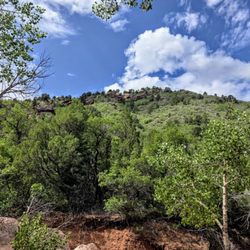
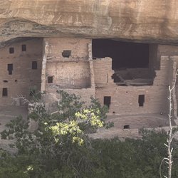
It's short, but it's a real trail, not paved, with uneven areas and rocks, and it's mostly exposed. The end gives you a more 270 or so view than the overlook from the parking lot. At all of the stops along the road in the park there are pit toilets and no water, so fill bottles for drinking at the visitor center at the bottom. read more


More info about Timber Creek Overlook Trail
New Harmony, UT 84757
Directions
Hours
Outdoor Amenities


Timber Creek Overlook Trail - hiking - Updated May 2026
Best of New Harmony
People found Timber Creek Overlook Trail by searching for…
Things to Do in New Harmony, Utah
Scenic Overlook in New Harmony, Utah
Visitor Centers in New Harmony, Utah
Hiking Trails in New Harmony, Utah
Lookout Points in New Harmony, Utah
Beautiful Views in New Harmony, Utah
Easy Hikes in New Harmony, Utah
Waterfalls in New Harmony, Utah
Dog Walking Areas in New Harmony, Utah
Walking Trails in New Harmony, Utah
Fitness & Instruction in New Harmony, Utah
Off Road Trails in New Harmony, Utah
Hikes With Dogs in New Harmony, Utah
Scenic Night View in New Harmony, Utah
Bike Paths in New Harmony, Utah
Browse Articles
Browse Nearby
Browse Brands
Related Searches in New Harmony, UT
Best Fishing Locations and Guides in New Harmony, Utah
Best Places for Horseback Riding in New Harmony, Utah
Enjoy Exciting Mountain Biking Adventures in New Harmony, Utah
Explore Beautiful Parks and Green Spaces in New Harmony, Utah
Explore Bike Rentals Throughout New Harmony, Utah
Explore Popular Campgrounds Near New Harmony, Utah
Hiking Trails With Waterfalls in New Harmony, Utah
Plan a Scenic Drive Route Near New Harmony, Utah
Trending Searches in New Harmony, UT
Bounce House Rentals near Timber Creek Overlook Trail
Campgrounds near Timber Creek Overlook Trail
Cliff Jumping near Timber Creek Overlook Trail
Flower Shop near Timber Creek Overlook Trail
Nurseries & Gardening near Timber Creek Overlook Trail
Outdoor Furniture Stores near Timber Creek Overlook Trail
Parks near Timber Creek Overlook Trail
Party Equipment Rentals near Timber Creek Overlook Trail
Pedicure near Timber Creek Overlook Trail
Photo Spots near Timber Creek Overlook Trail
Picnic Areas near Timber Creek Overlook Trail
Places To Take Pictures near Timber Creek Overlook Trail
Running Trails near Timber Creek Overlook Trail
Rv Rental near Timber Creek Overlook Trail
Scenic Drive near Timber Creek Overlook Trail
Sunrise View near Timber Creek Overlook Trail
Swimming Holes near Timber Creek Overlook Trail