Stowe Recreation Path Photos


More like Stowe Recreation Path
Recommended Reviews - Stowe Recreation Path
Start your review...

Reviews With Photos
")


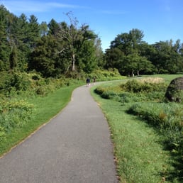
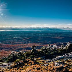
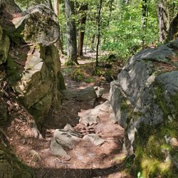
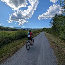
This 5.3 mile paved recreation path runs along and crisscrosses the West Branch of Little River from Stowe Village to the Topnotch Resort. The path starts in a gravel parking lot behind Village Hall and the Community Church in the village. The smooth, mostly flat blacktop surface is popular with walkers, runners, bikers, and rollerbladers in warmer weather and with snow shoe trekkers and cross country skiers when snow permits. The path is very easy and offers picturesque views of the nearby mountains as well as access to restaurants and other shops. There are parking lots along the path, so you can split up the experience into smaller pieces or do all 10.6 miles at once. Many of the markers denoting the mileage have faded or been painted over, so it's easy to lose track of your progress; the covered bridge described as being at the west end of the trail is actually a few hundred feet past the end of the trail. Pro Tip: There are bike maintenance stations at Lintilhac Park and Chase Park that provide riders with tools necessary to perform basic bike repairs and maintenance -- inflating a flat tire or adjusting brakes and derailleurs.

STUNNING! Early October brought us a New England fall dream. Plenty of colors, fields, a river, farms.... it was awesome! Plenty of space for bike riders and walkers. I highly recommend renting a bike or bringing your bike. It was so fun! Spots to pull off the path and relax or to take the sights in. Wear your mask. Some areas of the path busier than others. Will definitely ride or walk the path again. Plenty of parking throughout the path along with some restaurants to stop by! Loved my time exploring!

Loved this path! It runs five miles throughout some of Stowe. We parked closest to the Mount Mansfield side of town and walked 3.75 miles before turning around. It was too hot once we got to a part of the path that was in the sun for awhile. But there were some beautiful views along the way! The only thing we didn't enjoy was the dozens of bikers constantly going past us. This is definitely a path with more bikers than walkers. Constantly having to move over or look behind us for fear of getting hit was tiring.
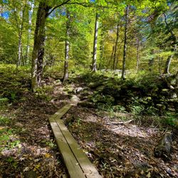
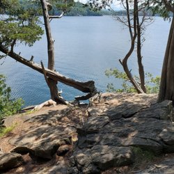
My husband and I walked a portion of the path on a recent Saturday morning. It was a little crowded and more narrow than we are used to, but every was very courteous and polite, which we are not used to. We crossed over three wooden bridges and had great views of the mountains and green fields. No complaints here. I walk on ride this again if I were in the area.

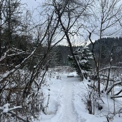
The path is snow covered right now but you don't happen to need snowshoes lately. It's a little like walking on stiff sand when the temperature is near 40 degrees, which it has been. Very few people have been on the path lately but we've had some clear, sunny days and walking on the rec path is a simple pleasure you shouldn't miss.

We lucked upon this path when visiting Stowe, what a beautiful walking trail. In late August, there were wildflowers in full bloom and phenomenal views of the mountains and streams. This is a great stop if you are eating your way across the area (Ben and Jerry's, Cabot, breweries, etc.) and feel like you need some exercise to counter it all. There are several parking areas and the one we were at behind the church also had a porta potty.

There is a farmers market right off the path on some Sundays so was a nice treat for us. It made the path nicer as we were able to get a little local taste and souvenirs! There are many places to eat right off path but make sure you rent a lock if you rented a bike and want to stop and eat. Best on a bike for visitors. My wife and I stopped at the farmers market and took pictures throughout so it took 1.5 hours out. It was only 30 min back because it's downhill if you start from downtown Stowe for your trip.

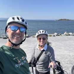
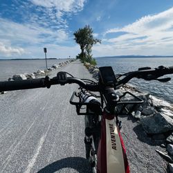
100% recommend this walking/bike path. Round trip, our bike ride was just about 10.5 miles. Along the way we passed a small memorial garden, athletic fields, an indoor public pool, restaurants, benches, a gazebo over looking the river and trash cans for your dog waste. At the other end, is a covered bridge just at the entrance to that parking area. There are several parking areas along the route with picnic tables and port-a-johns. Trails are kept in good conditiin. Lots of wooden brudges criss-cross the river. These are barely wide enough to pass pedestrians on a bike and most have an incline on both ends. This trail is in no way mostly flat. Our way out was an incline. Sometimes slight, sometimes more. The way back was *way* quicker and easier. Parking at this end is paved. Other lots along the way are a mix of dirt and paved. Signs trail side state to stop at road crossings and walk your bicycle across. Pedestrians and bicycles stay to the right. Let pedestrians, and other cyclists, know you are passing them. On-leash dog friendly. read more


The best hike of our whole trip to Vermont! Hardly took any photos because I was so in-the-peace of it all. Heavenly walk through the backside of Stowe, a paved nature path through meadows and woods and fields. So picturesque on even what started as a cold, rainy morning that became sunny and bright. A highlight of our trip and a good 4 miles (walked 2 miles each way). Can't wait to walk this again one day. 5 stars!!!! read more


1 year ago
1 year ago
7 months ago
Lovely scenic path for cycling and walking in the town of Stowe. Relatively flat most of the five miles in and out. Enjoy the verdant scenery of summer, the fluffy snow of winter, the fragrance of spring or the bright foliage of autumn! read more
 - Hiking Near Me")
 - Hiking Near Me")
 - Hiking Near Me")
 - Hiking Near Me")
 - Hiking Near Me")
 - Hiking Near Me")


9 months ago
3 years ago
We'd love to bike the path again someday when it is less busy. But even when shared with so many people, it's a beautiful trail. Stops to take a dip in the stream, breweries for a pint mid-cruise, and beautiful scenery. read more


This 5.3 mile paved recreation path runs along and crisscrosses the West Branch of Little River from Stowe Village to the Topnotch Resort. The path starts in a gravel parking lot behind Village Hall and the Community Church in the village. The smooth, mostly flat blacktop surface is popular with walkers, runners, bikers, and rollerbladers in warmer weather and with snow shoe trekkers and cross country skiers when snow permits. The path is very easy and offers picturesque views of the nearby mountains as well as access to restaurants and other shops. There are parking lots along the path, so you can split up the experience into smaller pieces or do all 10.6 miles at once. Many of the markers denoting the mileage have faded or been painted over, so it's easy to lose track of your progress; the covered bridge described as being at the west end of the trail is actually a few hundred feet past the end of the trail. Pro Tip: There are bike maintenance stations at Lintilhac Park and Chase Park that provide riders with tools necessary to perform basic bike repairs and maintenance -- inflating a flat tire or adjusting brakes and derailleurs. read more


STUNNING! Early October brought us a New England fall dream. Plenty of colors, fields, a river, farms.... it was awesome! Plenty of space for bike riders and walkers. I highly recommend renting a bike or bringing your bike. It was so fun! Spots to pull off the path and relax or to take the sights in. Wear your mask. Some areas of the path busier than others. Will definitely ride or walk the path again. Plenty of parking throughout the path along with some restaurants to stop by! Loved my time exploring! read more

7 years ago
Loved this path! It runs five miles throughout some of Stowe. We parked closest to the Mount Mansfield side of town and walked 3.75 miles before turning around. It was too hot once we got to a part of the path that was in the sun for awhile. But there were some beautiful views along the way! The only thing we didn't enjoy was the dozens of bikers constantly going past us. This is definitely a path with more bikers than walkers. Constantly having to move over or look behind us for fear of getting hit was tiring. read more


My husband and I walked a portion of the path on a recent Saturday morning. It was a little crowded and more narrow than we are used to, but every was very courteous and polite, which we are not used to. We crossed over three wooden bridges and had great views of the mountains and green fields. No complaints here. I walk on ride this again if I were in the area. read more

13 years ago
The path is snow covered right now but you don't happen to need snowshoes lately. It's a little like walking on stiff sand when the temperature is near 40 degrees, which it has been. Very few people have been on the path lately but we've had some clear, sunny days and walking on the rec path is a simple pleasure you shouldn't miss. read more


13 years ago
12 years ago
11 years ago
We lucked upon this path when visiting Stowe, what a beautiful walking trail. In late August, there were wildflowers in full bloom and phenomenal views of the mountains and streams. This is a great stop if you are eating your way across the area (Ben and Jerry's, Cabot, breweries, etc.) and feel like you need some exercise to counter it all. There are several parking areas and the one we were at behind the church also had a porta potty. read more

15 years ago
10 years ago
There is a farmers market right off the path on some Sundays so was a nice treat for us. It made the path nicer as we were able to get a little local taste and souvenirs! There are many places to eat right off path but make sure you rent a lock if you rented a bike and want to stop and eat. Best on a bike for visitors. My wife and I stopped at the farmers market and took pictures throughout so it took 1.5 hours out. It was only 30 min back because it's downhill if you start from downtown Stowe for your trip. read more


15 years ago
Great path in and around the Stowe area. Very slick on the bridges in the rain. There are some good places to stop and relax with food and drinks, great views and lots of friendly people. read more


12 years ago
13 years ago
9 years ago
16 years ago
More info about Stowe Recreation Path
Stowe, VT 05672
Directions
(802) 253-7321
Call Now
Hours
Outdoor Amenities
Ask the Community - Stowe Recreation Path
Review Highlights - Stowe Recreation Path


Stowe Recreation Path - hiking - Updated July 2026
Best of Stowe
People found Stowe Recreation Path by searching for…
Swimming Holes in Stowe, Vermont
Things to Do in Stowe, Vermont
Beautiful Views in Stowe, Vermont
Hiking Trails in Stowe, Vermont
Walking Trails in Stowe, Vermont
Places to Take Pictures in Stowe, Vermont
River Swimming in Stowe, Vermont
Parks for Kids in Stowe, Vermont
Off Road Trails in Stowe, Vermont
Running Trails in Stowe, Vermont
Mountain Biking in Stowe, Vermont
Off Leash Dog Hikes in Stowe, Vermont
Picnic Tables in Stowe, Vermont
Scenic Spots in Stowe, Vermont
Places to Go in Stowe, Vermont
Trending Searches in Stowe, VT
Boat Rental near Stowe Recreation Path
Cliff Jumping near Stowe Recreation Path
Day Trips near Stowe Recreation Path
Fireworks near Stowe Recreation Path
Kayak Rental near Stowe Recreation Path
Lakes & Ponds near Stowe Recreation Path
Off Road Trails near Stowe Recreation Path
Outdoor Activities near Stowe Recreation Path
Public Pools near Stowe Recreation Path
Public Shower near Stowe Recreation Path
River Swimming near Stowe Recreation Path
River Tubing near Stowe Recreation Path
Scenic Overlook near Stowe Recreation Path
Soccer Store near Stowe Recreation Path
Splash Pad near Stowe Recreation Path
Strawberry Picking near Stowe Recreation Path
Sunrise View near Stowe Recreation Path
Swimming Holes near Stowe Recreation Path
Swimming Lakes near Stowe Recreation Path
U Pick Farms near Stowe Recreation Path
Watch Sunset near Stowe Recreation Path
Browse Articles
Browse Nearby
BEST of Stowe, Vermont Restaurants near Stowe Recreation Path
BEST of Stowe, Vermont Coffee near Stowe Recreation Path
BEST of Stowe, Vermont Breakfast near Stowe Recreation Path
BEST of Stowe, Vermont Things to Do near Stowe Recreation Path
BEST of Stowe, Vermont Museums near Stowe Recreation Path
BEST of Stowe, Vermont Horseback Riding near Stowe Recreation Path
BEST of Stowe, Vermont Snow Tubing near Stowe Recreation Path
BEST of Stowe, Vermont Campgrounds near Stowe Recreation Path
BEST of Stowe, Vermont Ski Resorts near Stowe Recreation Path
Browse Brands
Related Searches in Stowe, VT
Affordable Kayak Rental Services in Stowe, Vermont
Best Fishing Locations and Guides in Stowe, Vermont
Best Places for Horseback Riding in Stowe, Vermont
Best Sledding Spots and Fun in Stowe, Vermont
Best Waterfalls and Swimming Holes in Stowe, Vermont
Check Out Off Road Trails in Stowe, Vermont
Discover Dog Friendly Trails to Explore in Stowe, Vermont
Discover Kid Friendly Hiking Trails in Stowe, Vermont
Discover Scenic Waterfall Spots in Stowe, Vermont
Discover Top Boat Tours in Stowe, Vermont for All Ages
Discover a Hiking Trail in Stowe, Vermont
Discover the Best Night Hike Trails in Stowe, Vermont
Dog-Friendly Hikes With Dogs in Stowe, Vermont
Enjoy Camping Adventures Around Stowe, Vermont
Enjoy Exciting Mountain Biking Adventures in Stowe, Vermont
Enjoy Kayaking Adventures in Stowe, Vermont
Enjoy River Tubing Adventures in Stowe, Vermont
Enjoy Tent Camping Spots Around Stowe, Vermont
Enjoy a Beautiful Waterfall Hike in Stowe, Vermont
Enjoy the Best Family Activities in Stowe, Vermont
Enjoy the Best Tubing Experiences in Stowe, Vermont
Enjoy the Best Walking Trails in Stowe, Vermont
Exciting Cliff Jumping Spots in Stowe, Vermont
Experience Thrilling White Water Rafting in Stowe, Vermont
Explore Beautiful Parks and Green Spaces in Stowe, Vermont
Explore Bike Rentals Throughout Stowe, Vermont
Explore Easy Hikes Perfect for All in Stowe, Vermont
Explore Fun Activities to Do in Stowe, Vermont
Explore Popular Campgrounds Near Stowe, Vermont
Explore Scenic Lakes to Visit in Stowe, Vermont
Explore Top Dog Parks in Stowe, Vermont Near You
Explore the Best Beach Spots in Stowe, Vermont
Explore the Best Boating Spots in Stowe, Vermont
Explore the Best Swimming Holes Around Stowe, Vermont
Find Beautiful Views in Stowe, Vermont
Find Cozy Camping Cabins in Stowe, Vermont
Find the Best Parks for Picnics in Stowe, Vermont
Find the Best Scenic View Locations in Stowe, Vermont
Hiking Trails With Waterfalls in Stowe, Vermont
Perfect Spots to Watch Sunset in Stowe, Vermont
Plan a Scenic Drive Route Near Stowe, Vermont
Popular Fishing Spots to Explore in Stowe, Vermont
Popular Outdoor Activities to Try in Stowe, Vermont
Popular Picnic Spots to Visit in Stowe, Vermont
Popular Things to Do in Stowe, Vermont
Safe and Fun Parks for Kids in Stowe, Vermont
Top Climbing Spots and Gyms in Stowe, Vermont
Top Paddleboarding Activities in Stowe, Vermont