Moss Glen Falls Photos


More like Moss Glen Falls
Recommended Reviews - Moss Glen Falls
Start your review...

Reviews With Photos


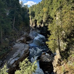
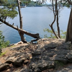
I love hiking and waterfalls and Moss Glen Falls is one of my favorite places in Vermont. I have been at least three times and every time, I enjoy sitting on rocks for a while and watch the waterfall ... so relaxing and peaceful. The hike to the waterfall is short and scenic and it is only about a 5-minute drive from Stowe's historic Village. The highlight of this hike is the actual Moss Glen Falls, which is only about a quarter-mile from the trail head. The trail signage is limited, but the trail is quite obvious by following the brook upstream to the falls from the parking area. The trail comes to a fork and hikers can either go left up the steeper rooty climb to the perfect location to take some photos of the falls, or to the right to follow the outer edge of the river to the base of the falls. Be careful at the falls--loose debris at the edge of the trail can be slippery and dangerous. Moss Glen Falls is the tallest waterfall in Vermont, cascading 85 feet!

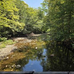
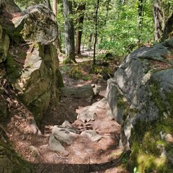
We visited our family quarantining and later on, touring Vermont right at the end of the leaf peeping season. Our last day, we wanted an easy hike before we set off back to New Hampshire. And we decided on Moss Glen Falls. Without a doubt one of the most visible and picturesque places to admire the work of some of nature's most assiduous engineers, the beavers. There were beaver paths everywhere, with felled trees that had likely been cut only a day or two before. This was an incredibly active beaver ecosystem. There were also numerous dams and tree transport paths, sort of beaver logging roads, leading to the several dams in the area. The path leading to the Falls through the beaver territory is undoubtedly, one of the best maintained walking trails I've seen. And par for Vermont, the numerous walkers exercised the outmost care in social distancing and mask wear. Then we came up to the falls area. Delightful. A fairly steep climb greeted us for different angles of viewing and picture taking. We visited the falls after several days of rains, and we were treated to a roaring sound and a beautiful series of cascades. We decided to turn back at the high points as our travel time was getting close, but we gained a beautiful memory of a delightful place.


Visited Moss Glen Falls on Sunday morning. A fairly easy short hike to see a pretty waterfall from several different angles. Definitely worth a quick visit when in Stowe. Quality: Moss Glen Falls is a beautiful waterfall on a very short trail. There are two trails to traverse in order to see the falls. One has you follow a rocky path through the small waterway to get a view from the bottom. The other has you climb a small hill to see the falls from above, but at a distance. Both are simple trails, but will likely get you a little wet and muddy. The waterfall is a nice payoff for such a brief hike. Quantity: There is a trail that goes beyond the waterfall, but it was closed off during out visit. It was less than a mile hike in and out. Value: No cost to park or hike this trail. Ambiance: Moss Glen Falls is a nice trail to a waterfall not far from Stowe, Vermont. The trail is very short, though there appeared to be a longer trail that went further. The waterfall itself is fairly small, but quite beautiful as it winds down the mountain. It was easy to get close to the falls, but the rocks nearby were very slippery and it seemed dangerous to climb further. This hike is nice way to enjoy the natural beauty of Vermont without being too strenuous. Crowd: It is a short trail with a nice waterfall close to Stowe, as such it gets a fair amount of guests. However, most only stay for a short visit. Service: Not a very large trail, but well maintained. Parking: Small dirt parking lot at the entrance, but large enough for all visitors during our visit to find spots.

We found ourselves with a little time to kill, and had seen many folks starting hikes near our hotel. Not having any gear, and having about an hour before another engagement, we consulted with the hotel concierge, who offered us a "Hiking Guide - Easy". I mean, we didn't say we wanted easy, but yeah, look at us. Inside the brochure were four nearby falls, with one attracting our attention as being billed as "one of the largest drops in the state". Anyway, for a great view with just a short hike, Moss Glen Falls certainly fits the bill. Easy to navigate to, and on this drizzly afternoon, we were the only ones at the parking/trailhead at first (a couple with a dog joined us later). But the parking area is not large, so maybe at certain times it might get full. The lower part of the trail is flatter and runs along the creek below the falls. Because of the day's drizzle, things were a bit muddy. Parts of the upper climb can get a little tricky if you're like us, just in sneakers and whatnot, if it's wet (or snowy). Look for tree-trunks and roots to push/pull your way up (and down) safely. Good views of the surrounding scenery along the way as well. You don't really see the entire 125 feet, as it's a series of small falls/cascades, most not on the usual hiking path, just the last 20-odd feet. But for us, it was a very peaceful (and fast) connection to nature.

Had this on our list to explore. So glad we did because although it was our first hike we managed to get it done. Must say it was a challenge coming down. The views are breathtaking so make sure to bring a camera. There are many paths, but don't worry about getting lost because there are plenty of other people enjoying the trails.

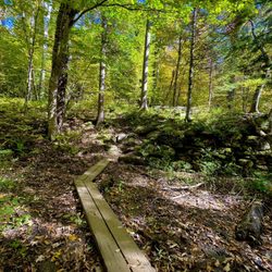
Moss Glenn Fall (near Stowe-there's something with a similar name an hour south) is a beautiful stream that cascades over a large granite face and is worth a visit. We made the short hike (which is well marked and not too difficult) on a sunny fall Monday and were pleased to have the place mostly to ourselves. Parking is a bit limited and you will just park along the edge of the dirt road. The hike itself is fairly straightforward. You start by following a dirt path and cross over some pretty wet spots on some narrow wooden walkways (watch your step!) but it quickly opens up to a fairly even walk through the woods although there are lots of tree roots. As you near the falls, it gets a bit rocky and steep but not a problem if you have on sturdy honking shoes. There are two routes-the "money shot" of the Falls is up so do that first then come back down and go along the river for so other nice views. The entire visit for us was maybe30-45 minutes-it's not very far to the falls. Definitely worth a visit.

You park right at the trail entrance. It's about a 10 minute walk to see the falls. We saw people swimming in them. You have the option of hiking up about 20 feet for a fabulous view of the falls or you can stay lower and see them too. It was muddy the day we walked the trail. This is about a 30 minute stop.


A 15-minute walk that's partially uphill toward the end once you reach the falls. Such crisp, cool, wet air as you approach the falls and a gorgeous view of how powerful they are. Quick, easy, and rewarding hike for any age. 5 stars!!! read more


Very short and enjoyable easy hike. It is boarded half way then up some steps to see this heavily flow waterfall. You can also go down to the lower fall with a bit of rock scramble. We did the hike in first week of June and it is very nice and easy. Our first attempt was back in mid April. The trail was still covered with snow. This time going back, the trail looks totally different and more enjoyable. My recommendation go in the month of June and till there is snow in Vermont. read more

11 months ago
My wife and I wanted to go on an outdoor adventure, so we set ourselves up for a nice hike to Moss Glen Falls. While we were originally expecting to do the full 5.2-mile trail, we were only able to complete a total of 0.6 miles due to trail closures. Most of the reviews for this spot focus on the falls themselves and honestly, if that's all you're here for, it's an easy 5 stars. The waterfall is stunning, powerful, and incredibly easy to access. On a Saturday afternoon, we saw plenty of people playing in the water and taking in the beauty. Fun fact: we learned it's the tallest waterfall in Vermont! This review, however, is for the VAST trail beyond the falls. At the top of the falls, you'll see a sign that says "End of Established Trail." If you go beyond it, you'll find yourself on a lightly maintained path that feels more like a walk through the woods than a scenic mountain trail. There are no real views to speak of, but the adventure comes from navigating the less-defined sections of the trail, stepping over fallen trees, and figuring out where the trail actually goes - definitely a "bring your inner Lewis & Clark" (or an AllTrails map) moment. The VAST trail has two ascents that give you a decent workout. It continues well past the end of the AllTrails map, but turning around at the second wooden bridge makes for a nice spot to stop and enjoy lunch. While we were a bit disappointed the longer route was closed, the beauty and accessibility of the waterfall made the trip worthwhile. Next time, we'll just plan to spend more time enjoying the falls themselves! read more
1 year ago
Located about 10 - 15 minutes outside of downtown Stowe and thought we would see the falls, A short and easy hike to the falls. There is lots of greenery, and a snake here or there. When you near the falls, it is a bit steep. The falls are not massive, but beautiful. read more


I love hiking and waterfalls and Moss Glen Falls is one of my favorite places in Vermont. I have been at least three times and every time, I enjoy sitting on rocks for a while and watch the waterfall ... so relaxing and peaceful. The hike to the waterfall is short and scenic and it is only about a 5-minute drive from Stowe's historic Village. The highlight of this hike is the actual Moss Glen Falls, which is only about a quarter-mile from the trail head. The trail signage is limited, but the trail is quite obvious by following the brook upstream to the falls from the parking area. The trail comes to a fork and hikers can either go left up the steeper rooty climb to the perfect location to take some photos of the falls, or to the right to follow the outer edge of the river to the base of the falls. Be careful at the falls--loose debris at the edge of the trail can be slippery and dangerous. Moss Glen Falls is the tallest waterfall in Vermont, cascading 85 feet! read more

We visited our family quarantining and later on, touring Vermont right at the end of the leaf peeping season. Our last day, we wanted an easy hike before we set off back to New Hampshire. And we decided on Moss Glen Falls. Without a doubt one of the most visible and picturesque places to admire the work of some of nature's most assiduous engineers, the beavers. There were beaver paths everywhere, with felled trees that had likely been cut only a day or two before. This was an incredibly active beaver ecosystem. There were also numerous dams and tree transport paths, sort of beaver logging roads, leading to the several dams in the area. The path leading to the Falls through the beaver territory is undoubtedly, one of the best maintained walking trails I've seen. And par for Vermont, the numerous walkers exercised the outmost care in social distancing and mask wear. Then we came up to the falls area. Delightful. A fairly steep climb greeted us for different angles of viewing and picture taking. We visited the falls after several days of rains, and we were treated to a roaring sound and a beautiful series of cascades. We decided to turn back at the high points as our travel time was getting close, but we gained a beautiful memory of a delightful place. read more


Visited Moss Glen Falls on Sunday morning. A fairly easy short hike to see a pretty waterfall from several different angles. Definitely worth a quick visit when in Stowe. Quality: Moss Glen Falls is a beautiful waterfall on a very short trail. There are two trails to traverse in order to see the falls. One has you follow a rocky path through the small waterway to get a view from the bottom. The other has you climb a small hill to see the falls from above, but at a distance. Both are simple trails, but will likely get you a little wet and muddy. The waterfall is a nice payoff for such a brief hike. Quantity: There is a trail that goes beyond the waterfall, but it was closed off during out visit. It was less than a mile hike in and out. Value: No cost to park or hike this trail. Ambiance: Moss Glen Falls is a nice trail to a waterfall not far from Stowe, Vermont. The trail is very short, though there appeared to be a longer trail that went further. The waterfall itself is fairly small, but quite beautiful as it winds down the mountain. It was easy to get close to the falls, but the rocks nearby were very slippery and it seemed dangerous to climb further. This hike is nice way to enjoy the natural beauty of Vermont without being too strenuous. Crowd: It is a short trail with a nice waterfall close to Stowe, as such it gets a fair amount of guests. However, most only stay for a short visit. Service: Not a very large trail, but well maintained. Parking: Small dirt parking lot at the entrance, but large enough for all visitors during our visit to find spots. read more


We found ourselves with a little time to kill, and had seen many folks starting hikes near our hotel. Not having any gear, and having about an hour before another engagement, we consulted with the hotel concierge, who offered us a "Hiking Guide - Easy". I mean, we didn't say we wanted easy, but yeah, look at us. Inside the brochure were four nearby falls, with one attracting our attention as being billed as "one of the largest drops in the state". Anyway, for a great view with just a short hike, Moss Glen Falls certainly fits the bill. Easy to navigate to, and on this drizzly afternoon, we were the only ones at the parking/trailhead at first (a couple with a dog joined us later). But the parking area is not large, so maybe at certain times it might get full. The lower part of the trail is flatter and runs along the creek below the falls. Because of the day's drizzle, things were a bit muddy. Parts of the upper climb can get a little tricky if you're like us, just in sneakers and whatnot, if it's wet (or snowy). Look for tree-trunks and roots to push/pull your way up (and down) safely. Good views of the surrounding scenery along the way as well. You don't really see the entire 125 feet, as it's a series of small falls/cascades, most not on the usual hiking path, just the last 20-odd feet. But for us, it was a very peaceful (and fast) connection to nature. read more


Had this on our list to explore. So glad we did because although it was our first hike we managed to get it done. Must say it was a challenge coming down. The views are breathtaking so make sure to bring a camera. There are many paths, but don't worry about getting lost because there are plenty of other people enjoying the trails. read more


Moss Glenn Fall (near Stowe-there's something with a similar name an hour south) is a beautiful stream that cascades over a large granite face and is worth a visit. We made the short hike (which is well marked and not too difficult) on a sunny fall Monday and were pleased to have the place mostly to ourselves. Parking is a bit limited and you will just park along the edge of the dirt road. The hike itself is fairly straightforward. You start by following a dirt path and cross over some pretty wet spots on some narrow wooden walkways (watch your step!) but it quickly opens up to a fairly even walk through the woods although there are lots of tree roots. As you near the falls, it gets a bit rocky and steep but not a problem if you have on sturdy honking shoes. There are two routes-the "money shot" of the Falls is up so do that first then come back down and go along the river for so other nice views. The entire visit for us was maybe30-45 minutes-it's not very far to the falls. Definitely worth a visit. read more


You park right at the trail entrance. It's about a 10 minute walk to see the falls. We saw people swimming in them. You have the option of hiking up about 20 feet for a fabulous view of the falls or you can stay lower and see them too. It was muddy the day we walked the trail. This is about a 30 minute stop. read more


5 years ago
Easy with kids (just steep at the end - be very careful). We walked 0.71 miles and were able to enjoy the view on top. The kids collected rocks too! read more


7 years ago
Mostly easy but for the view of the falls you do have to channel an inner mountain goat but go slow and it's easy. You can see the beavers hard work, one they have been working at awhile and one was freshly downed. So glad we went! read more


7 years ago
Short walking trial to get to the Moss Glen Falls. Great place to hike and cool off. Be careful trials are a bit narrow but the water is perfect for coping off on a hot summer day!!! read more


7 years ago
4 years ago
4 years ago
8 years ago
Uneven pieces of wood to walk across "swampy areas" but there is a muddy path to follow. The falls are beautiful. Lots of beaver dams along the way. The hike is doable. We hiked higher than the obvious fall to see if there was more. That part got a little steep especially in rainy -snowy weather:) read more


8 years ago
10 years ago
10 years ago
7 years ago
More info about Moss Glen Falls
369-615 Moss Glen Falls Rd
Stowe, VT 05672
Directions
Hours
Outdoor Amenities
Ask the Community - Moss Glen Falls
Review Highlights - Moss Glen Falls


Why does Yelp recommend reviews?
1 review that is not currently recommended
The reviews below are not factored into the business's overall star rating.
2 years ago
Moss Glen Falls - hiking - Updated July 2026
Best of Stowe
People found Moss Glen Falls by searching for…
Things to Do in Stowe, Vermont
Hiking Trails With Waterfalls in Stowe, Vermont
Walking Trails in Stowe, Vermont
Places to Take Pictures in Stowe, Vermont
Scenic Drive in Stowe, Vermont
Scenic Views in Stowe, Vermont
Scenic Overlook in Stowe, Vermont
Beautiful Views in Stowe, Vermont
Parks for Kids in Stowe, Vermont
Off Road Trails in Stowe, Vermont
Mountain Biking in Stowe, Vermont
Off Leash Dog Hikes in Stowe, Vermont
River Swimming in Stowe, Vermont
Fishing Spots in Stowe, Vermont
Trending Searches in Stowe, VT
Boat Rental near Moss Glen Falls
Cliff Jumping near Moss Glen Falls
Day Trips near Moss Glen Falls
Fireworks near Moss Glen Falls
Kayak Rental near Moss Glen Falls
Lakes & Ponds near Moss Glen Falls
Off Road Trails near Moss Glen Falls
Outdoor Activities near Moss Glen Falls
Public Pools near Moss Glen Falls
Public Shower near Moss Glen Falls
River Swimming near Moss Glen Falls
River Tubing near Moss Glen Falls
Scenic Overlook near Moss Glen Falls
Soccer Store near Moss Glen Falls
Splash Pad near Moss Glen Falls
Strawberry Picking near Moss Glen Falls
Sunrise View near Moss Glen Falls
Swimming Holes near Moss Glen Falls
Swimming Lakes near Moss Glen Falls
U Pick Farms near Moss Glen Falls
Watch Sunset near Moss Glen Falls
Browse Articles
Browse Nearby
Browse Brands
Related Searches in Stowe, VT
Affordable Kayak Rental Services in Stowe, Vermont
Best Fishing Locations and Guides in Stowe, Vermont
Best Places for Horseback Riding in Stowe, Vermont
Best Sledding Spots and Fun in Stowe, Vermont
Best Waterfalls and Swimming Holes in Stowe, Vermont
Check Out Off Road Trails in Stowe, Vermont
Discover Dog Friendly Trails to Explore in Stowe, Vermont
Discover Kid Friendly Hiking Trails in Stowe, Vermont
Discover Scenic Waterfall Spots in Stowe, Vermont
Discover Top Boat Tours in Stowe, Vermont for All Ages
Discover a Hiking Trail in Stowe, Vermont
Discover the Best Night Hike Trails in Stowe, Vermont
Dog-Friendly Hikes With Dogs in Stowe, Vermont
Enjoy Camping Adventures Around Stowe, Vermont
Enjoy Exciting Mountain Biking Adventures in Stowe, Vermont
Enjoy Kayaking Adventures in Stowe, Vermont
Enjoy River Tubing Adventures in Stowe, Vermont
Enjoy Tent Camping Spots Around Stowe, Vermont
Enjoy a Beautiful Waterfall Hike in Stowe, Vermont
Enjoy the Best Family Activities in Stowe, Vermont
Enjoy the Best Tubing Experiences in Stowe, Vermont
Enjoy the Best Walking Trails in Stowe, Vermont
Exciting Cliff Jumping Spots in Stowe, Vermont
Experience Thrilling White Water Rafting in Stowe, Vermont
Explore Beautiful Parks and Green Spaces in Stowe, Vermont
Explore Bike Rentals Throughout Stowe, Vermont
Explore Easy Hikes Perfect for All in Stowe, Vermont
Explore Fun Activities to Do in Stowe, Vermont
Explore Popular Campgrounds Near Stowe, Vermont
Explore Scenic Lakes to Visit in Stowe, Vermont
Explore Top Dog Parks in Stowe, Vermont Near You
Explore the Best Beach Spots in Stowe, Vermont
Explore the Best Boating Spots in Stowe, Vermont
Explore the Best Swimming Holes Around Stowe, Vermont
Find Beautiful Views in Stowe, Vermont
Find Cozy Camping Cabins in Stowe, Vermont
Find the Best Parks for Picnics in Stowe, Vermont
Find the Best Scenic View Locations in Stowe, Vermont
Hiking Trails With Waterfalls in Stowe, Vermont
Perfect Spots to Watch Sunset in Stowe, Vermont
Plan a Scenic Drive Route Near Stowe, Vermont
Popular Fishing Spots to Explore in Stowe, Vermont
Popular Outdoor Activities to Try in Stowe, Vermont
Popular Picnic Spots to Visit in Stowe, Vermont
Popular Things to Do in Stowe, Vermont
Safe and Fun Parks for Kids in Stowe, Vermont
Top Climbing Spots and Gyms in Stowe, Vermont
Top Paddleboarding Activities in Stowe, Vermont