Bingham Falls Photos
 - Hiking Near Me - Stowe, Vermont")


 - Hiking Near Me - Stowe, Vermont")
More like Bingham Falls
Recommended Reviews - Bingham Falls
Start your review...

Reviews With Photos

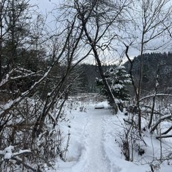
Admittedly, Bingham Falls isn't very large. But we couldn't think of a better place for a picnic, mid-summer swim, or photo session. Much like most of the best waterfalls in Vermont, Bingham can be accessed after a short, half-mile walk. It's an easy hike....0.5-mile out-and-back trail near Stowe, Vermont. Generally considered an easy route, it takes an average of 18 min to complete. Dogs are welcome, but must be on a leash.

What a gorgeous spot for an easy hike!!!! After runnning around Smugglers Notch, we wanted a nice hike to compliment the gorgeous day. So Bingham Falls was it. It's a nice hike in the woods in a very well maintained trail and then descending in almost a stairway made with rocks all the way to the wide area where the falls are. There are several spots where you can cross the river and admire the falls from different angles. The natural beauty was jaw dropping and on the other hand, the adherence to social distancing and mask wear by the many visitors was admirable. Returning to the parking lot, the climb up is a nice exercise, made worthy by the amazing scenery.

This place holds a special spot in my heart because it was the first ever nature-y adventure I've embarked on on vacation! I'm usually the one eating and drinking my way thru a trip and I'm thankful my boo pushed me out of my comfort zone for this one. TIP: this is kind of hard to find. When your GPS says you've arrived, and you see cars parked on the side of the road, well you have arrived my friend! Once you do find it, you walk about .5 of a mile to see these gorgeous falls. It's out of a movie for someone like me from Miami where we have nothing like this. Crystal clear water, birds chirping, beautiful rocks and falls. It's quite relaxing. Also amazing your cell service doesn't really work here because it lets you focus that much more. While I saw folks swim further down in the falls, we just relaxed on the rocks. I think we may have missed the actual falls, maybe we cut our hike short once we saw the first bit of beautiful water: either way, it was lovely and easy to move thru. Definitely make a stop here if you're in Stowe!


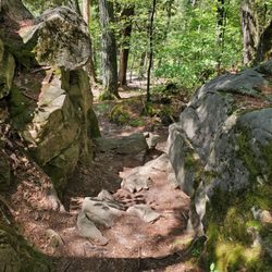
Bingham falls is one of those short hikes which you shouldn't miss if given the opportunity. The starting point of this fall starts from the parking lot which can be a little tricky. Let me explain. When you turn on the navigation for Bingham falls, it will end in the middle of road where you will see a bunch of cars parked on either side of the road. This is the parking lot for the fall. You haven't reached yet. Once you park, you'd be baffled with the lack of any sign or an entrance. Behind the parking lot, you can see in the woods a sign which would lead you to the falls. The fall itself is a few minutes away. The trail is steep down hill with slippery rocks and slopes. I'd recommend wearing a proper set of hiking boots for this trail. It isn't difficult so anyone could easily do this and watch the spectacular falls at the end of the trail. The parking area is limited but is available on either side of the road. I'd avoid this if there's rain pouring down since it'd make it more challenging to get a good grip going down the trail. The trail is decently maintained and there are sign boards to lead the way. A good trail overall and a must visit place if you're around the area

Bingham Falls is a little tricky to find as there isn't any sign by the road to mark the entrance to the trail. Our GPS led us right up to it and when you see a bunch of cars parked in the small lot on the left of the highway and maybe a few on the right, pull over, you have arrived, the entrance to the trail is a small opening in the tree on the opposite side as the larger parking area-there's an interpretive sign just inside so you know you are at the right spot. The first part of the trail is wide and easy and all down hill. As you approach the falls you will go down a staircase of boulders some of which may be wet and a little slippery so be sure to have hiking shoes and watch you step. The falls are nice but not that spectacular but worth the short hike. Remember it's all up hill coming back.

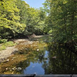
Hiked around Bingham Falls on Monday morning. A decent hike with a beautiful waterfall as the highlight. Quality: Mill Trail is short easy hike, with just one challenging stretch as you descend down to Bingham Falls. The trail starts with a few different paths to older buildings including remnants of an old blacksmith shop and a large cabin. The main trail is quite boring, and seems more like a mountain bike path than a hiking trail. However, the steep decline and incline to reach Bingham Falls is quite fun, and the actual waterfall is gorgeous. Quantity: We followed Mill Trail to Bingham Falls and then back out. With a few detours on the way it ended up being about two miles. Value: No cost to park or hike this trail. Ambiance: Bingham Falls is a set of trails and waterfall located very close to Stowe, Vermont. The two different trails that take you to the waterfall are relatively short and not too difficult to traverse. It is a forested area, along a hillside, so many small streams run down the mountain. This leaves it muddy and wet, so proper boots are recommended. The actual waterfall is awesome with pretty significant volume that crashes into a pool at the bottom. Even in the poor weather, some hikers decided to go for a swim. Crowd: There was one family swimming near the falls, but other than them, we only saw a few people while walking the trail. Service: The signage on the trail is horrendous. Multiple times we went the wrong direction and it could very easily be addressed. It is definitely a trail where it is best to follow your gut and the sounds of the main stream. Parking: There are at least two areas to park, both primarily street parking. We picked the less populated Mill Trail entrance.

What a gorgeous hike! The hiking trail is pretty clear and you hike a ways down before hitting the waterfall & river. As a beginner, I thought the hike was pretty easy and fun. A couple of important notes... The sign to Bingham falls is kinda tucked away in the woods so it can be easily missed. Drive towards smugglers notch state park and you will see two gravel parking lots on either side of the road. The sign will be on the right hand side if you are driving from Stowe. If you see the smugglers notch state park camper parking sign to your left, you drove too far. Don't wear your regular walking sandals! I saw so many people dressed like they were going to the mall while trying to get down to the falls...you know your in the woods, right?? The rocks get slippery and if you want to hop around the river/stream you won't be able to do that wearing flip flops.

Great spot to go on a hike, swim or just hangout and soak up the sun. Encountered no problems finding the parking lot (with the help of cellphone navigation!). We actually missed the falls the first time around, actually found one little waterfall with tall carved, cliff walls around the river. Just kept on walking up the trail, but found that the river was very calm and didn't seem right for a waterfall coming up soon. Before we turned around we found a nice, calm place that would have been ideal for swimming, given it wasn't the end of September! The water was about waist deep with icy, clear water. We eventually found the falls... then took the wrong way down, it seemed like a good idea at the time! From our vantage point we couldn't see the falls, after struggling back up to the trail and we were about to give up on getting close to the falls. I walked over to the edge and found a trail! When you come down off the main trail, go to the right towards the falls! Watch your step and use your hands for added balance, the rocks can be very slippery, I almost fell a few times. Make sure you have decent shoes to wear! Swimming here looks like it would be a ton of fun, plus there are lots of other pools to check out if the main one is too cold or crowded. Go exploring along the river and enjoy nature!

AMAZING stop on my roadtrip. Initially we drive right by this spot (lots of cars were parked but there were no signs) but then I read from another yelp review that if you pass the campground just ahead of this spot, you've gone too far. Thanks yelpers! We got caught in a rain storm, so we ran back to the car bc the tree canopy only held the massive downpour for so long. Once it passed, everyone was gone so we had the trail all alone. Quite slippery though so make sure you're wearing rubber bottom shoes or sneakers. Beautiful trail with a steep decline on the rocks, but well worth it as you can go down into the water and see the falls up close.


Have been going to Bingham Falls since the early 70's but havent been there in years so when we went on vacation we decided to stop there. It was just as i remember except for an improvement. They have added a fence along the walk down towards the falls. Great idea especially if you are hiking with kids. The stone stairs down to the falls can be a little slippery when they are wet but just take your time & it is fine. Great waterfall and swimming hole. So glad i went back to see it again.

We did a quick 15-min hike to the falls and got a somewhat-slippery though gorgeous view of the powerful falls and all the ways the water has shaped and smoothed the rocks. Loved the up-close view of it all and the shade of the forest. 5 stars!!!! read more


So glad we did the short but somewhat challenging hike to see these during our visit to Stowe - totally worth it. We parked at the trailhead (plenty of space on a weekday afternoon). Had to be careful on the rocks but on the whole doable. Wasn't brave enough to jump into the waters but you could. No restrooms that we saw so plan accordingly. read more


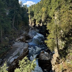
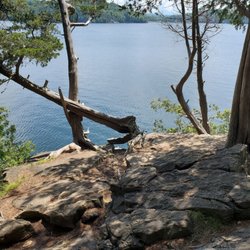
Bingham Falls is a spectacular waterfall! A must-see in Smuggler's Notch State Park for sure - the main falls is about 40 feet tall but it's surrounded by tons of other falls above and below - some small and tumbling, and some dramatic and crashing down! It's even more magnificent in the height of the fall foliage! There are two trails you can take to get to the falls. One side is only about 1/2 mile and 150 feet elevation gain - this is definitely the most popular bc it allows you to access the falls from very bottom and I saw tons of people on that side. But I wanted a longer, less busy trail so I opted to take the Mill Trail which puts you on the other side of the falls with no access to the bottom...you can only see it from above (the gorge walls are steep, slick and treacherous so there's no way down)...but the views from above are absolutely stunning! The water is so clear and is a deep bluish green color - very dramatic against the light gray rocks. And the gorge has lots of deep, cavernous pools that cause the waterfalls to be loud and booming - it's magnificent!! One of the most magical places I've seen - like something straight out of lord of the rings lol. AllTrails lists Mill Trail as easy with a total of 1.3 miles and about 150 feet elevation gain - but there are lots of trail offshoots and places to explore so I ended up doing just over 3 miles and about 300 feet elevation gain. The trail is very well maintained with several lovely bridges crossing smaller waterfalls. I do recommend downloading the map off AllTrails though bc there's no signal and the trail is hard to find closer to the falls. There's another path off to the left close to the trailhead that takes you down to the river with picnic tables and a historic saw mill building - it's a brilliant place to have a picnic or just relax by the gentle river - so lovely! There's also a historic cabin up on a big hill at the beginning of the trail that was built in the 1930s for the ski tourists - very fun to explore. There's some gravel pull offs at the trailhead for parking - and info signs and trail maps too - GPS takes you right to it. There aren't any bathrooms so plan ahead. The trail and falls are near the quaint town of Stowe which is a great place to relax and grab lunch after! read more


 - Hiking Near Me - Stowe, Vermont")
 - Hiking Near Me - Stowe, Vermont")
 - Hiking Near Me - Stowe, Vermont")

 - Hiking Near Me - Stowe, Vermont")


 - Hiking Near Me - Stowe, Vermont")
 - Hiking Near Me - Stowe, Vermont")
 - Hiking Near Me - Stowe, Vermont")

 - Hiking Near Me - Stowe, Vermont")

 - Hiking Near Me - Stowe, Vermont")
 - Hiking Near Me - Stowe, Vermont")

 - Hiking Near Me - Stowe, Vermont")
 - Hiking Near Me - Stowe, Vermont")
 - Hiking Near Me - Stowe, Vermont")
 - very well maintained - Hiking Near Me - Stowe, Vermont")

 - Hiking Near Me - Stowe, Vermont")
 - Hiking Near Me - Stowe, Vermont")


 - Hiking Near Me - Stowe, Vermont")


 - Hiking Near Me - Stowe, Vermont")
 - Hiking Near Me - Stowe, Vermont")
 - Hiking Near Me - Stowe, Vermont")


 - Hiking Near Me - Stowe, Vermont")
 - Hiking Near Me - Stowe, Vermont")
 - Hiking Near Me - Stowe, Vermont")
 - Hiking Near Me - Stowe, Vermont")


Admittedly, Bingham Falls isn't very large. But we couldn't think of a better place for a picnic, mid-summer swim, or photo session. Much like most of the best waterfalls in Vermont, Bingham can be accessed after a short, half-mile walk. It's an easy hike....0.5-mile out-and-back trail near Stowe, Vermont. Generally considered an easy route, it takes an average of 18 min to complete. Dogs are welcome, but must be on a leash. read more

11 months ago
What a gorgeous spot for an easy hike!!!! After runnning around Smugglers Notch, we wanted a nice hike to compliment the gorgeous day. So Bingham Falls was it. It's a nice hike in the woods in a very well maintained trail and then descending in almost a stairway made with rocks all the way to the wide area where the falls are. There are several spots where you can cross the river and admire the falls from different angles. The natural beauty was jaw dropping and on the other hand, the adherence to social distancing and mask wear by the many visitors was admirable. Returning to the parking lot, the climb up is a nice exercise, made worthy by the amazing scenery. read more


8 years ago
This place holds a special spot in my heart because it was the first ever nature-y adventure I've embarked on on vacation! I'm usually the one eating and drinking my way thru a trip and I'm thankful my boo pushed me out of my comfort zone for this one. TIP: this is kind of hard to find. When your GPS says you've arrived, and you see cars parked on the side of the road, well you have arrived my friend! Once you do find it, you walk about .5 of a mile to see these gorgeous falls. It's out of a movie for someone like me from Miami where we have nothing like this. Crystal clear water, birds chirping, beautiful rocks and falls. It's quite relaxing. Also amazing your cell service doesn't really work here because it lets you focus that much more. While I saw folks swim further down in the falls, we just relaxed on the rocks. I think we may have missed the actual falls, maybe we cut our hike short once we saw the first bit of beautiful water: either way, it was lovely and easy to move thru. Definitely make a stop here if you're in Stowe! read more


4 years ago
Such a pretty waterfall! Short hike to overlook area but if you want to get closer you have a rocky stair path you need to get down that can be slippery after rain. read more


Bingham falls is one of those short hikes which you shouldn't miss if given the opportunity. The starting point of this fall starts from the parking lot which can be a little tricky. Let me explain. When you turn on the navigation for Bingham falls, it will end in the middle of road where you will see a bunch of cars parked on either side of the road. This is the parking lot for the fall. You haven't reached yet. Once you park, you'd be baffled with the lack of any sign or an entrance. Behind the parking lot, you can see in the woods a sign which would lead you to the falls. The fall itself is a few minutes away. The trail is steep down hill with slippery rocks and slopes. I'd recommend wearing a proper set of hiking boots for this trail. It isn't difficult so anyone could easily do this and watch the spectacular falls at the end of the trail. The parking area is limited but is available on either side of the road. I'd avoid this if there's rain pouring down since it'd make it more challenging to get a good grip going down the trail. The trail is decently maintained and there are sign boards to lead the way. A good trail overall and a must visit place if you're around the area read more


2 years ago
Bingham Falls is a little tricky to find as there isn't any sign by the road to mark the entrance to the trail. Our GPS led us right up to it and when you see a bunch of cars parked in the small lot on the left of the highway and maybe a few on the right, pull over, you have arrived, the entrance to the trail is a small opening in the tree on the opposite side as the larger parking area-there's an interpretive sign just inside so you know you are at the right spot. The first part of the trail is wide and easy and all down hill. As you approach the falls you will go down a staircase of boulders some of which may be wet and a little slippery so be sure to have hiking shoes and watch you step. The falls are nice but not that spectacular but worth the short hike. Remember it's all up hill coming back. read more


 - Hiking Near Me - Stowe, Vermont")

Hiked around Bingham Falls on Monday morning. A decent hike with a beautiful waterfall as the highlight. Quality: Mill Trail is short easy hike, with just one challenging stretch as you descend down to Bingham Falls. The trail starts with a few different paths to older buildings including remnants of an old blacksmith shop and a large cabin. The main trail is quite boring, and seems more like a mountain bike path than a hiking trail. However, the steep decline and incline to reach Bingham Falls is quite fun, and the actual waterfall is gorgeous. Quantity: We followed Mill Trail to Bingham Falls and then back out. With a few detours on the way it ended up being about two miles. Value: No cost to park or hike this trail. Ambiance: Bingham Falls is a set of trails and waterfall located very close to Stowe, Vermont. The two different trails that take you to the waterfall are relatively short and not too difficult to traverse. It is a forested area, along a hillside, so many small streams run down the mountain. This leaves it muddy and wet, so proper boots are recommended. The actual waterfall is awesome with pretty significant volume that crashes into a pool at the bottom. Even in the poor weather, some hikers decided to go for a swim. Crowd: There was one family swimming near the falls, but other than them, we only saw a few people while walking the trail. Service: The signage on the trail is horrendous. Multiple times we went the wrong direction and it could very easily be addressed. It is definitely a trail where it is best to follow your gut and the sounds of the main stream. Parking: There are at least two areas to park, both primarily street parking. We picked the less populated Mill Trail entrance. read more


3 years ago
12 years ago
What a gorgeous hike! The hiking trail is pretty clear and you hike a ways down before hitting the waterfall & river. As a beginner, I thought the hike was pretty easy and fun. A couple of important notes... The sign to Bingham falls is kinda tucked away in the woods so it can be easily missed. Drive towards smugglers notch state park and you will see two gravel parking lots on either side of the road. The sign will be on the right hand side if you are driving from Stowe. If you see the smugglers notch state park camper parking sign to your left, you drove too far. Don't wear your regular walking sandals! I saw so many people dressed like they were going to the mall while trying to get down to the falls...you know your in the woods, right?? The rocks get slippery and if you want to hop around the river/stream you won't be able to do that wearing flip flops. read more


Great spot to go on a hike, swim or just hangout and soak up the sun. Encountered no problems finding the parking lot (with the help of cellphone navigation!). We actually missed the falls the first time around, actually found one little waterfall with tall carved, cliff walls around the river. Just kept on walking up the trail, but found that the river was very calm and didn't seem right for a waterfall coming up soon. Before we turned around we found a nice, calm place that would have been ideal for swimming, given it wasn't the end of September! The water was about waist deep with icy, clear water. We eventually found the falls... then took the wrong way down, it seemed like a good idea at the time! From our vantage point we couldn't see the falls, after struggling back up to the trail and we were about to give up on getting close to the falls. I walked over to the edge and found a trail! When you come down off the main trail, go to the right towards the falls! Watch your step and use your hands for added balance, the rocks can be very slippery, I almost fell a few times. Make sure you have decent shoes to wear! Swimming here looks like it would be a ton of fun, plus there are lots of other pools to check out if the main one is too cold or crowded. Go exploring along the river and enjoy nature! read more


AMAZING stop on my roadtrip. Initially we drive right by this spot (lots of cars were parked but there were no signs) but then I read from another yelp review that if you pass the campground just ahead of this spot, you've gone too far. Thanks yelpers! We got caught in a rain storm, so we ran back to the car bc the tree canopy only held the massive downpour for so long. Once it passed, everyone was gone so we had the trail all alone. Quite slippery though so make sure you're wearing rubber bottom shoes or sneakers. Beautiful trail with a steep decline on the rocks, but well worth it as you can go down into the water and see the falls up close. read more

12 years ago
This is was an amazing hike, we are beginners and it wasn't tough at all. We went all the way to the bottom of the falls near the water! We will definitely come back if we are in Vermont again. read more


8 years ago
Totally worth the hike - just beautiful. My photo doesn't do it justice. Swimming and fishing was great. read more


8 years ago
9 years ago
Have been going to Bingham Falls since the early 70's but havent been there in years so when we went on vacation we decided to stop there. It was just as i remember except for an improvement. They have added a fence along the walk down towards the falls. Great idea especially if you are hiking with kids. The stone stairs down to the falls can be a little slippery when they are wet but just take your time & it is fine. Great waterfall and swimming hole. So glad i went back to see it again. read more


9 years ago
What's not to love? it's a pretty easy hike from the parking area. The rocks can be a little slippery when it rains so take your time it's so nice to be next to a big waterfall the water was freezing in the middle of summer but like it still went swimming. The trail is definitely easy to follow ..don't worry about getting lost. I would definitely go if you have never been, it's really pretty... don't miss it if you're coming to Stowe even if you're not a hiking type of person. read more


11 years ago
13 years ago
14 years ago
8 years ago
We liked moss glen falls better but this was still fun. 25 min hike round trip. Steep rock steps towards the bottom of the falls. Going up them was like being on a stair master lol. Unable to see the falls unless you travel off the path into the woods or follow stone steps down. read more


8 years ago
6 years ago
11 years ago
12 years ago
13 years ago
More info about Bingham Falls
Rt 108
Stowe, VT 05672
Directions
Hours
Outdoor Amenities
Ask the Community - Bingham Falls
Review Highlights - Bingham Falls


Why does Yelp recommend reviews?
Bingham Falls - hiking - Updated June 2026
Best of Stowe
People found Bingham Falls by searching for…
Trending Searches in Stowe, VT
Amusement Parks near Bingham Falls
Boat Rental near Bingham Falls
Cliff Jumping near Bingham Falls
Fishing Spots near Bingham Falls
Outdoor Activities near Bingham Falls
Pick Your Own Farms near Bingham Falls
Public Pools near Bingham Falls
Public Shower near Bingham Falls
River Swimming near Bingham Falls
Scenic Drive near Bingham Falls
Soccer Store near Bingham Falls
Strawberry Picking near Bingham Falls
Swimming Holes near Bingham Falls
Swimming Lakes near Bingham Falls
Swimming Pools near Bingham Falls
Watch Sunset near Bingham Falls
Browse Articles
Browse Nearby
BEST of Stowe, Vermont Restaurants near Bingham Falls
BEST of Stowe, Vermont Coffee near Bingham Falls
BEST of Stowe, Vermont Things to Do near Bingham Falls
BEST of Stowe, Vermont Shopping near Bingham Falls
BEST of Stowe, Vermont Breakfast near Bingham Falls
Browse Brands
Related Searches in Stowe, VT
Affordable Kayak Rental Services in Stowe, Vermont
Best Fishing Locations and Guides in Stowe, Vermont
Best Places for Horseback Riding in Stowe, Vermont
Best Sledding Spots and Fun in Stowe, Vermont
Best Waterfalls and Swimming Holes in Stowe, Vermont
Check Out Off Road Trails in Stowe, Vermont
Discover Dog Friendly Trails to Explore in Stowe, Vermont
Discover Kid Friendly Hiking Trails in Stowe, Vermont
Discover Scenic Waterfall Spots in Stowe, Vermont
Discover Top Boat Tours in Stowe, Vermont for All Ages
Discover a Hiking Trail in Stowe, Vermont
Discover the Best Night Hike Trails in Stowe, Vermont
Dog-Friendly Hikes With Dogs in Stowe, Vermont
Enjoy Camping Adventures Around Stowe, Vermont
Enjoy Exciting Mountain Biking Adventures in Stowe, Vermont
Enjoy Kayaking Adventures in Stowe, Vermont
Enjoy River Tubing Adventures in Stowe, Vermont
Enjoy Tent Camping Spots Around Stowe, Vermont
Enjoy a Beautiful Waterfall Hike in Stowe, Vermont
Enjoy the Best Family Activities in Stowe, Vermont
Enjoy the Best Tubing Experiences in Stowe, Vermont
Enjoy the Best Walking Trails in Stowe, Vermont
Exciting Cliff Jumping Spots in Stowe, Vermont
Experience Thrilling White Water Rafting in Stowe, Vermont
Explore Beautiful Parks and Green Spaces in Stowe, Vermont
Explore Bike Rentals Throughout Stowe, Vermont
Explore Easy Hikes Perfect for All in Stowe, Vermont
Explore Fun Activities to Do in Stowe, Vermont
Explore Popular Campgrounds Near Stowe, Vermont
Explore Scenic Lakes to Visit in Stowe, Vermont
Explore Top Dog Parks in Stowe, Vermont Near You
Explore the Best Beach Spots in Stowe, Vermont
Explore the Best Boating Spots in Stowe, Vermont
Explore the Best Swimming Holes Around Stowe, Vermont
Find Beautiful Views in Stowe, Vermont
Find Cozy Camping Cabins in Stowe, Vermont
Find the Best Parks for Picnics in Stowe, Vermont
Find the Best Scenic View Locations in Stowe, Vermont
Hiking Trails With Waterfalls in Stowe, Vermont
Perfect Spots to Watch Sunset in Stowe, Vermont
Plan a Scenic Drive Route Near Stowe, Vermont
Popular Fishing Spots to Explore in Stowe, Vermont
Popular Outdoor Activities to Try in Stowe, Vermont
Popular Picnic Spots to Visit in Stowe, Vermont
Popular Things to Do in Stowe, Vermont
Safe and Fun Parks for Kids in Stowe, Vermont
Top Climbing Spots and Gyms in Stowe, Vermont
Top Paddleboarding Activities in Stowe, Vermont