Stowe Pinnacle Photos


 - Hiking Near Me - Stowe, Vermont")

More like Stowe Pinnacle
Recommended Reviews - Stowe Pinnacle
Start your review...

Reviews With Photos
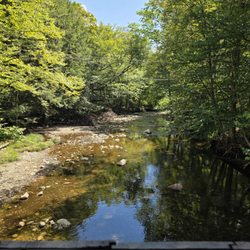
Fantastic view! We parked at the Pinnacle Meadows lot in order to avoid part of the more treacherous main trail. It was a moderate to difficult hike for us. We aren't experienced hikers, so that's the only reason why. It was mostly uphill. Definitely worth it! It took about an hour and a half each way.

Such an amazing hike! Me and my family do it every time we visit VT. It's moderate to challenging depending on your physical fitness and athletic capabilities. Takes around 2 hours. Great length. Definitely uphill most of the way to the top but SO worth it for the view. Incredible summit. It's also easy to navigate because it's an out and back and the trail is very well marked. There's also a second parking lot a bit higher up if you want to do a shorter version of this hike. read more


6 years ago
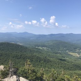
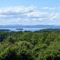
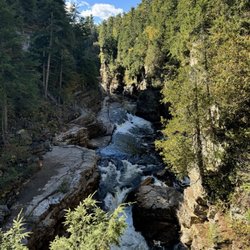
Stowe Pinnacle Trail is a quick hike but strenuous in some parts. Towards the top there is a serious incline which can be tricky if it rained/snowed recently. Took us around 2hrs round trip and the steep incline really got the blood pumping. If you reach the top you are rewarded with a 360 degree view of the surrounding area. I highly recommend! read more


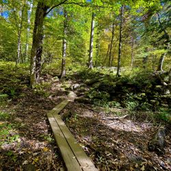
Hiked Stowe Pinnacle on Saturday morning. It is a nice, but challenging hike with a gorgeous view at the top, but the crowds and the relatively monotonous forest trail are downsides. Quality: Stowe Pinnacle is a steep and strenuous hike located close to the downtown Stowe area. From the start you are immediately headed upwards through the forested area, and it maintains this incline almost the entire way. Towards the top there is a little bit of rock scrambling, but nothing too difficult. There are no viewpoints until you reach the peak, which does provide beautiful views of the surrounding area. Going down is faster, but I found it significantly more challenging. Quantity: The hike is a little under 4 miles, but its steep incline makes it seem like more. Value: No fee to park or traverse this trail. Ambiance: Stowe Pinnacle is a trail located near Stowe, Vermont. It is a steep mountain climb, in and out, through a forested area and up to the 2,650 foot peak. The problem with the hike is that there is not much excitement until you reach the top. No viewpoints, minimal signage describing the area, and a lot of repetitive forest landscapes. Crowd: There were a lot of people hiking the trail, which is set up as in and out. It can be challenging, but there were plenty of children and dogs able to make it to the top. Service: A busy, but well-maintained trail. A few more distance markers would be helpful. Parking: Two small lots at the trailhead, but they fill up fast so expect to park on the side of the road. read more


7 years ago
Fantastic view! We parked at the Pinnacle Meadows lot in order to avoid part of the more treacherous main trail. It was a moderate to difficult hike for us. We aren't experienced hikers, so that's the only reason why. It was mostly uphill. Definitely worth it! It took about an hour and a half each way. read more


5 years ago
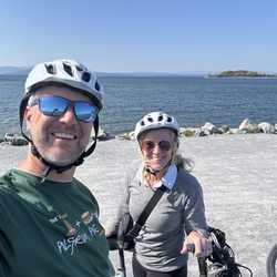
I loved hiking here!! The view was worth every step. Plus there's a local dog that hikes the trail every day! read more

7 years ago
13 years ago
9 years ago
More info about Stowe Pinnacle
663 Upper Hollow Rd
Stowe, VT 05672
Directions
Hours
Outdoor Amenities
Ask the Community - Stowe Pinnacle
Review Highlights - Stowe Pinnacle


Why does Yelp recommend reviews?
Stowe Pinnacle - hiking - Updated July 2026
Best of Stowe
People found Stowe Pinnacle by searching for…
Hiking Trails in Stowe, Vermont
Things to Do in Stowe, Vermont
Walking Trails in Stowe, Vermont
Scenic Overlook in Stowe, Vermont
Dog Swimming in Stowe, Vermont
Beautiful Views in Stowe, Vermont
Hikes With Dogs in Stowe, Vermont
Scenic Views in Stowe, Vermont
Dog Friendly Trails in Stowe, Vermont
Off Leash Dog Hikes in Stowe, Vermont
Running Trails in Stowe, Vermont
Picnic Areas in Stowe, Vermont
Hiking Trails Kid Friendly in Stowe, Vermont
Swimming Holes in Stowe, Vermont
Picnic Spots in Stowe, Vermont
Picnic Tables in Stowe, Vermont
Scenic Drive in Stowe, Vermont
Trending Searches in Stowe, VT
Boat Rental near Stowe Pinnacle
Cliff Jumping near Stowe Pinnacle
Dog Swimming near Stowe Pinnacle
Fishing Spots near Stowe Pinnacle
Kayak Rental near Stowe Pinnacle
Kids Activities Outdoor near Stowe Pinnacle
Lakes & Ponds near Stowe Pinnacle
Off Road Trails near Stowe Pinnacle
Outdoor Activities near Stowe Pinnacle
Picnic Areas near Stowe Pinnacle
Public Pools near Stowe Pinnacle
Public Shower near Stowe Pinnacle
River Swimming near Stowe Pinnacle
River Tubing near Stowe Pinnacle
Scenic Overlook near Stowe Pinnacle
Soccer Store near Stowe Pinnacle
Splash Pad near Stowe Pinnacle
Strawberry Picking near Stowe Pinnacle
Sunrise View near Stowe Pinnacle
Swimming Holes near Stowe Pinnacle
Swimming Lakes near Stowe Pinnacle
U Pick Farms near Stowe Pinnacle
Watch Sunset near Stowe Pinnacle
Browse Articles
Browse Nearby
BEST of Stowe, Vermont Coffee near Stowe Pinnacle
BEST of Stowe, Vermont Restaurants near Stowe Pinnacle
BEST of Stowe, Vermont Things to Do near Stowe Pinnacle
BEST of Stowe, Vermont Breakfast near Stowe Pinnacle
BEST of Stowe, Vermont Walking Trails near Stowe Pinnacle
BEST of Stowe, Vermont Parks near Stowe Pinnacle
BEST of Stowe, Vermont Caves near Stowe Pinnacle
Browse Brands
Related Searches in Stowe, VT
Affordable Kayak Rental Services in Stowe, Vermont
Best Fishing Locations and Guides in Stowe, Vermont
Best Places for Horseback Riding in Stowe, Vermont
Best Sledding Spots and Fun in Stowe, Vermont
Best Water Parks for Kids in Stowe, Vermont
Best Waterfalls and Swimming Holes in Stowe, Vermont
Check Out Great Playgrounds in Stowe, Vermont
Check Out Off Road Trails in Stowe, Vermont
Discover Dog Friendly Trails to Explore in Stowe, Vermont
Discover Free Parking Options in Stowe, Vermont
Discover Fun Activities to Do in Stowe, Vermont
Discover Kid Friendly Hiking Trails in Stowe, Vermont
Discover Popular Photo Spots in Stowe, Vermont
Discover Scenic Waterfall Spots in Stowe, Vermont
Discover Top Boat Tours in Stowe, Vermont for All Ages
Discover Top Nature Parks to Visit in Stowe, Vermont
Discover a Hiking Trail in Stowe, Vermont
Discover the Best Beaches in Stowe, Vermont
Discover the Best Night Hike Trails in Stowe, Vermont
Dog-Friendly Hikes With Dogs in Stowe, Vermont
Enjoy Camping Adventures Around Stowe, Vermont
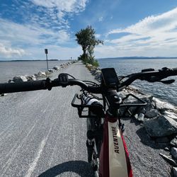
Enjoy Exciting Mountain Biking Adventures in Stowe, Vermont
Enjoy Kayaking Adventures in Stowe, Vermont
Enjoy River Tubing Adventures in Stowe, Vermont
Enjoy Tent Camping Spots Around Stowe, Vermont
Enjoy a Beautiful Waterfall Hike in Stowe, Vermont
Enjoy the Best Family Activities in Stowe, Vermont
Enjoy the Best Picnic Spots and Ideas in Stowe, Vermont
Enjoy the Best Tubing Experiences in Stowe, Vermont
Enjoy the Best Walking Trails in Stowe, Vermont
Exciting Cliff Jumping Spots in Stowe, Vermont
Experience Thrilling White Water Rafting in Stowe, Vermont
Explore Beautiful Parks and Green Spaces in Stowe, Vermont
Explore Bike Rentals Throughout Stowe, Vermont
Explore Easy Hikes Perfect for All in Stowe, Vermont
Explore Family-Friendly Zoos and Wildlife in Stowe, Vermont
Explore Free Picnic Areas Around Stowe, Vermont
Explore Free Things to Do Around Stowe, Vermont
Explore Fun Activities to Do in Stowe, Vermont
Explore Landmarks & Historical Buildings in Stowe, Vermont
Explore Popular Campgrounds Near Stowe, Vermont
Explore Popular Picnic Areas Around Stowe, Vermont
Explore Popular RV Parks Around Stowe, Vermont
Explore Popular Recreation Centers Around Stowe, Vermont
Explore Popular Scenic Views Near Stowe, Vermont
Explore Scenic Lakes to Visit in Stowe, Vermont
Explore Secret Spots Worth Visiting in Stowe, Vermont
Explore Top Dog Parks in Stowe, Vermont Near You