Mount Mansfield Photos


More like Mount Mansfield
Recommended Reviews - Mount Mansfield
Start your review...

Reviews With Photos

The weather was incredibly cold, and the wind was whipping. It was cloudy towards the summit so you were unable to see what you were getting yourself into. I will definitely start by saying I was in love with this hike. Something for everyone. However once you started getting worn down by the wind, and the clouds started to unveil what you were getting into there technically false summits in a sense. so you're coming up to the first one you think you're good then you climb on it to see there's another one then climb on that to see that there's another one. However, I will go back to my previous statement saying I really did the scrambles, the bridges, the little waterfalls, the Alpine trees. It just really was a great hike. Had it warmer and not foggy I would've loved it more. The entry fee is five dollars per person. I did want to note that. I do recommend this mountain. The views were absolutely incredible. especially in the fall.

We took the toll road up to parking lot A. I thought it was a bit pricy -- they should offer a military discount, but the drive up was a fun drive in our jeep! The pitch hit 13 degrees. The hike through the forest and to the top of the mountain is my all-time favorite hike in the world!! The smell of the trees was so powerful, it put a smile on my face with every step. The views were stunning! I could stay here for hours. What a beautiful hike! This was my favorite event on our 10 day vacation.


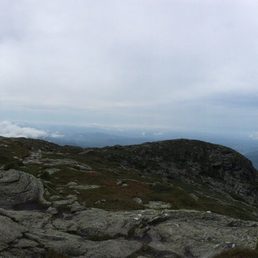
It was nice to see some fall colors. We hiked up through Maple Ridge Trail and hiked down through Sunset trail, total 7 miles on the trail, and additional 0.5 mile one way to the parking spot due to the busiest time of the year in October for foliage. This is the tallest mountain of Vermont and actually you can drive up near the summit. I don't like much about the idea to have a road in the mountain, because not nature respective people come. The day I hiked was cloudy near the top and short of view, but if it was sunny it would be nice view.

Mt. Mansfield Mt. Mansfield is not your typical everyday hike. This isn't for the faint of hearts. It requires mental strength over physical, demands courage and the urge to complete this trail no matter the weather conditions to conquer the summit. I planned to hike Mt. Mansfield with my friends during my fall foliage trip to Vermont. We took the auto toll road up to the visitors center which was $25 per vehicle with a driver and $9 for additional passengers. If you're planning to hike from the very bottom of the mountain, there are a couple of trails to watch out for. The visitors center was closed during our time of visit due to COVID but there was a helpful guide who was giving us information about the hike and guiding other travelers and hikers. There were a couple of hikes from that point. Let's talk about the hike itself. The hike was not ordinary. It had steep edges, rocks, 500feet elevation at once, rain pouring from the sky, winds and wet patches of ground. The weather is constantly changing at the top. We were fortunate enough to get a good weather during our hike but as soon as we reached the summit, the weather changed and it was all cloudy and a little rain poured while going downhill. The hike was around around 1hr 45 - 2 hr while going up even though we took a lot of stops in between to click pictures and just admire the beauty. I'd highly recommend getting a proper set of hiking boots to conquer this summit. The hike is absolutely beautiful albeit tough but, the views are spectacular and worth a try.

We did the Stowe Mountain Toll Drive and hiked 1.3M each way /2.6M round trip to the Chin. The toll road is open seasonally til 4pm and is $23/car & driver and $8/passenger. The ride up is a good choice for less fit and people with limited time. The drive will get you to some fantastic views, a chapel visit (if you want to stop) and 3 different parking lots and the highest lot is to the visitors center at the Nose. Hiking Only and dogs on leash. We hiked Long Trail Mansfield the Nose to the Chin on a sunny Sunday in July. The hike is 2.6M rtn with ~ 600ft elevation gain one way. It's all open rocky trail (not canopied) so closed toed shoes, windbreaker, cap and sunscreen are recommended depending on the weather. We also had water bottles and protein bars. +. It's moderate but has a lot of boulders so some scrambling is required. For me it was a blast but I saw plenty people struggling climbing up and down. Saw very few kids younger than teenagers. But plenty of 4 legged kids were eager participants. Walking sticks may be advisable if you have sensitive knees. +. Alpine vegetation requires hikers to stay on rocks/trails which are well marked with white blazes and strings. There are some wooden planks in the muddy areas. Apparently, Long Trail was first to use white blazes and Appellation Trail thought it a good idea to copy it. Tiny white wild flowers and small fir trees were abundant. ++. Views along the trail was awesome especially towards NY Adirondacks and some to the East NH as well. Incredible 360 view at the summit. +++. Trail was immaculate! The peaks in VT are maintained by Green Mtn Club. There was a host at the summit. Most hikers we encountered were experienced and packing out was well heeded. - No accommodation for physically challenged on the trail. +. 3 outhouses at the Nose parking lot and 1 is labeled for wheelchair. Wheelchairable to the visitors center. No running water and trash cans anywhere and no facilities along the trail. - Heavy traffic at the summit. There were about 35 people there and apparently more than double the day before (Sat). =. A couple of hikers saw black bears but we missed it. There are many routes to the summit. Another option to hiking the whole way is taking seasonally run gondolas and hiking up Cliffs trail (scrambling required). Hiking wise, I saw many come up Sunset Trail. I would like to hike Hells Brook (difficult rating) but maybe on a sunny Fall weekday for better views and less traffic. Over all, this was a fun hike and a good use of our time!
This is a great hike - well marked, and with great views at the top. My only small complaint is that I wish the highest peak marker was larger. It looks like there may have been something more there in the past, but now it is just a small circle on the ground marking the spot. Overall, it really feels like a great accomplishment to reach the top. There are multiple trails to the peak and a good bit of rock scrambling to keep things interesting, but nothing too difficult. Definitely a rewarding hike. PS - there is off-season parking, you just will add an extra mile or so getting onto the trail, but it's never closed. read more


This is a great little hike to the top of Vermont. We choose the steepest and shortest trail: Hellbrook. The trail is steep but well maintained with frequent "blazes". As someone that has never hiked in the east...I was shocked with how easy it is to stay on trails here. Just follow the blue or white paint marks! There are some "slimey slabs" on the way up. Unbroken surfaces of rock that can get slippery if it has recently rained. There might be a few sections where using your hands would be helpful. This meets all the other trails at the summit. The summit area is beautiful...save for all the random ski resort hardware. There were friendly trail guides on the summit making sure people don't stomp on the tundra. One of them even took a picture of my climbing partner and I. Took us about 1.5 hrs up, a little less down. (we are pretty quick though) read more


What an adventure. This was my 17th high point (the Millennial Chum's first and possibly only) and probably the worst weather conditions I've experienced at any of them - literally 98% humidity, though it was pretty dry precipitation-wise. But this hike has so much going for it. Unlike a lot of scampers up a tall mountain, the majority of this trek is past tree line so when the cloud covering is minimal you have an amazing view. In hindsight I'd probably do this one during peak fall foliage but it was still quite a day. The drive to the trailhead was memorable. We started out just north of Stowe on 108 and went past Smugglers' Notch Resort before veering off onto Stebbins and a bunch of unpaved roads. I was a little nervous about that (though I had my magnificent Charcuterie, a very tough Toyota Prius Prime up for the challenge) but the conditions of those roads were actually really good. No nasty potholes, etc. It was very easy to find the parking area once we got into Underhill - you literally aren't permitted to drive past it, and there's signage instructing you to pay there ($5 per person). The fellow in the small building taking payments was super helpful about current weather/trail conditions, and agreed with my pre-hiking assessment of going up and down the Sunset Ridge Trail. The trailhead itself is about a 15- to 20-minute walk on mostly gravel roads that I assume are used exclusively by park vehicles; it was easy to spot, and we were on our way once we signed the trail logbook (also a new phenomenon for the Millennial Chum, who seemed mildly alarmed once she realized why we were doing it). The hike itself is pretty straightforward. From the Sunset Ridge trailhead, you go all the way to the top of the mountain, essentially, before turning left onto the Long Trail for maybe 10 minutes to the official summit. The blazes for this weren't amazing (a lot of them were faded and could use some TLC), but it's so obvious where you're going that they're not as necessary as they might be on other hikes - there's basically one trail here and one trail only and all trail intersections were clearly marked with actual signs. The first part of the journey up the mountain (prior to tree line) was definitely tough - the humidity played a huge factor and even before we were really going up any inclines, sweat was POURING off of our faces. If you don't have a decent supply of water with you, this probably isn't going to work out very well (I had my trusty BFF giant bottle of Evian, which was just enough). There were a handful of cool little wooden bridges toward the beginning, and lots of mossy tree goodness as well. It was significantly damper on the way down because we literally climbed above a raincloud - a first for me. Once we got to tree line, visibility the rest of the way was a giant question mark. As you can see from the attached, it was super misty out there and felt very spooky. It cleared up a bit as we worked our way to the summit but it never totally gave us the view we were hoping for, which was a shame. But you could see the potential - even at 30%, it was a nice sight to take in. The bathroom situation was pretty decent, given how isolated this area is. Especially this time of year in a land of empty ski resorts, I wasn't even expecting a port-a-potty. They had a few though, as well as an actual bathroom in a building. I only used one of the port-a-potties before we got underway, which was clean enough; we sweat so much on this hike that it wasn't an issue. It's hard to gauge difficulty level because I'm used to these types of hikes. I didn't do any official training for this other than watching my beverage/food intake in the prior weeks, which was enough. My calves and thighs were sore for two days, but it could have been worse. It helps that the mileage here was low comparatively speaking - it took us five hours in total, about three up and two down, and it was probably six miles or so. In wetter conditions there may have been some issues with footing, but overall it wasn't INSANELY steep where you were doing rock scrambling or anything. The biggest selling point by far is how much time you're above tree line - earning the view early on I think is a great motivator to get all the way up if you're starting to struggle a bit. Maybe hold off though if you take one step outside and your hair instantly poofs out. Being able to comfortably breathe is kind of a prerequisite. read more


2 years ago
The weather was incredibly cold, and the wind was whipping. It was cloudy towards the summit so you were unable to see what you were getting yourself into. I will definitely start by saying I was in love with this hike. Something for everyone. However once you started getting worn down by the wind, and the clouds started to unveil what you were getting into there technically false summits in a sense. so you're coming up to the first one you think you're good then you climb on it to see there's another one then climb on that to see that there's another one. However, I will go back to my previous statement saying I really did the scrambles, the bridges, the little waterfalls, the Alpine trees. It just really was a great hike. Had it warmer and not foggy I would've loved it more. The entry fee is five dollars per person. I did want to note that. I do recommend this mountain. The views were absolutely incredible. especially in the fall. read more


We took the toll road up to parking lot A. I thought it was a bit pricy -- they should offer a military discount, but the drive up was a fun drive in our jeep! The pitch hit 13 degrees. The hike through the forest and to the top of the mountain is my all-time favorite hike in the world!! The smell of the trees was so powerful, it put a smile on my face with every step. The views were stunning! I could stay here for hours. What a beautiful hike! This was my favorite event on our 10 day vacation. read more


2 years ago
Leaf peepers...Too many cars being held in the lower parking area. We weren't told at the bottom we would have to wait 30 minutes or more to continue to the top. The cost to drive up is not worth it. Take the gondola instead. read more


11 months ago
It was nice to see some fall colors. We hiked up through Maple Ridge Trail and hiked down through Sunset trail, total 7 miles on the trail, and additional 0.5 mile one way to the parking spot due to the busiest time of the year in October for foliage. This is the tallest mountain of Vermont and actually you can drive up near the summit. I don't like much about the idea to have a road in the mountain, because not nature respective people come. The day I hiked was cloudy near the top and short of view, but if it was sunny it would be nice view. read more

Mt. Mansfield Mt. Mansfield is not your typical everyday hike. This isn't for the faint of hearts. It requires mental strength over physical, demands courage and the urge to complete this trail no matter the weather conditions to conquer the summit. I planned to hike Mt. Mansfield with my friends during my fall foliage trip to Vermont. We took the auto toll road up to the visitors center which was $25 per vehicle with a driver and $9 for additional passengers. If you're planning to hike from the very bottom of the mountain, there are a couple of trails to watch out for. The visitors center was closed during our time of visit due to COVID but there was a helpful guide who was giving us information about the hike and guiding other travelers and hikers. There were a couple of hikes from that point. Let's talk about the hike itself. The hike was not ordinary. It had steep edges, rocks, 500feet elevation at once, rain pouring from the sky, winds and wet patches of ground. The weather is constantly changing at the top. We were fortunate enough to get a good weather during our hike but as soon as we reached the summit, the weather changed and it was all cloudy and a little rain poured while going downhill. The hike was around around 1hr 45 - 2 hr while going up even though we took a lot of stops in between to click pictures and just admire the beauty. I'd highly recommend getting a proper set of hiking boots to conquer this summit. The hike is absolutely beautiful albeit tough but, the views are spectacular and worth a try. read more


9 years ago
We did the Stowe Mountain Toll Drive and hiked 1.3M each way /2.6M round trip to the Chin. The toll road is open seasonally til 4pm and is $23/car & driver and $8/passenger. The ride up is a good choice for less fit and people with limited time. The drive will get you to some fantastic views, a chapel visit (if you want to stop) and 3 different parking lots and the highest lot is to the visitors center at the Nose. Hiking Only and dogs on leash. We hiked Long Trail Mansfield the Nose to the Chin on a sunny Sunday in July. The hike is 2.6M rtn with ~ 600ft elevation gain one way. It's all open rocky trail (not canopied) so closed toed shoes, windbreaker, cap and sunscreen are recommended depending on the weather. We also had water bottles and protein bars. +. It's moderate but has a lot of boulders so some scrambling is required. For me it was a blast but I saw plenty people struggling climbing up and down. Saw very few kids younger than teenagers. But plenty of 4 legged kids were eager participants. Walking sticks may be advisable if you have sensitive knees. +. Alpine vegetation requires hikers to stay on rocks/trails which are well marked with white blazes and strings. There are some wooden planks in the muddy areas. Apparently, Long Trail was first to use white blazes and Appellation Trail thought it a good idea to copy it. Tiny white wild flowers and small fir trees were abundant. ++. Views along the trail was awesome especially towards NY Adirondacks and some to the East NH as well. Incredible 360 view at the summit. +++. Trail was immaculate! The peaks in VT are maintained by Green Mtn Club. There was a host at the summit. Most hikers we encountered were experienced and packing out was well heeded. - No accommodation for physically challenged on the trail. +. 3 outhouses at the Nose parking lot and 1 is labeled for wheelchair. Wheelchairable to the visitors center. No running water and trash cans anywhere and no facilities along the trail. - Heavy traffic at the summit. There were about 35 people there and apparently more than double the day before (Sat). =. A couple of hikers saw black bears but we missed it. There are many routes to the summit. Another option to hiking the whole way is taking seasonally run gondolas and hiking up Cliffs trail (scrambling required). Hiking wise, I saw many come up Sunset Trail. I would like to hike Hells Brook (difficult rating) but maybe on a sunny Fall weekday for better views and less traffic. Over all, this was a fun hike and a good use of our time! read more


8 years ago
Vermont's tallest peak! I recommend doing the sunset ridge trail. It's definitely not a beginners trail and you'll do some rock scrambles and go through some steep inclines and declines but damn is the view spectacular and worth it! read more


9 years ago
7 years ago
8 years ago
More info about Mount Mansfield
Mt Mansfield National Forest
Underhill, VT 05489
Directions
Hours
Outdoor Amenities
Ask the Community - Mount Mansfield
Review Highlights - Mount Mansfield

Why does Yelp recommend reviews?
Mount Mansfield - hiking - Updated June 2026
Best of Underhill
People found Mount Mansfield by searching for…
Rock Climbing in Underhill, Vermont
Hiking Trails With Waterfalls in Underhill, Vermont
Things to Do in Underhill, Vermont
Watch Sunset in Underhill, Vermont
Sunset View in Underhill, Vermont
Off Leash Dog Hikes in Underhill, Vermont
Places to Take Pictures in Underhill, Vermont
Walking Trails in Underhill, Vermont
Off Road Trails in Underhill, Vermont
Easy Hikes in Underhill, Vermont
Beautiful Views in Underhill, Vermont
Parks for Kids in Underhill, Vermont
Waterfalls and Swimming Holes in Underhill, Vermont
Running Trails in Underhill, Vermont
Dog Friendly Trails in Underhill, Vermont
Visitor Centers in Underhill, Vermont
Hiking Trails Kid Friendly in Underhill, Vermont
Waterfalls in Underhill, Vermont
View Points in Underhill, Vermont
Scenic Views in Underhill, Vermont
Hiking With Kids in Underhill, Vermont