Sterling Forest State Park Photos


You might also consider
More like Sterling Forest State Park
Recommended Reviews - Sterling Forest State Park
Start your review...

Reviews With Photos

PROS: Many nice trails and abandoned structures along some of the trails. The visitor center is beautiful, the lake is huge, and the paths are clear CONS: It's hard to find parking on the main road in order to start hiking on the trailhead OVERALL: As long as you know where to go for parking, I highly recommend coming here

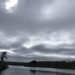
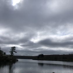
This park is awesome! You can do a simple fairly flat walk around the lake at about 4 miles or venture off up the mountain and make a hike as long as 15+ miles if you wanted to do so. I love that this place has so much history and the visitor center fills in the blanks as to why you pass certain structures along the trails providing historic details. I love the huge 3D map they have at the visitor center that can highlight hiking routes with visible lights on the map they provide to give you a nice visual representation of what your journey will look like. Not far from home this is becoming a local favorite spot that I certainly want to visit several times over to hike the entire system of trails.

I'm always mystified at how many people are obsessed with nearby Harriman and yet have never heard of, much less been, to this park. It's one of my absolute favorite places in the area to hike, and because it's still a bit of a hidden gem, it's not very crowded and the wildlife sightings are always excellent. I came by this past Saturday morning for one of my classic hikes, a 7.5-mile lollipop up to Bare Rock. Same starts over by the Visitor Center (huge fan of the Center - it has bathrooms and an awesome 3D interactive map; you can click buttons to light up certain suggested trails/hikes) on the blue Sterling Lake Loop trail, goes on the road alongside Sterling Lake for a few minutes, then turns left on the orange Bare Rock trail up to the summit, continuing south to its terminus, then left on the green West Valley/red Fire Tower trails until you hit the "stick" of the lollipop again, returning down the Bare Rock trail. The markings on all the trails are very good - intersections are usually noted with a formal wooden sign, along with mileage updates to certain areas (e.g., Route 17A parking lot and the fire tower). Difficulty-wise, this is moderate to strenuous in my opinion. I'm in pretty good hiking shape so I'm usually a little tuckered out by the end but nothing egregious. The climb up to the summit is probably the toughest part but the incline isn't too dramatic and it's early enough in the hike where your haunches shouldn't be tired. The last 40% or so of the hike is either flat or mostly downhill. The view at the summit is worth the sweat - I'm hard-pressed to think of a better optic in the area. It's gorgeous up there and you can see just about the entirety of Greenwood Lake. The rest of the orange trail is a bit meh in terms of personality, but towards the end has a very pleasing batch of rhododendron draping over the path, almost like a tunnel. Shortly after you start back on the red/green trail, there's a very pretty pond with several beaver dams. This is close to where I encountered my Wildlife Sighting of the Day, likely a black racer or black rat snake. Very accommodating creature that appeared to tilt his head up to the camera. A real professional. On prior visits, I've seen wild turkeys and a bear - this is legit nature out here. The canine situation was inexplicably lacking. It was about 60 degrees and gorgeous out, and yet I didn't see a single pooch until I was back on the road to the Visitors Center. This is usually teeming with quality canines though so I have to assume it was just a troubling anomaly. I usually park in the lot across the street from the Visitors Center, which consistently has one of the cleanest port-a-potties I've ever frequented. When is the last time you used one and didn't smell an earlier visit? Fine, fine work on that front. Beyond my specific hike, you have a lot of options in terms of environment, visuals and terrain. You can hike around the lake, seek a mid-ridge trail that goes to the Fire Tower (that seems to be the most crowded area in my experience) or go all the way up to the top like I did and take in the sights. You can't go wrong with any of them.

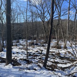
My husband an I had planned to jog the 4 mile trail around the lake. Do not do this. This is a hiking trail with lots of loose rocks and roots covering the trail. Even though our exercise goals had been ruined, we still had an amazing time! It was a beautiful trail that takes you deep into the woods. The path is clearly marked and easy to follow. At mile 2 you reach the lake. We learned all about the iron mining and it was very interesting too see. Beware of the poison ivy


Sterling Forest Park is filled with beautiful natural features and a web of great trails including the Appalachian trail. The visitor center is situated on Sterling Lake. Inside there is a large model of the park. You can select buttons that light up the trails on the model. The park rangers are very helpful in planning a hike. I chose to hike up to the fire tower which you can climb and enjoy an unobstructed view of the surrounding area. I highly recommend downloading the free "pdf maps app" and downloading the free pdf map of Sterling Forest. Turn your phone on airplane mode to save battery because there's little cell phone service but your GPS will still work and show your position on the map.


6 months ago


I loved my hike 5 mile hike in Sterling Forest State Park. We did the Doris Duke loop which was just under 5 miles. We started the hike going clockwise, and in so doing did most of the elevation gain at the start of the hike. I found the path to be very comfortable to walk on, with less rocks and exposed tree roots than typical for NYS. I was also very surprised at how peace full it was, we did not see another living soul until we were 2/3s of the way through the hike, and then didn't see anyone else until we got to the parking lot. I was all set to only hike in this park going forward, because Harriman can get way too busy for me, and then the ticks started. SO MANY Ticks. I hike frequently and ticks are a fact of life in the north east, but this was next level tick infestation. I tuck my pant bottoms into my boots and spray tick repellent on my clothes, boots, and arms. We were pulling them off ourselves in the car on the drive home, and then off ourselves at home. Thank god they were the large size kind of tick and easy to see. I have never seen so many ticks at one time. 100% avoid Sterling Forest. read more


We've hiked in Sterling Forest several times and have enjoyed the experience! Typically less crowded than Harriman State Park and others in the area, Sterling has a very nice visitor center with clean bathrooms, a helpful light up model of the forest, a store, and friendly staff to help with any questions. The parking lot is decent sized too. They have some varied hikes but most aren't too difficult. Whether you want lakes, forests or views you can get them here. Many of the trails also connect if you want to make them longer or shorter. Some of the hikes like Mckeags in the summer can be very tick ridden so do all the usual precautions. There's spotty reception in this area so if you're using All Trails or other app, you'll want offline view. read more


7 months ago
PROS: Many nice trails and abandoned structures along some of the trails. The visitor center is beautiful, the lake is huge, and the paths are clear CONS: It's hard to find parking on the main road in order to start hiking on the trailhead OVERALL: As long as you know where to go for parking, I highly recommend coming here read more


This park is awesome! You can do a simple fairly flat walk around the lake at about 4 miles or venture off up the mountain and make a hike as long as 15+ miles if you wanted to do so. I love that this place has so much history and the visitor center fills in the blanks as to why you pass certain structures along the trails providing historic details. I love the huge 3D map they have at the visitor center that can highlight hiking routes with visible lights on the map they provide to give you a nice visual representation of what your journey will look like. Not far from home this is becoming a local favorite spot that I certainly want to visit several times over to hike the entire system of trails. read more


I'm always mystified at how many people are obsessed with nearby Harriman and yet have never heard of, much less been, to this park. It's one of my absolute favorite places in the area to hike, and because it's still a bit of a hidden gem, it's not very crowded and the wildlife sightings are always excellent. I came by this past Saturday morning for one of my classic hikes, a 7.5-mile lollipop up to Bare Rock. Same starts over by the Visitor Center (huge fan of the Center - it has bathrooms and an awesome 3D interactive map; you can click buttons to light up certain suggested trails/hikes) on the blue Sterling Lake Loop trail, goes on the road alongside Sterling Lake for a few minutes, then turns left on the orange Bare Rock trail up to the summit, continuing south to its terminus, then left on the green West Valley/red Fire Tower trails until you hit the "stick" of the lollipop again, returning down the Bare Rock trail. The markings on all the trails are very good - intersections are usually noted with a formal wooden sign, along with mileage updates to certain areas (e.g., Route 17A parking lot and the fire tower). Difficulty-wise, this is moderate to strenuous in my opinion. I'm in pretty good hiking shape so I'm usually a little tuckered out by the end but nothing egregious. The climb up to the summit is probably the toughest part but the incline isn't too dramatic and it's early enough in the hike where your haunches shouldn't be tired. The last 40% or so of the hike is either flat or mostly downhill. The view at the summit is worth the sweat - I'm hard-pressed to think of a better optic in the area. It's gorgeous up there and you can see just about the entirety of Greenwood Lake. The rest of the orange trail is a bit meh in terms of personality, but towards the end has a very pleasing batch of rhododendron draping over the path, almost like a tunnel. Shortly after you start back on the red/green trail, there's a very pretty pond with several beaver dams. This is close to where I encountered my Wildlife Sighting of the Day, likely a black racer or black rat snake. Very accommodating creature that appeared to tilt his head up to the camera. A real professional. On prior visits, I've seen wild turkeys and a bear - this is legit nature out here. The canine situation was inexplicably lacking. It was about 60 degrees and gorgeous out, and yet I didn't see a single pooch until I was back on the road to the Visitors Center. This is usually teeming with quality canines though so I have to assume it was just a troubling anomaly. I usually park in the lot across the street from the Visitors Center, which consistently has one of the cleanest port-a-potties I've ever frequented. When is the last time you used one and didn't smell an earlier visit? Fine, fine work on that front. Beyond my specific hike, you have a lot of options in terms of environment, visuals and terrain. You can hike around the lake, seek a mid-ridge trail that goes to the Fire Tower (that seems to be the most crowded area in my experience) or go all the way up to the top like I did and take in the sights. You can't go wrong with any of them. read more


2 years ago
6 years ago
My husband an I had planned to jog the 4 mile trail around the lake. Do not do this. This is a hiking trail with lots of loose rocks and roots covering the trail. Even though our exercise goals had been ruined, we still had an amazing time! It was a beautiful trail that takes you deep into the woods. The path is clearly marked and easy to follow. At mile 2 you reach the lake. We learned all about the iron mining and it was very interesting too see. Beware of the poison ivy read more


8 years ago
Great Hunting and Fishing and Hiking , but NO camping WTF ? Why? Now at least hunting is allowed in October ! 2 stars maybe ?! read more

6 years ago
Wish I stayed here longer just to explore on my own. Did end up seeing the lake & it was beautiful. read more


Sterling Forest Park is filled with beautiful natural features and a web of great trails including the Appalachian trail. The visitor center is situated on Sterling Lake. Inside there is a large model of the park. You can select buttons that light up the trails on the model. The park rangers are very helpful in planning a hike. I chose to hike up to the fire tower which you can climb and enjoy an unobstructed view of the surrounding area. I highly recommend downloading the free "pdf maps app" and downloading the free pdf map of Sterling Forest. Turn your phone on airplane mode to save battery because there's little cell phone service but your GPS will still work and show your position on the map. read more


11 years ago


8 years ago
5 years ago
7 years ago
First time hiking here. Alison at the visitor center was very welcoming and helpful. She gave us maps and thoroughly described and reviewed the trail. We felt very confident venturing forth. We did the fire tower trail, which is actually a loop with the tower about halfway through. The first half is more challenging than the second half. The second half is more of a cleared road/path. You could actually do the path in reverse, doing the second half first, go to the tower, and then go back the same way. That would be the easiest. However you don't have to have much experience to do the whole thing. It took us about 2h 15 min. It's about 4 miles. There's some run down old buildings along the way that are really cool to explore. Bring water and some snacks. We saw a big black snake along the way. Just be aware of your surroundings. You also pass by the lake which is really pretty. You can climb up the fit tower and see the views. You can actually see NYC from up there. read more


11 years ago
13 years ago
More info about Sterling Forest State Park
Ask the Community - Sterling Forest State Park
Review Highlights - Sterling Forest State Park
You might also consider


Why does Yelp recommend reviews?
1 review that is not currently recommended
The reviews below are not factored into the business's overall star rating.
10 years ago
Sterling Forest State Park - hiking - Updated May 2026
Best of Tuxedo Park
People found Sterling Forest State Park by searching for…
Hiking Trails With Waterfalls in Tuxedo Park, New York
Things to Do in Tuxedo Park, New York
Fishing in Tuxedo Park, New York
Star Gazing in Tuxedo Park, New York
Campgrounds in Tuxedo Park, New York
Playgrounds in Tuxedo Park, New York
Scenic View in Tuxedo Park, New York
Lakes & Ponds in Tuxedo Park, New York
View Points in Tuxedo Park, New York
Swimming Lakes in Tuxedo Park, New York
Dog Swimming in Tuxedo Park, New York
Secret Spots in Tuxedo Park, New York
Parks for Kids in Tuxedo Park, New York
Scenic Drive in Tuxedo Park, New York
Camping Sites in Tuxedo Park, New York
Waterfalls and Swimming Holes in Tuxedo Park, New York
Water Parks in Tuxedo Park, New York
Places to Take Pictures in Tuxedo Park, New York
Beautiful Views in Tuxedo Park, New York
Scenic Overlook in Tuxedo Park, New York
Off Road Trails in Tuxedo Park, New York
Nature Trails in Tuxedo Park, New York
Trending Searches in Tuxedo Park, NY
Baseball Fields near Sterling Forest State Park
Botanical Gardens near Sterling Forest State Park
Bounce House Rentals near Sterling Forest State Park
Campgrounds near Sterling Forest State Park
Cliff Jumping near Sterling Forest State Park
Flower Shop near Sterling Forest State Park
Garage Sales near Sterling Forest State Park
Garden Center near Sterling Forest State Park
Hair near Sterling Forest State Park
Nurseries & Gardening near Sterling Forest State Park
Off Leash Dog Parks near Sterling Forest State Park
Outdoor Activities near Sterling Forest State Park
Outdoor Basketball Courts near Sterling Forest State Park
Outdoor Furniture Stores near Sterling Forest State Park
Party Equipment Rentals near Sterling Forest State Park
Pedicure near Sterling Forest State Park
Pick Your Own Farms near Sterling Forest State Park
Picnic Areas near Sterling Forest State Park
Picnic Spots near Sterling Forest State Park
Places To Take Pictures near Sterling Forest State Park
Plant Nursery near Sterling Forest State Park
Running Trails near Sterling Forest State Park
Rv Rental near Sterling Forest State Park
Scenic Drive near Sterling Forest State Park
Secret Spots near Sterling Forest State Park
Splash Pad near Sterling Forest State Park
Strawberry Picking near Sterling Forest State Park
Swimming Holes near Sterling Forest State Park
Tennis Courts near Sterling Forest State Park
Browse Articles
Browse Nearby
BEST of Tuxedo Park, New York Restaurants near Sterling Forest State Park
BEST of Tuxedo Park, New York Coffee near Sterling Forest State Park
BEST of Tuxedo Park, New York Things to Do near Sterling Forest State Park
BEST of Tuxedo Park, New York Breakfast near Sterling Forest State Park
BEST of Tuxedo Park, New York Hotels near Sterling Forest State Park
Browse Brands
Related Searches in Tuxedo Park, NY
Best Fishing Locations and Guides in Tuxedo Park, New York
Best Fun Things to Do in Tuxedo Park, New York
Best Off Leash Dog Parks in Tuxedo Park, New York
Best Parks for Parties and Events in Tuxedo Park, New York
Best Places for Horseback Riding in Tuxedo Park, New York
Best Sledding Spots and Fun in Tuxedo Park, New York
Best Spots for Star Gazing in Tuxedo Park, New York
Check Out Great Playgrounds in Tuxedo Park, New York
Check Out Off Road Trails in Tuxedo Park, New York
Discover Baseball Fields Around Tuxedo Park, New York
Discover Kids Indoor Play Area Venues in Tuxedo Park, New York
Discover Soccer Fields in Tuxedo Park, New York Near You
Discover Top Boat Tours in Tuxedo Park, New York for All Ages
Discover Top Nature Parks to Visit in Tuxedo Park, New York
Discover a Hiking Trail in Tuxedo Park, New York
Discover the Best Beaches in Tuxedo Park, New York
Discover the Best Night Hike Trails in Tuxedo Park, New York
Dog-Friendly Hikes With Dogs in Tuxedo Park, New York
Enjoy Camping Adventures Around Tuxedo Park, New York
Enjoy Exciting Mountain Biking Adventures in Tuxedo Park, New York
Enjoy Kayaking Adventures in Tuxedo Park, New York
Enjoy a Beautiful Waterfall Hike in Tuxedo Park, New York
Enjoy the Best Picnic Spots and Ideas in Tuxedo Park, New York
Enjoy the Best Tubing Experiences in Tuxedo Park, New York
Enjoy the Best Walking Trails in Tuxedo Park, New York
Explore Beautiful Botanical Gardens in Tuxedo Park, New York
Explore Beautiful Parks and Green Spaces in Tuxedo Park, New York
Explore Bike Rentals Throughout Tuxedo Park, New York
Explore Easy Hikes Perfect for All in Tuxedo Park, New York
Explore Family-Friendly Zoos and Wildlife in Tuxedo Park, New York
Explore Free Picnic Areas Around Tuxedo Park, New York
Explore Jet Skis for Sale or Rent in Tuxedo Park, New York
Explore Landmarks & Historical Buildings in Tuxedo Park, New York
Explore Parks With Pull Up Bars in Tuxedo Park, New York
Explore Popular Campgrounds Near Tuxedo Park, New York
Explore Popular Picnic Areas Around Tuxedo Park, New York
Explore Popular RV Parks Around Tuxedo Park, New York
Explore Popular Recreation Centers Around Tuxedo Park, New York
Explore Popular Scenic Overlook Points in Tuxedo Park, New York
Explore Scenic Lakes to Visit in Tuxedo Park, New York
Explore Secret Spots Worth Visiting in Tuxedo Park, New York
Explore Top Dog Parks in Tuxedo Park, New York Near You
Explore Top Gyms in Tuxedo Park, New York Now
Explore Top Water Parks in Tuxedo Park, New York Today
Explore the Best Boating Spots in Tuxedo Park, New York
Explore the Best Swimming Holes Around Tuxedo Park, New York
Family Friendly Hiking With Kids in Tuxedo Park, New York
Find Beautiful Views in Tuxedo Park, New York
Find Parks and Recreation Activities in Tuxedo Park, New York
People who viewed Sterling Forest State Park also viewed
Harriman State Park
105 reviews
Storm King State Park
31 reviews
Constitution Marsh Audubon Center And Sanctuary
11 reviews
Bear Mountain State Park
271 reviews
Black Rock Forest Consortium
6 reviews
Ramapo Mountain State Forest
24 reviews
Apshawa Preserve
7 reviews
Stairway to Heaven
92 reviews
Reeves Meadow Information Center
6 reviews
Schunemunk Mountain State Park
9 reviews