Norvin Green State Forest Photos


You might also consider
More like Norvin Green State Forest
Recommended Reviews - Norvin Green State Forest
Start your review...

Reviews With Photos

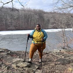
What a win! I would have never found out about Norvin Green if it weren't for Yelp. I love discovering new and beautiful hikes that are in NJ and not far from home. There are a few different trails at Norvin Green and I like how they have light, medium and difficult options. The quickest trail is around 3 miles RT, the middle around 5 and the most difficult is a bit over 7. We opted for the mid-level hike and this was perfect. Most of the hike was shaded which was much appreciated during the hot and sunny day. Although you are ascending it's not too steep and there are clearly marked steps / footholds throughout. It felt a bit challenging at times, but certainly not difficult. Once you reach the top the views of the water are stellar. There are lots of rocks to sit on if you want to relax and enjoy a snack. At the end of the hike we were also surprised with waterfalls which was such a nice treat. This hike is scenic 100% of the time, has a variety of options for different skill levels, and is a worthwhile way to spend a few hours. Highly suggest visiting Norvin Green!

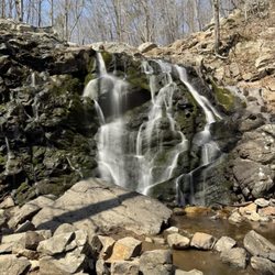
As the weather gets better, I wanted to go experience the nature you forget is right around the corner from all the city life of Northern NJ. It's a great way to experience the forest while also you're not in the middle of the Appalachian trail never to see anyone in case of an incident. I do recommend either downloading a trail map to your phone in case you lose reception, but I always had reception which is comforting to a novice. Plan your trails, and I recommend making the waterfall one of the stops. I got to the park early in the day, and when I was leaving the parking lot was full, so take that into account. There are other parking lots around, but I recommend coming before noon. There are some beautiful views looking over a river, obviously the waterfall looks great, some of the paths go across streams which was an excerise in rock navigation. I saw a snake! Carris Hill trail is steep! Little loose with the word hill. It's a challenge! Other tips: 1) BRING TOO MUCH WATER. I brought 3 bottles in my backpack for me and it was barely enough. If I had a fourth I wouldn't have rationed some of it at the end. Especially if you walk far and have to walk back, you'll prefer having the water than none. Get a backpack/satchel so it's easy to lug around. 2) I got a little turned around on one of the trails, so downloading a trail map so I knew exactly where I was was super helpful. Google Maps just knows you're in teh forest and the map just shows the trails, so if you're unsure which fork you're on, there are apps that show your exact location on the map with distances can be really helpful. 3) Watch your footing as it's easy to trip while looking around on tree roots and rocks. Wear appropriate footwear. I ended up seeing quite a number of people on the trails but not too much. A good mix of isolation with my thoughts and a mix of knowing if I did fall and hurt myself, someone would find me. Also saying hello to people doing the same activity gives a sense of camaraderie. When it's hot but not TOO hot, this was a nice park to get away from the city life for a few hours.

Gorgeous forested trails with killer views! Known for its High Point, this popular hiking spot takes you 3 miles deep into nature with many look out points along the way. Endure all 3 miles of rocks, dirt roads, and occasional watery streams and your eyes are in for a treat! The view shows you hundreds of lush green trees, hawks gliding around, and some glistening lakes that are afar. Few important things to note is that these trails aren't super dog friendly, there is a lot of terrain and if you are planning on bringing your pup make sure they are up for the challenge. No garbages around as well as no public bathrooms so think twice before chugging your bottle of water! This hiking spot would be a 5 out of 5 for me if the parking wasn't so troublesome, with a lot of a max of 3 cars and another of about 10, if you don't get here at the crack of dawn and get a side road spot, not sure what to tell you!
FIrst hike during the pandemic! My fiance and I have been avoiding any hiking spots during the weekend because we want to avoid the crowds. So we decided to take a Monday off (had to be during the heatwave, of course) to go check out this park. We got there a little bit after 9. There's a small parking area (fits maybe 6-7 cars) which was almost full already. Although I'm sure there are different trail entrances and areas to park. As we were entering the trail, we saw one lady leaving but other than that, we didn't see a single soul on the trail the entire time. A little eerie but it was nice to have the entire trail to ourselves. I think it was probably because it was a Monday couples with the fact that it would also be 95 degrees (real feel 100 something) later in the afternoon. But we went early enough so it wasn't crazy hot yet, and 90% of the hike was in the shade. We did the blue diamond trail leading into the yellow trail, which I believe is 2.6 miles. The hike itself is definitely a little harder than a beginner trail. There are some rocky areas you have to climb. Once you get to the top, that's where it's blazing. There is no shade at all up there so don't expect any. But it's pretty up there! I can't say how it would be on a weekend but I'd recommend just taking a day to go during the week. It's not like we're saving those vacation days for anything else this year anyway!
")
The views on this hike were amazing! We decided to hike a loop (took a few different colored trails) and were able to see the water and the skyline from the High Point. I would definitely visit again! When we arrived a bit before 10ish, almost half of the parking lot was full. By 10:30/11ish, the parking lot was PACKED. Before starting, take a picture of the map on the bulletin board. Some of the trail markers are difficult to spot, so it's easy to accidentally go off-trail. The hike we took was pretty medium-leveled. There were good footholds throughout the hike and there was a lot of shade, however the majority of it was really rocky so make sure you wear appropriate shoes and always watch your step. Also, bring lots of water and a few snacks! (Remember to take your garbage with you) You'll definitely need water/snacks during the hike and there are tons of great resting points on the trails. As an additional FYI, there aren't any restroom facilities here.

Great challenging trails in this New Jersey State Park, absolutely outstanding views if you make the climb, but parking can be difficult. Norvin Green has a big network of trails, well marked with paint blazes on trees, and rocks are everywhere so wear boots. This review is for a strenuous hike called Chikahoki Falls in the All Trails app. You park and start near the town of Bloomingdale, travel about 4 miles and climb about 1000 feet, up to the peak for the views and back down again on the Highland Trails blue, yellow and white trails. We crossed many wet/marshy areas, also a couple streams via rocks and logs. The falls themselves are modest, but at the top the view to the east is stunning, we saw Manhattan very clearly in the distance. Leaves made the climbs & descents a challenge. We saw almost no trash on the trail. Over three hours we saw about 30 people, that seemed like almost nobody But the tiny dirt parking lot near Bloomingdale was full. Knocking off a star for the poor parking, if the state would just paint lines or mark it better, people would park better & safely, fit more cars etc.

I spent most of the day hiking Norvin Green State Forest. I recommend the early Fall hiking because of the average temperatures, usually dry trails and of course the Autumn foliage colors. Norvin Green has an extensive trail system which links up with public and private properties. some trails continue beyond the State forest limits. I began at the New Weis Center. The center is mostly used for outdoor education. There are limited exhibits to view. After exploring the center I began my hike which took me to the Natural Pool which was about a 10 minute walk. From there I hiked to the Wyanokie High Point. It is a interesting hike which is by in large hiked in the shade of trees except near the top which is steep and rock faced. I would consider the hike medium to difficult for the East Coast of the United States. Other nearby hiking trails from the New Weis Center are Ball Mountain and Carris Hill which is a difficult hike. Norvin Green State Forest offers a variety of hiking experiences. While Carris Hill (yellow blaze) is 1 mile and difficult, Otterhole (green blaze) is 1.5 miles and of medium difficulty and Macopin (white blaze ) is 1 mile and easy. Of the 10 trails offered (1 is easy), (3 are medium) and (6 are difficult). Trail distances range from 1 mile 5 trails, 1.5 miles 2 trails, 1 trail 4.0 miles, 1 trail 5 miles and 1 trail is 5.5 miles. Elevations range from 400'to 1,300' above sea level. There are scenic vistas of the New York skyline, Burnt Meadow Brook, Lake Sunoma and Wanaque reservoir. Use a topographical map to avoid getting lost. Maps can be purchased at the New Weis Center or through the New York-New Jersey Trails Conference. There are multiple entry points to Norvin Green State forest, each has a parking lot but different capacity. I have seen black bears on the trail on several occasions.

Great views throughout this trail. Check out NJHiking.com before you go to review the trail(s) you plan to take because some of the blazes are hard to spot and it's easy to get turned around. Make sure you get to the lot early on a weekend, tends to get very packed by 1030-11. Easily could have sold my parking spot.

We went specifically to Wyanokie Hi Point. There was a different path for hikers with dogs and on this you could start slightly left from the parking lot, passing a residential area briefly before treading on a clear path, then crossing a small patch of shallow and leafy water, and from here the hike started. The trail can be bumpy from rocks with a tendency to go down before going up, then down again. But the path afforded nice scenery, I like this trail better than Bear Mountain. We rarely crossed path with anyone. The view on top was definitely an opportunity for beautiful photos. Here, was a very peaceful vibe; just the right breeze and perfect view of the foliage to soak up on. This was 17Oct2020. Manhattan Skyline could be detected like a grey sketch from up here. We were there at around 0945 and there were probably 5 spots left in the parking lot, but full to the brim as we left past noontime. There were more people as we took the short cut, on our way back. The trail was way steeper! My thighs felt like it was doing squats, by this time, but then again, it's coming from someone who never engage in regular exercise.

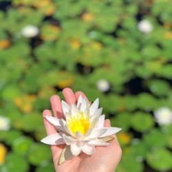
Love this place. The trails are marked (green at the bottom and blue as you are ascending to the top) so it's fairly easy to find your way to the top and back down even if you have a terrible sense of direction, just make sure you keep an eye out for the different colored markers on the trees and stones, some are easy to miss! We were told it was a "strenuous" hike but personally I didn't think it was that bad. It took us around 3 1/2 hours to do the entire hike. Some parts are definitely challenging and I was sweating A LOT but it was also 85 degrees and humid when we did this hike. The views were absolutely gorgeous! I loved it! I can't wait to come back in the fall. At the bottom of the mountain there's a natural pool. It's not chlorinated or anything but still super clean!!! The water comes from the stream from the top of the mountain. There's a $10 entrance fee per person with tons of picnic tables on the side of the pool. There were lots of people swimming and bbqing when we came. There's also a little shop by the pool where they sell snacks, food & drinks. There's also a volleyball net and basketball hoop out in the field next to the pool. This park has so much to offer and there's NO entry fee either! If you live close I highly recommend checking it out! Tip: If you plan on doing the hike make sure you wear sneakers with good grip and I recommend bringing a backpack full with water. We brought 4 bottles of water and went through them all on the way up.

Wyanokie High Point, Ringwood NJ. Awesome moderate hiking trail, easy to follow. Can get crowded on the weekends, but helps to point you in the right direction. I used my hiking trails app as a guide helpful if your hiking solo. View is amazing and worth every minute of the hike. Little challenges along the way, make it all the more exciting. Enormous beautiful boulders lead you to the top.

Soooo many mosquitoes! I came here and went to the Wyanokie High Point, Chikahoka Falls, and the Otter Hole. The hike was pretty nice, and it was pretty shaded which made the hike more enjoyable. It also wasn't too steep, and even though the waterfall and the Otter Hole were a bit dry, the view at the top was good! Cool hike, and I'm glad I went! Bring bug repellent too!

First hike of 2016, on a Wednesday and it was at Norvin Green State Forest in New Jersey, with a small group of friends. Drive from Queens, wasn't that bad; an hour and change via the Tappan Zee Bridge (We took the more scenic route). Upon arrival at the New Weis Center, we were the only other car there, aside from this black Honda. Near the parking lot, we saw a few residential homes. I couldn't imagine living there..in the middle of nowhere. While my friends and I were preparing our gear and backpacks, this gentlemen wearing slacks, dress shirt and shoes walked out of the woods...I recall my friends and I looking at one another like, "What the hell? Clearly this guy isn't dressed properly. What was he doing in the woods? Getting rid of a body perhaps..?" O_o Anyway, my friends and I decided on hiking the Wyanokie High Point Loop from the parking lot, which is roughly 4 miles long and has several steep ups and downs, making this hike a moderately strenuous hike. At the beginning of the trail, there is an information booth with up-to-date trail maps and other useful information. We followed the blue trail, which was mostly through the woods. Terrain was climbing in elevation for the most part, with a few down slopes as well. We noticed many downed trees and there was a small brook near the beginning of the trail. The blue trail, we followed all the way to the High Point, which is the highest point of the Wyanokie Loop (obviously). From there, we saw nice panoramic views of surrounding forest, and the Wanaque Reservoir. And if you focus your eyes farther in the distance, you can actually see the NYC skyline and just make out the silhouette of the Empire State building and the Freedom Tower (Pretty cool!). On our way back, we followed the blue and white/red trail markers back down, until we came to the part of the trail where Blue meets Yellow. Along the descent back to the parking lot, we saw 2 pairs of hikers as well, so it was definitely relieving to know that we weren't along in the woods..LOL Overall, my friends and I were quite satisfied with our first hike of the year. Norvin Green State Forest has a nice extensive trail system, with well marked trails for the most part. The highest difficulty level is probably the Wyanokie Loop, which seemed to have the highest elevation level. I could see this place being beautiful in the Fall when all the leaves change color, or perhaps even in the winter months, the day after a snowstorm and the landscape is covered in a layer of snow!

I love the outdoors , but this hike was not my favorite :( it has an absurd amount of insects and YES I know it's a forest , but it not even well kept when it comes to markers on the trees for hikers . You can easily get lost because there's barely any markers or directions . The view from the summit is ok but even that doesn't have a sign either . They have bathroom signs to bathrooms that don't exist . Parking to a lot that says private lot .. nature is beautiful . But I wouldn't recommend this place , the pictures posted here are the ONLY thing to see . DO NOT RECOMMEND !!! There are other beautiful hiking places .. read more


Norvin Green is one of my absolute favorite places in NJ to hike. It has a tremendous variety of trails with different terrain, difficulty level and unique environments; if the mood strikes you, it's possible to hike up and down a few mountains with gorgeous 360-degree views, or something much easier that involves exploring some of the mines on the eastern side of the forest, closer to the reservoir. There's something for virtually any type of hiker, and because so much of the area is rugged, you're not likely to find too many ignorant young hiking pups wandering aimlessly without water or a map. I usually get out here at least a few times every year, and most recently stopped by with one of my chums two Saturdays ago for an 8.1-mile hike. If you're approaching Norvin Green from 287, I would strongly recommend stopping by the Quick Chek on 511 - the bathroom options are pretty much non-existent in the forest (apart from strategically placed foliage), the employees there are always very pleasant and you have a lot of hiking snack options if you haven't had time to preplan that aspect of the adventure. We did a circuitous route beginning at the Weis parking lot up the green trail, past the natural pool to the kiosk, then up blue to Wyanokie High Point, back down and continuing on the blue trail to Carris Hill, then taking the yellow trail from there down into the wetlands, turning west onto the blue trail, past Chik Falls and over to Otter Hole. At that point, you can either take the green Otter Hole trail back to the kiosk (I think that's about 6 miles), or turn west again in .2 miles onto yellow and up Buck Mountain, meandering along the ridge until you hit the woods road (subjective term) and can follow it back to the green trail/kiosk. Deciding to incorporate Buck Mountain adds about two miles to the trip, so if your haunches aren't up to it, just keep going north on green. You'll still get a workout in, regardless. The climb up to Wyanokie is fairly strenuous. I'm in very good hiking shape and can do it without any breaks if needed, but you're definitely earning the views once you ascend past the main tree line. The view on top has to be one of the top two or three in the state; on a clear day, you can see the NYC skyline (that's true as well for the top of Buck Mountain and several points along the yellow trail before it descends), as well as the mountainous regions to the north and west. It's gorgeous, and the only damper on this particular day was the obvious effects of the seasonal drought - tons of brown foliage and several of the water features were dried up or close to it. Especially down in the wetlands, you're usually hopping over a small stream or two. Not on this day, and Chik Falls was a barely discernable trickle. The Buck Mountain climb is one of the toughest in the area - if you can do it without taking a breather, god bless. It's something like an 800-foot ascent in .1 miles; it doesn't require actual rock scrambling or climbing, but it's probably in the tier right below that. But as with Wyanokie, you're getting amazing views for the sweat expended on the incline, and because it's a nastier section of the forest, there isn't nearly as much foot traffic. It's not unusual to get some solid wildlife sightings up on the ridge. This particular hike certainly had its share of wildlife. We saw either a garter or ribbon snake with Pittsburgh Steelers coloring, a skink, AKA the corgi of lizards, oodles of small frogs (presumably panicking over the lack of water), and met two canine chums, Nala and Argo. A very solid crop, and not out of the ordinary for this area. I couldn't recommend this place more highly. Nearby Wanaque doesn't have a lot of great eating options, so given that you've more than earned your calories from tromping around in the woods, I'd venture a little further south to sup on scrumptiousness. read more


This was the first time I did a trail that was rated hard on my own. I wanted to see the waterfall and then make it to the top of the mountain. I didn't prepare enough and I warn you not to make the same mistake as I did. I found the waterfall easy enough. I had to follow a few different colored markers to get to the top of the mountain. The trail isn't obvious and there is a lot of areas where you are climbing rocks and leaves. There are a few lookouts on the way to "high point". "High point" was absolutely amazing. I was completely surrounded by nature on all sides and had a religious experience on top of the mountain. It was amazing. Of course I ended up coming out of the mountain on the wrong side and it was nearly dark so I didn't want to go back into the forest. I walked so far in the rain and somebody was nice enough to pick me up. My car didn't start when I finally got there, but that's a different story altogether. This was probably the best hike I've been on. I just ordered a personal navigation device and some other tools for my next hike and cannot emphasize enough for you to be prepared. read more


What a win! I would have never found out about Norvin Green if it weren't for Yelp. I love discovering new and beautiful hikes that are in NJ and not far from home. There are a few different trails at Norvin Green and I like how they have light, medium and difficult options. The quickest trail is around 3 miles RT, the middle around 5 and the most difficult is a bit over 7. We opted for the mid-level hike and this was perfect. Most of the hike was shaded which was much appreciated during the hot and sunny day. Although you are ascending it's not too steep and there are clearly marked steps / footholds throughout. It felt a bit challenging at times, but certainly not difficult. Once you reach the top the views of the water are stellar. There are lots of rocks to sit on if you want to relax and enjoy a snack. At the end of the hike we were also surprised with waterfalls which was such a nice treat. This hike is scenic 100% of the time, has a variety of options for different skill levels, and is a worthwhile way to spend a few hours. Highly suggest visiting Norvin Green! read more


6 years ago
As the weather gets better, I wanted to go experience the nature you forget is right around the corner from all the city life of Northern NJ. It's a great way to experience the forest while also you're not in the middle of the Appalachian trail never to see anyone in case of an incident. I do recommend either downloading a trail map to your phone in case you lose reception, but I always had reception which is comforting to a novice. Plan your trails, and I recommend making the waterfall one of the stops. I got to the park early in the day, and when I was leaving the parking lot was full, so take that into account. There are other parking lots around, but I recommend coming before noon. There are some beautiful views looking over a river, obviously the waterfall looks great, some of the paths go across streams which was an excerise in rock navigation. I saw a snake! Carris Hill trail is steep! Little loose with the word hill. It's a challenge! Other tips: 1) BRING TOO MUCH WATER. I brought 3 bottles in my backpack for me and it was barely enough. If I had a fourth I wouldn't have rationed some of it at the end. Especially if you walk far and have to walk back, you'll prefer having the water than none. Get a backpack/satchel so it's easy to lug around. 2) I got a little turned around on one of the trails, so downloading a trail map so I knew exactly where I was was super helpful. Google Maps just knows you're in teh forest and the map just shows the trails, so if you're unsure which fork you're on, there are apps that show your exact location on the map with distances can be really helpful. 3) Watch your footing as it's easy to trip while looking around on tree roots and rocks. Wear appropriate footwear. I ended up seeing quite a number of people on the trails but not too much. A good mix of isolation with my thoughts and a mix of knowing if I did fall and hurt myself, someone would find me. Also saying hello to people doing the same activity gives a sense of camaraderie. When it's hot but not TOO hot, this was a nice park to get away from the city life for a few hours. read more


Gorgeous forested trails with killer views! Known for its High Point, this popular hiking spot takes you 3 miles deep into nature with many look out points along the way. Endure all 3 miles of rocks, dirt roads, and occasional watery streams and your eyes are in for a treat! The view shows you hundreds of lush green trees, hawks gliding around, and some glistening lakes that are afar. Few important things to note is that these trails aren't super dog friendly, there is a lot of terrain and if you are planning on bringing your pup make sure they are up for the challenge. No garbages around as well as no public bathrooms so think twice before chugging your bottle of water! This hiking spot would be a 5 out of 5 for me if the parking wasn't so troublesome, with a lot of a max of 3 cars and another of about 10, if you don't get here at the crack of dawn and get a side road spot, not sure what to tell you! read more


FIrst hike during the pandemic! My fiance and I have been avoiding any hiking spots during the weekend because we want to avoid the crowds. So we decided to take a Monday off (had to be during the heatwave, of course) to go check out this park. We got there a little bit after 9. There's a small parking area (fits maybe 6-7 cars) which was almost full already. Although I'm sure there are different trail entrances and areas to park. As we were entering the trail, we saw one lady leaving but other than that, we didn't see a single soul on the trail the entire time. A little eerie but it was nice to have the entire trail to ourselves. I think it was probably because it was a Monday couples with the fact that it would also be 95 degrees (real feel 100 something) later in the afternoon. But we went early enough so it wasn't crazy hot yet, and 90% of the hike was in the shade. We did the blue diamond trail leading into the yellow trail, which I believe is 2.6 miles. The hike itself is definitely a little harder than a beginner trail. There are some rocky areas you have to climb. Once you get to the top, that's where it's blazing. There is no shade at all up there so don't expect any. But it's pretty up there! I can't say how it would be on a weekend but I'd recommend just taking a day to go during the week. It's not like we're saving those vacation days for anything else this year anyway! read more


6 years ago
The views on this hike were amazing! We decided to hike a loop (took a few different colored trails) and were able to see the water and the skyline from the High Point. I would definitely visit again! When we arrived a bit before 10ish, almost half of the parking lot was full. By 10:30/11ish, the parking lot was PACKED. Before starting, take a picture of the map on the bulletin board. Some of the trail markers are difficult to spot, so it's easy to accidentally go off-trail. The hike we took was pretty medium-leveled. There were good footholds throughout the hike and there was a lot of shade, however the majority of it was really rocky so make sure you wear appropriate shoes and always watch your step. Also, bring lots of water and a few snacks! (Remember to take your garbage with you) You'll definitely need water/snacks during the hike and there are tons of great resting points on the trails. As an additional FYI, there aren't any restroom facilities here. read more
 - Hiking Near Me - Ringwood, New Jersey")


Great challenging trails in this New Jersey State Park, absolutely outstanding views if you make the climb, but parking can be difficult. Norvin Green has a big network of trails, well marked with paint blazes on trees, and rocks are everywhere so wear boots. This review is for a strenuous hike called Chikahoki Falls in the All Trails app. You park and start near the town of Bloomingdale, travel about 4 miles and climb about 1000 feet, up to the peak for the views and back down again on the Highland Trails blue, yellow and white trails. We crossed many wet/marshy areas, also a couple streams via rocks and logs. The falls themselves are modest, but at the top the view to the east is stunning, we saw Manhattan very clearly in the distance. Leaves made the climbs & descents a challenge. We saw almost no trash on the trail. Over three hours we saw about 30 people, that seemed like almost nobody But the tiny dirt parking lot near Bloomingdale was full. Knocking off a star for the poor parking, if the state would just paint lines or mark it better, people would park better & safely, fit more cars etc. read more


6 years ago
I spent most of the day hiking Norvin Green State Forest. I recommend the early Fall hiking because of the average temperatures, usually dry trails and of course the Autumn foliage colors. Norvin Green has an extensive trail system which links up with public and private properties. some trails continue beyond the State forest limits. I began at the New Weis Center. The center is mostly used for outdoor education. There are limited exhibits to view. After exploring the center I began my hike which took me to the Natural Pool which was about a 10 minute walk. From there I hiked to the Wyanokie High Point. It is a interesting hike which is by in large hiked in the shade of trees except near the top which is steep and rock faced. I would consider the hike medium to difficult for the East Coast of the United States. Other nearby hiking trails from the New Weis Center are Ball Mountain and Carris Hill which is a difficult hike. Norvin Green State Forest offers a variety of hiking experiences. While Carris Hill (yellow blaze) is 1 mile and difficult, Otterhole (green blaze) is 1.5 miles and of medium difficulty and Macopin (white blaze ) is 1 mile and easy. Of the 10 trails offered (1 is easy), (3 are medium) and (6 are difficult). Trail distances range from 1 mile 5 trails, 1.5 miles 2 trails, 1 trail 4.0 miles, 1 trail 5 miles and 1 trail is 5.5 miles. Elevations range from 400'to 1,300' above sea level. There are scenic vistas of the New York skyline, Burnt Meadow Brook, Lake Sunoma and Wanaque reservoir. Use a topographical map to avoid getting lost. Maps can be purchased at the New Weis Center or through the New York-New Jersey Trails Conference. There are multiple entry points to Norvin Green State forest, each has a parking lot but different capacity. I have seen black bears on the trail on several occasions. read more


8 years ago
6 years ago
Great views throughout this trail. Check out NJHiking.com before you go to review the trail(s) you plan to take because some of the blazes are hard to spot and it's easy to get turned around. Make sure you get to the lot early on a weekend, tends to get very packed by 1030-11. Easily could have sold my parking spot. read more

6 years ago
We went specifically to Wyanokie Hi Point. There was a different path for hikers with dogs and on this you could start slightly left from the parking lot, passing a residential area briefly before treading on a clear path, then crossing a small patch of shallow and leafy water, and from here the hike started. The trail can be bumpy from rocks with a tendency to go down before going up, then down again. But the path afforded nice scenery, I like this trail better than Bear Mountain. We rarely crossed path with anyone. The view on top was definitely an opportunity for beautiful photos. Here, was a very peaceful vibe; just the right breeze and perfect view of the foliage to soak up on. This was 17Oct2020. Manhattan Skyline could be detected like a grey sketch from up here. We were there at around 0945 and there were probably 5 spots left in the parking lot, but full to the brim as we left past noontime. There were more people as we took the short cut, on our way back. The trail was way steeper! My thighs felt like it was doing squats, by this time, but then again, it's coming from someone who never engage in regular exercise. read more


Love this place. The trails are marked (green at the bottom and blue as you are ascending to the top) so it's fairly easy to find your way to the top and back down even if you have a terrible sense of direction, just make sure you keep an eye out for the different colored markers on the trees and stones, some are easy to miss! We were told it was a "strenuous" hike but personally I didn't think it was that bad. It took us around 3 1/2 hours to do the entire hike. Some parts are definitely challenging and I was sweating A LOT but it was also 85 degrees and humid when we did this hike. The views were absolutely gorgeous! I loved it! I can't wait to come back in the fall. At the bottom of the mountain there's a natural pool. It's not chlorinated or anything but still super clean!!! The water comes from the stream from the top of the mountain. There's a $10 entrance fee per person with tons of picnic tables on the side of the pool. There were lots of people swimming and bbqing when we came. There's also a little shop by the pool where they sell snacks, food & drinks. There's also a volleyball net and basketball hoop out in the field next to the pool. This park has so much to offer and there's NO entry fee either! If you live close I highly recommend checking it out! Tip: If you plan on doing the hike make sure you wear sneakers with good grip and I recommend bringing a backpack full with water. We brought 4 bottles of water and went through them all on the way up. read more


5 years ago
Wyanokie High Point, Ringwood NJ. Awesome moderate hiking trail, easy to follow. Can get crowded on the weekends, but helps to point you in the right direction. I used my hiking trails app as a guide helpful if your hiking solo. View is amazing and worth every minute of the hike. Little challenges along the way, make it all the more exciting. Enormous beautiful boulders lead you to the top. read more


Soooo many mosquitoes! I came here and went to the Wyanokie High Point, Chikahoka Falls, and the Otter Hole. The hike was pretty nice, and it was pretty shaded which made the hike more enjoyable. It also wasn't too steep, and even though the waterfall and the Otter Hole were a bit dry, the view at the top was good! Cool hike, and I'm glad I went! Bring bug repellent too! read more


First hike of 2016, on a Wednesday and it was at Norvin Green State Forest in New Jersey, with a small group of friends. Drive from Queens, wasn't that bad; an hour and change via the Tappan Zee Bridge (We took the more scenic route). Upon arrival at the New Weis Center, we were the only other car there, aside from this black Honda. Near the parking lot, we saw a few residential homes. I couldn't imagine living there..in the middle of nowhere. While my friends and I were preparing our gear and backpacks, this gentlemen wearing slacks, dress shirt and shoes walked out of the woods...I recall my friends and I looking at one another like, "What the hell? Clearly this guy isn't dressed properly. What was he doing in the woods? Getting rid of a body perhaps..?" O_o Anyway, my friends and I decided on hiking the Wyanokie High Point Loop from the parking lot, which is roughly 4 miles long and has several steep ups and downs, making this hike a moderately strenuous hike. At the beginning of the trail, there is an information booth with up-to-date trail maps and other useful information. We followed the blue trail, which was mostly through the woods. Terrain was climbing in elevation for the most part, with a few down slopes as well. We noticed many downed trees and there was a small brook near the beginning of the trail. The blue trail, we followed all the way to the High Point, which is the highest point of the Wyanokie Loop (obviously). From there, we saw nice panoramic views of surrounding forest, and the Wanaque Reservoir. And if you focus your eyes farther in the distance, you can actually see the NYC skyline and just make out the silhouette of the Empire State building and the Freedom Tower (Pretty cool!). On our way back, we followed the blue and white/red trail markers back down, until we came to the part of the trail where Blue meets Yellow. Along the descent back to the parking lot, we saw 2 pairs of hikers as well, so it was definitely relieving to know that we weren't along in the woods..LOL Overall, my friends and I were quite satisfied with our first hike of the year. Norvin Green State Forest has a nice extensive trail system, with well marked trails for the most part. The highest difficulty level is probably the Wyanokie Loop, which seemed to have the highest elevation level. I could see this place being beautiful in the Fall when all the leaves change color, or perhaps even in the winter months, the day after a snowstorm and the landscape is covered in a layer of snow! read more

 - Hiking Near Me - Ringwood, New Jersey")


9 years ago
11 years ago
Amazing place to hike. Personally, I believe it is one of the best places to hike in NJ. Me and my buddies did Carris Hill, Wyanokie High Point and Buck Mountain -- and started from the Otter Hole and saw the amazing waterfalls. Highly recommend the hike. read more


9 years ago
10 years ago
Beautiful hike! Trails were marked, but took a little too find the start. If you park in the first lot you come to you have to find the trail marker that is labeled L in a circle. We took the blue trail until KY met the green trail and took the green trail back to the beginning. Make sure you side track just a bit to see the gorgeous views of high point. The hike took us about four hours or so, but it was well worth it. I can't wait to go back to explore other trails!! read more


10 years ago
It was awesome here. You have your classic northeast deciduous forest. There were trails, cliffs, waterfalls, etc. Perfect for a weekend hike. read more


10 years ago
I came here again, this time hiking Buck Mountain from Otter Hole, and it's really secured this forest as one of my favorites in NJ. This is a great place to explore if you want to see a bunch of different things in one day (waterfalls, mountain views, streams, rock scrambles, etc.), because it really does have everything. I'll be back soon. read more


9 years ago
More info about Norvin Green State Forest
Ask the Community - Norvin Green State Forest
Review Highlights - Norvin Green State Forest
You might also consider


Why does Yelp recommend reviews?
Norvin Green State Forest - hiking - Updated May 2026
Best of Ringwood
People found Norvin Green State Forest by searching for…
Swimming Holes in Ringwood, New Jersey
Hiking Trails With Waterfalls in Ringwood, New Jersey
Volleyball Courts in Ringwood, New Jersey
Things to Do in Ringwood, New Jersey
Off Road Trails in Ringwood, New Jersey
Scenic Drive in Ringwood, New Jersey
Walking Trails in Ringwood, New Jersey
Scenic View in Ringwood, New Jersey
Photo Spots in Ringwood, New Jersey
Picnic Spots in Ringwood, New Jersey
Lookout Points in Ringwood, New Jersey
Basketball Courts in Ringwood, New Jersey
Scenic Overlook in Ringwood, New Jersey
Parks for Kids in Ringwood, New Jersey
Easy Hikes in Ringwood, New Jersey
Swimming Lakes in Ringwood, New Jersey
Picnic Areas in Ringwood, New Jersey
Beautiful Views in Ringwood, New Jersey
Natural Hot Springs in Ringwood, New Jersey
Trending Searches in Ringwood, NJ
Bird Sanctuary near Norvin Green State Forest
Botanical Gardens near Norvin Green State Forest
Bounce House Rentals near Norvin Green State Forest
Campgrounds near Norvin Green State Forest
Cherry Picking near Norvin Green State Forest
Cliff Jumping near Norvin Green State Forest
Flower Fields near Norvin Green State Forest
Flower Shop near Norvin Green State Forest
Garage Sales near Norvin Green State Forest
Garden Center near Norvin Green State Forest
Lakes & Ponds near Norvin Green State Forest
Mens Suits near Norvin Green State Forest
Nurseries & Gardening near Norvin Green State Forest
Outdoor Activities near Norvin Green State Forest
Outdoor Furniture Stores near Norvin Green State Forest
Parks near Norvin Green State Forest
Party Equipment Rentals near Norvin Green State Forest
Pedicure near Norvin Green State Forest
Photo Spots near Norvin Green State Forest
Picnic Areas near Norvin Green State Forest
Plant Nursery near Norvin Green State Forest
Rock Quarry near Norvin Green State Forest
Running Trails near Norvin Green State Forest
Scenic Drive near Norvin Green State Forest
Scenic Night View near Norvin Green State Forest
Strawberry Picking near Norvin Green State Forest
Sunrise View near Norvin Green State Forest
Swimming Holes near Norvin Green State Forest
Browse Articles
Browse Nearby
BEST of Ringwood, New Jersey Restaurants near Norvin Green State Forest
BEST of Ringwood, New Jersey Things to Do near Norvin Green State Forest
BEST of Ringwood, New Jersey Coffee near Norvin Green State Forest
BEST of Ringwood, New Jersey Breakfast near Norvin Green State Forest
BEST of Ringwood, New Jersey Hotels near Norvin Green State Forest
Browse Brands
Related Searches in Ringwood, NJ
Affordable Kayak Rental Services in Ringwood, New Jersey
Best Fishing Locations and Guides in Ringwood, New Jersey
Best Nature Trails for Hiking in Ringwood, New Jersey
Best Places for Horseback Riding in Ringwood, New Jersey
Best Waterfalls and Swimming Holes in Ringwood, New Jersey
Check Out Off Road Trails in Ringwood, New Jersey
Discover Dog Friendly Trails to Explore in Ringwood, New Jersey
Discover Scenic Mountain Bike Trails Near Ringwood, New Jersey
Discover Scenic Walking Paths in Ringwood, New Jersey, {State}
Discover Scenic Waterfall Spots in Ringwood, New Jersey
Discover a Hiking Trail in Ringwood, New Jersey
Discover the Best Night Hike Trails in Ringwood, New Jersey
Discover the Best Running Paths in Ringwood, New Jersey, {State}
Dog-Friendly Hikes With Dogs in Ringwood, New Jersey
Enjoy Camping Adventures Around Ringwood, New Jersey
Enjoy Exciting Mountain Biking Adventures in Ringwood, New Jersey
Enjoy Kayaking Adventures in Ringwood, New Jersey
Enjoy Tent Camping Spots Around Ringwood, New Jersey
Enjoy a Beautiful Waterfall Hike in Ringwood, New Jersey
Enjoy a Scenic Walk in Ringwood, New Jersey, {State}
Enjoy the Best Walking Trails in Ringwood, New Jersey
Exciting Cliff Jumping Spots in Ringwood, New Jersey
Experience Thrilling White Water Rafting in Ringwood, New Jersey
Explore Beautiful Parks and Green Spaces in Ringwood, New Jersey
Explore Easy Hikes Perfect for All in Ringwood, New Jersey
Explore Fun Activities to Do in Ringwood, New Jersey
Explore Popular Campgrounds Near Ringwood, New Jersey
Explore the Best Beach Spots in Ringwood, New Jersey
Explore the Best Boating Spots in Ringwood, New Jersey
Explore the Best Swimming Holes Around Ringwood, New Jersey
Family Friendly Hiking With Kids in Ringwood, New Jersey
Find Beautiful Views in Ringwood, New Jersey
Find Popular Ziplining Spots Around Ringwood, New Jersey
Find the Best Parks for Picnics in Ringwood, New Jersey
Find the Best Scenic View Locations in Ringwood, New Jersey
Hiking Trails With Waterfalls in Ringwood, New Jersey
Off Leash Dog Hiking Trails in Ringwood, New Jersey
Plan a Scenic Drive Route Near Ringwood, New Jersey
Popular Fishing Spots to Explore in Ringwood, New Jersey
Popular Outdoor Activities to Try in Ringwood, New Jersey
Popular Picnic Spots to Visit in Ringwood, New Jersey
Safe River Swimming Areas in Ringwood, New Jersey
Safe and Fun Parks for Kids in Ringwood, New Jersey
Top Climbing Spots and Gyms in Ringwood, New Jersey
Top Paddleboarding Activities in Ringwood, New Jersey
Top Running Trails to Explore in Ringwood, New Jersey
Top Swimming Lakes to Enjoy in Ringwood, New Jersey
Top Swimming Spots and Pools in Ringwood, New Jersey
People who viewed Norvin Green State Forest also viewed
Ramapo Valley County Reservation
109 reviews
Apshawa Preserve
7 reviews
High Mountain Park Preserve
5 reviews
Stairway to Heaven
92 reviews
Garret Mountain Reservation
48 reviews
Franklin Lakes Nature Preserve
9 reviews
Ramapo Mountain State Forest
24 reviews
Eagle Rock Reservation
78 reviews
Paulinskill Valley Rail Trail
2 reviews
Stephens State Park
5 reviews