Storm King State Park Photos


You might also consider
More like Storm King State Park
Recommended Reviews - Storm King State Park
Start your review...

Reviews With Photos

Nice easy hike with some elevation weaving in and out through the woods to give you a break from the sun! Rewarded with awesome views of the Hudson River and views of the mountains as your backdrop. My 1st time in this area so I'm not too familiar with the sites but just know it's breathtaking! There is a parking lot right off Rt 9. Came on a Wednesday and arrived at noon right after the rain stopped... so super lucky there was barely anyone here. But I heard weekends (especially during Covid times) has been a nightmare with parking. Lots of NO PARKING signs on the shoulder, so maybe lots of people were using the shoulder to park. Anyways... go during off peak times and you should be good with parking. Started the trail at the Orange Trail and just followed the blazes. Eventually it turned Yellow Blue before getting the awesome views. Then routed it as a loop and continued the Yellow Blue Trail til we saw the White blazes and that lead us back to the parking for a nice easy loop. I've seen some rate this as moderate and needed to use all fours to climb. They must not have followed a trail because unless you do want to make it harder, you can. But you just have to look around and pick your steps wisely because I'm short (4'11) and stepped up pretty easily without needing to use my hands. Now there is some elevation, but it isn't a constant elevation and you get a break with flat trails through the woods. If you've never hiked in nature before, then maybe this is a little more strenuous... but my rating is that it's pretty easy! There are some trees down along the trails but don't sweat, just take your time, look for the blazes ahead and go around the downed trees. Of course with any hike, do your research, prepare and enjoy nature!

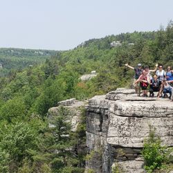
I absolutely love Storm King for hiking. It's strenuous & fulfilling to say the least. It's two small mountain humps so you have the choice of doing a shorter hike while still taking in some amazing views along the Hudson River. If you decide to do both mountains it's about a total distance of 8.5 miles total but a word of caution when you hit that second hump/mountain you WILL feel it in your legs, trust me on this. I'm a regular hiker and I still feel the burn when I hike Storm King which is why I love it so much. If you have an average hiking pace you can complete the full hike of both mountains in about 5 hours at best which is my average completion speed with a group. Solo I complete this hike in under 4 hours. Is this hike good for kids? It depends on the physical fitness level of the child you plan on taking. To give you an idea, I normally take my 9 year old daughter on this hike and she can only do one mountain so we exit our loop on the white trail. My daughter does get winded but she's completed the short loop. WARNING: If you hike this trail in the winter or freezing cold temperatures make sure you pack microspikes because on the North West side of the mountain (Stillman yellow trail) there is almost always lots & lots of ice in the winter months. I've seen people attempt to be mountain heroes and climb around the ice portion of the trails only to take dirt sample by mouth as they slide down the mountain face down desperately trying to stop there descent. Be careful in the winter months! PRINT THIS MAP: Provided by Scenic Hudson Preserves http://www.scenichudson.org/sites/default/files/stowell-webmap-rev.jpg

Highly recommend getting here early on the weekends. We arrived at 745 on a Sunday and the parking lot of a bunch of spaces available but by the time we were done at 1045 it was so packed people were waiting in a line for a spot. Make sure you go to the 9W trailhead if you want to do the loop. The very beginning of the hike was very intense. You start climbing right away. A lot of scrambles and uphills but you get to the first viewpoint fairly quickly. It's pretty but you see the parking lot and the second viewpoint is much different and worth the visit. A lot of area to sit and look out into the water. Beautiful view. I figured from that point on the trail would be downhill but we were wrong. You definitely have to push yourself in some spots. It took us about 2.5 hours with stopping. Overall it really wasn't that bad ! Worth the visit.

One of my favorite hikes in the Hudson Valley. A strenuous hike over two mountains. Hardest part is definitely the very beginning of the orange trail! Straight into a rock scramble, so be prepared. Don't let that discourage you, the money spot is so worth the hike! Be sure to bring plenty of water. It's a great challenge. Once you're at the summit you'll have a view of Breakneck Ridge, The Catskills, Stewart Airport's runway, Newburgh-Beacon Bridge, and of course the Hudson Highlands. True panoramic views. You take the orange trail & blue/green trails to the top then follow the white trail back to where you started. Bring your pup and have some lunch at the top. Enjoy the view!

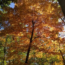
Hike took about 2 hours or so. We followed the orange markers to the blue and yellow and then finished with the white. The white markers are hard to find on the trees because they kind of blend in with it. You have to look carefully. We got somewhat lost in the middle because of the white markers, but we found our way in the end. There were several good lookout points. We came for the fall foliage but we went a week too late and the foliage was pretty much gone. The hike itself wasn't difficult but because of the all the leaves on the floor and the rain from the day before, it was a bit slippery at times. If you're done early, stop by the storm king art center closeby.
First things first, there are no real facilities at this park, just a small parking lot. Hence, parking on weekends is difficult. Arrive very early to score a spot or be prepared to wait for the parking spaces to open up. Having said that, the hike is gorgeous. We took the orange trail up, once the orange trail ended, turned RIGHT (apparently this is important to avoid getting lost) to follow the yellow/blue trail to the main view point. From there we followed the white trail to complete the loop. The hike is kind of difficult in the beginning, starting with a steep climb but the views more than make up for the effort. The main viewpoint is breathtaking. The kind of view that you can look at for hours and not get bored. The total hike is not very long and can be easily completed in 2.5-3 hours. Overall, highly recommended.

This is my new favorite hiking spot! It is a bit strenuous, but 100% worth it and you will feel amazing afterwards! The views are outstanding. I went with two of my friends, and we knew that at some point during the hike, there would be a 'money spot view.' We kept coming across a number of gorgeous views that we believed were the true 'money spot,' only to find out that they were not! You'll know you're at this view when you see the Hudson River and Newburgh-Beacon Bridge. We were a bit confused about the trail at first. You need to follow the orange marks on the trees, and then once those end, you follow the blue & yellow marks. After you reach the famous view, the blue & yellow marks end not too long after and you will follow the blue & white marks. And then, the marks turn to just white. We were curious as to why the trail was set up this way, especially since we did not see any sign explaining on the way in. But it turns out that the orange marks just mean that you are ascending, blue & yellow for views, and white marks mean you are descending. If you end up following the white marks going into the trail, you will be taking the backwards route (I think at least.. not 100% sure, this may just be a shorter hike to see the main view). This hike took us about 3.5 hours (We stopped a lot to take pictures & enjoy the scenery). Definitely bring bug/tick spray because there are some narrow un-kept paths that you have to walk through. There is a lot of climbing of rocks, but it's really not bad at all. The rocks were sturdy and we didn't have any safety issues at all! Many people also had their dogs on this trail.

This was our first visit to Storm King State Park and found it was very confusing. We got there at around 11:30 am, but the Esty and Hellie Stowell trailhead entrance wasn't clearly marked. Even though the trailhead wasn't clearly marked in the parking lot area, however, the trail inside the wood was easy to follow. We did the blue trail and then part of the yellow trail to the scenic view spot, then we came back down on the same trail. We went with three kids (10, 5 and 3), then older two were able to finish the 4 mile hike by themselves, the youngest one required a bit of assistance toward the end. The trail was not paved at all and it was bumpy and rocky. It required lots of climbing / elevating without steps. Most parts of the trail were sloped with no handrails. Some part of the trail were very narrow with slippery rocks. The view of the Hudson River was awesome when we got to the scenic view point though. It would be much easier if we did not have the little one tagged along. I would say the difficulty of this trail is moderate.

Storm King State Park is located near the town of Cornwall and a favorite park of mine in the Hudson Valley Area. Hiking trails and scenic views abound. Many of the hikes described here begin at the trailhead you park at as you travel northbound. The path I happened to take can be accessed from a small lot on the southbound side of 9W. The trails are mainly marked by colors so this particular trailhead is the white trail that connects to the blue and red. It's mainly wooded paths with a moderate grade and a running stream. It's absolutely gorgeous in the fall and a great way to get some hiking in while in, if you're in the Hudson Valley or can make it up here on a day trip I've traveled many paths here when I used to live in the area and hit upon scenic views at the top. The hike I took this week was mainly made up of meandering paths up through the woods and over foot bridges, meandering over the streams. The foliage was amazing in October and we eventually made it up to one of the reservoirs with its banks surrounded by all trees turning colors. Usually on weekends these trails are pretty well traveled but during the week, it's pretty quiet. There are maps and info panels not far in from the trailhead we took, if you're unfamiliar with the area. Get out and enjoy the beautiful Hudson Valley!

Went here with a few friends. Getting into the trail and out of the trail were the hardest parts in my opinion. The weather was beautiful and the views were gorgeous. The parking lot situation is a bit of a problem if you don't get there early enough. Luckily we didn't have a problem with that but when we were leaving there was a line of people trying to park. Overall we had a great day there. If your into hiking and sight seeing I would definitely recommend taking the trip there.

Great hiking trail only 1 hour and 6 minutes from Queens. There are a few trailheads on route 9W, 218 and Mountain Road. I started at the Mountain Road trailhead (Google "Storm King Mountain Trailhead"). There are limited parking spots, but you can park on the side of the road. You can follow the yellow trail which will branch off to the blue trail. There was a gravel trail at first for about half a mile, and after that it started to get rocky all the way to the to top. There were some great overlooks of the Hudson River along the way. It took roughly 45 minutes on the way up, but once you got to the top, it was totally worth a hike. There are several spots at the top that you can see Newburgh/Beacon or Breakneck ridge. I shoulda stayed for the sunset. Maybe next time.

Storm King Mountain is an amazing place to hike with numerous scenic overlooks of the Hudson River/Hudson Valley! Most of the overlooks are pretty roomy; great places to stop and enjoy a packed lunch. The views are plentiful and each one is gorgeous! I love that the majority of the hike was shaded (leaves still lush in the summer time) and the scenery changes as you navigate the hike -- you can see everything from more sparse forest to a lush green narrow path with moss growing and water trickling down the boulders. Some scenic points overlook the winding road or the railroad tracks, and some give you a beautiful view of the Hudson from different angles. You can even see Bannerman Island/castle from one trail. We brought our medium sized dog and he enjoyed the hike and rock scrambling as much as we did. My only complaint is that there was an absurd amount of broken glass at the beginning and end of the trail and near some overlooks... so just be cautious and make sure your furry friend doesn't get his/her paws cut up. I would highly recommend exploring Storm King! I can't wait to come back when the leaves start to change color! sidenote: We parked at the small lot that is literally right off of 9W. Came on a weekday afternoon so parking was not an issue.

Really awesome hiking trail in upstate New York!!! Only downside is the parking is VERY limited, the parking lots are small and they fill up fast, then people park on the side of the highway which is not safe. But once you get to the trail it's amazing! Blue is the most difficult, then yellow, and white is the easiest. I did the blue trail and some white, it was a little difficult with lots of inclines, declines and rocks. But wow the view at the top is just amaZing and makes it all worth it!! I highly recommend and it's fairly easy to follow the trail, there are markers along trees guiding you in the right direction. Enjoy it's a great one!!

2 years ago
We have been here many time to hike with our dogs over the last few years. Great views of the Hudson River and surrounding area from the North Point/ Pitching Point Loop Trail. We always get there early (7 AM) because the lot for North Point/ Pitching Point Loop is super small. Great hike with great views ! read more


3 years ago
Are these views to die for? Highly debatable. We came after a day where it rained the night before in the late fall. There's some really cool views of what appears to be a lake, but it could also be the Hudson River. I am not sure because I had no signal at this park. When I said are the views to die for, I mean some of our hiking crew probably would have died if we weren't paying attention. There's a lot of trails that are especially narrow, on a cliff's edge, and the leaves are super slippery. Should be warning signs like die at your own risk or something. There are certain paths with wooden bridges and guard rails, but they are not frequent. If you are planning to have a picnic here, I'd suggest going to a local park instead. The only benches are at the parking lot, and there are no bathrooms... Unless you count mother nature as a bathroom. read more


Great hiking and great views. Only about 3 miles each way. Can get a bit steep at times. We did have to get on all fours a couple times, in order to climb up. We went first thing in the morning on a Wednesday. Got there about 9:00. Parking lot had maybe 5 cars. By the time we got back to the lot, about noon, there were maybe 10 cars. The lot has a capacity of about 30 cars? So, definitely go during the weekdays. We only passed 3 groups while hiking. And most of that time was spent in shade, an added bonus on a hot day. And it's free. What's not to love? Come enjoy one of the area's best views. read more


6 years ago
Nice easy hike with some elevation weaving in and out through the woods to give you a break from the sun! Rewarded with awesome views of the Hudson River and views of the mountains as your backdrop. My 1st time in this area so I'm not too familiar with the sites but just know it's breathtaking! There is a parking lot right off Rt 9. Came on a Wednesday and arrived at noon right after the rain stopped... so super lucky there was barely anyone here. But I heard weekends (especially during Covid times) has been a nightmare with parking. Lots of NO PARKING signs on the shoulder, so maybe lots of people were using the shoulder to park. Anyways... go during off peak times and you should be good with parking. Started the trail at the Orange Trail and just followed the blazes. Eventually it turned Yellow Blue before getting the awesome views. Then routed it as a loop and continued the Yellow Blue Trail til we saw the White blazes and that lead us back to the parking for a nice easy loop. I've seen some rate this as moderate and needed to use all fours to climb. They must not have followed a trail because unless you do want to make it harder, you can. But you just have to look around and pick your steps wisely because I'm short (4'11) and stepped up pretty easily without needing to use my hands. Now there is some elevation, but it isn't a constant elevation and you get a break with flat trails through the woods. If you've never hiked in nature before, then maybe this is a little more strenuous... but my rating is that it's pretty easy! There are some trees down along the trails but don't sweat, just take your time, look for the blazes ahead and go around the downed trees. Of course with any hike, do your research, prepare and enjoy nature! read more


I absolutely love Storm King for hiking. It's strenuous & fulfilling to say the least. It's two small mountain humps so you have the choice of doing a shorter hike while still taking in some amazing views along the Hudson River. If you decide to do both mountains it's about a total distance of 8.5 miles total but a word of caution when you hit that second hump/mountain you WILL feel it in your legs, trust me on this. I'm a regular hiker and I still feel the burn when I hike Storm King which is why I love it so much. If you have an average hiking pace you can complete the full hike of both mountains in about 5 hours at best which is my average completion speed with a group. Solo I complete this hike in under 4 hours. Is this hike good for kids? It depends on the physical fitness level of the child you plan on taking. To give you an idea, I normally take my 9 year old daughter on this hike and she can only do one mountain so we exit our loop on the white trail. My daughter does get winded but she's completed the short loop. WARNING: If you hike this trail in the winter or freezing cold temperatures make sure you pack microspikes because on the North West side of the mountain (Stillman yellow trail) there is almost always lots & lots of ice in the winter months. I've seen people attempt to be mountain heroes and climb around the ice portion of the trails only to take dirt sample by mouth as they slide down the mountain face down desperately trying to stop there descent. Be careful in the winter months! PRINT THIS MAP: Provided by Scenic Hudson Preserves http://www.scenichudson.org/sites/default/files/stowell-webmap-rev.jpg read more

Highly recommend getting here early on the weekends. We arrived at 745 on a Sunday and the parking lot of a bunch of spaces available but by the time we were done at 1045 it was so packed people were waiting in a line for a spot. Make sure you go to the 9W trailhead if you want to do the loop. The very beginning of the hike was very intense. You start climbing right away. A lot of scrambles and uphills but you get to the first viewpoint fairly quickly. It's pretty but you see the parking lot and the second viewpoint is much different and worth the visit. A lot of area to sit and look out into the water. Beautiful view. I figured from that point on the trail would be downhill but we were wrong. You definitely have to push yourself in some spots. It took us about 2.5 hours with stopping. Overall it really wasn't that bad ! Worth the visit. read more


One of my favorite hikes in the Hudson Valley. A strenuous hike over two mountains. Hardest part is definitely the very beginning of the orange trail! Straight into a rock scramble, so be prepared. Don't let that discourage you, the money spot is so worth the hike! Be sure to bring plenty of water. It's a great challenge. Once you're at the summit you'll have a view of Breakneck Ridge, The Catskills, Stewart Airport's runway, Newburgh-Beacon Bridge, and of course the Hudson Highlands. True panoramic views. You take the orange trail & blue/green trails to the top then follow the white trail back to where you started. Bring your pup and have some lunch at the top. Enjoy the view! read more


Hike took about 2 hours or so. We followed the orange markers to the blue and yellow and then finished with the white. The white markers are hard to find on the trees because they kind of blend in with it. You have to look carefully. We got somewhat lost in the middle because of the white markers, but we found our way in the end. There were several good lookout points. We came for the fall foliage but we went a week too late and the foliage was pretty much gone. The hike itself wasn't difficult but because of the all the leaves on the floor and the rain from the day before, it was a bit slippery at times. If you're done early, stop by the storm king art center closeby. read more


6 years ago
First things first, there are no real facilities at this park, just a small parking lot. Hence, parking on weekends is difficult. Arrive very early to score a spot or be prepared to wait for the parking spaces to open up. Having said that, the hike is gorgeous. We took the orange trail up, once the orange trail ended, turned RIGHT (apparently this is important to avoid getting lost) to follow the yellow/blue trail to the main view point. From there we followed the white trail to complete the loop. The hike is kind of difficult in the beginning, starting with a steep climb but the views more than make up for the effort. The main viewpoint is breathtaking. The kind of view that you can look at for hours and not get bored. The total hike is not very long and can be easily completed in 2.5-3 hours. Overall, highly recommended. read more


This is my new favorite hiking spot! It is a bit strenuous, but 100% worth it and you will feel amazing afterwards! The views are outstanding. I went with two of my friends, and we knew that at some point during the hike, there would be a 'money spot view.' We kept coming across a number of gorgeous views that we believed were the true 'money spot,' only to find out that they were not! You'll know you're at this view when you see the Hudson River and Newburgh-Beacon Bridge. We were a bit confused about the trail at first. You need to follow the orange marks on the trees, and then once those end, you follow the blue & yellow marks. After you reach the famous view, the blue & yellow marks end not too long after and you will follow the blue & white marks. And then, the marks turn to just white. We were curious as to why the trail was set up this way, especially since we did not see any sign explaining on the way in. But it turns out that the orange marks just mean that you are ascending, blue & yellow for views, and white marks mean you are descending. If you end up following the white marks going into the trail, you will be taking the backwards route (I think at least.. not 100% sure, this may just be a shorter hike to see the main view). This hike took us about 3.5 hours (We stopped a lot to take pictures & enjoy the scenery). Definitely bring bug/tick spray because there are some narrow un-kept paths that you have to walk through. There is a lot of climbing of rocks, but it's really not bad at all. The rocks were sturdy and we didn't have any safety issues at all! Many people also had their dogs on this trail. read more

5 years ago
This was our first visit to Storm King State Park and found it was very confusing. We got there at around 11:30 am, but the Esty and Hellie Stowell trailhead entrance wasn't clearly marked. Even though the trailhead wasn't clearly marked in the parking lot area, however, the trail inside the wood was easy to follow. We did the blue trail and then part of the yellow trail to the scenic view spot, then we came back down on the same trail. We went with three kids (10, 5 and 3), then older two were able to finish the 4 mile hike by themselves, the youngest one required a bit of assistance toward the end. The trail was not paved at all and it was bumpy and rocky. It required lots of climbing / elevating without steps. Most parts of the trail were sloped with no handrails. Some part of the trail were very narrow with slippery rocks. The view of the Hudson River was awesome when we got to the scenic view point though. It would be much easier if we did not have the little one tagged along. I would say the difficulty of this trail is moderate. read more


9 years ago
Storm King State Park is located near the town of Cornwall and a favorite park of mine in the Hudson Valley Area. Hiking trails and scenic views abound. Many of the hikes described here begin at the trailhead you park at as you travel northbound. The path I happened to take can be accessed from a small lot on the southbound side of 9W. The trails are mainly marked by colors so this particular trailhead is the white trail that connects to the blue and red. It's mainly wooded paths with a moderate grade and a running stream. It's absolutely gorgeous in the fall and a great way to get some hiking in while in, if you're in the Hudson Valley or can make it up here on a day trip I've traveled many paths here when I used to live in the area and hit upon scenic views at the top. The hike I took this week was mainly made up of meandering paths up through the woods and over foot bridges, meandering over the streams. The foliage was amazing in October and we eventually made it up to one of the reservoirs with its banks surrounded by all trees turning colors. Usually on weekends these trails are pretty well traveled but during the week, it's pretty quiet. There are maps and info panels not far in from the trailhead we took, if you're unfamiliar with the area. Get out and enjoy the beautiful Hudson Valley! read more


Went here with a few friends. Getting into the trail and out of the trail were the hardest parts in my opinion. The weather was beautiful and the views were gorgeous. The parking lot situation is a bit of a problem if you don't get there early enough. Luckily we didn't have a problem with that but when we were leaving there was a line of people trying to park. Overall we had a great day there. If your into hiking and sight seeing I would definitely recommend taking the trip there. read more

10 years ago
Great hiking trail only 1 hour and 6 minutes from Queens. There are a few trailheads on route 9W, 218 and Mountain Road. I started at the Mountain Road trailhead (Google "Storm King Mountain Trailhead"). There are limited parking spots, but you can park on the side of the road. You can follow the yellow trail which will branch off to the blue trail. There was a gravel trail at first for about half a mile, and after that it started to get rocky all the way to the to top. There were some great overlooks of the Hudson River along the way. It took roughly 45 minutes on the way up, but once you got to the top, it was totally worth a hike. There are several spots at the top that you can see Newburgh/Beacon or Breakneck ridge. I shoulda stayed for the sunset. Maybe next time. read more


8 years ago
Storm King Mountain is an amazing place to hike with numerous scenic overlooks of the Hudson River/Hudson Valley! Most of the overlooks are pretty roomy; great places to stop and enjoy a packed lunch. The views are plentiful and each one is gorgeous! I love that the majority of the hike was shaded (leaves still lush in the summer time) and the scenery changes as you navigate the hike -- you can see everything from more sparse forest to a lush green narrow path with moss growing and water trickling down the boulders. Some scenic points overlook the winding road or the railroad tracks, and some give you a beautiful view of the Hudson from different angles. You can even see Bannerman Island/castle from one trail. We brought our medium sized dog and he enjoyed the hike and rock scrambling as much as we did. My only complaint is that there was an absurd amount of broken glass at the beginning and end of the trail and near some overlooks... so just be cautious and make sure your furry friend doesn't get his/her paws cut up. I would highly recommend exploring Storm King! I can't wait to come back when the leaves start to change color! sidenote: We parked at the small lot that is literally right off of 9W. Came on a weekday afternoon so parking was not an issue. read more


4 years ago
Really awesome hiking trail in upstate New York!!! Only downside is the parking is VERY limited, the parking lots are small and they fill up fast, then people park on the side of the highway which is not safe. But once you get to the trail it's amazing! Blue is the most difficult, then yellow, and white is the easiest. I did the blue trail and some white, it was a little difficult with lots of inclines, declines and rocks. But wow the view at the top is just amaZing and makes it all worth it!! I highly recommend and it's fairly easy to follow the trail, there are markers along trees guiding you in the right direction. Enjoy it's a great one!! read more


8 years ago
Really awesome hike with beautiful views, but definitely easy to get lost on! I follow hike the Hudson valley and still got lost. The money spot is identified by a National Geographic deal, but you have to sort of walk around to get to the real money spot. In doing this walk, we got terribly lost even though we were on the right color path. Eventually my boyfriend gpsed the car and we walked to it. This is a fairly tough hike. It's a pretty steady climb for a good 40 minutes. It's not nearly as strenuous as Breakneck, but it's definitely a good workout. The views are also pretty impressive. read more


An amazing, scenic hike. We were looking for a mildly long hike but nothing that would really tire us out. This hike was perfect. The first 30 minutes or so are straight up hill but everything else is pretty flat. The hike took about 2.5 hours to complete and had so many lovely spots to stop and take a breather or some pictures! I would definitely do this hike again, it was that lovely! The trail markers are very clear, just be sure to keep track of the trail you have decided to follow. Many people were also doing this hike with kids and their dogs! read more

13 years ago
12 years ago
Amazing place. 1) This mountain has multiple views. 2) Use the orange (but looks red to me) to ascend up. 3) Then use the blue and yellow trail for the overlooks. 4) To come down, use the white trail. Enjoy. read more


What a great work-out this was! We covered a distance of approximately 4 miles in 3 hrs, roughly 1300ft elevation gain. The trail starts ascending as you leave the parking lot. There are a couple of spots where you need to scramble over rocks, and some spots where you're walking along the edge of the mountain. A good spot to break for lunch is an open spot with view of Breakneck Ridge. Another good spot is an area further on with view of the Bannerman's Island. This would be a good hike for intermediate hikers. I would say beginners can do the hike as well, but you need to be in somewhat good shape because of all the scrambling & elevation. There are no rest-rooms or visitor center at the parking lot. The parking lot is the one with the marker about "Freedom Road". The trail was well-marked, but you definitely need a map since a couple of different trails mark the area. For reference, see the NY-NJTC West Hudson Trails Map#113. read more


8 years ago
6 years ago
9 years ago
Challenging hike. Worth it. Bring water. Water good shoes for hiking. Very very challenging for beginners. Going up and coming down. Worth it. What a view. Good way for excercise. read more

Great hiking! I've done the butterhill/stillman/bluebird loop, as well as the butterhill/stillman/bypass loop. Both were great, but the second was the perfect amount of time for a little day trip and picnic at the top of the summit. A bit of climbing right in the beginning and a few assents and descents throughout. I'd rate it at the more difficult end of intermediate for more inexperienced hikers but definitely doable for all skill levels. Be careful of your footing, it can be quite rocky and slippery in some areas. read more

Legend has it that Storm King Mountain was given its name after its ability to conjure tempests. But we were lucky on our day of hiking in November and greeted with perfect fall weather, although we unfortunately missed the fall leaves. The mountain is located ~1.5 hrs from Long Island, right next to Westpoint and worthy of the commute! We were pleased with the beautiful panoramas of the Hudson and moderately strenuous but doable trails. We took the Butter Hill and ?Blue bird- we went off trail, had a long lunch, and proceeded to get lost and took 3.5 hours. If you went straight through can probably taken 2-2.5 hrs, especially if you are somewhat in shape. Make time after or before your hike for the Storm King Art sculpture park which is only a couple minutes drive away! read more

8 years ago
12 years ago
9 years ago
More info about Storm King State Park
US 9W
Cornwall-on-Hudson, NY 12520
Directions
Visit Website
http://www.nycdayhiking.com/hikes/strmking.htm
Hours
Indoor Amenities
Outdoor Amenities
Ask the Community - Storm King State Park
Review Highlights - Storm King State Park


Why does Yelp recommend reviews?
Storm King State Park - hiking - Updated July 2026
Best of Cornwall-on-Hudson
People found Storm King State Park by searching for…
Parks in Cornwall-on-Hudson, NY
Scenic Overlook in Cornwall-on-Hudson, NY
Hiking Trails in Cornwall-on-Hudson, NY
Scenic View in Cornwall-on-Hudson, NY
Fun Things to Do in Cornwall-on-Hudson, NY
Running Trails in Cornwall-on-Hudson, NY
Walking Trails in Cornwall-on-Hudson, NY
Playgrounds in Cornwall-on-Hudson, NY
Scenic Drive in Cornwall-on-Hudson, NY
Dog Friendly Parks in Cornwall-on-Hudson, NY
View Points in Cornwall-on-Hudson, NY
Sunset View in Cornwall-on-Hudson, NY
Waterfall Hike in Cornwall-on-Hudson, NY
Picnic Areas in Cornwall-on-Hudson, NY
Parks for Kids in Cornwall-on-Hudson, NY
Picnic Spots in Cornwall-on-Hudson, NY
Lookout Points in Cornwall-on-Hudson, NY
Dog Friendly Hiking Trails in Cornwall-on-Hudson, NY
Day Trips in Cornwall-on-Hudson, NY
Fishing Spots in Cornwall-on-Hudson, NY
Easy Hikes in Cornwall-on-Hudson, NY
Hiking With Kids in Cornwall-on-Hudson, NY
Trending Searches in Cornwall-on-Hudson, NY
Black Owned Nail Salons in Cornwall-on-Hudson, NY
Blueberry Picking in Cornwall-on-Hudson, NY
Boat Rental in Cornwall-on-Hudson, NY
Cliff Jumping in Cornwall-on-Hudson, NY
Day Trips in Cornwall-on-Hudson, NY
Jet Ski Rental in Cornwall-on-Hudson, NY
Kayak Rental in Cornwall-on-Hudson, NY
Lakes & Ponds in Cornwall-on-Hudson, NY
Off Road Trails in Cornwall-on-Hudson, NY
Outdoor Activities in Cornwall-on-Hudson, NY
Picnic Spots in Cornwall-on-Hudson, NY
Public Pools in Cornwall-on-Hudson, NY
Public Shower in Cornwall-on-Hudson, NY
River Swimming in Cornwall-on-Hudson, NY
River Tubing in Cornwall-on-Hudson, NY
Running Trails in Cornwall-on-Hudson, NY
Scenic Overlook in Cornwall-on-Hudson, NY
Splash Pad in Cornwall-on-Hudson, NY
Swimming Holes in Cornwall-on-Hudson, NY
Swimming Lakes in Cornwall-on-Hudson, NY
U Pick Farms in Cornwall-on-Hudson, NY
Browse Articles
Browse Nearby
BEST of Cornwall-on-Hudson, New York Things to Do near Storm King State Park
BEST of Cornwall-on-Hudson, New York Restaurants near Storm King State Park
BEST of Cornwall-on-Hudson, New York Coffee near Storm King State Park
BEST of Cornwall-on-Hudson, New York Walking Trails near Storm King State Park
BEST of Cornwall-on-Hudson, New York Breakfast near Storm King State Park
BEST of Cornwall-on-Hudson, New York Parks near Storm King State Park
BEST of Cornwall-on-Hudson, New York Campgrounds near Storm King State Park
BEST of Cornwall-on-Hudson, New York Sledding near Storm King State Park
BEST of Cornwall-on-Hudson, New York Day Trips near Storm King State Park
Browse Brands
Related Searches in Cornwall-on-Hudson, NY
Affordable Kayak Rental Services in Cornwall-on-Hudson, New York
Best Fishing Locations and Guides in Cornwall-on-Hudson, New York
Best Fun Things to Do in Cornwall-on-Hudson, New York
Best Places for Horseback Riding in Cornwall-on-Hudson, New York
Discover Dog Friendly Trails to Explore in Cornwall-on-Hudson, New York
Discover Lakes & Ponds to Explore in Cornwall-on-Hudson, New York
Discover Top Boat Tours in Cornwall-on-Hudson, New York for All Ages
Discover a Hiking Trail in Cornwall-on-Hudson, New York
Discover the Best Night Hike Trails in Cornwall-on-Hudson, New York
Dog-Friendly Hikes With Dogs in Cornwall-on-Hudson, New York
Enjoy Exciting Mountain Biking Adventures in Cornwall-on-Hudson, New York
Enjoy a Beautiful Waterfall Hike in Cornwall-on-Hudson, New York
Enjoy the Best Tubing Experiences in Cornwall-on-Hudson, New York
Enjoy the Best Walking Trails in Cornwall-on-Hudson, New York
Exciting Cliff Jumping Spots in Cornwall-on-Hudson, New York
Explore Beautiful Parks and Green Spaces in Cornwall-on-Hudson, New York
Explore Bike Rentals Throughout Cornwall-on-Hudson, New York
Explore Easy Hikes Perfect for All in Cornwall-on-Hudson, New York
Explore Family-Friendly Zoos and Wildlife in Cornwall-on-Hudson, New York
Explore Free Things to Do Around Cornwall-on-Hudson, New York
Explore Fun Activities to Do in Cornwall-on-Hudson, New York
Explore Popular Campgrounds Near Cornwall-on-Hudson, New York
Explore Popular RV Parks Around Cornwall-on-Hudson, New York
Explore Scenic Lakes to Visit in Cornwall-on-Hudson, New York
Explore Top Dog Parks in Cornwall-on-Hudson, New York Near You
Explore Top Water Parks in Cornwall-on-Hudson, New York Today
Explore the Best Boating Spots in Cornwall-on-Hudson, New York
Explore the Best Swimming Holes Around Cornwall-on-Hudson, New York
Family Friendly Hiking With Kids in Cornwall-on-Hudson, New York
Find Popular Ziplining Spots Around Cornwall-on-Hudson, New York
Find the Best Playgrounds to Visit in Cornwall-on-Hudson, New York
Find the Best Scenic View Locations in Cornwall-on-Hudson, New York
Find the Best Swimming Pools in Cornwall-on-Hudson, New York Today
Have Fun at a Splash Pad in Cornwall-on-Hudson, New York
Hiking Trails With Waterfalls in Cornwall-on-Hudson, New York
Must-See Tourist Attractions Around Cornwall-on-Hudson, New York
Off Leash Dog Hiking Trails in Cornwall-on-Hudson, New York
Perfect Spots to Watch Sunset in Cornwall-on-Hudson, New York
Popular Fishing Spots to Explore in Cornwall-on-Hudson, New York
Popular Kids Activities in Cornwall-on-Hudson, New York
Popular Outdoor Activities to Try in Cornwall-on-Hudson, New York
Popular Picnic Spots to Visit in Cornwall-on-Hudson, New York
Popular Places to Take Pictures in Cornwall-on-Hudson, New York
Popular Things to Do in Cornwall-on-Hudson, New York
Top Paddleboarding Activities in Cornwall-on-Hudson, New York
Top Running Trails to Explore in Cornwall-on-Hudson, New York
Top Swimming Lakes to Enjoy in Cornwall-on-Hudson, New York
Top Swimming Spots and Pools in Cornwall-on-Hudson, New York
Top Things to Do With Kids in Cornwall-on-Hudson, New York
Walk Dog Friendly Hiking Trails in Cornwall-on-Hudson, New York