Slate Canyon Park Photos


You might also consider
More like Slate Canyon Park
Recommended Reviews - Slate Canyon Park
Start your review...

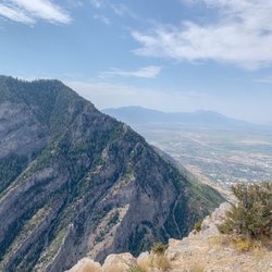
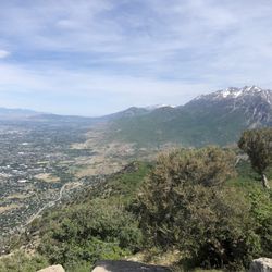
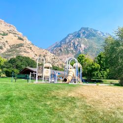
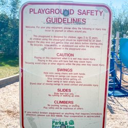
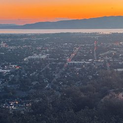
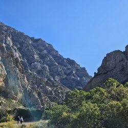
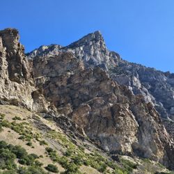
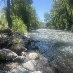
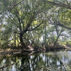
Very easy access from the 15! Parking spots are easy and provide quick access to all the trails. There seems to be a lot to offer depending on what you want to do. You will see mountain bikers, runners, and hikers in this area. If you're looking for something chill, try out the short trails leading to some nice vantage points. For the more adventurous, take a deep hike into the valley and enjoy the lush landscape. Also very family friendly and dog friendly. Only wished there was more signage to help us navigate the web of trails. Update: We were able to hike part of the Slate Canyon trail yesterday. It is an 8.5 mi. loop, considered a "difficult" rating. Due to time constraints we were only able to check out about a quarter of it. Very beautiful view of the cliffs on the trail, and excellent resting spots with good shade. Very family friendly, with some flat parts of the trail and nice climbing as well. Carrier recommended for toddlers. read more
 - Hiking Near Me - Provo, Utah")
More info about Slate Canyon Park
660 S Slate Canyon Dr
Provo, UT 84606
Directions
Hours
Outdoor Amenities


Slate Canyon Park - hiking - Updated July 2026
Best of Provo
People found Slate Canyon Park by searching for…
Trending Searches in Provo, UT
Browse Articles
Browse Nearby
BEST of Provo, Utah Coffee near Slate Canyon Park
BEST of Provo, Utah Things to Do near Slate Canyon Park
BEST of Provo, Utah Restaurants near Slate Canyon Park
BEST of Provo, Utah Walking Trails near Slate Canyon Park
BEST of Provo, Utah Parks near Slate Canyon Park
BEST of Provo, Utah Hot Springs near Slate Canyon Park
BEST of Provo, Utah Breakfast near Slate Canyon Park
Browse Brands
Related Searches in Provo, UT
Affordable Kayak Rental Services in Provo, Utah
Best Fishing Locations and Guides in Provo, Utah
Best Places for Horseback Riding in Provo, Utah
Check Out Off Road Trails in Provo, Utah
Discover Dog Friendly Trails to Explore in Provo, Utah
Discover Scenic Mountain Bike Trails Near Provo, Utah
Discover a Hiking Trail in Provo, Utah
Discover the Best Night Hike Trails in Provo, Utah
Dog-Friendly Hikes With Dogs in Provo, Utah
Enjoy Camping Adventures Around Provo, Utah
Enjoy Exciting Mountain Biking Adventures in Provo, Utah
Enjoy Kayaking Adventures in Provo, Utah
Enjoy River Tubing Adventures in Provo, Utah
Enjoy Tent Camping Spots Around Provo, Utah
Enjoy a Beautiful Waterfall Hike in Provo, Utah
Enjoy the Best Walking Trails in Provo, Utah
Exciting Cliff Jumping Spots in Provo, Utah
Experience Thrilling White Water Rafting in Provo, Utah
Explore Beautiful Parks and Green Spaces in Provo, Utah
Explore Bike Rentals Throughout Provo, Utah
Explore Easy Hikes Perfect for All in Provo, Utah
Explore Fun Activities to Do in Provo, Utah
Explore Popular Campgrounds Near Provo, Utah
Explore Popular RV Parks Around Provo, Utah
Explore Scenic Lakes to Visit in Provo, Utah
Explore the Best Boating Spots in Provo, Utah
Explore the Best Swimming Holes Around Provo, Utah
Family Friendly Hiking With Kids in Provo, Utah
Find Beautiful Views in Provo, Utah
Find Parks and Recreation Activities in Provo, Utah
Find Popular Ziplining Spots Around Provo, Utah
Find the Best Parks for Picnics in Provo, Utah
Find the Best Playgrounds to Visit in Provo, Utah
Find the Best Scenic View Locations in Provo, Utah
Hiking Trails With Waterfalls in Provo, Utah
Off Leash Dog Hiking Trails in Provo, Utah
Picnic Areas With BBQ Pits Available in Provo, Utah
Plan a Scenic Drive Route Near Provo, Utah
Popular Fishing Spots to Explore in Provo, Utah
Popular Outdoor Activities to Try in Provo, Utah
Popular Picnic Spots to Visit in Provo, Utah
Safe River Swimming Areas in Provo, Utah
Safe and Fun Parks for Kids in Provo, Utah
Top Climbing Spots and Gyms in Provo, Utah
Top Playgrounds for Kids to Enjoy in Provo, Utah
Top Running Trails to Explore in Provo, Utah
Top Swimming Lakes to Enjoy in Provo, Utah
Top Swimming Spots and Pools in Provo, Utah
People who viewed Slate Canyon Park also viewed
Provo Canyon Recreation Trail
8 reviews
Big Springs Park
4 reviews
Spanish Fork River Trail
5 reviews
Squaw Peak Trail
2 reviews
Hobble Creek Trail
1 review
Dripping Rock Falls
1 review
Dry Canyon Trail Head
3 reviews
Stewart Falls Trailhead
24 reviews
Scout Falls via Mount Timpanogos Trail
2 reviews
Deer Creek State Park
20 reviews