
Jordan River Trail Photos


You might also consider
More like Jordan River Trail
Recommended Reviews - Jordan River Trail
Start your review...

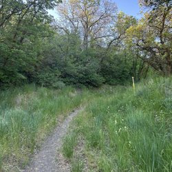
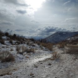
This is a beautiful trail along the Jordan River. It's one of my favorite walks with beautiful scenery and connects to paths in my neighborhood Bikers, runners, and walkers alike use it. There are mile markers along the way. read more


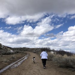
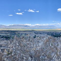
I discovered this entrance when I began running from Thanksgiving point and headed south. I happened to run alongside the trail and Olympic Park in Lehi. If you are seeking an easy access point with good parking, I recommend Olympic Park in Lehi. You can access the trail and go left or right depending on your mood by simply walking to the back of the park. The views in either direction are great and the path is paved, so it makes for an easy stroll, jog, or bike ride with the family. Lastly, we found it to be safe, not over crowded, and easily accessible. read more


More info about Jordan River Trail
Lehi, UT 84043
Directions
Hours
Outdoor Amenities


Jordan River Trail - hiking - Updated July 2026
Best of Lehi
People found Jordan River Trail by searching for…
Trending Searches in Lehi, UT
Boat Tours near Jordan River Trail
Cliff Jumping near Jordan River Trail
Day Trips near Jordan River Trail
Dog Friendly Things To Do near Jordan River Trail
Jet Ski Rental near Jordan River Trail
Kayak Rental near Jordan River Trail
Kids Activities Indoor near Jordan River Trail
Off Road Trails near Jordan River Trail
Outdoor Activities near Jordan River Trail
Picnic near Jordan River Trail
Public Shower near Jordan River Trail
Rainy Day Activities near Jordan River Trail
River Swimming near Jordan River Trail
Rock Quarry near Jordan River Trail
Scenic Night View near Jordan River Trail
Scenic Overlook near Jordan River Trail
State Parks near Jordan River Trail
Surf Shop near Jordan River Trail
Swimming Holes near Jordan River Trail
Swimming Lakes near Jordan River Trail
Things To Do On A Rainy Day near Jordan River Trail
Tubing near Jordan River Trail
U Pick Farms near Jordan River Trail
View Points near Jordan River Trail
Watch Sunset near Jordan River Trail
Browse Articles
Browse Nearby
BEST of Lehi, Utah Coffee near Jordan River Trail
BEST of Lehi, Utah Restaurants near Jordan River Trail
BEST of Lehi, Utah Things to Do near Jordan River Trail
BEST of Lehi, Utah Breakfast near Jordan River Trail
BEST of Lehi, Utah Parks near Jordan River Trail
Browse Brands
Related Searches in Lehi, UT
Affordable Kayak Rental Services in Lehi, Utah
Best Dog Hiking Trails Around Lehi, Utah
Best Fishing Locations and Guides in Lehi, Utah
Best Places for Horseback Riding in Lehi, Utah
Best Sightseeing Experiences Available in Lehi, Utah
Check Out Off Road Trails in Lehi, Utah
Discover Dog Friendly Trails to Explore in Lehi, Utah
Discover Popular Bike Trails in Lehi, Utah
Discover Scenic Mountain Bike Trails Near Lehi, Utah
Discover a Hiking Trail in Lehi, Utah
Discover the Best Night Hike Trails in Lehi, Utah
Dog-Friendly Hikes With Dogs in Lehi, Utah
Enjoy Camping Adventures Around Lehi, Utah
Enjoy Kayaking Adventures in Lehi, Utah
Enjoy Off Leash Dog Hikes in Lehi, Utah
Enjoy Scenic Places to Walk in Lehi, Utah
Enjoy Tent Camping Spots Around Lehi, Utah
Enjoy a Beautiful Waterfall Hike in Lehi, Utah
Enjoy the Best Picnic Spots and Ideas in Lehi, Utah
Enjoy the Best Walking Path in Lehi, Utah
Enjoy the Best Walking Trails in Lehi, Utah
Explore Beautiful Parks and Green Spaces in Lehi, Utah
Explore Easy Hikes Perfect for All in Lehi, Utah
Explore Fun Activities to Do in Lehi, Utah
Explore Popular Campgrounds Near Lehi, Utah
Explore Top Dog Parks in Lehi, Utah Near You
Explore the Best Beach Spots in Lehi, Utah
Family Friendly Hiking With Kids in Lehi, Utah
Find Cozy Camping Cabins in Lehi, Utah
Find Parks and Recreation Activities in Lehi, Utah
Find Popular Ziplining Spots Around Lehi, Utah
Find Top-Rated Waterfalls in Lehi, Utah Now
Find the Best Parks for Picnics in Lehi, Utah
Find the Best Playgrounds to Visit in Lehi, Utah
Hiking Trails With Waterfalls in Lehi, Utah
Off Leash Dog Hiking Trails in Lehi, Utah
Plan a Scenic Drive Route Near Lehi, Utah
Popular Outdoor Activities to Try in Lehi, Utah
Popular Picnic Spots to Visit in Lehi, Utah
Safe River Swimming Areas in Lehi, Utah
Safe and Fun Parks for Kids in Lehi, Utah
Top Hiking Trails to Explore in Lehi, Utah
Top Playgrounds for Kids to Enjoy in Lehi, Utah
Top Running Trails to Explore in Lehi, Utah
Top Swimming Lakes to Enjoy in Lehi, Utah
Top Swimming Spots and Pools in Lehi, Utah
Top Things to Do With Kids in Lehi, Utah
People who viewed Jordan River Trail also viewed
Battle Creek Falls Trail
11 reviews
Bear Canyon Suspension Bridge Trail
18 reviews
Creekview Hiking Trail
1 review
Sego Lily Trail
1 review
Carolina Hills Trail Head
1 review
Bonneville Shoreline Trail
1 review
Cascade Springs
9 reviews
Temple Quarry Trailhead
3 reviews
Bell Canyon
43 reviews
Golden Eagle Pass
1 review