Gloria Falls Photos


 - Hiking Near Me")
You might also consider
More like Gloria Falls
Recommended Reviews - Gloria Falls
Start your review...

Reviews With Photos

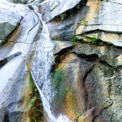
Gloria Falls is a great, family-friendly hike in Little Cottonwood Canyon. We have hiked to Gloria Falls many times and enjoyed our time in the Wasatch Mountains. The waterfall was super spectacular this spring and summer after the record snowfalls in the winter. Gloria Falls is also a fun snowshoeing hike in the winter for the more adventurous.

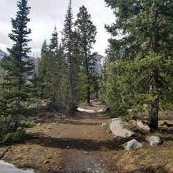
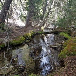
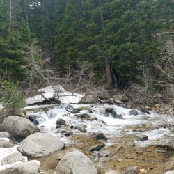
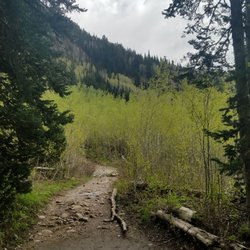
Gloria Falls is a family-friendly trail in Little Cottonwood Canyon up to a beautiful waterfall. The hike is 2.3 miles, and is shady, rocky and well-traveled. Start out at the White Pine/Red Pine trailhead. Trail will split about a mile and half up the trail. Stay to the left and follow the river up to the falls. Quite impressive and fun for the kids. No dogs are allowed in canyon due to watershed.

1 year ago
2.75 miles total to the falls and back! Had a little more incline than I was expecting but would say this is overall a "moderate" hike! Around 595 ft. elevation gain throughout the hike :) The falls were stunning! We went in the afternoon and there were a lot of families on the trail but not too overly crowded. read more


This review is for Gloria Falls which was a ~2.2 miles round trip that took ~1.5 hours to complete. Another crowded trail; small parking lot with parking available on the side of the highway. Steady incline to the waterfall with a slight detour to the river otherwise follow the pink ribbons. Amazing views of Gloria Falls at the end! Short video of the hike for those interested! https://youtu.be/zPyHcMDeuGo read more


Gloria Falls is a great, family-friendly hike in Little Cottonwood Canyon. We have hiked to Gloria Falls many times and enjoyed our time in the Wasatch Mountains. The waterfall was super spectacular this spring and summer after the record snowfalls in the winter. Gloria Falls is also a fun snowshoeing hike in the winter for the more adventurous. read more


Gloria Falls is a family-friendly trail in Little Cottonwood Canyon up to a beautiful waterfall. The hike is 2.3 miles, and is shady, rocky and well-traveled. Start out at the White Pine/Red Pine trailhead. Trail will split about a mile and half up the trail. Stay to the left and follow the river up to the falls. Quite impressive and fun for the kids. No dogs are allowed in canyon due to watershed. read more


Easy hike up amd back about 2.6 miles total. Th trail runs along the side of the river most the way. There were lots of small kids hiking, so it's pretty kid friendly. The water is fridged cold, but some people got all wet in it. Most were putting their feet in it. It was about 95 degrees heat when we did the hike, but still didn't jump in. read more


More info about Gloria Falls
Alta, UT 84092
Directions
Hours
Indoor Amenities
Outdoor Amenities
Ask the Community - Gloria Falls
You might also consider


Gloria Falls - hiking - Updated June 2026
Best of Alta
People found Gloria Falls by searching for…
Trending Searches in Alta, UT
Bait And Tackle Shop near Gloria Falls
Bird Sanctuary near Gloria Falls
Cliff Jumping near Gloria Falls
Fishing Spots near Gloria Falls
Free Kids Activities near Gloria Falls
Jet Ski Rental near Gloria Falls
Kayak Rental near Gloria Falls
Lakes & Ponds near Gloria Falls
Off Road Trails near Gloria Falls
Outdoor Activities near Gloria Falls
Pick Your Own Farms near Gloria Falls
Public Shower near Gloria Falls
Scenic Drive near Gloria Falls
Scenic Night View near Gloria Falls
Secluded Spots near Gloria Falls
Soccer Store near Gloria Falls
Strawberry Picking near Gloria Falls
Sunrise View near Gloria Falls
Swimming Holes near Gloria Falls
Swimming Lakes near Gloria Falls
Swimming Pools near Gloria Falls
Browse Articles
Browse Nearby
BEST of Alta, Utah Restaurants near Gloria Falls
BEST of Alta, Utah Things to Do near Gloria Falls
BEST of Alta, Utah Coffee near Gloria Falls
BEST of Alta, Utah Parks near Gloria Falls
BEST of Alta, Utah Breakfast near Gloria Falls
BEST of Alta, Utah Fishing near Gloria Falls
Browse Brands
Related Searches in Alta, UT
Affordable Kayak Rental Services in Alta, Utah
Best Fishing Locations and Guides in Alta, Utah
Best Places for Horseback Riding in Alta, Utah
Best Places for Stunning Views in Alta, Utah
Best Sledding Spots and Fun in Alta, Utah
Best Waterfalls and Swimming Holes in Alta, Utah
Check Out Off Road Trails in Alta, Utah
Discover Popular Photo Spots in Alta, Utah
Discover Top Scenic Spots to Visit in Alta, Utah
Discover Top State Parks to Visit in Alta, Utah
Discover a Hiking Trail in Alta, Utah
Discover the Best Night Hike Trails in Alta, Utah
Discover the Best Running Track in Alta, Utah
Effective Stairs Workout Spots in Alta, Utah
Enjoy Exciting Mountain Biking Adventures in Alta, Utah
Enjoy Tent Camping Spots Around Alta, Utah
Enjoy Water Activities and Fun in Alta, Utah
Enjoy a Beautiful Waterfall Hike in Alta, Utah
Enjoy the Best Picnic Spots and Ideas in Alta, Utah
Enjoy the Best Tubing Experiences in Alta, Utah
Enjoy the Best Walking Trails in Alta, Utah
Exciting Cliff Jumping Spots in Alta, Utah
Experience Stunning Sunset Views in Alta, Utah
Explore Bike Rentals Throughout Alta, Utah
Explore Easy Hikes Perfect for All in Alta, Utah
Explore Fun Activities to Do in Alta, Utah
Explore Popular Campgrounds Near Alta, Utah
Explore Popular RV Parks Around Alta, Utah
Explore Popular Scenic Overlook Points in Alta, Utah
Explore Popular View Points Around Alta, Utah
Explore Scenic Lakes to Visit in Alta, Utah
Explore the Best Swimming Holes Around Alta, Utah
Explore the Scenic River in Alta, Utah
Family Friendly Hiking With Kids in Alta, Utah
Find Beautiful Views in Alta, Utah
Find Fun Kids Activities Outdoor in Alta, Utah
Find the Best Parks BBQ Grills in Alta, Utah
Find the Best Parks for Picnics in Alta, Utah
Off Leash Dog Hiking Trails in Alta, Utah
Plan a Scenic Drive Route Near Alta, Utah
Popular Kids Activities in Alta, Utah
Popular Picnic Spots to Visit in Alta, Utah
Popular Things to Do in Alta, Utah
Safe River Swimming Areas in Alta, Utah
Top Paddleboarding Activities in Alta, Utah
Top Places for Snorkeling in Alta, Utah
Top Running Trails to Explore in Alta, Utah
Top Swimming Lakes to Enjoy in Alta, Utah
People who viewed Gloria Falls also viewed
Bell Canyon
43 reviews
The Living Room Trail
39 reviews
University, East Bench
Silver Lake Trail
5 reviews
Donut Falls
72 reviews
Hidden Valley Park Trail
3 reviews
Hidden Falls
1 review
Little Water Trail
2 reviews
Jordan River Parkway Trail
10 reviews
Thayne Canyon Loop Trail
1 review
Dimple Dell Trail West
6 reviews