Cancel

    Open app

    Search

    Hidden Falls

    5.0 (1 review)

    Hidden Falls Photos

    You might also consider

    Recommended Reviews - Hidden Falls

    Your trust is our priority, so businesses can't pay to alter or remove their reviews. Learn more about reviews.
    Yelp app icon
    Browse more easily on the app
    Review Feed Illustration
    Photo of Bret B.
    144
    641
    1576

    2 years ago

    Helpful 1
    Thanks 0
    Love this 2
    Oh no 1

    You might also consider

    Verify this business for free

    People searched for Hiking 2,272 times last month within 15 miles of this business.

    Verify this business

    Rattlesnake Gulch Trail - At the beginning of the trail before it gets unforgivingly steep.

    Rattlesnake Gulch Trail

    4.6(5 reviews)
    7.4 km

    Trail is graveled and well maintained. Took the route up to pipeline overlook. First mile up was…read morethe steepest. Last mile up evens out a bit. View was fantastic. There's a mix of hikers, runners, dogs on/off leash, and bikers.

    Am I really the first person to review this trail? Because I see people here all of the time. It's…read moreprobably one of the more well-used trails in Millcreek Canyon, and for good reason: it provides a nice little workout, some easy level terrain cruising, and a nice payoff view at the end. 
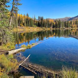
Do take the time to familiarize yourself with Millcreek Canyon, the rules, the trails, the trailheads, the fees, and more. It's super close to SLC and it's well used, and it's got a few things you need to know. As a basic primer, though, know that dogs are allowed up here off leash on odd numbered days, you have to pay a nominal fee to use the canyon, and the trail system winds around and connects up with other trails, other canyons, and can go by different names. Just have a map handy and you'll be just fine. 
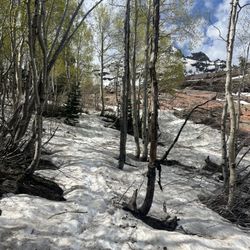
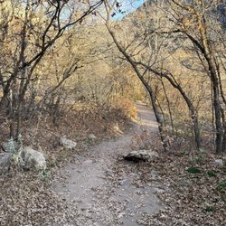
Rattlesnake Gulch itself is just that: a gulch on the north side of the road that carves up the middle of Millcreek Canyon, and it's the southern exposure. It's one of the first areas that is freed up from snow in the winter as it's low enough in elevation to not get too terribly snowpacked. The trailhead sits on the north side of the road, at roughly 3/4 of a mile after you pass the fee station. 
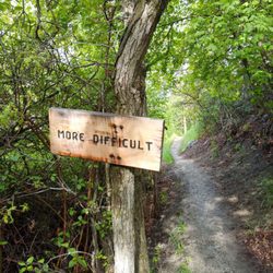
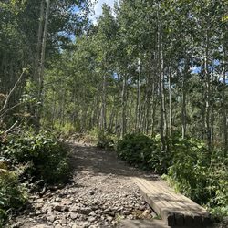
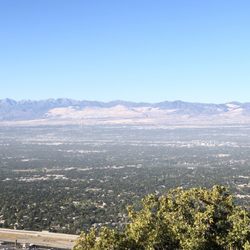
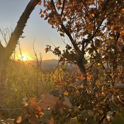
Strictly speaking, the Rattlesnake Gulch portion of this hike is only about .7 miles long. It runs straight up the belly of the gulch through somewhat steep terrain, with good maple and oak cover, until finally meeting up with the Pipeline Trail (listed separately here on Yelp). Most people who do this hike, though, don't just end at the Pipeline Trail, they head west on the Pipeline Trail and take it to the bend that overlooks the Salt Lake Valley. This portion is nearly flat, but totally exposed to sun. You can technically continue down the trail from there further, but most folks stop. The views are incredible, but for my money, the best views are near dusk when the last sun hits the canyon walls just across from you. To do that entire portion--from the trailhead, up Rattlesnake Gulch, and to the overlook on the Pipeline Trail, is about 1.8 miles each way. That makes it a lovely after-work 3.6 mile adventure that shouldn't take much longer than 1.5-2 hrs depending on how long you sit there and gaze. I did just that the last time I was here. I came up the Gulch, hit the Pipeline, and then just gazed at the overlook. It's amazing the insights you can get when you just listen. I just sat there and let the wind hit me, watched the sun eek out its last few rays of the day, and I looked at the city below. I thought about a lot of things, about trails, about the paths we take, and about trees. I thought about Rattlsenake Gulch, and how it sounds scary, and it's a lot of work to climb up, but I thought about the payoff. I thought about how we go through long, hard times that hurt, but that when we do hard things that scare us, if we just picture the destination we can take the courage we need to get from point A to point B. We can get from where we are to where we want to be. And when we do get to where we want to be, it's really worth it. Join me at the overlook, ya?

    Photos
    Rattlesnake Gulch Trail
    Rattlesnake Gulch Trail
    Rattlesnake Gulch Trail

    See all

    Lambs Canyon Trailhead

    Lambs Canyon Trailhead

    4.5(2 reviews)
    11.0 km

    I've hiked Lambs Canyon twice, once in the middle of summer, and most recently as autumn has…read morestarted. It is just under four miles round trip, with a fairly gradual incline, although there are bits that can be a little steep. The trailhead starts with a bridge over water, but then quickly veers away from the stream, although you'll still catch faint babbling sometimes. The trail is fairly shaded, but also has plenty of open areas. It's much less rocky than other hikes, though this means more mud when it's rainy. Otherwise it's a great option for trail runs. A few of the plants you'll encounter are aspen, pine, wild elderberries, currants, and strawberries. The wildflowers are supposed to be stunning when in bloom. I saw chipmunks, various birds, moose and elk tracks, and while I haven't discovered any myself, have heard tales of rattlesnakes in the summer. It's definitely less traveled, though you'll likely come across at least a few groups. The terminus of the hike brings you to a scrubby sort of field with views out over the valley, and honestly, it's a bit underwhelming compared to some of the grander views you can find on hikes in the area, but the way there is enjoyable, and you have the option of taking a different route back down to Millcreek Road (though it would require a shuttle back to your car at the end). Once you take the exit off of I-80 for Lamb's Canyon you'll drive about a mile to get to the trailhead. There are restrooms available, and parking for maybe 5 or 6 cars. Dogs are not allowed.

    Beautiful for a wildflower hike or just to beat the SLC heat in the summer. It's so green and lush…read moreup here. Love it!

    Photos
    Lambs Canyon Trailhead
    Lambs Canyon Trailhead - Beautiful aspens

    Beautiful aspens

    Lambs Canyon Trailhead - End of trail

    See all

    End of trail

    Bell Canyon - Stream

    Bell Canyon

    4.4(43 reviews)
    9.4 km

    Everywhere I look these days, it seems that people are posting pictures of amazing fall colors. We…read moredo live in a beautiful state and it's appropriate for us to step outside, take a look around and appreciate when nature shows off. I joined a group of hikers and hit the trails this past week, in search of some great fall colors. Bell Canyon did not disappoint. There is plenty of parking at the trailhead, including clean bathrooms. The first part of the trail is pretty rocky and has a decent elevation gain-poles are helpful, but at the least, have good shoes with some traction. Once you get to the reservoir, it's pretty flat and there are lots of places you can get amazing pictures. Be sure to take some time down by the water-it's so calming and just beautiful. There were some detour signs on the trail, so we didn't get the full experience (not sure why it was closed, but we tried to follow signs until they suddenly stopped. So we turned around and came the way we went.) Overall, it's a beautiful hike and I'd love to come try it again when the trail is open.

    We started at the entrance on Wasatch Blvd near the residential area; and then, ended up at the…read morewaterfall. It took us about 4 hours to hike approx. 6 miles with short breaks in between for water. It's a mixer of flat, incline, rocky, slippery (snow still out towards end of hike), upward steps, and mini bridges to cross over small water streams. There are surrounding plants and trees, but most are barely blooming. Didn't see any wildlife animals, but saw a few squirrels crossing our paths lol. The hike itself wasn't too hard. I'd rate it intermediate. It was only challenging because the paths towards the end were slippery due to snow still out and melting. It was fun with some close calls. Luckily I found a stick on the way to use. We passed by the lake at the beginning of the hike, which was nice. Once we reached the waterfall, we took a refreshing break; snacked a bit; embraced the beautiful nature; and then, headed back where we started. It was harder to hike down the slippery snow than it was to hike to the waterfall. I'd come back to hike this place during fall to see the vibrant color of the trees.

    Photos
    Bell Canyon
    Bell Canyon
    Bell Canyon - The universe sent me here

    See all

    The universe sent me here

    Hidden Falls - hiking - Updated May 2026

    Loading...
    Loading...
    Loading...