Salt Lake Valley Overlook Hiking Photos


You might also consider
More like Salt Lake Valley Overlook
Recommended Reviews - Salt Lake Valley Overlook
Start your review...

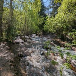
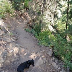
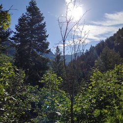
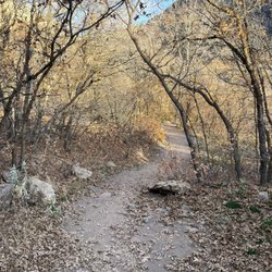
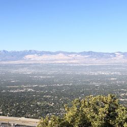
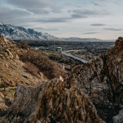
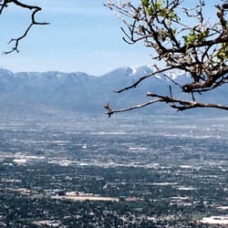
This is a 2.7 mile hike up to the overlook. Trail follows Desolation Trail up Thaynes Canyon. This is a very narrow busy, rocky, trail that allows dogs. Most of the trail is in the shade with some parts in direct sunlight. There are a few rock scrambles the closer you get to the lookout but are doable. Watch your step passing as there are a few sections of the trail that are right next to the cliffs edge. When you get to the overlook there are a couple of big rocks that you can climb to get that extra special picture of the valley. If you come at sundown you will get some fantastic sunset pictures. This is a really good hike with a steady elevation gain to get your heat pumping but is short enough to not take all day. Highly recommended. read more


2 years ago
More info about Salt Lake Valley Overlook
You might also consider


Why does Yelp recommend reviews?
1 review that is not currently recommended
The reviews below are not factored into the business's overall star rating.
3 years ago
Salt Lake Valley Overlook - hiking - Updated May 2026
Best of Mount Olympus
People found Salt Lake Valley Overlook by searching for…
Sunset View in Mount Olympus, UT
Scenic View in Mount Olympus, UT
Places to Take Pictures in Mount Olympus, UT
Scenic Overlook in Mount Olympus, UT
Things to Do in Mount Olympus, UT
Walking Trails in Mount Olympus, UT
Watch Sunset in Mount Olympus, UT
Hiking Trails in Mount Olympus, UT
Beautiful Views in Mount Olympus, UT
Night View in Mount Olympus, UT
Sunday Fun Things to Do in Mount Olympus, UT
Easy Hikes in Mount Olympus, UT
Dog Friendly Hiking Trails in Mount Olympus, UT
Factory Tours in Mount Olympus, UT
Lakes & Ponds in Mount Olympus, UT
Night Hike in Mount Olympus, UT
Lookout Points in Mount Olympus, UT
Off Leash Dog Hikes in Mount Olympus, UT
Running Trails in Mount Olympus, UT
Fun Things to Do at Night in Mount Olympus, UT
Photo Spots in Mount Olympus, UT
Browse Nearby
BEST of Mount Olympus, Utah Restaurants near Salt Lake Valley Overlook
BEST of Mount Olympus, Utah Coffee near Salt Lake Valley Overlook
BEST of Mount Olympus, Utah Things to Do near Salt Lake Valley Overlook
BEST of Mount Olympus, Utah Parks near Salt Lake Valley Overlook
BEST of Mount Olympus, Utah Breakfast near Salt Lake Valley Overlook
BEST of Mount Olympus, Utah Shopping near Salt Lake Valley Overlook
BEST of Mount Olympus, Utah Hotels near Salt Lake Valley Overlook
Browse Brands
Browse Articles
People who viewed Salt Lake Valley Overlook also viewed
The Living Room Trail
39 reviews
University, East Bench
Donut Falls
72 reviews
Cecret Lake
24 reviews
Little Water Trail
2 reviews
Hidden Falls
1 review
Jordan River Parkway Trail
10 reviews
Hell Canyon Trail
1 review
Capitol Hill
Mount Timpanogos Wilderness Area
14 reviews
Lake Mary Trail
10 reviews
Deuel Creek South Trail
1 review