Desolation Trail Photos


 - Hiking Near Me - Salt Lake City, Utah")

You might also consider
More like Desolation Trail
Recommended Reviews - Desolation Trail
Start your review...

Reviews With Photos

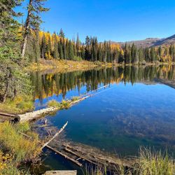
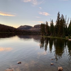
Desolation trail was one that we stumbled on accidentally. We were heading towards Dog lake but along the way we kept asking hikers that were on their way back which one is worth it. Desolation is so so beautiful!! It turns out that dog lake is covered in flies and mucky brown water. Desolation was like finding Hawaii water in a forest. Breathtaking lake at the end. The entire trail is 8 miles there and back. Please bring lots of water and bug spray!! Much needed on this trail. It's fairly easy to give up because it's a lot of uphill paths but oh so worth it in the end! Beware of the bikers zooming by on the downhill slopes. They are very fast and sometimes give no warning. We kept passing by hikers saying that they found a moose mamma and baby. We did not see them but it hearing that made us not look at our shoe laces as much so I was great full for that. There is a ton of view points that offer stellar picture perfect views. Sometimes I felt like I was in a movie because it was all too beautiful!! I'm very glad Lori and I went hiking with Andy and Sadie. They were great company and I had a fun time getting to know them! This hike was worth everything once you get to the beautiful blue and turquoise water. It's surrounded by red sand so that makes it so much more unique!! Sometimes it feels like it was a dream coming here but I'm so grateful that I have this spot as a fun and stellar memory!

10 years ago
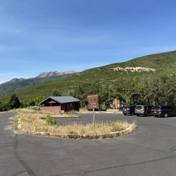
This has two trailheads, so please note that the pin drop here on Yelp (as of today) is on the Millcreek Canyon side. If you're looking to hike to Desolation Lake, you can make it there on this trailhead, but it's the loooooong way. For the most direct way to Desolation Lake, you'll want the Beartrap Fork Trail #057, located one canyon to the south in Big Cottonwood Canyon, here: https://www.yelp.com/biz/beartrap-fork-trail-057-salt-lake-city Now that's settled, let's talk about the Desolation Trail. As alluded to above, this is actually quite a long trail that straddles the hump between Millcreek and Big Cottonwood Canyons. Arguably, the most popular section of the hike is here at the Millcreek side, as it delivers hikers a nifty vista after a few miles. First, find the trailhead by going east up Millcreek Canyon. You'll pass the series of Cub Scout and Boy Scout camps on the south side, and come to the Church Fork Picnic area on the north (left) side. Once you pass that, the South Box Elder Picnic Area appears on the south (right) and this is where the trailhead begins. The trailhead hosts a small pit toilet building but there is no available electricity or water, so bring your own before you arrive. There are a few small picnic tables on a first come-first served basis, as well as the Edmund Ellsworth picnic area, which can be reserved ahead of time. Begin the ascent behind the restrooms and you'll see a few signs to begin: first, note that the beginning of the hike is on private property. The Boy Scouts allow the public trail to cross the property, so be nice, and stay on trail. The other sign you see is a mileage indicator which reads: Salt Lake Valley Overlook 2 Thaynes Canyon 3 Porter Fk. Trail 8.5 Mill B North Fk. 9 Bowman Fk. 10.5 Dog Lake 16.5 Desolation Lake 18 Far and away, the most popular hike here is the Salt Lake Valley Overlook. Though marked at 2, it's arguably more like 2.2, making a nice but challenging 4.4 mile round trip activity. This is infinitely doable as an after-work hike in the long days of summer, and even in less illuminated conditions the trail is well worn and can be accomplished on days when you sneak out of the office early. Expect to see lots of traffic those first few miles. Also note that Millcreek Canyon is a popular spot for dog owners, and dogs are allowed on trails and offleash on odd-numbered days of the month. If pups ain't your thing, stick to even-numbered leash days, or skip to the south for the dog-prohibited Big and Little Cottonwood Canyons. The Salt Lake Valley Overlook is as far as I've taken the trail from Millcreek. On the other side, I've run around BCC, Dog Lake, and Desolation Lake as a younger fellow and trail is remarkably similar. Expect to find shorter but thick foliage in sunnier, lower elevations. As you rise or find shady sides of the canyon, you can find stands of pine and other evergreens. The flowers light up from early spring and take turns all season; scarlet gilia, lupine, the occasional mountain aster, Indian paintbrush, and many others. The trailhead sits at about 5750ft in elevation. Salt Lake Valley Overlook takes you to just over 7000ft. It's never technical, the trail is almost exclusively dirt (read: dusty in the summer) but it's a constant climb and can get the best of less-than-seasoned hikers. Still, it's a good choice if you have a healthy group. The full Desolation Trail (which, as far as I can tell, ends at Desolation Lake) maps out on paper to be 16 miles, but is listed at 18. The lake itself sits at just over 9200 ft, so you shouldn't be surprised that the Desolation Trail is a constant climb for over 6 miles before calming down and dropping to around 8800ft over the next 7 or so miles, reaching Dog Lake, dropping to around 8300, and then lifting back up over the 9K mark to reach the waters of Desolation. Here again, you're looking at high elevation forest, although never terribly thick, and a lot of shrub and deciduous groves. Pack plenty of water, even if you're just headed to the overlook. Some of it is exposed, and it's a pretty dry hike. Sunblock is a must, because no matter what time of day or season, you're going to pass stretches that are exposed. We're spoiled to have something like this, and all the other great trails, so close to us in SLC. the Salt Lake Valley Overlook is quite the sight, and that's just about 2 miles away. The whole journey -- one I've not completed in a continuous slog, to be clear -- is on my conquer list and a real treat for anyone looking to head for the hills on a summer day. read more


9 years ago
Millcreek canyon is one of my favorite canyons solely for the fact that dogs are allowed up (it's also beautiful). There are plenty of trails will all sorts of difficulty levels to hike. There is a $3 fee per car so always keep that in mind. (I buy the annual pass because it is worth it for me.) Desolation trailhead parking takes you up a way and then has a few separate trails you can hike once you get up the path a way. There is the Thaynes Canyon trailhead which is about 5.8 miles roundtrip. Salt Lake Overlook which is about 4.4 miles around roundtrip. Desolation Trail is about 18 miles and Dog Lake is 16.5. The paths are very well maintained and it's beautiful! The fall colors were incredible this time of year. It is an easier hike with gradual elevation gain. I also really enjoy snowshoeing this trail because it is so well maintained. Bikes are allowed on the trails and they have doggy bags at the beginning of every hike. SO CLEAN UP AFTER YOUR DOGS. read more


We hiked to desolation lake from big cottonwood canyon via Dog Lake Trailhead. Late December with snow shoes on. Note that about 2 miles in near junction for dog lake is uphill for a while after you pass the sign. Around 3.5 miles in you reach a meadow. Be sure to stay left as most of the tracks led right to the summit and veers away from the lake. Visit early in the morning as the afternoon gets crowded and let's be honest, we snow shoe to be in nature and away from the humans. Desolation is much less busy than dog lake. read more

Desolation trail was one that we stumbled on accidentally. We were heading towards Dog lake but along the way we kept asking hikers that were on their way back which one is worth it. Desolation is so so beautiful!! It turns out that dog lake is covered in flies and mucky brown water. Desolation was like finding Hawaii water in a forest. Breathtaking lake at the end. The entire trail is 8 miles there and back. Please bring lots of water and bug spray!! Much needed on this trail. It's fairly easy to give up because it's a lot of uphill paths but oh so worth it in the end! Beware of the bikers zooming by on the downhill slopes. They are very fast and sometimes give no warning. We kept passing by hikers saying that they found a moose mamma and baby. We did not see them but it hearing that made us not look at our shoe laces as much so I was great full for that. There is a ton of view points that offer stellar picture perfect views. Sometimes I felt like I was in a movie because it was all too beautiful!! I'm very glad Lori and I went hiking with Andy and Sadie. They were great company and I had a fun time getting to know them! This hike was worth everything once you get to the beautiful blue and turquoise water. It's surrounded by red sand so that makes it so much more unique!! Sometimes it feels like it was a dream coming here but I'm so grateful that I have this spot as a fun and stellar memory! read more


8 years ago
Beautiful place, trail directions aren't clear, hiked for two hours and still never found the overlook. Not an easy hike, long and steep. Absolutely beautiful still and would recommend. You would need at-least 4-5 hours for the round trip. Lots of dogs which was cool since I didn't bring one but if I had I would've been nervous about dog fights. Flys were annoying but I didn't have any bug spray on. read more


More info about Desolation Trail
Ask the Community - Desolation Trail
You might also consider


Desolation Trail - hiking - Updated May 2026
Best of Salt Lake City
People found Desolation Trail by searching for…
Campgrounds in Salt Lake City, UT
Photo Spots in Salt Lake City, UT
Lookout Points in Salt Lake City, UT
Picnic Areas in Salt Lake City, UT
Easy Hikes in Salt Lake City, UT
Beautiful Views in Salt Lake City, UT
Scenic Overlook in Salt Lake City, UT
Hiking Trails With Waterfalls in Salt Lake City, UT
Picnic Areas BBQ Pits in Salt Lake City, UT
Dog Friendly Hiking Trails in Salt Lake City, UT
Running Trails in Salt Lake City, UT
Walking Trails in Salt Lake City, UT
Things to Do in Salt Lake City, UT
Hiking With Kids in Salt Lake City, UT
Off Leash Dog Hikes in Salt Lake City, UT
View Points in Salt Lake City, UT
Hikes With Dogs in Salt Lake City, UT
Camping Sites in Salt Lake City, UT
Scenic Views in Salt Lake City, UT
Waterfalls in Salt Lake City, UT
Trending Searches in Salt Lake City, UT
Botanical Gardens near Desolation Trail
Bounce House Rentals near Desolation Trail
Campgrounds near Desolation Trail
Cliff Jumping near Desolation Trail
Dog Friendly Things To Do near Desolation Trail
Flower Fields near Desolation Trail
Flower Shop near Desolation Trail
Garage Sales near Desolation Trail
Garden Center near Desolation Trail
Lakes & Ponds near Desolation Trail
Nurseries & Gardening near Desolation Trail
Outdoor Activities near Desolation Trail
Outdoor Furniture Stores near Desolation Trail
Party Equipment Rentals near Desolation Trail
Pedicure near Desolation Trail
Photo Spots near Desolation Trail
Pick Your Own Farms near Desolation Trail
Picnic Areas near Desolation Trail
Places To Take Pictures near Desolation Trail
Rock Quarry near Desolation Trail
Running Trails near Desolation Trail
Rv Rental near Desolation Trail
Strawberry Picking near Desolation Trail
Sunrise View near Desolation Trail
Swimming Holes near Desolation Trail
Table And Chair Rentals near Desolation Trail
Browse Articles
Browse Nearby
Browse Brands
Related Searches in Salt Lake City, UT
Affordable Kayak Rental Services in Salt Lake City, Utah
Best Fishing Locations and Guides in Salt Lake City, Utah
Best Places for Horseback Riding in Salt Lake City, Utah
Best Waterfalls and Swimming Holes in Salt Lake City, Utah
Check Out Off Road Trails in Salt Lake City, Utah
Discover Dog Friendly Trails to Explore in Salt Lake City, Utah
Discover Scenic Mountain Bike Trails Near Salt Lake City, Utah
Discover Scenic Waterfall Spots in Salt Lake City, Utah
Discover Top Scenic Spots to Visit in Salt Lake City, Utah
Discover Top State Parks to Visit in Salt Lake City, Utah
Discover a Hiking Trail in Salt Lake City, Utah
Discover the Best Night Hike Trails in Salt Lake City, Utah
Dog-Friendly Hikes With Dogs in Salt Lake City, Utah
Enjoy Camping Adventures Around Salt Lake City, Utah
Enjoy Exciting Mountain Biking Adventures in Salt Lake City, Utah
Enjoy Kayaking Adventures in Salt Lake City, Utah
Enjoy River Tubing Adventures in Salt Lake City, Utah
Enjoy Tent Camping Spots Around Salt Lake City, Utah
Enjoy Water Activities and Fun in Salt Lake City, Utah
Enjoy a Beautiful Waterfall Hike in Salt Lake City, Utah
Enjoy the Best Picnic Spots and Ideas in Salt Lake City, Utah
Enjoy the Best Walking Trails in Salt Lake City, Utah
Exciting Cliff Jumping Spots in Salt Lake City, Utah
Experience Thrilling White Water Rafting in Salt Lake City, Utah
Explore Beautiful Parks and Green Spaces in Salt Lake City, Utah
Explore Easy Hikes Perfect for All in Salt Lake City, Utah
Explore Fun Activities to Do in Salt Lake City, Utah
Explore Nature Spots Around Salt Lake City, Utah
Explore Popular Campgrounds Near Salt Lake City, Utah
Explore Scenic Lakes to Visit in Salt Lake City, Utah
Explore the Best Swimming Holes Around Salt Lake City, Utah
Explore the Best Trail Options in Salt Lake City, Utah
Family Friendly Hiking With Kids in Salt Lake City, Utah
Find Beautiful Views in Salt Lake City, Utah
Find Popular Ziplining Spots Around Salt Lake City, Utah
Find the Best Parks for Picnics in Salt Lake City, Utah
Find the Best Scenic View Locations in Salt Lake City, Utah
Hiking Trails With Waterfalls in Salt Lake City, Utah
Off Leash Dog Hiking Trails in Salt Lake City, Utah
Plan a Scenic Drive Route Near Salt Lake City, Utah
Popular Outdoor Activities to Try in Salt Lake City, Utah
Popular Picnic Spots to Visit in Salt Lake City, Utah
Popular Things to See in Salt Lake City, Utah
Safe River Swimming Areas in Salt Lake City, Utah
Safe and Fun Parks for Kids in Salt Lake City, Utah
Top Climbing Spots and Gyms in Salt Lake City, Utah
Top Running Trails to Explore in Salt Lake City, Utah
Top Swimming Lakes to Enjoy in Salt Lake City, Utah