The Y Photos


You might also consider
More like The Y
Recommended Reviews - The Y
Start your review...

Reviews With Photos

Yesterday, my son and I, along with some other family, decided to hike up to the Y above Provo in Utah. At first it wasn't too bad. As we kept climbing, it got harder and harder. I live in Oregon at almost sea level. Maybe 200 ft. above sea level. When we started the hike, we were at about 5100 ft. Above sea level. I think it started affecting me a little. When we got to the top, we were at about 6150 ft. Above sea level. It wasn't easy for me, but it was worth it. The view is incredible and amazing. If you are in the area and have time, you should do it. I'm sure if I lived here my body would acclimate to the altitude. People from the area were jogging up and down. I was definitely impressed. It's for sure a great workout.

Be prepared for a steep hike and a huge change in elevation. It's only about .95 to the bottom of the Y! It's a great hike to see the whole of Utah valley! The signs are funny and encourage you along the way- "Great start, Keep Going, Your almost there" Summer: It can get very very hot so make sure to be covered, wear sunscreen, and bring water! Winter: The snow and ice can be very slippery so make sure to bring proper shoes and spikes! Normal hiking boots will not cute it in the weather. Spring: The melting snow and rain can lead to muddy and slippery surfaces so make sure to be careful!

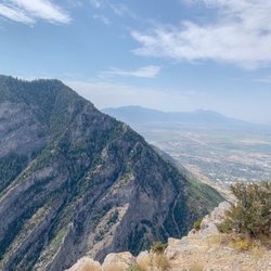
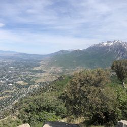
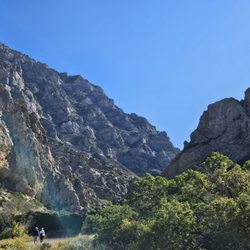
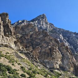
The Y is a classic hike for many BYU students and people that come to visit. Though it's fairly short, it is somewhat steep. Be prepared for the altitude to hit you hard if you're coming from sea level. Besides the hike, the parking lots have beautiful views of the valley and there are small paths that run alongside the mountain for runners, walkers, and mountain bikers. It can often be muddy so be prepared. Sunsets are great from up here!

Great little (but tiring) hike if you're looking for something to do after work. I caught the sunset by the time I got up there. The Y itself wasn't anything special but that's probably because there was snow on it and I couldn't really distinguish where it was. Great place for sunset selfies once you reach the top

This is a great hike. I came on a Saturday and it was very popular with lots of people. Don't like the fit people going by fool you, this is a difficult hike but doable. There is a steep incline essentially for the whole hike. There are signs at each switchback to motivate you keep going. There are also some benches at various places for resting. I would recommend doing this hike in the morning or evening. We came around 10 and there was still a good amount of shade but came down around 11:30 and it was all sun. The top keeps going after the Y if you want to add more to the hike. You can see you car in the parking lot for most of the hike if you are interested in keeping an eye on your vehicle.

Wow! Harder than I expected. Going up, the elevation change is fast, and I had to rest every tenth mile or so. There's benches and rocks along the way to sit if you want. The trail is wide and definitely family and pet friendly. The view of Provo from the top is very nice, and walking around the giant Y is fun. Going down is much faster and easier, and I saw some people jogging it which is definitely an option for everyone as it's all downhill. There's a short trail along the bottom of the Y trail that's much flatter and can sustain mountain bikes. If you add the Y trail with this other trail, you can definitely do 3 miles roundtrip. Overall, very nice. I think this trail averages to medium difficulty but it's still worth doing if you're new to hiking - just take some water with you and allow enough time to get up (at least an hour to go roundtrip) and you'll be good.

The Y was the first mountain I've ever hiked. I didn't really know what I was expecting, but all I know was that I was determined to reach the top. This is one steep hike, I'll tell you that, also the change in elevation killed my legs and thighs. I think I gave up like 5 times, but picked myself back up and pushed forward. Luckily there are benches and huge rocks along the trail for you to sit on and take a breather. In the end I made it to the top and was rewarded with such a beautiful view. It was definitely worthwhile.


1 year ago
I used to hike the Y regularly back in my younger days (and let's be very, very clear--I'm not *that* old yet). But this week I took my kids up, and it was an awesome, nostalgic experience. I was worried the little ones wouldn't make it, but joke's on me--*I* was the one huffing and puffing like an overheated freight train. It's not a super hard hike if you're in decent shape, but if you've been skipping leg day (or cardio day, or all days like I have), pro tip: take you time. The views are worth it, and so is the sense of accomplishment once you hit the top. Still one of Provo's best. read more


2 years ago
why oh why would you miss out on the opportunity to go to the Y? its a provo classic and i knew i had to take my husband here asap. the view of the valley is wonderful at night and provides a wonderful atmosphere. 10/10 recommend sitting on the top of your car, popping some champagne and having the first kiss with the love of your life up there. what happens at the Y stays at the Y and Y would you not go? Y not read more


Caught the sunset here... We came up here just for the amazing views, no hiking. We spent some time enjoying panoramic sceneries of the Provo area and Utah Lake. There are different sections to park and enough spaces in the parking lot. The houses on the hills are beautiful on the drive up. I wonder how much real estate is up here. We followed that giant Y just above BYU. It is a popular trail among locals and students... as well as visitors. You can bring pets on your hike, they must be on a leash and, of course, must clean up after them. At the start of the hike you are already at 6,076-ft so there is some elevation there already. You've had gained another 145 feet if you make it to the top of the Y at 6,221-ft. Seems easy? Well, be prepared because it's steep and can be slippery and falling rocks are a possibility. It was a peaceful Sunday evening watching the sun set from the parking lot and the weather was nice and comfortable. Review #1792 read more


6 years ago
Yesterday, my son and I, along with some other family, decided to hike up to the Y above Provo in Utah. At first it wasn't too bad. As we kept climbing, it got harder and harder. I live in Oregon at almost sea level. Maybe 200 ft. above sea level. When we started the hike, we were at about 5100 ft. Above sea level. I think it started affecting me a little. When we got to the top, we were at about 6150 ft. Above sea level. It wasn't easy for me, but it was worth it. The view is incredible and amazing. If you are in the area and have time, you should do it. I'm sure if I lived here my body would acclimate to the altitude. People from the area were jogging up and down. I was definitely impressed. It's for sure a great workout. read more


6 years ago
Be prepared for a steep hike and a huge change in elevation. It's only about .95 to the bottom of the Y! It's a great hike to see the whole of Utah valley! The signs are funny and encourage you along the way- "Great start, Keep Going, Your almost there" Summer: It can get very very hot so make sure to be covered, wear sunscreen, and bring water! Winter: The snow and ice can be very slippery so make sure to bring proper shoes and spikes! Normal hiking boots will not cute it in the weather. Spring: The melting snow and rain can lead to muddy and slippery surfaces so make sure to be careful! read more


The Y is a classic hike for many BYU students and people that come to visit. Though it's fairly short, it is somewhat steep. Be prepared for the altitude to hit you hard if you're coming from sea level. Besides the hike, the parking lots have beautiful views of the valley and there are small paths that run alongside the mountain for runners, walkers, and mountain bikers. It can often be muddy so be prepared. Sunsets are great from up here! read more


6 years ago
Great little (but tiring) hike if you're looking for something to do after work. I caught the sunset by the time I got up there. The Y itself wasn't anything special but that's probably because there was snow on it and I couldn't really distinguish where it was. Great place for sunset selfies once you reach the top read more


2 years ago
5 years ago
This is a great hike. I came on a Saturday and it was very popular with lots of people. Don't like the fit people going by fool you, this is a difficult hike but doable. There is a steep incline essentially for the whole hike. There are signs at each switchback to motivate you keep going. There are also some benches at various places for resting. I would recommend doing this hike in the morning or evening. We came around 10 and there was still a good amount of shade but came down around 11:30 and it was all sun. The top keeps going after the Y if you want to add more to the hike. You can see you car in the parking lot for most of the hike if you are interested in keeping an eye on your vehicle. read more


Wow! Harder than I expected. Going up, the elevation change is fast, and I had to rest every tenth mile or so. There's benches and rocks along the way to sit if you want. The trail is wide and definitely family and pet friendly. The view of Provo from the top is very nice, and walking around the giant Y is fun. Going down is much faster and easier, and I saw some people jogging it which is definitely an option for everyone as it's all downhill. There's a short trail along the bottom of the Y trail that's much flatter and can sustain mountain bikes. If you add the Y trail with this other trail, you can definitely do 3 miles roundtrip. Overall, very nice. I think this trail averages to medium difficulty but it's still worth doing if you're new to hiking - just take some water with you and allow enough time to get up (at least an hour to go roundtrip) and you'll be good. read more


The Y was the first mountain I've ever hiked. I didn't really know what I was expecting, but all I know was that I was determined to reach the top. This is one steep hike, I'll tell you that, also the change in elevation killed my legs and thighs. I think I gave up like 5 times, but picked myself back up and pushed forward. Luckily there are benches and huge rocks along the trail for you to sit on and take a breather. In the end I made it to the top and was rewarded with such a beautiful view. It was definitely worthwhile. read more

9 years ago
12 years ago
12 years ago
How has no one reviewed this?! The quintessential BYU hike! Takes around an hour round trip, including hanging out in the Y. Great workout and fun, always has at least a few other people for safety :) read more

12 years ago
I love Y mtn and the hike is short in duration and distance and long in elevation. Great hike and beautiful view. read more


11 years ago
8 years ago
More info about The Y
Provo, UT 84604
Directions
Hours
Outdoor Amenities
Ask the Community - The Y
Review Highlights - The Y


Why does Yelp recommend reviews?
1 review that is not currently recommended
The reviews below are not factored into the business's overall star rating.
12 years ago
The Y - hiking - Updated June 2026
Best of Provo
People found The Y by searching for…
Trending Searches in Provo, UT
Browse Brands
Related Searches in Provo, UT
Affordable Kayak Rental Services in Provo, Utah
Best Fishing Locations and Guides in Provo, Utah
Best Places for Horseback Riding in Provo, Utah
Check Out Off Road Trails in Provo, Utah
Discover Dog Friendly Trails to Explore in Provo, Utah
Discover Scenic Mountain Bike Trails Near Provo, Utah
Discover a Hiking Trail in Provo, Utah
Discover the Best Night Hike Trails in Provo, Utah
Dog-Friendly Hikes With Dogs in Provo, Utah
Enjoy Camping Adventures Around Provo, Utah
Enjoy Exciting Mountain Biking Adventures in Provo, Utah
Enjoy Kayaking Adventures in Provo, Utah
Enjoy River Tubing Adventures in Provo, Utah
Enjoy Tent Camping Spots Around Provo, Utah
Enjoy a Beautiful Waterfall Hike in Provo, Utah
Enjoy the Best Walking Trails in Provo, Utah
Exciting Cliff Jumping Spots in Provo, Utah
Experience Thrilling White Water Rafting in Provo, Utah
Explore Beautiful Parks and Green Spaces in Provo, Utah
Explore Bike Rentals Throughout Provo, Utah
Explore Easy Hikes Perfect for All in Provo, Utah
Explore Fun Activities to Do in Provo, Utah
Explore Popular Campgrounds Near Provo, Utah
Explore Popular RV Parks Around Provo, Utah
Explore Scenic Lakes to Visit in Provo, Utah
Explore the Best Boating Spots in Provo, Utah
Explore the Best Swimming Holes Around Provo, Utah
Family Friendly Hiking With Kids in Provo, Utah
Find Beautiful Views in Provo, Utah
Find Parks and Recreation Activities in Provo, Utah
Find Popular Ziplining Spots Around Provo, Utah
Find the Best Parks for Picnics in Provo, Utah
Find the Best Playgrounds to Visit in Provo, Utah
Find the Best Scenic View Locations in Provo, Utah
Hiking Trails With Waterfalls in Provo, Utah
Off Leash Dog Hiking Trails in Provo, Utah
Picnic Areas With BBQ Pits Available in Provo, Utah
Plan a Scenic Drive Route Near Provo, Utah
Popular Fishing Spots to Explore in Provo, Utah
Popular Outdoor Activities to Try in Provo, Utah
Popular Picnic Spots to Visit in Provo, Utah
Safe River Swimming Areas in Provo, Utah
Safe and Fun Parks for Kids in Provo, Utah
Top Climbing Spots and Gyms in Provo, Utah
Top Playgrounds for Kids to Enjoy in Provo, Utah
Top Running Trails to Explore in Provo, Utah
Top Swimming Lakes to Enjoy in Provo, Utah
Top Swimming Spots and Pools in Provo, Utah