Quilt Walk Park Photos


You might also consider
More like Quilt Walk Park
Recommended Reviews - Quilt Walk Park
Start your review...

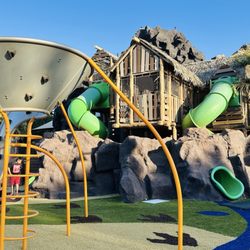
This small, in-town park represents a very cool story about a few brave men who answered the call to service when they were needed. It represents and relates the story of seven men who braved harsh winter conditions to retrieve food in Parowan for their starving families and fellow townsmen. The park has memorials for each of the members of that expedition. It is a fitting commemoration for that noteworthy event and explains the intimate connection between Panguitch and quilts. read more


More info about Quilt Walk Park


Quilt Walk Park - parks - Updated May 2026
Best of Panguitch
People found Quilt Walk Park by searching for…
Fishing Spots in Panguitch, UT
Places to Take Pictures in Panguitch, UT
Parks and Recreation in Panguitch, UT
Things to See in Panguitch, UT
Places to Run in Panguitch, UT
Scenic Night View in Panguitch, UT
Open Gym Basketball Court in Panguitch, UT
Tourist Attractions in Panguitch, UT
Points of Interest in Panguitch, UT
Walking Trails in Panguitch, UT
Trending Searches in Panguitch, UT
Browse Articles
Browse Nearby
BEST of Panguitch, Utah Things to Do near Quilt Walk Park
BEST of Panguitch, Utah Hiking near Quilt Walk Park
BEST of Panguitch, Utah Restaurants near Quilt Walk Park
BEST of Panguitch, Utah Coffee near Quilt Walk Park
BEST of Panguitch, Utah Star Gazing near Quilt Walk Park
BEST of Panguitch, Utah Campgrounds near Quilt Walk Park
BEST of Panguitch, Utah Watch Sunset near Quilt Walk Park
BEST of Panguitch, Utah Breakfast near Quilt Walk Park
BEST of Panguitch, Utah Natural Hot Springs near Quilt Walk Park
Browse Brands
Related Searches in Panguitch, UT
Best Nature Trails for Hiking in Panguitch, Utah
Best Places for Horseback Riding in Panguitch, Utah
Best Spots for Star Gazing in Panguitch, Utah
Check Out Off Road Trails in Panguitch, Utah
Discover Popular Bike Trails in Panguitch, Utah
Discover Popular Photo Spots in Panguitch, Utah
Discover Top Nature Parks to Visit in Panguitch, Utah
Discover the Best Night Hike Trails in Panguitch, Utah
Discover the Best Running Track in Panguitch, Utah
Dog-Friendly Hikes With Dogs in Panguitch, Utah
Effective Stairs Workout Spots in Panguitch, Utah
Enjoy Scenic Night View Experiences in Panguitch, Utah
Enjoy the Best Night View Spots in Panguitch, Utah
Enjoy the Best Picnic Spots and Ideas in Panguitch, Utah
Enjoy the Best Walking Trails in Panguitch, Utah
Exciting Cliff Jumping Spots in Panguitch, Utah
Experience Stunning Sunset Views in Panguitch, Utah
Explore Easy Hikes Perfect for All in Panguitch, Utah
Explore Free Picnic Areas Around Panguitch, Utah
Explore Landmarks & Historical Buildings in Panguitch, Utah
Explore Popular Campgrounds Near Panguitch, Utah
Explore Popular RV Parks Around Panguitch, Utah
Explore Popular Scenic Overlook Points in Panguitch, Utah
Explore Popular Scenic Views Near Panguitch, Utah
Explore Popular View Points Around Panguitch, Utah
Explore Scenic Lakes to Visit in Panguitch, Utah
Explore Secret Spots Worth Visiting in Panguitch, Utah
Explore Top Gyms in Panguitch, Utah Now
Explore the Best Swimming Holes Around Panguitch, Utah
Explore the Best Trail Options in Panguitch, Utah
Find Beautiful Views in Panguitch, Utah
Find Fun Kids Activities Outdoor in Panguitch, Utah
Find Parks and Recreation Activities in Panguitch, Utah
Find Top-Rated Waterfalls in Panguitch, Utah Now
Hiking Trails With Waterfalls in Panguitch, Utah
Locate a Public Shower Facility in Panguitch, Utah
Must-See Tourist Attractions Around Panguitch, Utah
Perfect Spots to Watch Sunset in Panguitch, Utah
Plan a Scenic Drive Route Near Panguitch, Utah
Popular Kids Activities in Panguitch, Utah
Popular Things to Do in Panguitch, Utah
Popular Things to See in Panguitch, Utah
Safe River Swimming Areas in Panguitch, Utah
Top Hiking Trails to Explore in Panguitch, Utah
Top Must See Attractions and Spots in Panguitch, Utah
Top Running Trails to Explore in Panguitch, Utah
Top-Rated Boat Rental Services in Panguitch, Utah
Top-Rated Hikes in Panguitch, Utah to Explore