Cancel

    Open app

    Search

    Birdseye Trail

    5.0 (1 review)

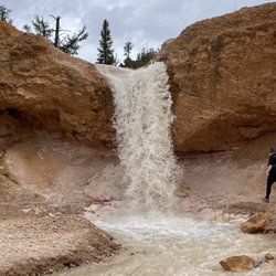
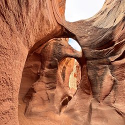
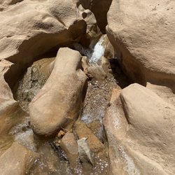
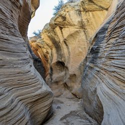
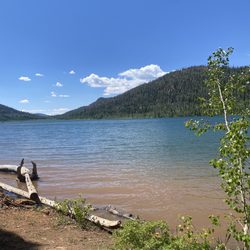
    Birdseye Trail Photos

    You might also consider

    Birdseye Trail Reviews in Other Languages

    Verify this business for free

    Get access to customer & competitor insights.

    Verify this business

    Kanarra Falls - The river is the trail!!

    Kanarra Falls

    4.8(79 reviews)
    73.0 km

    Tons of waterfalls + slot canyon hiking through a freezing river = one of the most epic trails I've…read moreever done! It's like a mini version of The Narrows in Zion. The Kanarra Falls trail is quite an adventure - it's a water hike with some dramatic scenery and intense rock scrambling depending on how far in you go. If you only go to the ladder, I'd say it's a moderate trail. But if you go all the way to the last falls, it's more strenuous. I hiked it in late spring and the water was a balmy 38°F! I did some research and planned ahead to wear thick neoprene socks - But even with my thermal socks, the water was so cold my lower legs were numb for about 60-70% of the trail which made this moderate/strenuous hike even more challenging! So I highly recommend the socks if you're hiking outside of the late summer season bc that water is COLD! And you'll be walking in water depths anywhere from your ankles up to your mid-shins for about 75-80% of the trail. Getting to the first large falls by the ladder isn't terribly difficult and you'll still see several smaller falls along the way. The first part is along a well maintained dirt trail with a few small water crossings before you have to get down into the riverbed. So for those wanting to stop at the top of the ladder, it's still a fantastic and much less strenuous hike. But there are about 3-4 gorgeous falls and slot canyons past that leading up to the last falls that I really would've regretted not seeing. The rock scrambling can get quite difficult- especially for a short person (I'm 5'2"). At one point I had to hoist myself up over some very tall boulders using just my arms and had to do a bit of a chimney crawl up another boulder and a narrow slot wall so be prepared and know your abilities bc I struggled to get back down LOL! I used one of my poles for most of the hike bc the riverbed is very rocky and slippery. I also wore an old pair of my fave Salomon waterproof(ish) hiking shoes with really solid tread - definitely helped. I imagine in the hot weather you'd be fine in some sort of water shoe with no socks but not in winter/spring. Reservations for this hike are required year-round as they limit the number permitted daily to preserve the environment here since this is such a popular trail. It was easy to reserve my spot online and I recommend doing it as far in advance as possible bc spots go fast - especially in the summer. There's plenty of paved parking at the trailhead with nice bathrooms. There are also more bathrooms along the trail right before the first water crossing. It's easy to find - google maps takes you right to the parking area. AllTrails says the trail is 3.6 miles with 656 feet elevation gain but I did just over 5 miles total with 1100+ feet elevation gain by going past the ladder at the first falls - totally worth it - Definitely in my top 5 trails of all time!

    This is an amazing slot canyon hike and is very popular so requires a permit. The permit is only…read more$15 but they only sell 200 a day so some planning is required to visit this location. Not a long trail, only about 4 miles round-trip with very little elevation gain, but Very beautiful mountains and rocks and the slot Canyon is just fantastic!! If you're in the area or passing by, I highly recommend checking it out, an amazing small piece of the Utah's vast scenery...

    Photos
    Kanarra Falls - Got my souvenir - I always get a sticker for my water bottle when I finish a big trail lol!

    Got my souvenir - I always get a sticker for my water bottle when I finish a big trail lol!

    Kanarra Falls - Parking lot at the trailhead

    Parking lot at the trailhead

    Kanarra Falls - Bathrooms on the trail right before the first water crossing - last chance for toilets!

    See all

    Bathrooms on the trail right before the first water crossing - last chance for toilets!

    Peek-a-boo & Spooky Slot Canyon - Desert Skies

    Peek-a-boo & Spooky Slot Canyon

    4.7(16 reviews)
    79.2 km

    Let me set the record straight, slot canyons are my jam! I will go anywhere there is an opportunity…read moreto walk, shimmy, or rappel into a slot canyon. I just think they are the most interesting Mother Nature created places to explore. We came here on a July 4th holiday with some friends of my husbands. The road out here can be rough in spots and does require a 4X4 to get out here, but we made it safely to the canyon. These slot canyons are located within the Grand Staircase-Escalante National Monument in the beautiful state of Utah. This land is run by the BLM. Talk about beautiful! The canyon walls with their orange/red colored Navajo sandstone just envelopes you as you walk through this slot canyons. So many twists and turns with lots of crevices to peer or climb into. Be sure to pack plenty of water, sunscreen, good trail shoes (not Skechers HA! HA!), a hat and a small pack so you can move through the slot canyons comfortably. Both of these canyons are so worth the drive and the time. Most of all remember to Leave No Trace. Happy Adventuring!

    We couldn't get into Peek-a-book Slot Canyon. The entrance is close to 15 feet up and a near…read morevertical approach in three pitches. The rock is slippery with just a hint of footholds. I probably could have gotten up, but don't think I could make it back down safely. The picture attached shows about 20 feet vertically. And not wanting to do Spooky I would have had to come back down that way. A long drive and a bit of a hot hike to find that out. There was a third slot canyon nearby that is easy to access, though not nearly as spectacular as, say, Antelope Canyon near Page, Arizona.

    Photos
    Peek-a-boo & Spooky Slot Canyon - Ancient Moqui Steps in the sandstone

    Ancient Moqui Steps in the sandstone

    Peek-a-boo & Spooky Slot Canyon - Fitting in a crevice

    Fitting in a crevice

    Peek-a-boo & Spooky Slot Canyon - Here we go!

    See all

    Here we go!

    Grand Staircase - Escalante National Monument - Willis Creek Narrows

    Grand Staircase - Escalante National Monument

    4.8(31 reviews)
    79.8 km

    This feels like a review in progress because the area is so large - but was pleasantly surprised by…read morehow much more I want to explore this region. We did Willis Creek Narrows and Lower Calf Creek Falls - both incredible. Now adding to the wish list for return trips. The drive along US 12 is just spectacular. Definitely recommend a high clearance vehicle with 4WD to access some of the more remote locations. Be prepared to adventure and bring what you need as this is not a manicured national park, but more a haven for those looking for an off-grid escape.

    I didn't have a ton of time to explore here but simply driving by left quite an impression on me!…read moreWOW. I'm not exaggerating when I say I pulled off the road maybe every 50 feet because every new angle provided a new exciting view of this vast and beautiful stone monument. In general this is a HUGE monument to explore and I'm not sure you could even scratch the surface on a simple vacation, let alone during a road trip. I've since come to learn that this area was the last part of the lower 48 states to be cartographed and, according to the Bureau of Land Management, it spans five life-zones - from low-lying desert to coniferous forest, and paleontologists have unearthed countless dinosaur bones and fossils from within its canyons and deserts. Truly incredible stuff, here! But don't let the size and scope intimidate you. As I said, even driving by or taking a day or afternoon to explore is worth the journey. It's an incredible resource that we're lucky to have here in the US.

    Photos
    Grand Staircase - Escalante National Monument
    Grand Staircase - Escalante National Monument
    Grand Staircase - Escalante National Monument

    See all

    Willis Creek - My kid is at the top lying on his stomach after making his own path.

    Willis Creek

    4.7(3 reviews)
    48.1 km

    This review is for the Willis Creek Slot Canyon Trail. I've heard of them but never been to one,…read moreand we decided to stop here on the way home to our rental. To get to the trail head, you have to drive in on an unpaved five or so mile road which is scary at times. Make sure you have clearance for your car like the sign says before coming. Our Toyota 4Runner made it through without any problems. After what seems like an eternity because you can't go fast, we got to the head. There's a sign-in book for names, where you're from, and if you're a day or evening/overnight group. Now off to the Slot Canyon! This trail is marked as easy. It's mostly gravel rocks and little steps. My son the adventurous one wanted and did make his own excursion from what others surely have done before. Since it was late afternoon, we decided on a half hour in and then a turn around. The major slot canyon is pretty close to the start of the trail, and it's rather epic. The rocks are so smooth and it can be peaceful in there. I believe because of the remoteness of the canyon, it never seems to be crowded. I would recommend honking shoes, not sneakers, and appropriate clothing for the sun that will bear down on you. Bring lots of water. Watch out for the horse poop! If we weren't so exhausted after a long day, we probably would have hiked along the trail much longer than a half hour, but we definitely got the flavor we were looking for. Have you ever been to an amusement park like Disney where they create mountains and rocks? I can say I've been to the real deal and it's much better.

    Beautiful and special place. Watch out for horse poop up and down the creek. Hike is short and…read moreeasy. The drive up was sketchy, I wouldn't attempt in a 2 wheel drive. We drove an all wheel drive suv and made it. We loved it.

    Photos
    Willis Creek - A natural hole to stick your arm through.

    A natural hole to stick your arm through.

    Willis Creek
    Willis Creek - The slot canyon in its vastness.

    See all

    The slot canyon in its vastness.

    Bryce Canyon National Park - Breathtaking view!

    Bryce Canyon National Park

    4.8(744 reviews)
    29.6 km

    This is a must stop if you are planning a trip out west to hike, bike, horseback ride, or just…read moreenjoy the scenery at one of our nation's stunning national parks. We stopped at the Visitor Center to learn about the protected prairie dogs that reside in the park. This was a special focus that day. They had tables where you can learn about the varieties of prairie dogs in the US as well as why the ones in the park are endangered. We then got to use their provided binoculars to view some of the prairie dogs that live near the visitor center. The highlight of our day was taking a horseback ride. Definitely look into this as an added activity during your visit!

    I am so glad I got to see the one of a kind, incredible landscape of hoodoos (largest concentration…read morein the world) at Bryce. I wasn't prepared for the how large the area was. We first visited Capitol Reef, then Bryce, then Zion. I am glad we did it in that order. I will share my favorite hike, whether I thought the Queen's Garden Trail was worth It and a must-do. The park is 6,600 - 9,000 ft above sea level, so be prepared for less oxygen by walking on a inclined treadmill or hills and colder weather. We spent one day arriving around 8 am to get a parking space. I greatly enjoyed the Sunrise Point to Sunset Point Rim Trail (easy trail)- great for non-hikers, flat, paved and different view of the hoodoos. It is about 1 mile and wheel chair friendly. Midway is a sign to the Bryce lodge. That provides a nice stop for lunch. We had good hamburgers. We did the Queen's Garden trail which descends farther down into the hoodoos, you walk past a few down. It is more gradual than the Navajo Loop and easier of the two. It is 1.8 miles round trip and can take an hour each way depending on how well you do climbs coming up especially at 8,000 - 9,000 ft with less oxygen. I saw a man pushing a wheelchair with his mother down the Queen's Garden Trail. I wouldn't want to be in that chair without a seatbelt and just in case the man's hands slips. I hope he made his way up pushing that chair, since I imagine that was super hard up the steep inclines. I don't enjoy hiking or hills, so for me, it wasn't worth the effort walking back up Queen's Garden Trail and I had been training on a treadmill with a 13 degree incline for a few weeks; I turned around before I made it to the bottom. Looking down at Navajo Loop later, although steeper, I think it would have taken me more into the hoodoo level. My husband did the Figure 8 loop which is both trails. He said after Queen's Garden, there was a boring area then several up and down the hills below before you got to the Navajo Loop. The Wall St section was closed, so look for warnings before you go. A must do is to drive to Rainbow point at 9,115 ft and then stop on the way back. If you are pressed for time, the best stops were: - Natural Bridge - Biggest, tallest natural bridge I have ever seen. - Inspiration Point - 8,100 ft - the columns and rows of hoodoos was beautiful - Bryce Point (must do) - you can see both Sunset and Sunrise points and have the most panoramic view If you have time, stop in the Visitor Center with a small gift shop and watch the short film on how the hoodoos are formed. Bryce Canyon is a unique, bucket list kind of experience and whether you are a non-hiker who loves nature or enjoy challenges of hills and hiking, there is something for everyone.

    Photos
    Bryce Canyon National Park - My son and I

    My son and I

    Bryce Canyon National Park - Hiking x February!! Ciao

    Hiking x February!! Ciao

    Bryce Canyon National Park - Though dry, green bushes still grow and the occasional yellow flower.

    See all

    Though dry, green bushes still grow and the occasional yellow flower.

    Birdseye Trail - hiking - Updated May 2026

    Loading...
    Loading...
    Loading...