Figure 8 Combination Photos


You might also consider
More like Figure 8 Combination
Recommended Reviews - Figure 8 Combination
Start your review...

Wow... now THAT'S what I call a hike!!! This loop is rated as "moderate" on AllTrails, but it's definitely on the harder side of moderate. But the amazing views of the unique hoodoos are what makes this hike worth the trek. Whether you start clockwise or counterclockwise, you are definitely in for a serious workout. The trail is about 6.5 miles long and is a double loop that connects to Wall Street and the Queens Garden via the Navajo and Peekaboo Loop trails. The double loop is where it gets its' name "figure 8 combo". This is a great hike that incorporates so many wonderful highlights within the park since you really get a little bit of everything. I started this hike going counterclockwise from Sunset Point. Connected to the Navajo Loop and took a right down the switchbacks which will lead you to Wall Street. Wall Street is a gorgeous stretch of slot canyons that's honestly a must see if you're coming to Bryce. From there, the trail mellows out and opens up into a a gorgeous canyon filled with beautiful green trees and the cutest little chipmunks. I continued on the Navajo Loop Trail until I connected o the Peekaboo loop. This is where those inclines start to really hit. I climbed up to the top of peekaboo canyon until I reached a plateau that granted me 360 degree views of the stunning hoodoos that surrounded me. The peekaboo trail is also a popular trail for horseback riders, and many of them did pass me by on the trail. From here, I descended back down into the canyon and then back up through more of the marvelous hoodoos. I'd say this stretch of the Peekaboo trail is the most majestic because you literally have these gorgeous rock formations right at your fingertips and it's so insane. I took the Peekaboo loop to the Queens Garden trail. This was my absolute favorite and another amazing landmark that must not be missed. It literally looks like a castle. So crazy that these rock formations are naturally occurring like this. The last and final stretch is extremely tough. It's a steep incline all the way up to Sunrise Point. And let me tell you, EVERYONE who was near me going up this stretch was struggling. It was grueling, but the best part was being rewarded with the magnificent views of Sunrise Point at the top. Plus, the little chipmunks were just so damn cute. Definitely one of the most enjoyable National Park hikes that I've ever done. I feel like I saw so much of the park during this one hike alone. Would absolutely 1000% recommend, but bring lots of water and sunscreen if you're attempting this during the summertime. read more


8 years ago
One cannot fully enjoy the beauty of Bryce Canyon until one descends into the canyon to hike. Although it is stunning to view the hoodoos from the rim, there is not enough depth perception for one's eyes to fully process how vastly different each hoodoo and parts of the canyon are from a bird's eye view. As I hiked throughout the trails, I understood that it was the same canyon but it continually looked like a new canyon from different elevations and points of view. Consequently, I felt like I was falling in love with it over and over again as if it was the very first time. The most travelled hike at Bryce Canyon is not an official trail. The Figure 8 Combination combines three of the park's most popular trails. Why do one great trail when you can do three of them in one shot? It took my friend and me a little over 3 hours to complete the 6.4 mile route. The elevation change is legitimate for a hike but the bigger challenge is the thin air. We found ourselves needing to catch our breath often. Then again, we were snapping photos nonstop so we just utilized those moments to multitask and breath as the views and thin air took our breaths away. There are connecting trails that make up the 6.4 mile combination route. Below are the three main trails that comprise it. Navajo Loop Trail (0.7 miles) The trail begins at Sunset Point. As you walk towards the direction of Inspiration Point, you will see the beginning of the trail and switchbacks. As you descend the initial set of switchbacks, you will see a rock formation called "Thor's Hammer". As the name implies, it looks like Thor's Hammer with the long handle and a rectangular rock at the top. Shortly after you begin the descent, there is a fork and an option to head toward Wall Street. Depending on the time of the year, it may be closed. In the middle of May, it was still closed during my visit. Instead, I went down another set of switchbacks in between two walls of the canyon. There were echoes when visitors spoke within this part of the trail. Moreover, there were distinct Douglas fir trees growing out of the switchbacks. For me, it felt like a magical gate that granted me entrance to a surreal place. Eventually, I made it to a sign for a sharp left that pointed me back towards Two Bridges to complete the Navajo loop. Instead, I kept on going until I made it to a three way intersection that had signs pointing the directions for the Navajo loop, the Peekaboo Loop, or the Queen's Garden Trail. Peekaboo Loop (3 miles) In my opinion, it is clearly the best and most beautiful loop in the park. It provides the best views of the hoodoos because you see them from all different angles and perspectives as you hike next to them and through them. At varying elevations along the trail, you look up at some of them as you will be below some hoodoos. You will also still be above others yet the perspective is drastically different as your view will be from a significantly lesser elevation than the rim. You can truly better appreciate the differences and uniqueness of the many hoodoos in the park via this loop. Queen's Garden Trail (1.7 miles, including the connecting trail from Peekaboo (0.9 miles by itself)) As the name clearly states, the trail leads to Queen's Garden. It is named after a rock formation that supposedly resembles Queen Victoria and the garden she is overseeing. It is a unique part of the park. It is also connected to the trail I took back up to the top of the Rim at Sunrise Point. Moreover, if you only wanted to take a short trek into the canyon, it is definitely the easiest trail to hike down and back up among the options. Regardless, it provides its own unique and special vantage points of the canyon and its hoodoos. If you are visiting and planning a trip to Bryce Canyon and looking for recommendations, feel free to message me for my itinerary. You can also find the electronic copy through the link my profile. read more


More info about Figure 8 Combination
Rim Trl
Bryce, UT 84764
Directions
Hours
Outdoor Amenities


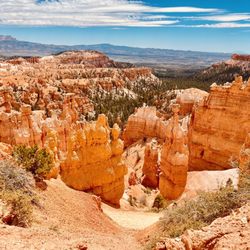
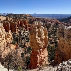


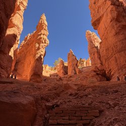


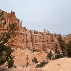

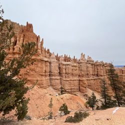


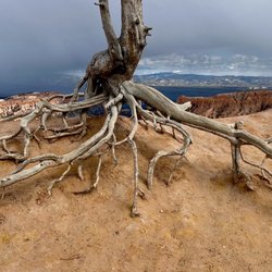
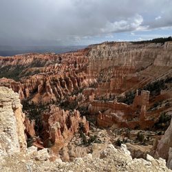
Figure 8 Combination - hiking - Updated June 2026
Best of Bryce
Browse Nearby
BEST of Bryce, Utah Restaurants near Figure 8 Combination
BEST of Bryce, Utah Coffee near Figure 8 Combination
BEST of Bryce, Utah Things to Do near Figure 8 Combination
BEST of Bryce, Utah Breakfast near Figure 8 Combination
BEST of Bryce, Utah Horseback Riding near Figure 8 Combination
BEST of Bryce, Utah Shopping near Figure 8 Combination