Pima Canyon South Mountain Photos


You might also consider
More like Pima Canyon South Mountain
Recommended Reviews - Pima Canyon South Mountain
Start your review...

Reviews With Photos

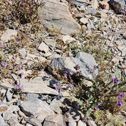
Being that the weather is PERFECT in Phoenix right now I wanted to finally take off and explore more of Arizona and take my toddler, now that she can do so. I did some research and checked out a few trails for an "easy" trail that is kid friendly and came upon Pima Canyon Trail. We went early evening and it was pretty busy but there was still a decent amount of parking. As you can see, my little one was excited and ready to explore. The trail is very gradual, a bit rocky but easy to navigate. There are a ton of bicyclists so it is best to stick to one side to allow them and faster hikers to pass. The trail takes about an hour to complete. The scenery is beautiful and who can't use a little fresh air? I did notice almost everyone there was smiling and friendly as we passed, a sign to hike more often:) There are restrooms, a water station and maps. Do be sure to check the hours, as it is located off the golf course and in a gated area.

My go-to hiking trail with a good warm-up that's flat with some rocks and incline. Lots of space to walk past others and even plenty of mountain bikers. Very pet friendly, and as you get to the "red bench," then you have a few chose your adventure types of paths. National trail is definitely challenging, and paths get smaller, tighter, and higher. There is plenty of parking on and off peak times. Great views of the city, easy, moderate, and difficult paths for everyone... even horses.

This review is for the Pima Canyon Trailhead location off of 48th St. The entrance is near the Rustler's Rooste mountaintop restaurant. This is a hike that I do quite regularly because it is so close to the I-10 and where I live. What I like about it is all the trail options you have. They have a variety of easy to more difficult trails to choose from. There are trail runners, mountain bikers, hikers and people that just want to go for a stroll at this location. Parking isn't bad on the weekdays but can be a real pain on the weekends. Especially during the coolers weather. They built some nice clean bathrooms a few years back at the entrance. There are also some tables with shade that make for a nice spot to meet up with people. The National Trail is is pretty easy and goes for quite a distance. There are several trails that you can access from the National Trail. This is where you see most people walking. The Desert Classic Trail is to the left and goes for about 9 miles. The Marcos De Niza Trail is pretty fun and gives you some great views of both sides of the Valley. The Pima Loop Trails (East and West) and the Ridgeline Trail can be accessed from the Pima Wash Trail to the right. Further down the National Trail you can access Hidden Valley Trail (where they have a natural tunnel you can go through) and Mormon Trail. Fat Man's Pass (a narrow passage between two boulders) is located on the Mormon Trail. There are so many more trails beyond these you can explore. Unfortunately we do get lots of visitors who underestimate our hotter months and don't bring enough water or try to hike in the late afternoons. They do extend the hours during the summer so you can hike earlier. Another thing that sucks is people who bring their dogs and don't pick up their mess. Speaking of dogs, they are prohibited on Phoenix hiking trails when the temperature is 100 degrees or warmer. And keep in mind, this is the desert. I have only seen one snake on this mountain, but do watch out for them even though it's rare to see them. Overall this mountain has tons of options and makes for a nice day out.

A fun, family-friendly trail system in Phoenix. One of the cool things about Arizona hiking trails compared to California trails are the lack of people with Bluetooth speakers blasting offensive rap music while hiking. Even though this trail system is very crowded, the people dissipate the farther you hike. If you make it to the hidden valley, you'll enjoy great views of the city and see two unique natural features. Things to see - 1. Fat Man's pAss - It's a tight fit through two rock walls. Looks a lot tighter than it actually is. Most people can squeeze through it. 2. Hidden Valley Natural tunnel - Yes it's a tunnel but the real "cool factor" will be the large boulders behind the tunnel. Your kids will spend an hour climbing around. Family Tip - Watch out for mountain bikers zooming down the trail. Make sure everyone stays to the right side in a single file. Hiking Tip - If you're really looking for a good hike start hiking from the parking lot, take the national trail to the Hidden Valley Loop (Fat Man's Ass and Hidden Valley Tunnel) then take the unmarked path to the Midlife Crisis trail (top of the small mountain) and head north back to the parking lot along the ridgeline. You'll probably need to open google maps and have GPS on, but on the map you will see the trail ( a little bit past the tunnel) to get you to the Midlife Crisis ridgeline trail. Follow the trail north. The trail changes names to the "Scott Ridge Trail" on the map. From there keeping heading north (it runs parallel to the National Trail) and go all the way back to the parking lot.


Terrific desert hiking trails conveniently located close to Tempe, AZ. Lots of trails and mountains branch off a main wide trail. I only hiked a fraction of this park. And I've seen pictures of trails further in, such as fat man's pass, it looks remarkable! But I really enjoyed my early morning hike in here. Climbing up the first mountain on the left upon entering, it was refreshingly more rugged than I expected but very enjoyable and exhilarating! And it didn't take more than 15 to 20 minutes to get to the top of this smaller peak, A great little side hike! After coming down this mountain, I returned to the main trail which goes right between a bunch of mountains on the ground level. I can see other trails running parallel off to my right side, with joggers and other groups exploring those. Mountain biking here is common as well. Really a great place to go if you're looking to do some easily accessible hiking. The fauna at least near the entrance to the park, wasn't the best I've seen. But it definitely was good, solid desert terrain and enjoyable. I explored a few other side trails and hills. Overall I liked it so much I plan to go back there the next day, especially since it's closer to my hotel then other favorites like Camelback Mountain and Tom Thumb mountain. Just a warning, during 2017 they are doing construction at the entrance to this park. They make you park a half a mile away from the trailhead, which is inconvenient. You spend your first half mile of your hike walking down the access road to get to the trailhead. But besides that, it was a very exciting experience. Definitely recommended for hiking in the Tempe, AZ area.

One of my favorite hiking spots. This is a classic hiking, mountain biking, equestrian and trail runners paradise. This enterance is Super busy especially durring the weekend. Note if you haven't ever hiked here the South Mountain Preserve is about 50 square miles. Be sure to you have a plan and know what trail you are on and where you are going. Mountain Biking is popular so listen for a kind ring of a bell or a ....on your left....meaning you.... your family of five and your leashed dog all need to make room. For people who hike and bike you get it. There are trails for every level. Slow and steady, thigh burning grinds and everything in between.

My first time ever hiking. Visiting from Florida, this was an Awesome beginners hike, since I have never been. While visiting my ex-sister-in law she wanted to take us near her home to explore the beauty of Arizona. The parking lot around the mountain was open and available at the time we went in the morning and close to the trails. The trails were very accessible with clear paths to walk. We carefully walked up the mountain with ease. While walking on the trail you could see the historic areas to look at. The view was breathtaking for the scenery it provided. The weather was hot walking up the trail, but when we go to the top the breeze and scenery made it worth it. This park has bathroom stalls that were very clean. I had a great time with family and friends getting to this part of Arizona. This is a must.

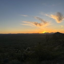
This needn't be verbose to get this across. This is the nation's largest city park. It is larger than Manhattan!! The park may as well be infinite. I know no person who has trecked all the trails in the park. I use the free app All Trails. You can sort by rating, difficulty, vertical climb, length etc. Just plug in what you're in the mood to do today and BAM!! Off you go and you can literally do a new route every day of your life and not repeat! There are that many permutations. There are a dozen places to park around the mountain and look up 'silent Sundays ' when the central Ave road is closed to traffic. You can bike or skateboard the whole way to the summit without worrying about cars! I did that with a bike and a baby trailer 10 years ago and every time I see that beloved mountain I think about it. Wear a helmet, bring water (and turn around BEFORE halfway empty) and download your podcast or music prior. Lots of no cell service areas. Enjoy!!
 and Wrigley (tricolor coat) in the wash after climbing up and back down Marcos de Niza.")
I never even knew that South Mountain extended this far, basically the Guadalupe/Ahwatukee border. A coworker showed me this area and it has quickly become one of my favorite places to hike. Living in South Tempe, I am able to get home after work and grab my pups and be hiking in minutes. I love the Marcos de Niza trail, it's a great trail that has awesome views of the entire East Valley from Downtown Phoenix to Apache Junction. You could see freaking Lost Dutchman from there on a clear day. My dogs love the trail, they know it better than me. It's lightly trafficked to compared to other South Mountain trails, the wash gets a little hairy sometimes when the mountain bikers are coming down in groups - but more often than not they are considerate (except for a few outliers). To me, as someone who loves hiking at Lost Dutchman and Sedona, this is a gem given how close it is to my house. I recommend coming here and finding a trail you love and just going as often as you can, especially if you live in Tempe, Guadalupe or Ahwatukee.

I love this place!! It's my favorite place to hike. Easy to moderate-ish trails. Some are uphill and a little rocky. Cool look out points. I've spotted a coyote, a snake, lots of lizards, and chipmunks while hiking. I love that it's a beautiful piece of nature tucked away amidst the city. Bring water. Wear sunscreen and don't litter. Also, please don't stray from the designated trails because it destroys the fauna. Wear hiking shoes with a lot of tread. Also, there's a lot of bikers on the trails, but they're usually really courteous.

How bad can the great outdoors be??? I love hiking here. Parking is a bit crazy on weekends so if you plan to park here, come early. (I park in a nearby neighborhood to avoid the jam.) There are miles of great trails from challenging to easy does it! There a trail map near restrooms. The restroom is usually pretty clean and maintained. They also have nice covered picnic benches and tables for resting, dining or just hanging out. It is dog friendly park however leash laws are in order here. A word to those who plan to hike here, there is NO trash pick up on trails so please, please take your trash including dog poop bags out with you to trash cans at parking lot. I get so upset (I'm keeping my language clean lol) when I see bags and trash along the trails!!! Enjoy the trails my friends! What a great way to stay healthy!

OUTSTANDING SPOT FOR HIKING! Lots of Parking Availability, Nice Bathrooms, Well Maintained and Clean Park! No Entrance or Parking Fees! There are quite a few trails to go hiking and exploring on. The city of Phoenix has been making lots of improvements to this park as well which is AWESOME! This is my favorite Phoenix park! It's located down a residential area that if you were not looking for this park, you would likely never know of its existence. But what a shame that would be! Points of interest would be Fat Mans Pass (You cannot be fat and fit through this crack!) and natural tunnel?... Great pictures and great little 6 mile roundtrip hike to do them at the same time. I haven't done all the hikes yet, but National Trail is great and has a nice spot to hang out on top of the mountain and watch airplanes take off from the Phoenix Airport... Don't miss this GEM!

3 months ago


This has been a go-to hike for more than twenty-plus years. I used to take my kids when they were as young as five years old. It's a great place to go walking or hiking for the day. It's a desert Oasis, not far from the city. The trails are easy enough to navigate, and there's plenty to look at--just look at my pictures. There are restrooms and free parking - sometimes you do have to walk a bit to the trail and no admission fee to get in! It's a perfect place to walk, look at nature or mountain bike. No fees Restrooms On-site Dogs welcome read more


7 months ago
I've been here a couple times for short hikes and recently went back and walked the whole Pima canyon loop with my son. I believe it was a 3 mile hike. I will say I was as not prepared as I should have been with bringing extra fluids. I figured I'd hydrated enough before leaving home, so only brought about 16 ounces of water in my 320z bottle. I'm a newbie and come from flat lands , Texas and Florida most recently. I'm not in my best shape and gained some unexpected late 40's weight so I'm very proud that I survived that hike and noticed a 20 year old amateur like myself being challenged in completing the loop also. Next time I will take it nice and slow , bask in the beauty now that I know the trail and I'm not about to have a Netflix special airing about my demise in the mountains! Lol., if you haven't been here and want to get into hiking as a beginner like myself, I highly recommend going here. It's right off 48th in a beautiful neighborhood. Takes me 5 minutes to drive here from my place. I feel so blessed to be close to something so amazingly beautiful and free while benefiting my health. Being out there among other healthy minded people makes me even more motivated. read more

Being that the weather is PERFECT in Phoenix right now I wanted to finally take off and explore more of Arizona and take my toddler, now that she can do so. I did some research and checked out a few trails for an "easy" trail that is kid friendly and came upon Pima Canyon Trail. We went early evening and it was pretty busy but there was still a decent amount of parking. As you can see, my little one was excited and ready to explore. The trail is very gradual, a bit rocky but easy to navigate. There are a ton of bicyclists so it is best to stick to one side to allow them and faster hikers to pass. The trail takes about an hour to complete. The scenery is beautiful and who can't use a little fresh air? I did notice almost everyone there was smiling and friendly as we passed, a sign to hike more often:) There are restrooms, a water station and maps. Do be sure to check the hours, as it is located off the golf course and in a gated area. read more


2 years ago
My go-to hiking trail with a good warm-up that's flat with some rocks and incline. Lots of space to walk past others and even plenty of mountain bikers. Very pet friendly, and as you get to the "red bench," then you have a few chose your adventure types of paths. National trail is definitely challenging, and paths get smaller, tighter, and higher. There is plenty of parking on and off peak times. Great views of the city, easy, moderate, and difficult paths for everyone... even horses. read more


5 years ago
This review is for the Pima Canyon Trailhead location off of 48th St. The entrance is near the Rustler's Rooste mountaintop restaurant. This is a hike that I do quite regularly because it is so close to the I-10 and where I live. What I like about it is all the trail options you have. They have a variety of easy to more difficult trails to choose from. There are trail runners, mountain bikers, hikers and people that just want to go for a stroll at this location. Parking isn't bad on the weekdays but can be a real pain on the weekends. Especially during the coolers weather. They built some nice clean bathrooms a few years back at the entrance. There are also some tables with shade that make for a nice spot to meet up with people. The National Trail is is pretty easy and goes for quite a distance. There are several trails that you can access from the National Trail. This is where you see most people walking. The Desert Classic Trail is to the left and goes for about 9 miles. The Marcos De Niza Trail is pretty fun and gives you some great views of both sides of the Valley. The Pima Loop Trails (East and West) and the Ridgeline Trail can be accessed from the Pima Wash Trail to the right. Further down the National Trail you can access Hidden Valley Trail (where they have a natural tunnel you can go through) and Mormon Trail. Fat Man's Pass (a narrow passage between two boulders) is located on the Mormon Trail. There are so many more trails beyond these you can explore. Unfortunately we do get lots of visitors who underestimate our hotter months and don't bring enough water or try to hike in the late afternoons. They do extend the hours during the summer so you can hike earlier. Another thing that sucks is people who bring their dogs and don't pick up their mess. Speaking of dogs, they are prohibited on Phoenix hiking trails when the temperature is 100 degrees or warmer. And keep in mind, this is the desert. I have only seen one snake on this mountain, but do watch out for them even though it's rare to see them. Overall this mountain has tons of options and makes for a nice day out. read more


A fun, family-friendly trail system in Phoenix. One of the cool things about Arizona hiking trails compared to California trails are the lack of people with Bluetooth speakers blasting offensive rap music while hiking. Even though this trail system is very crowded, the people dissipate the farther you hike. If you make it to the hidden valley, you'll enjoy great views of the city and see two unique natural features. Things to see - 1. Fat Man's pAss - It's a tight fit through two rock walls. Looks a lot tighter than it actually is. Most people can squeeze through it. 2. Hidden Valley Natural tunnel - Yes it's a tunnel but the real "cool factor" will be the large boulders behind the tunnel. Your kids will spend an hour climbing around. Family Tip - Watch out for mountain bikers zooming down the trail. Make sure everyone stays to the right side in a single file. Hiking Tip - If you're really looking for a good hike start hiking from the parking lot, take the national trail to the Hidden Valley Loop (Fat Man's Ass and Hidden Valley Tunnel) then take the unmarked path to the Midlife Crisis trail (top of the small mountain) and head north back to the parking lot along the ridgeline. You'll probably need to open google maps and have GPS on, but on the map you will see the trail ( a little bit past the tunnel) to get you to the Midlife Crisis ridgeline trail. Follow the trail north. The trail changes names to the "Scott Ridge Trail" on the map. From there keeping heading north (it runs parallel to the National Trail) and go all the way back to the parking lot. read more


3 years ago
Great trails and good for the pups and families. Bathrooms, soap and water and water station. Lots of parking and lots of people but never felt crowded and this was on a gorgeous Sunday afternoon! Looking forward to returning soon! read more

Terrific desert hiking trails conveniently located close to Tempe, AZ. Lots of trails and mountains branch off a main wide trail. I only hiked a fraction of this park. And I've seen pictures of trails further in, such as fat man's pass, it looks remarkable! But I really enjoyed my early morning hike in here. Climbing up the first mountain on the left upon entering, it was refreshingly more rugged than I expected but very enjoyable and exhilarating! And it didn't take more than 15 to 20 minutes to get to the top of this smaller peak, A great little side hike! After coming down this mountain, I returned to the main trail which goes right between a bunch of mountains on the ground level. I can see other trails running parallel off to my right side, with joggers and other groups exploring those. Mountain biking here is common as well. Really a great place to go if you're looking to do some easily accessible hiking. The fauna at least near the entrance to the park, wasn't the best I've seen. But it definitely was good, solid desert terrain and enjoyable. I explored a few other side trails and hills. Overall I liked it so much I plan to go back there the next day, especially since it's closer to my hotel then other favorites like Camelback Mountain and Tom Thumb mountain. Just a warning, during 2017 they are doing construction at the entrance to this park. They make you park a half a mile away from the trailhead, which is inconvenient. You spend your first half mile of your hike walking down the access road to get to the trailhead. But besides that, it was a very exciting experience. Definitely recommended for hiking in the Tempe, AZ area. read more


One of my favorite hiking spots. This is a classic hiking, mountain biking, equestrian and trail runners paradise. This enterance is Super busy especially durring the weekend. Note if you haven't ever hiked here the South Mountain Preserve is about 50 square miles. Be sure to you have a plan and know what trail you are on and where you are going. Mountain Biking is popular so listen for a kind ring of a bell or a ....on your left....meaning you.... your family of five and your leashed dog all need to make room. For people who hike and bike you get it. There are trails for every level. Slow and steady, thigh burning grinds and everything in between. read more

My first time ever hiking. Visiting from Florida, this was an Awesome beginners hike, since I have never been. While visiting my ex-sister-in law she wanted to take us near her home to explore the beauty of Arizona. The parking lot around the mountain was open and available at the time we went in the morning and close to the trails. The trails were very accessible with clear paths to walk. We carefully walked up the mountain with ease. While walking on the trail you could see the historic areas to look at. The view was breathtaking for the scenery it provided. The weather was hot walking up the trail, but when we go to the top the breeze and scenery made it worth it. This park has bathroom stalls that were very clean. I had a great time with family and friends getting to this part of Arizona. This is a must. read more


This needn't be verbose to get this across. This is the nation's largest city park. It is larger than Manhattan!! The park may as well be infinite. I know no person who has trecked all the trails in the park. I use the free app All Trails. You can sort by rating, difficulty, vertical climb, length etc. Just plug in what you're in the mood to do today and BAM!! Off you go and you can literally do a new route every day of your life and not repeat! There are that many permutations. There are a dozen places to park around the mountain and look up 'silent Sundays ' when the central Ave road is closed to traffic. You can bike or skateboard the whole way to the summit without worrying about cars! I did that with a bike and a baby trailer 10 years ago and every time I see that beloved mountain I think about it. Wear a helmet, bring water (and turn around BEFORE halfway empty) and download your podcast or music prior. Lots of no cell service areas. Enjoy!! read more


) is 20 yards away! - Hiking Near Me - Phoenix, Arizona")


I never even knew that South Mountain extended this far, basically the Guadalupe/Ahwatukee border. A coworker showed me this area and it has quickly become one of my favorite places to hike. Living in South Tempe, I am able to get home after work and grab my pups and be hiking in minutes. I love the Marcos de Niza trail, it's a great trail that has awesome views of the entire East Valley from Downtown Phoenix to Apache Junction. You could see freaking Lost Dutchman from there on a clear day. My dogs love the trail, they know it better than me. It's lightly trafficked to compared to other South Mountain trails, the wash gets a little hairy sometimes when the mountain bikers are coming down in groups - but more often than not they are considerate (except for a few outliers). To me, as someone who loves hiking at Lost Dutchman and Sedona, this is a gem given how close it is to my house. I recommend coming here and finding a trail you love and just going as often as you can, especially if you live in Tempe, Guadalupe or Ahwatukee. read more
 and Wrigley (tricolor coat) in the wash after climbing up and back down Marcos de Niza. - Hiking Near Me - Phoenix, Arizona")
 and Fenway (black coat) at the top of one of the ridges on Marcos de Niza trail. - Hiking Near Me - Phoenix, Arizona")
4 years ago
I love this place!! It's my favorite place to hike. Easy to moderate-ish trails. Some are uphill and a little rocky. Cool look out points. I've spotted a coyote, a snake, lots of lizards, and chipmunks while hiking. I love that it's a beautiful piece of nature tucked away amidst the city. Bring water. Wear sunscreen and don't litter. Also, please don't stray from the designated trails because it destroys the fauna. Wear hiking shoes with a lot of tread. Also, there's a lot of bikers on the trails, but they're usually really courteous. read more


How bad can the great outdoors be??? I love hiking here. Parking is a bit crazy on weekends so if you plan to park here, come early. (I park in a nearby neighborhood to avoid the jam.) There are miles of great trails from challenging to easy does it! There a trail map near restrooms. The restroom is usually pretty clean and maintained. They also have nice covered picnic benches and tables for resting, dining or just hanging out. It is dog friendly park however leash laws are in order here. A word to those who plan to hike here, there is NO trash pick up on trails so please, please take your trash including dog poop bags out with you to trash cans at parking lot. I get so upset (I'm keeping my language clean lol) when I see bags and trash along the trails!!! Enjoy the trails my friends! What a great way to stay healthy! read more


8 years ago
OUTSTANDING SPOT FOR HIKING! Lots of Parking Availability, Nice Bathrooms, Well Maintained and Clean Park! No Entrance or Parking Fees! There are quite a few trails to go hiking and exploring on. The city of Phoenix has been making lots of improvements to this park as well which is AWESOME! This is my favorite Phoenix park! It's located down a residential area that if you were not looking for this park, you would likely never know of its existence. But what a shame that would be! Points of interest would be Fat Mans Pass (You cannot be fat and fit through this crack!) and natural tunnel?... Great pictures and great little 6 mile roundtrip hike to do them at the same time. I haven't done all the hikes yet, but National Trail is great and has a nice spot to hang out on top of the mountain and watch airplanes take off from the Phoenix Airport... Don't miss this GEM! read more


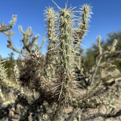
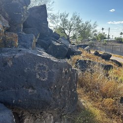
FYI...make sure you arrive early. Regardless of the amount of parking this trailhead is always busy. It's really the springboard for a lot of the eastern trails in the park so there a lot of options depending on your skill level and desire. The wash trail is fairly flat for a mile or so and that means lots of mountain bikes and families with their dogs. Once you reach the Army Corps of Engineer stone structures is where the real excitement begins. Look for petroglyphs, wildlife, and blooming flora. read more


Lots of hiking trails to choose from here at Pima Canyon! Make sure you get a map online so you don't get lost! The trails here are windy and they cross and overlap everywhere. We took the trail that led us to National Trail that took us to Hidden Valley Trail to Fat Man's Pass. The total hike was about 6 miles round trip. The first part is kind of paved then turns into dirt. You pass the houses made out of rock once you get to the end of the trail. If you want to keep going you go to the right where the sign and the map are. There are several trails that go to the left or straight and there are signs and arrows. Hidden Valley and Fat Man's Pass are my favorite spots here. Great photos and unique rock formations. read more


I asked friend to take me on a near by "easy" trail that I could get my feet wet in "hiking." Let me just say the climb was well worth the view! I will say what is easy to one person may be challenging to another person as there are plenty of peaks on this trail head. I love the view from the top! I was pleasantly surprised that the trail was so well maintained and easy to walk, with consideration it's mostly rock. The weather today was mild and perfect for climb. The parking around the trail was ample and very open with close proximity to start of multiple access points. I did also use the bathrooms which were clean and accessible before you start your hike. I counted 6 stalls with hand washing station outside of bathrooms. Across from the bathrooms there was signage of history of trail with maps for different access points. I would highly recommend this trail with WATER to carry along with you. I got good work out in and witness some amazing views of Phoenix, South Phoenix and Tempe! Please put this one on your to do list for city's hiking trails read more


6 years ago
6 years ago
If you are into hiking (just starting or expert) this place is simply amazing! Enough trails to keep you preoccupied for many visits! Parking can be difficult at the base (especially when weather is amazing) so look for some places nearby to park. Also, take a moment to download All Trails as that has helped me navigate the many intersecting trails and list the completed trails in a nice list. Beautiful scenery, wildlife, and a great way to get some amazing shots! read more

9 years ago
I came here today, a Saturday, it was dry and rocky. Great exercise, a lot of different trails you can take and there are signs and it's easy to follow the path. I wore my Merrell Vapor Glove shoes so I can feel all the rocks beneath me. Seems safe to go a lone, since it's next to a golf course and it seems like a popular hiking trail. Got some great scenic photos while I was here, check it out! I didn't finish the hike since I was only looking to hike for 45 minutes, it I'll work my way up next time. read more


8 years ago
Just started exploring this trail but it is so pretty and peaceful! There are tons of different trails you can take with great views of the city! read more


This easy moderate trail has more gradual inclines compared to the end of Telegraph trail on South Mountain, which I prefer. Flat and wider paths makes Pima Wash dog friendly, which we saw many of yesterday. From one of the peaks you can see west of downtown PHX to south of Chandler. Nice photo ops all along the way! read more


7 years ago
Great place to hike with alot of different trail options. We hiked the Desert Classic and the National trail. Turned out to be about 11 mile loop and it was beautiful. Friendly people, clean restrooms, water bottle refill spigot, free parking and access. We are from Seattle and love hiking here in the desert. Most local mountain bike riders were courteous, some did not yield to hikers which have the right of way. read more


8 years ago
This is the first hiking place I've been to. Visited twice the first time we couldn't go past the first mountain because my boyfriend is afraid of heights. But I went back with some friends and it was a good time. It's a bunch of small to medium mountains you can go around or go over as many as you want and then go back. It's like a roller coaster of mountains. I like it it's a good Saturday morning workout instead of hitting the gym. They have a restroom and water fountains (never used) but it's a good visit for first time hikers or just a way to get your blood flowing. I haven't been to other mountains yet so I can't say if this is the best or worst but I enjoy going. read more


8 years ago
From San Diego, exploring PHX. After a few searches, this location came up for Mountain Biking. The trail in particular i'm going to talk about is Desert Classic (DC) Trail... Foodie in me likes to think of it as Dessert Classic. I would consider this trail to be great for beginners. The trails are clearly marked with signs and arrows "DC". For the first 7 miles if you are doing the out and back from Pima Canyon South Entrance - it's Basic/Beginner. The 7-8 can be moderately technical, so you will run into this when you come back. Trail flows very well, wide enough for 2 way and hiking traffic. It can be fast, with rolling drop/climbs from the washes from time to time. I would recommend going early if its warm out and fill your water carrier to the max. There is really no shade here so expect to be exposed the entire ride. Terrain varies from packed, loose, gravel, and rock gardens more between mile 6-12. It's nice because there is no excessive climbs - mild descend and climbs in averaging in 2% range. On a Saturday morning around 8am (~80degrees), until we returned around 10am (95degrees) in first week of May - however with a heat wave 2018. We still crossed paths with a few people, not a lot that i would say its crowded - but enough to get help if you needed it haha. I know there are other more advanced trails that branch of from DC that i'd like to visit next time we're in town. Parking lot isn't that large, but there is one side street parking on the entrance. Tons of open space that look to be good for exploring either HIKE or BIKE - Cheers and Have fun! read more


7 years ago
5 years ago
One of our favourite places to hike when we're in Phoenix. From this location you have access to dozens of trails. National trail, Mormon trail, Fat Man's pass, Ridgeline are some of our favourites. If you want to go to Fat Man's pass, take National Trail to Hidden Valley then take Mormon Loop back to Pima Canyon Trailhead- in total about 11KM's(6.83 miles) - a beautiful hike with exposure to beautiful views of downtown Phoenix, amazing rock formations and old stone buildings. read more


This park is the perfect escape if you are staying in Tempe and are tired of the hotel gym (I'm sure it's great for locals as well). One of the largest urban parks in the US, there are numerous trails of varying lengths for all abilities. The West and East loop lead to ridge runs/hikes which bring you high above the valley. The Mormon loop is more challenging but the fauna is worth the time. The desert classic trail can be easy or you can choose to go a little higher into the hills. Parking can get tough (despite the many, many spaces) later in the day. Bring water or a bottle (you can fill it from the fountain at the trail head). The trails are well marked, but if you are easily confused scan the trail maps at the parking lot. Public bathrooms at the entrance to trails. No entrance fee. read more


9 years ago
We did Pima! Climbed up rocks and climbed down narrow trails. Very challenging but rewarding once you completely finish read more


7 years ago

10 years ago
Hiking here was the best part of my week in the area. Great views. Great workout. You can keep it easy on the main path or challenge yourself by heading off other paths and up with he mountains. Remember to pack water and sunscreen. Tennis shoes are a must, hiking boots would be even better. Walking stick is a good idea. read more

Page 1 of 2
More info about Pima Canyon South Mountain
9904 S 48th St
Phoenix, AZ 85044
Directions
Hours
Indoor Amenities
Outdoor Amenities
Ask the Community - Pima Canyon South Mountain
Review Highlights - Pima Canyon South Mountain
You might also consider


Why does Yelp recommend reviews?
Pima Canyon South Mountain - hiking - Updated May 2026
Best of Phoenix
People found Pima Canyon South Mountain by searching for…
Hiking Trails With Waterfalls in Phoenix, AZ
Scenic Night View in Phoenix, AZ
Dog Friendly Beaches in Phoenix, AZ
Dog Friendly Parks in Phoenix, AZ
Off Road Trails in Phoenix, AZ
Beautiful Views in Phoenix, AZ
Dog Friendly Hiking Trails in Phoenix, AZ
Places to Walk at Night in Phoenix, AZ
Trending Searches in Phoenix, AZ
Boat Rental near Pima Canyon South Mountain
Botanical Gardens near Pima Canyon South Mountain
Bounce House Rentals near Pima Canyon South Mountain
Campgrounds near Pima Canyon South Mountain
Cheap Plants near Pima Canyon South Mountain
Cherry Picking near Pima Canyon South Mountain
Cliff Jumping near Pima Canyon South Mountain
Flower Fields near Pima Canyon South Mountain
Flower Shop near Pima Canyon South Mountain
Garage Sales near Pima Canyon South Mountain
Garden Center near Pima Canyon South Mountain
Lakes & Ponds near Pima Canyon South Mountain
Nurseries & Gardening near Pima Canyon South Mountain
Outdoor Activities near Pima Canyon South Mountain
Outdoor Furniture Stores near Pima Canyon South Mountain
Parks near Pima Canyon South Mountain
Party Equipment Rentals near Pima Canyon South Mountain
Pedicure near Pima Canyon South Mountain
Photo Spots near Pima Canyon South Mountain
Picnic Areas near Pima Canyon South Mountain
Places To Take Pictures near Pima Canyon South Mountain
Rock Quarry near Pima Canyon South Mountain
Running Trails near Pima Canyon South Mountain
Rv Rental near Pima Canyon South Mountain
Scenic Drive near Pima Canyon South Mountain
Sunrise View near Pima Canyon South Mountain
Swimming Holes near Pima Canyon South Mountain
Table And Chair Rentals near Pima Canyon South Mountain
Browse Articles
Browse Nearby
BEST of Phoenix, Arizona Coffee near Pima Canyon South Mountain
BEST of Phoenix, Arizona Things to Do near Pima Canyon South Mountain
BEST of Phoenix, Arizona Restaurants near Pima Canyon South Mountain
BEST of Phoenix, Arizona Scenic View near Pima Canyon South Mountain
BEST of Phoenix, Arizona Breakfast near Pima Canyon South Mountain
BEST of Phoenix, Arizona Parks near Pima Canyon South Mountain
BEST of Phoenix, Arizona Hotels near Pima Canyon South Mountain
BEST of Phoenix, Arizona Airport near Pima Canyon South Mountain
Browse Brands
Related Searches in Phoenix, AZ
Affordable Kayak Rental Services in Phoenix, Arizona
Best Fishing Locations and Guides in Phoenix, Arizona
Best Nature Trails for Hiking in Phoenix, Arizona
Best Places for Horseback Riding in Phoenix, Arizona
Best Waterfalls and Swimming Holes in Phoenix, Arizona
Check Out Off Road Trails in Phoenix, Arizona
Discover Dog Friendly Trails to Explore in Phoenix, Arizona
Discover Kid Friendly Hiking Trails in Phoenix, Arizona
Discover Scenic Hiking Trails in Phoenix, Arizona
Discover Scenic Mountain Bike Trails Near Phoenix, Arizona
Discover Scenic Walking Paths in Phoenix, Arizona
Discover Scenic Waterfall Spots in Phoenix, Arizona
Discover Top Nature Parks to Visit in Phoenix, Arizona
Discover Walking Parks in Phoenix, Arizona Near You
Discover the Best Night Hike Trails in Phoenix, Arizona
Discover the Best Running Track in Phoenix, Arizona
Dog-Friendly Hikes With Dogs in Phoenix, Arizona
Enjoy Camping Adventures Around Phoenix, Arizona
Enjoy Exciting Mountain Biking Adventures in Phoenix, Arizona
Enjoy Kayaking Adventures in Phoenix, Arizona
Enjoy Tent Camping Spots Around Phoenix, Arizona
Enjoy a Beautiful Waterfall Hike in Phoenix, Arizona
Enjoy a Scenic Walk in Phoenix, Arizona
Enjoy the Best Walking Trails in Phoenix, Arizona
Exciting Cliff Jumping Spots in Phoenix, Arizona
Experience Thrilling White Water Rafting in Phoenix, Arizona
Explore Beautiful Parks and Green Spaces in Phoenix, Arizona
Explore Easy Hikes Perfect for All in Phoenix, Arizona
Explore Fun Activities to Do in Phoenix, Arizona
Explore Popular Campgrounds Near Phoenix, Arizona
Explore the Best Beach Spots in Phoenix, Arizona
Explore the Best Trail Options in Phoenix, Arizona
Family Friendly Hiking With Kids in Phoenix, Arizona
Find Beautiful Views in Phoenix, Arizona
Find the Best Parks for Picnics in Phoenix, Arizona
Find the Best Scenic View Locations in Phoenix, Arizona
Hiking Trails With Waterfalls in Phoenix, Arizona
Off Leash Dog Hiking Trails in Phoenix, Arizona
Plan a Scenic Drive Route Near Phoenix, Arizona
Popular Fishing Spots to Explore in Phoenix, Arizona
Popular Outdoor Activities to Try in Phoenix, Arizona
Popular Picnic Spots to Visit in Phoenix, Arizona
Safe River Swimming Areas in Phoenix, Arizona
Safe and Fun Parks for Kids in Phoenix, Arizona
Top Climbing Spots and Gyms in Phoenix, Arizona
Top Running Trails to Explore in Phoenix, Arizona
Top Swimming Lakes to Enjoy in Phoenix, Arizona
Top Swimming Spots and Pools in Phoenix, Arizona