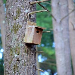
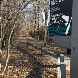
Phenix-Harris River Walk Photos


You might also consider
More like Phenix-Harris River Walk
Recommended Reviews - Phenix-Harris River Walk
Start your review...

I run through this small river walk to add some scenery to my jogs around the neighborhood. I'll opt to take this- maybe 500 foot long pathway as opposed to the street. This is certainly not a hiking trail or anything worth driving out of the way for. If you find yourself for whatever reason strolling through the area it is not far out of the way for a quick walk. read more

11 years ago
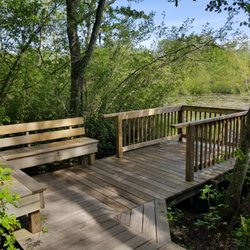
Railroads rivers and ivy The Phenix-Harris River Walk is a hiking and biking path that was constructed along an old rail road bed. It follows the Pawtuxet River and eventually will be connected to other short hiking trails to form a much longer one. The walk is short and flat, probably only a little more than a half mile but hopefully one day will be much longer when it is connected to the other paths. It's a pleasant little walk in the winter and is a decent place for some easy cross country skiing. It the spring and summer the bugs are quite bad and the path is infested with some very healthy poison ivy. You definitely have to be careful where you step. Certainly not the most exciting path but at least the Pawtuxet River does seem to be cleaner than it was a decade ago. Once the walk is connected to a few other paths in the area it will be an interesting walk along a river right in the middle of a congested and developed urban area. read more


7 years ago
More info about Phenix-Harris River Walk
Fairview Ave
West Warwick, RI 02893
Directions
Hours
Outdoor Amenities


Phenix-Harris River Walk - hiking - Updated July 2026
Best of West Warwick
People found Phenix-Harris River Walk by searching for…
Walking Trails in West Warwick, RI
Hiking Trails in West Warwick, RI
Things to Do With Kids in West Warwick, RI
Running Trails in West Warwick, RI
Bike Paths in West Warwick, RI
Dog Friendly Trails in West Warwick, RI
Easy Hikes in West Warwick, RI
River Walk in West Warwick, RI
Fun Things to Do at Night in West Warwick, RI
Waterfalls in West Warwick, RI
Scenic View in West Warwick, RI
Fall Foliage in West Warwick, RI
Stroller Friendly Hikes in West Warwick, RI
Free Things to Do in West Warwick, RI
Stuff to Do in West Warwick, RI
Hiking With Kids in West Warwick, RI
Fun Things to Do for Adults in West Warwick, RI
Public Swimming Pools in West Warwick, RI
Walking Path in West Warwick, RI
Nature Walks in West Warwick, RI
Watch Sunset in West Warwick, RI
Browse Nearby
BEST of West Warwick, Rhode Island Restaurants near Phenix-Harris River Walk
BEST of West Warwick, Rhode Island Coffee near Phenix-Harris River Walk
BEST of West Warwick, Rhode Island Things to Do near Phenix-Harris River Walk
BEST of West Warwick, Rhode Island Parks near Phenix-Harris River Walk
BEST of West Warwick, Rhode Island Breakfast near Phenix-Harris River Walk
BEST of West Warwick, Rhode Island Shopping near Phenix-Harris River Walk
Browse Brands
Browse Articles
People who viewed Phenix-Harris River Walk also viewed
East Greenwich Nature Trail
3 reviews
Breakheart Trail
3 reviews
John H Chafee Nature Preserve
17 reviews
Sandy Acres Recreation Area
3 reviews
Stillwater Scenic Trail
4 reviews
Bleachery Woods Trail
2 reviews
Davis Memorial Wildlife Refuge
3 reviews
Veterans Memorial Park
3 reviews
Godena Farm
2 reviews
Calf Pasture Point Beach
2 reviews