Phenix-Harris Riverwalk Photos


You might also consider
More like Phenix-Harris Riverwalk
Recommended Reviews - Phenix-Harris Riverwalk
Start your review...

2 years ago
2 years ago
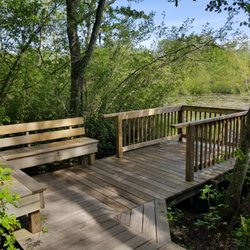
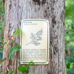
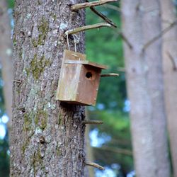
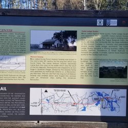
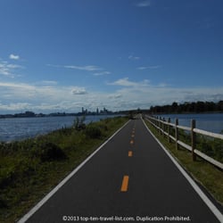
I run through this small river walk to add some scenery to my jogs around the neighborhood. I'll opt to take this- maybe 500 foot long pathway as opposed to the street. This is certainly not a hiking trail or anything worth driving out of the way for. If you find yourself for whatever reason strolling through the area it is not far out of the way for a quick walk. read more
More info about Phenix-Harris Riverwalk
Coventry, RI 02816
Directions
Hours
Outdoor Amenities


Phenix-Harris Riverwalk - hiking - Updated July 2026
Best of Coventry
People found Phenix-Harris Riverwalk by searching for…
Walking Trails in Coventry, RI
Running Trails in Coventry, RI
Dog Friendly Trails in Coventry, RI
Mountain Biking in Coventry, RI
Free Things to Do in Coventry, RI
Fun Things to Do in Coventry, RI
Stroller Friendly Hikes in Coventry, RI
Public Swimming Pools in Coventry, RI
Things to Do With Teenagers in Coventry, RI
Trending Searches in Coventry, RI
Blueberry Picking near Phenix-Harris Riverwalk
Boat Tours near Phenix-Harris Riverwalk
Cliff Jumping near Phenix-Harris Riverwalk
Cruising Spots near Phenix-Harris Riverwalk
Day Trips near Phenix-Harris Riverwalk
Dog Friendly Things To Do near Phenix-Harris Riverwalk
Jet Ski Rental near Phenix-Harris Riverwalk
Kayak Rental near Phenix-Harris Riverwalk
Kids Activities Indoor near Phenix-Harris Riverwalk
Lakes near Phenix-Harris Riverwalk
Off Road Trails near Phenix-Harris Riverwalk
Outdoor Activities near Phenix-Harris Riverwalk
Peach Picking near Phenix-Harris Riverwalk
Picnic near Phenix-Harris Riverwalk
Places To Walk Around near Phenix-Harris Riverwalk
Public Shower near Phenix-Harris Riverwalk
River Swimming near Phenix-Harris Riverwalk
Rock Quarry near Phenix-Harris Riverwalk
Scenic Overlook near Phenix-Harris Riverwalk
Surf Shop near Phenix-Harris Riverwalk
Swimming Holes near Phenix-Harris Riverwalk
Swimming Lakes near Phenix-Harris Riverwalk
Things To Do On A Rainy Day near Phenix-Harris Riverwalk
Tubing near Phenix-Harris Riverwalk
View Points near Phenix-Harris Riverwalk
Watch Sunset near Phenix-Harris Riverwalk
Browse Articles
Browse Nearby
BEST of Coventry, Rhode Island Restaurants near Phenix-Harris Riverwalk
BEST of Coventry, Rhode Island Coffee near Phenix-Harris Riverwalk
BEST of Coventry, Rhode Island Things to Do near Phenix-Harris Riverwalk
BEST of Coventry, Rhode Island Parks near Phenix-Harris Riverwalk
BEST of Coventry, Rhode Island Breakfast near Phenix-Harris Riverwalk
BEST of Coventry, Rhode Island Shopping near Phenix-Harris Riverwalk
Browse Brands
Related Searches in Coventry, RI
Affordable Kayak Rental Services in Coventry, Rhode Island
Best Dog Hiking Trails Around Coventry, Rhode Island
Best Fishing Locations and Guides in Coventry, Rhode Island
Best Places for Horseback Riding in Coventry, Rhode Island
Best Sightseeing Experiences Available in Coventry, Rhode Island
Best Waterfalls and Swimming Holes in Coventry, Rhode Island
Check Out Off Road Trails in Coventry, Rhode Island
Discover Dog Friendly Trails to Explore in Coventry, Rhode Island
Discover Kid Friendly Hiking Trails in Coventry, Rhode Island
Discover Popular Bike Trails in Coventry, Rhode Island
Discover Scenic Mountain Bike Trails Near Coventry, Rhode Island
Discover a Hiking Trail in Coventry, Rhode Island
Discover the Best Night Hike Trails in Coventry, Rhode Island
Dog-Friendly Hikes With Dogs in Coventry, Rhode Island
Enjoy Camping Adventures Around Coventry, Rhode Island
Enjoy Kayaking Adventures in Coventry, Rhode Island
Enjoy Off Leash Dog Hikes in Coventry, Rhode Island
Enjoy Tent Camping Spots Around Coventry, Rhode Island
Enjoy a Beautiful Waterfall Hike in Coventry, Rhode Island
Enjoy the Best Picnic Spots and Ideas in Coventry, Rhode Island
Enjoy the Best Walking Trails in Coventry, Rhode Island
Experience Stunning Sunset Views in Coventry, Rhode Island
Explore Beautiful Parks and Green Spaces in Coventry, Rhode Island
Explore Easy Hikes Perfect for All in Coventry, Rhode Island
Explore Fun Activities to Do in Coventry, Rhode Island
Explore Popular Campgrounds Near Coventry, Rhode Island
Explore Top Dog Parks in Coventry, Rhode Island Near You
Explore the Best Beach Spots in Coventry, Rhode Island
Explore the Best Swimming Holes Around Coventry, Rhode Island
Family Friendly Hiking With Kids in Coventry, Rhode Island
Find Beautiful Views in Coventry, Rhode Island
Find Popular Ziplining Spots Around Coventry, Rhode Island
Find the Best Parks BBQ Grills in Coventry, Rhode Island
Find the Best Parks for Picnics in Coventry, Rhode Island
Find the Best Playgrounds to Visit in Coventry, Rhode Island
Hiking Trails With Waterfalls in Coventry, Rhode Island
Off Leash Dog Hiking Trails in Coventry, Rhode Island
Plan a Scenic Drive Route Near Coventry, Rhode Island
Popular Outdoor Activities to Try in Coventry, Rhode Island
Popular Picnic Spots to Visit in Coventry, Rhode Island
Safe River Swimming Areas in Coventry, Rhode Island
Safe and Fun Parks for Kids in Coventry, Rhode Island
Top Hiking Trails to Explore in Coventry, Rhode Island
Top Paddleboarding Activities in Coventry, Rhode Island
Top Playgrounds for Kids to Enjoy in Coventry, Rhode Island
Top Running Trails to Explore in Coventry, Rhode Island
Top Swimming Lakes to Enjoy in Coventry, Rhode Island
Top Swimming Spots and Pools in Coventry, Rhode Island


