Washington Secondary Bike Path Photos


You might also consider
More like Washington Secondary Bike Path
Recommended Reviews - Washington Secondary Bike Path
Start your review...

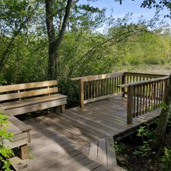
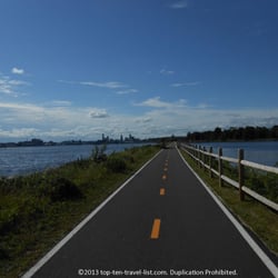
Started out today intending to take a short walk just to check out the path and how things are and whatnot. Expected to go to the first trail marker and turn around and come back. But I pulled a Forest Gump and I just kept running...well walking. Started at the Station Street parking lot and finished at the end of the path/trail at the Railroad Street parking lot. Roundtrip the route is about 15 miles and took me about 4.5 hours, with a couple brief stops along the way. The trail is very well maintained and surprisingly, everyone is cogent of the rules (walkers to the left, riders to the right). You pass by a baseball field, and there is a brook running alongside the trail at various points. Also along the way is a path to Flat River Tavern, and you also pass by an ice cream shop, so there are opportunities along the way for a respite in addition the park benches. Along the way there are also plenty of good views and vibe read more


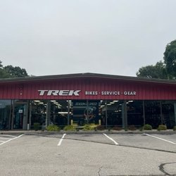
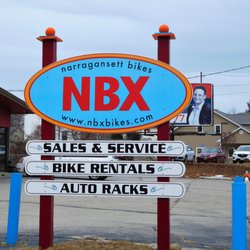
Begin from the parking lot located on either side of Station Street, in Coventry, RI, just past the Paine House Museum. If you choose to head east on the Greenway you cross two pedestrian bridges.The first goes over Rt. 117, the second over the south branch of the Pawtuxet River. This second bridge is close to a Trail parking lot on Pilgrim Avenue near Laurel Ave. The Greenway is part of the Washington Secondary Trail and has been designated as the area running through Coventry, RI. Taking this eastward route, you pass by several cemeteries on either side and a conservation area on your right. It is a mostly wooded area passing by a few back yards and has a gentle slope downward. History buffs can follow the path to the east from The Paine House Museum to the General Nathaniel Greene Homestead. Just exit the path at Laurel Avenue (just after the bridge over the Pawtuxet River) and follow Taft Street, just across Laurel Ave and to your right, to the homestead. It's about 3 miles round trip. Leaving Coventry, you can continue to walk east along the path, where you will meet up with Main Street in West Warwick. Here the path turns north then east, then north, then east again as it crosses the river, goes through some very populated areas, and continues through Cranston, RI. If you decide to head west on the path from the Station Street parking lots, you cross Rt. 117 at a crosswalk near a small shop where you can stop to grab a cool drink or ice cream. This way is also wooded, and passes a number of businesses before becoming quite rural. There is a small parking lot to access the trail located behind a new business on Rt. 117 (it's on Google maps) or continue further down the trail where you can also find a parking lot near the Coventry Public Library. If you are looking for a long walk under the trees, this is probably the direction you want to travel. If you love cemeteries and a shorter stroll, heading East could be for you. In either direction, the Coventry Greenway is a very nice section of the Washington Secondary Trail to get into nature without having to walk too far if you don't want to. We often grab the bikes and get in a nice long ride headed toward CT where the trail is renamed the Trestle Trail. It abruptly ends close to the CT line, just past the Summit General Store where you can get a cold drink and a sandwich if you've been on the trail for a while and need a snack. There is a parking lot at this end of the trail as well, but we warned, if you are riding a bike, the return trip to this lot is all up hill. I prefer to start at the other end and coast back. Enjoy! read more
 on the west side and Holden Street on the east side of this lot. - Hiking Near Me - COVENTRY, Rhode Island")
 signs dot the trail. - Hiking Near Me - COVENTRY, Rhode Island")
. - Hiking Near Me - COVENTRY, Rhode Island")
This bike path is long and great for bicycling. I used to bicycle from Coventry all the way to Providence when I was in high school. I now run or walk portions of the bike path especially in the fall to see the foliage. They have a parking lot in Coventry where you can bring bikes etc. There are no restrooms but there are businesses you could walk to on the side of the bike path to use the rest room. read more

15 years ago
Trains to bikes The Coventry Greenway is the most western most part of the paved bike path that now forms a 14.2 mile continuous path for bikers, walkers, skaters and runners. It opened last fall and it's addition now makes this the second longest bike path in Rhode Island, second only to the slightly longer East Bay Bike Path. This section has quite a variety of scenery, with ponds, woods and fields on it's western end contrasting with the more urban old mills and industrial dams toward the east. Lots of benches and places to stop for a drink or bite to eat along the way and some cool things, both natural and made made to look at. The west end connects into the yet unpaved Trestle Trail and heads off into the deeper woods. Eventually the Trestle Trail will be paved and extended all the way into Connecticut but as of right now it is suitable to only mountain bikes because of it's rough terrain. Still a great place to bike if you enjoy crashing, eatting dirt and get really muddy. The old railway was originally built back in 1840 and served the state well until finally closing for good in 1985. Rather than just letting it go to waste, putting it to use as a bike and walking path is a great idea. Old sections of tracks and switches were keep for historical reasons and many of the fences and barriers along the way were made from the recycled rail road ties. Eventually the idea is to link all the rail trails together to form one continuous path from the Connecticut border up through Providence into the Massachusetts. Although I have heard various reports of when they whole thing will be completed and of course getting the money is always a problem, work on paving the Trestle Trail might begin in the next few years. Progress is being made. read more


More info about Washington Secondary Bike Path


Why does Yelp recommend reviews?
1 review that is not currently recommended
The reviews below are not factored into the business's overall star rating.
6 years ago
Washington Secondary Bike Path - hiking - Updated August 2026
Best of COVENTRY
People found Washington Secondary Bike Path by searching for…
Basketball Courts in Coventry, RI
Walking Trails in Coventry, RI
Running Trails in Coventry, RI
Parks for Kids in Coventry, RI
Places to Take Pictures in Coventry, RI
Mountain Biking in Coventry, RI
Secluded Spots in Coventry, RI
Waterfall Hike in Coventry, RI
Jogging Trails in Coventry, RI
Swimming Lakes in Coventry, RI
Beautiful Views in Coventry, RI
Trending Searches in COVENTRY, RI
Blueberry Picking near Washington Secondary Bike Path
Boating near Washington Secondary Bike Path
Cinema near Washington Secondary Bike Path
Cliff Jumping near Washington Secondary Bike Path
Cruising Spots near Washington Secondary Bike Path
Day Trips near Washington Secondary Bike Path
Dog Friendly Things To Do near Washington Secondary Bike Path
Flower Fields near Washington Secondary Bike Path
Jet Ski Rental near Washington Secondary Bike Path
Kayak Rental near Washington Secondary Bike Path
Kids Activities Indoor near Washington Secondary Bike Path
Lakes near Washington Secondary Bike Path
Outdoor Activities near Washington Secondary Bike Path
Parks near Washington Secondary Bike Path
Peach Picking near Washington Secondary Bike Path
Picnic Areas near Washington Secondary Bike Path
River Swimming near Washington Secondary Bike Path
Rock Quarry near Washington Secondary Bike Path
Scenic Overlook near Washington Secondary Bike Path
Shopping Malls near Washington Secondary Bike Path
Sunrise View near Washington Secondary Bike Path
Surf Shop near Washington Secondary Bike Path
Swimming Holes near Washington Secondary Bike Path
Things To Do On A Rainy Day near Washington Secondary Bike Path
Watch Sunset near Washington Secondary Bike Path
Waterfalls And Swimming Holes near Washington Secondary Bike Path
Browse Articles
Browse Nearby
BEST of COVENTRY, Rhode Island Walking Trails near Washington Secondary Bike Path
BEST of COVENTRY, Rhode Island Restaurants near Washington Secondary Bike Path
BEST of COVENTRY, Rhode Island Coffee near Washington Secondary Bike Path
BEST of COVENTRY, Rhode Island Things to Do near Washington Secondary Bike Path
BEST of COVENTRY, Rhode Island Parks near Washington Secondary Bike Path
BEST of COVENTRY, Rhode Island Breakfast near Washington Secondary Bike Path
BEST of COVENTRY, Rhode Island Campgrounds near Washington Secondary Bike Path
BEST of COVENTRY, Rhode Island Sledding near Washington Secondary Bike Path
BEST of COVENTRY, Rhode Island Ski Resorts near Washington Secondary Bike Path
Browse Brands
Related Searches in COVENTRY, RI
Affordable Kayak Rental Services in Coventry, Rhode Island
Best Dog Hiking Trails Around Coventry, Rhode Island
Best Fishing Locations and Guides in Coventry, Rhode Island
Best Places for Horseback Riding in Coventry, Rhode Island
Best Sightseeing Experiences Available in Coventry, Rhode Island
Best Waterfalls and Swimming Holes in Coventry, Rhode Island
Check Out Off Road Trails in Coventry, Rhode Island
Discover Dog Friendly Trails to Explore in Coventry, Rhode Island
Discover Kid Friendly Hiking Trails in Coventry, Rhode Island
Discover Popular Bike Trails in Coventry, Rhode Island
Discover Scenic Mountain Bike Trails Near Coventry, Rhode Island
Discover a Hiking Trail in Coventry, Rhode Island
Discover the Best Night Hike Trails in Coventry, Rhode Island
Dog-Friendly Hikes With Dogs in Coventry, Rhode Island
Enjoy Camping Adventures Around Coventry, Rhode Island
Enjoy Kayaking Adventures in Coventry, Rhode Island
Enjoy Off Leash Dog Hikes in Coventry, Rhode Island
Enjoy Tent Camping Spots Around Coventry, Rhode Island
Enjoy a Beautiful Waterfall Hike in Coventry, Rhode Island
Enjoy the Best Picnic Spots and Ideas in Coventry, Rhode Island
Enjoy the Best Walking Trails in Coventry, Rhode Island
Experience Stunning Sunset Views in Coventry, Rhode Island
Explore Beautiful Parks and Green Spaces in Coventry, Rhode Island
Explore Easy Hikes Perfect for All in Coventry, Rhode Island
Explore Fun Activities to Do in Coventry, Rhode Island
Explore Popular Campgrounds Near Coventry, Rhode Island
Explore Top Dog Parks in Coventry, Rhode Island Near You
Explore the Best Beach Spots in Coventry, Rhode Island
Explore the Best Swimming Holes Around Coventry, Rhode Island
Family Friendly Hiking With Kids in Coventry, Rhode Island
Find Beautiful Views in Coventry, Rhode Island
Find Popular Ziplining Spots Around Coventry, Rhode Island
Find the Best Parks BBQ Grills in Coventry, Rhode Island
Find the Best Parks for Picnics in Coventry, Rhode Island
Find the Best Playgrounds to Visit in Coventry, Rhode Island
Hiking Trails With Waterfalls in Coventry, Rhode Island
Off Leash Dog Hiking Trails in Coventry, Rhode Island
Plan a Scenic Drive Route Near Coventry, Rhode Island
Popular Outdoor Activities to Try in Coventry, Rhode Island
Popular Picnic Spots to Visit in Coventry, Rhode Island
Safe River Swimming Areas in Coventry, Rhode Island
Safe and Fun Parks for Kids in Coventry, Rhode Island
Top Hiking Trails to Explore in Coventry, Rhode Island
Top Paddleboarding Activities in Coventry, Rhode Island
Top Playgrounds for Kids to Enjoy in Coventry, Rhode Island
Top Running Trails to Explore in Coventry, Rhode Island
Top Swimming Lakes to Enjoy in Coventry, Rhode Island
Top Swimming Spots and Pools in Coventry, Rhode Island
People who viewed Washington Secondary Bike Path also viewed
Woonasquatucket River Greenway Bike Path
10 reviews
Smith Hill
Blackstone River Bikeway
55 reviews
East Bay Bike Path
78 reviews
Steere Hill Trail
5 reviews
West Warwick Greenway
1 review
Browning Mill Pond Trail
4 reviews
Washington Secondary Trail
1 review
The Monastery Park
12 reviews
Davis Memorial Wildlife Refuge
3 reviews
Blackstone Boulevard Walking Path
83 reviews