Panorama Point Photos


You might also consider
More like Panorama Point
Recommended Reviews - Panorama Point
Start your review...

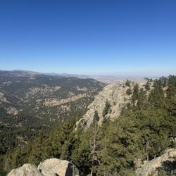
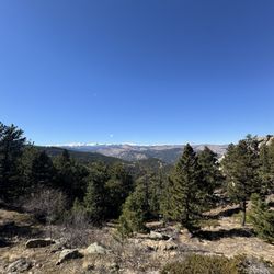
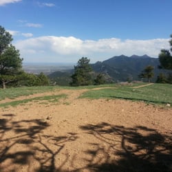
This view never gets old any time of year. But a warm day in Feb is rare in most years but not this year. We took a ride up to this point just as another was leaving from sunrise viewing. I just don't need to be up that early these days. There is a display with information describing the parts of the view and since this is my little city, I know what is where. In some light and times of year you can easily see my street if you know where to look. The campus and downtown are easy to identify. Enjoy a ride up but know the gates to all viewing spaces on Flagstaff are now locked at night to prevent issues that might start a wild land fire that could sweep down into town. read more


7 years ago
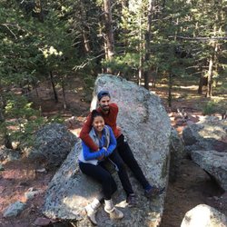
Hubby and I took a drive from Denver to Boulder and came across this scenic view. Absolutely gorgeous! I don't know the exact cities or parks we were able to see, since we're out of towners, but it was gorgeous. There was not a lot of parking spaces so you have to just take your shots and go. read more


More info about Panorama Point
Flagstaff Mountain Rd
Boulder, CO 80302
Directions
Hours
Outdoor Amenities


Panorama Point - hiking - Updated June 2026
Best of Boulder
People found Panorama Point by searching for…
Trending Searches in Boulder, CO
Amusement Parks near Panorama Point
Black Owned Nail Salons near Panorama Point
Boat Rental near Panorama Point
Cliff Jumping near Panorama Point
Dog Friendly Trails near Panorama Point
Fishing Spots near Panorama Point
Free Kids Activities near Panorama Point
Jet Ski Rental near Panorama Point
Outdoor Activities near Panorama Point
Pick Your Own Farms near Panorama Point
Public Shower near Panorama Point
Rock Quarry near Panorama Point
Running Trails near Panorama Point
Scenic Drive near Panorama Point
Secluded Spots near Panorama Point
Soccer Store near Panorama Point
Splash Pad near Panorama Point
Strawberry Picking near Panorama Point
Sunrise View near Panorama Point
Swimming Holes near Panorama Point
Swimming Lakes near Panorama Point
Swimming Pools near Panorama Point
Watch Sunset near Panorama Point
Browse Articles
Browse Nearby
BEST of Boulder, Colorado Restaurants near Panorama Point
BEST of Boulder, Colorado Coffee near Panorama Point
BEST of Boulder, Colorado Things to Do near Panorama Point
BEST of Boulder, Colorado Walking Trails near Panorama Point
BEST of Boulder, Colorado Parks near Panorama Point
BEST of Boulder, Colorado Breakfast near Panorama Point
BEST of Boulder, Colorado Hot Springs near Panorama Point
Browse Brands
Related Searches in Boulder, CO
Affordable Kayak Rental Services in Boulder, Colorado
Best Fishing Locations and Guides in Boulder, Colorado
Best Nature Trails for Hiking in Boulder, Colorado
Best Places for Horseback Riding in Boulder, Colorado
Check Out Off Road Trails in Boulder, Colorado
Discover Dog Friendly Trails to Explore in Boulder, Colorado
Discover Kid Friendly Hiking Trails in Boulder, Colorado
Discover Scenic Bike Paths in Boulder, Colorado
Discover Scenic Mountain Bike Trails Near Boulder, Colorado
Discover Scenic Waterfall Spots in Boulder, Colorado
Discover the Best Night Hike Trails in Boulder, Colorado
Dog-Friendly Hikes With Dogs in Boulder, Colorado
Enjoy Camping Adventures Around Boulder, Colorado
Enjoy Exciting Mountain Biking Adventures in Boulder, Colorado
Enjoy Kayaking Adventures in Boulder, Colorado
Enjoy River Tubing Adventures in Boulder, Colorado
Enjoy Tent Camping Spots Around Boulder, Colorado
Enjoy Water Activities and Fun in Boulder, Colorado
Enjoy a Beautiful Waterfall Hike in Boulder, Colorado
Enjoy the Best Picnic Spots and Ideas in Boulder, Colorado
Enjoy the Best Walking Path in Boulder, Colorado
Enjoy the Best Walking Trails in Boulder, Colorado
Exciting Cliff Jumping Spots in Boulder, Colorado
Experience Thrilling White Water Rafting in Boulder, Colorado
Explore Beautiful Parks and Green Spaces in Boulder, Colorado
Explore Easy Hikes Perfect for All in Boulder, Colorado
Explore Fun Activities to Do in Boulder, Colorado
Explore Popular Campgrounds Near Boulder, Colorado
Explore the Best Beach Spots in Boulder, Colorado
Explore the Best Boating Spots in Boulder, Colorado
Explore the Best Swimming Holes Around Boulder, Colorado
Explore the Best Trail Options in Boulder, Colorado
Family Friendly Hiking With Kids in Boulder, Colorado
Find Beautiful Views in Boulder, Colorado
Find Popular Ziplining Spots Around Boulder, Colorado
Find the Best Scenic View Locations in Boulder, Colorado
Great Places to Walk in Boulder, Colorado
Hiking Trails With Waterfalls in Boulder, Colorado
Off Leash Dog Hiking Trails in Boulder, Colorado
Plan a Scenic Drive Route Near Boulder, Colorado
Popular Outdoor Activities to Try in Boulder, Colorado
Popular Picnic Spots to Visit in Boulder, Colorado
Safe River Swimming Areas in Boulder, Colorado
Safe and Fun Parks for Kids in Boulder, Colorado
Top Climbing Spots and Gyms in Boulder, Colorado
Top Running Trails to Explore in Boulder, Colorado
Top Swimming Lakes to Enjoy in Boulder, Colorado
Top Swimming Spots and Pools in Boulder, Colorado