Royal Arch Photos


You might also consider
More like Royal Arch
Recommended Reviews - Royal Arch
Start your review...

Reviews With Photos


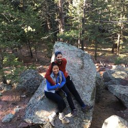
Start at the Chautauqua Trailhead (right by the parking lot by the ranger station). The parking lot is fairly small so you may have to park elsewhere. Walk toward the pine trees, to the left side. You will see signs eventually (as the trail system is interconnected here) but we did get a little confused so it helped to ask returning hikers. One of my favorite hikes. Really fun, pretty challenging but doable, and rewarding. About 3 miles round trip but primarily uphill on the way up. You're only on flat land for a short while at the start and then it's all uphill/climbing boulders. You'll feel it in your calves/booty the next day. Good hiking boots/sneakers are helpful here. Some of the rocks were wet too but I found them fairly easy to maneuver. Bring your hydration pack. The start of the hike is in the sun but you quickly disappear into the forest and the hardest parts of the hike are shaded. Still, it's quite a workout so you'll need the water. It's a popular hike and some of the spots are narrow so you do have to stop and let people pass. If possible, come on a weekday. There isn't much space to hang out once you reach the arch. It was a bit crowded with just a couple groups of hikers. Make sure you go through it to see the view. We found a spot to eat our lunch on a large rock. There was an adorable chipmunk that kept circling us, searching for snacks. Enjoy!

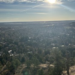
What an amazing hike! Came here the morning after GABF (took the bus from downtown Denver) and must say this was exactly what I needed to kick me back into shape. If you're not used to hiking at high elevation, prepare for an extra challenge. It's pretty much all uphill from the start of the trailhead at Chautauqua to the arch, but once you get there, huffing and puffing away, you'll realize it was so worth it. The panorama view is second to none, with the university to your left and downtown off in the distance to your right. What's directly ahead, you ask? Flatland/farmland as far as the eye can see! It was definitely a nice change being from Phoenix. I recommend bringing plenty of water and a light snack to stay hydrated and stave off that hunger, at least until you can get down haha! PS: if you're coming from out of town and staying in Denver, just take the bus from Union Station. That way you don't have to worry about parking! Hint: the parking scene at Chautauqua can get pretty crazy.

What a beautiful hike. Did this hike in Mid March and it was beautiful. It was 60s with some wind. The trail itself is about 3 miles round trip. It's a pretty decent workout. Not particular difficult, but can be a little challenging. Don't worry, the end is worth it. We came around 9ish and there were like no one at the arch. I heard it can get really packed and it can be difficult to take some good pictures. Luckily, it wasn't too busy. We came in march and most of the snow melted already. Highly recommended hike if you ever visit Boulder. Expect to spend 2-3 hours. Signs are pretty clear and not too difficult to follow. I suggest using AllTrails for current conditions and recommendations.

Visiting from WI, this trail was my first introduction to mountain hiking. I googled "best beginner hikes near Denver" and this trail was referenced on multiple sites with great reviews. (I wish I had done better research as the trail is actually rated as moderately difficult, but in this case, ignorance was bliss!) When I arrived at the park I stopped in the ranger station and explained I was an inexperienced hiker with a couple hours looking for an easy trail with great views, and the ranger pointed me to the Royal Arch trail, explaining "it's a little slippery in spots but just get muddy and you'll be fine." I feel like that ranger undersold the difficulty of the climb and how slippery it would be. I made it to the top though! And the views were totally worth the trouble and scary moments. I was in sneakers with no traction and had to climb on hands and knees at a couple points, and slid on my bottom quite a bit on the way down. Definitely wish I had spikes for the snowy parts. It took me almost 3.5 hours at a very slow pace, stopping every 30 yards or so on the top half to catch my breath and consider turning back, lol. Glad I didn't. I am not in great shape, but I was able to make it by taking my time and being very careful with my steps. My knees and feet were a bit sore at the end - if I had hiking boots they probably would've helped, but sneakers got me there and back. I would definitely recommend this trail for anyone looking to push themselves a bit and be rewarded with an amazing experience! it is difficult, but doable!


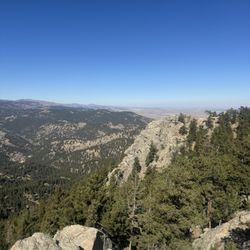
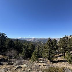
I found Royal Arch after searching Yelp hikes in Boulder. I wanted something that would be on the shorter distance side, so when I saw that this was about 3.5 miles, I figured it would be perfect. Well, it was about 3.5 miles, but the first half of the hike to the arch itself is a doozy: almost all uphill and will give your booty a great workout. Park at Chautauqua Park at 900 Baseline Road and from there you can choose from a plethora of hikes. We set off on a recent Saturday morning at 6:30am before it was too busy with other hikers. You cannot beat the views of the Flatirons and mountains around you even at the start. From then on, the hike to the arch just gets gradually more intense with the staircases made of stone and rock. The altitude does affect you if you're not used to it (like me) and I was huffing and puffing as we ascended. Along the way, we encountered lovely wildflowers and trickling streams. Watch for the signs to the Arch because we missed one, took a wrong turn and had to backtrack. However, when you do arrive at the Arch, it's definitely a sight to see. The rock formation is super cool and the views of the city are fabulous. We were lucky enough to have the arch to ourselves for a few minutes, too. Our timing was just right because as we made our descent back to our cars, there were lots of hikers on their way up. This is a strenuous but fun hike and the Arch is royally awesome.

I came to Colorado for a spring break trip & this is the first hike I did. It's a 3.4 mile hike, rated as difficult. Don't be nervous about the "difficult" rating. It was a workout but even as a novice, I thought it was really doable. Just make sure you have appropriate hiking shoes & enough water. There is a parking lot at the base of the hike in Chautauqua Park that is free, but first come first serve. It can fill up quickly as this is quite a popular & heavily trafficked hike. Even if it fills up, there are tons of free street parking on that same road just a quick walk away. We arrived at the ranger station & began our hike around 9:30 AM on a Sunday morning. As you first start, follow the grassy meadows uphill (where most of the crowd will be going). Eventually, people may start breaking off to different trails. Follow the signs for the Bluebell-Baird trail all the way until you reach a little shelter. Once you reach this, there will be a map and signs pointing to the Royal Arch. The route is pretty easy to follow and there weren't any forks in the road where I wasn't certain which way to go. The signs are very clear. For about 1/4 of the hike, you will be walking up and down dirt roads but after this, you will see rock stairs and this constitutes the majority of the rest of the hike. It's tiring, but a good workout and you can see wonderful views of Colorado along the way. I came in March. Typically, yack tracks are recommended because near the last 1/4 of the hike, trails can still be icy or filled with snow during winter or early spring. The day that I came was a pretty warm day in the 50s and I didn't encounter any of this, so I was able to finish without any. It just depends on the day and temperature, so do research accordingly. The arch itself is gorgeous.... Pictures most definitely don't do it justice. It's large & beautiful. You can climb on the rocks to the other side and sit and enjoy the gorgeous view or even eat some snacks/lunch. I would recommend doing this hike early to avoid the crowd. When we arrived at the arch, there were limited people there which allowed for good pictures and a nice, quiet view of the city. On our way down, we saw large crowds of people working their way up so I can easily see how quickly it gets crowded close to the afternoon. Overall, the hike itself took us about 3.5 hours to complete, but this was with about 40 or so minutes of stopping & taking pictures and sitting at the top to relax.

Always a go-to Boulder hike because it's very accessible, good elevation gain, fantastic view at the top. Expect crowds and some mild bouldering. If you're taking visitors to explore/shop/eat in Boulder this is a solid, well marked hike so you can get your exercise beforehand. Hike takes about 2.5 hours round trip. Sun and wind exposure for the first half; the second half is partial shade from trees. There are restrooms at the base and at the halfway point. There is also a large parking lot but sometimes it is full and you make need to park in surrounding neighborhoods.

What a view! From the top of the arch, you can see the entire city of Boulder all the way into Denver. Gorgeous! Things to note: - The trail itself is only 3.4 miles round trip, yet, the climb to the top is quite rigorous/steep making this a good hike for beginners and advanced hikers alike. - It's dog friendly, and the trail gives easy access for your pooche to hike along with you! - With lots of pine and spruce trees, it's almost completely shaded, which is nice for us pale faces! - It's one if the more popular hikes in Boulder, so it can get a bit crowded. We went on a Tuesday afternoon, and there was still quite a few people we passed along the trail. - Parking can be tricky, and there is limited spaces in Chautauqua Park, but there is some off street parking as well. Be prepared to get your sweat on and enjoy some beautiful nature! It's a top notch hike in my book!

There's not much to review... but if I were to put it in a few words it would be that -- THIS ARCH IS SO BEAUTIFUL! I honestly stood there staring at it for a good 10 minutes because I was in such awe. Beyond this arch, you climb a few big rocks (Don't be scared of heights!), and there's a view of the beautiful city of Boulder! What was so awesome was that you could even see Denver from up there. AMAZING! And a must if you're here and big into hiking!

I'm going to echo other reviewers here and state that I have now done nature's stair master!! Royal Arch Trail definitely has some stairs... Okay a TON of stairs. But all that aside It was a GREAT hike. Here's why: + From the Royal Arch trail head itself it's 1.1 miles to the arch with an elevation gain of 1400 feet (?!). + The trail is very well marked, which helped going through some of the more rocky portions. + Most of the trail is through a wooded area, which was great since it was still pretty hot out when I went. + Awesome views from the arch of both Boulder and the Flatirons. + You can get some fall color peeping in if you go at the right time of the season. I went mid October and saw some great color! +/- Lots of stairs. With such a large amount of elevation gain, in such a short distance you can bet it's going to be steep. Some of the stairs are a lot larger than your average step. Take your time and take breaks! +/- Get. There. Early! I arrived to Chautauqua Park at 7:30 am (on a Saturday) and the little lot by the ranger station was already full. Though I only encountered maybe ten people on the trail heading to Royal Arch. When I came down from the trail it was about 11 am and there were literally hundreds of people heading up to hike. - It does get super crowded under the arch. There's not much space to hang out for long. - The trail is pretty narrow in some spots and it can get difficult to maneuver around larger groups and their four legged friends. I came, I saw, I hiked that $#it! And I'd do it again too. **Pro Tip: It's very difficult to get the whole arch in a picture! There's a decent vantage point if you go to the left as you approach it.

Got there 7:20am today, the parking lot at Chautauqua was 3/4full. There are many hiking trails there, start at Chautauqua trail, then Bluebell-Baird trail, follow the sign of Royal Arch trail. We spent most the time on uphill staircase, very rocky trails, make sure take many stops if you needed. Bring plenty of water, and Snacks, good hiking shoes too! Hiking stick was helpful for us. It's a very beautiful trail, lots of hikers today with the long weekend. You can overlook CU/ Boulder on the top. Rated hard trail but not too bed. It's definitely worth it!

2 years ago
One of my favorite trails in Boulder located in Chautauqua park. It's a little over 3 miles with some elevation, but I think it's relatively easy. My friend who was visiting from sea level who doesn't hike much was able to do it with no problems. It's a beautiful hike through tree line, nice vertical and stone steps and a unique arch at the top! There are big rocks to sit on and enjoy the stunning vistas and observe sweet chipmunks running about. read more


2 years ago
The hiking conditions at Royal Arch turned out to be a lot more intense than I had expected - a good thing :-) Tip: While the hiking in intense, the views you experience while you hike aren't anything to write home about - quite disappointing. This is the kind of hiking trail that I'm not unhappy about having done once, but I really can't see myself coming back to repeat the experience. read more


Absolutely a stunning trail for beginners! I am a noob when it comes to hiking and haven't done too many hikes! This was a perfect beginner trail for me and our 4 month old puppy! Spectacular views!! There are multiple trails but we chose the longer and difficult one - leading to the arch; it's great for beginners! It took us about 3.5 hours with a real long snack break at the arch. The trail overall I wouldn't say is the easiest, there are parts where you need to climb/jump - again, completely doable for a beginner! You will see a lot of chipmunks on the trail which definitely entertained Coconut, my puppy! This is a heavily trafficked and loved trail by the locals for sure. Very scenic and beautiful! Parking can be a bit tricky specially during the weekends - we got parking in the parking lot but our friends had to street park - again completely doable! This has nothing to do with the trail but I was really glad that people were wearing masks while crossing each other - definitely made me feel better! Enjoyed the entire experience of hiking at Royal arch as a newbie to hiking and Colorado! Will definitely recommend read more


Nice hike with great views at the top! Steep inclines and stair-like climb. Get ready for your thighs to burn! Be sure to take snacks and PLENTY of water. More than you think you need. It gets hot very quickly. There is plenty of parking, especially the earlier you go in the morning. read more

Start at the Chautauqua Trailhead (right by the parking lot by the ranger station). The parking lot is fairly small so you may have to park elsewhere. Walk toward the pine trees, to the left side. You will see signs eventually (as the trail system is interconnected here) but we did get a little confused so it helped to ask returning hikers. One of my favorite hikes. Really fun, pretty challenging but doable, and rewarding. About 3 miles round trip but primarily uphill on the way up. You're only on flat land for a short while at the start and then it's all uphill/climbing boulders. You'll feel it in your calves/booty the next day. Good hiking boots/sneakers are helpful here. Some of the rocks were wet too but I found them fairly easy to maneuver. Bring your hydration pack. The start of the hike is in the sun but you quickly disappear into the forest and the hardest parts of the hike are shaded. Still, it's quite a workout so you'll need the water. It's a popular hike and some of the spots are narrow so you do have to stop and let people pass. If possible, come on a weekday. There isn't much space to hang out once you reach the arch. It was a bit crowded with just a couple groups of hikers. Make sure you go through it to see the view. We found a spot to eat our lunch on a large rock. There was an adorable chipmunk that kept circling us, searching for snacks. Enjoy! read more


What an amazing hike! Came here the morning after GABF (took the bus from downtown Denver) and must say this was exactly what I needed to kick me back into shape. If you're not used to hiking at high elevation, prepare for an extra challenge. It's pretty much all uphill from the start of the trailhead at Chautauqua to the arch, but once you get there, huffing and puffing away, you'll realize it was so worth it. The panorama view is second to none, with the university to your left and downtown off in the distance to your right. What's directly ahead, you ask? Flatland/farmland as far as the eye can see! It was definitely a nice change being from Phoenix. I recommend bringing plenty of water and a light snack to stay hydrated and stave off that hunger, at least until you can get down haha! PS: if you're coming from out of town and staying in Denver, just take the bus from Union Station. That way you don't have to worry about parking! Hint: the parking scene at Chautauqua can get pretty crazy. read more


9 years ago
What a beautiful hike. Did this hike in Mid March and it was beautiful. It was 60s with some wind. The trail itself is about 3 miles round trip. It's a pretty decent workout. Not particular difficult, but can be a little challenging. Don't worry, the end is worth it. We came around 9ish and there were like no one at the arch. I heard it can get really packed and it can be difficult to take some good pictures. Luckily, it wasn't too busy. We came in march and most of the snow melted already. Highly recommended hike if you ever visit Boulder. Expect to spend 2-3 hours. Signs are pretty clear and not too difficult to follow. I suggest using AllTrails for current conditions and recommendations. read more


7 years ago
Visiting from WI, this trail was my first introduction to mountain hiking. I googled "best beginner hikes near Denver" and this trail was referenced on multiple sites with great reviews. (I wish I had done better research as the trail is actually rated as moderately difficult, but in this case, ignorance was bliss!) When I arrived at the park I stopped in the ranger station and explained I was an inexperienced hiker with a couple hours looking for an easy trail with great views, and the ranger pointed me to the Royal Arch trail, explaining "it's a little slippery in spots but just get muddy and you'll be fine." I feel like that ranger undersold the difficulty of the climb and how slippery it would be. I made it to the top though! And the views were totally worth the trouble and scary moments. I was in sneakers with no traction and had to climb on hands and knees at a couple points, and slid on my bottom quite a bit on the way down. Definitely wish I had spikes for the snowy parts. It took me almost 3.5 hours at a very slow pace, stopping every 30 yards or so on the top half to catch my breath and consider turning back, lol. Glad I didn't. I am not in great shape, but I was able to make it by taking my time and being very careful with my steps. My knees and feet were a bit sore at the end - if I had hiking boots they probably would've helped, but sneakers got me there and back. I would definitely recommend this trail for anyone looking to push themselves a bit and be rewarded with an amazing experience! it is difficult, but doable! read more

. - Hiking Near Me")


Very challenging hike, however I did see a 5 year old make it to the top so it's doable. The trail isn't marked very well tho so I questioned whether I was going the right way at times. Overall, beautiful views and would climb again. read more

I found Royal Arch after searching Yelp hikes in Boulder. I wanted something that would be on the shorter distance side, so when I saw that this was about 3.5 miles, I figured it would be perfect. Well, it was about 3.5 miles, but the first half of the hike to the arch itself is a doozy: almost all uphill and will give your booty a great workout. Park at Chautauqua Park at 900 Baseline Road and from there you can choose from a plethora of hikes. We set off on a recent Saturday morning at 6:30am before it was too busy with other hikers. You cannot beat the views of the Flatirons and mountains around you even at the start. From then on, the hike to the arch just gets gradually more intense with the staircases made of stone and rock. The altitude does affect you if you're not used to it (like me) and I was huffing and puffing as we ascended. Along the way, we encountered lovely wildflowers and trickling streams. Watch for the signs to the Arch because we missed one, took a wrong turn and had to backtrack. However, when you do arrive at the Arch, it's definitely a sight to see. The rock formation is super cool and the views of the city are fabulous. We were lucky enough to have the arch to ourselves for a few minutes, too. Our timing was just right because as we made our descent back to our cars, there were lots of hikers on their way up. This is a strenuous but fun hike and the Arch is royally awesome. read more


I came to Colorado for a spring break trip & this is the first hike I did. It's a 3.4 mile hike, rated as difficult. Don't be nervous about the "difficult" rating. It was a workout but even as a novice, I thought it was really doable. Just make sure you have appropriate hiking shoes & enough water. There is a parking lot at the base of the hike in Chautauqua Park that is free, but first come first serve. It can fill up quickly as this is quite a popular & heavily trafficked hike. Even if it fills up, there are tons of free street parking on that same road just a quick walk away. We arrived at the ranger station & began our hike around 9:30 AM on a Sunday morning. As you first start, follow the grassy meadows uphill (where most of the crowd will be going). Eventually, people may start breaking off to different trails. Follow the signs for the Bluebell-Baird trail all the way until you reach a little shelter. Once you reach this, there will be a map and signs pointing to the Royal Arch. The route is pretty easy to follow and there weren't any forks in the road where I wasn't certain which way to go. The signs are very clear. For about 1/4 of the hike, you will be walking up and down dirt roads but after this, you will see rock stairs and this constitutes the majority of the rest of the hike. It's tiring, but a good workout and you can see wonderful views of Colorado along the way. I came in March. Typically, yack tracks are recommended because near the last 1/4 of the hike, trails can still be icy or filled with snow during winter or early spring. The day that I came was a pretty warm day in the 50s and I didn't encounter any of this, so I was able to finish without any. It just depends on the day and temperature, so do research accordingly. The arch itself is gorgeous.... Pictures most definitely don't do it justice. It's large & beautiful. You can climb on the rocks to the other side and sit and enjoy the gorgeous view or even eat some snacks/lunch. I would recommend doing this hike early to avoid the crowd. When we arrived at the arch, there were limited people there which allowed for good pictures and a nice, quiet view of the city. On our way down, we saw large crowds of people working their way up so I can easily see how quickly it gets crowded close to the afternoon. Overall, the hike itself took us about 3.5 hours to complete, but this was with about 40 or so minutes of stopping & taking pictures and sitting at the top to relax. read more


9 years ago
Always a go-to Boulder hike because it's very accessible, good elevation gain, fantastic view at the top. Expect crowds and some mild bouldering. If you're taking visitors to explore/shop/eat in Boulder this is a solid, well marked hike so you can get your exercise beforehand. Hike takes about 2.5 hours round trip. Sun and wind exposure for the first half; the second half is partial shade from trees. There are restrooms at the base and at the halfway point. There is also a large parking lot but sometimes it is full and you make need to park in surrounding neighborhoods. read more


9 years ago
What a view! From the top of the arch, you can see the entire city of Boulder all the way into Denver. Gorgeous! Things to note: - The trail itself is only 3.4 miles round trip, yet, the climb to the top is quite rigorous/steep making this a good hike for beginners and advanced hikers alike. - It's dog friendly, and the trail gives easy access for your pooche to hike along with you! - With lots of pine and spruce trees, it's almost completely shaded, which is nice for us pale faces! - It's one if the more popular hikes in Boulder, so it can get a bit crowded. We went on a Tuesday afternoon, and there was still quite a few people we passed along the trail. - Parking can be tricky, and there is limited spaces in Chautauqua Park, but there is some off street parking as well. Be prepared to get your sweat on and enjoy some beautiful nature! It's a top notch hike in my book! read more


There's not much to review... but if I were to put it in a few words it would be that -- THIS ARCH IS SO BEAUTIFUL! I honestly stood there staring at it for a good 10 minutes because I was in such awe. Beyond this arch, you climb a few big rocks (Don't be scared of heights!), and there's a view of the beautiful city of Boulder! What was so awesome was that you could even see Denver from up there. AMAZING! And a must if you're here and big into hiking! read more

I'm going to echo other reviewers here and state that I have now done nature's stair master!! Royal Arch Trail definitely has some stairs... Okay a TON of stairs. But all that aside It was a GREAT hike. Here's why: + From the Royal Arch trail head itself it's 1.1 miles to the arch with an elevation gain of 1400 feet (?!). + The trail is very well marked, which helped going through some of the more rocky portions. + Most of the trail is through a wooded area, which was great since it was still pretty hot out when I went. + Awesome views from the arch of both Boulder and the Flatirons. + You can get some fall color peeping in if you go at the right time of the season. I went mid October and saw some great color! +/- Lots of stairs. With such a large amount of elevation gain, in such a short distance you can bet it's going to be steep. Some of the stairs are a lot larger than your average step. Take your time and take breaks! +/- Get. There. Early! I arrived to Chautauqua Park at 7:30 am (on a Saturday) and the little lot by the ranger station was already full. Though I only encountered maybe ten people on the trail heading to Royal Arch. When I came down from the trail it was about 11 am and there were literally hundreds of people heading up to hike. - It does get super crowded under the arch. There's not much space to hang out for long. - The trail is pretty narrow in some spots and it can get difficult to maneuver around larger groups and their four legged friends. I came, I saw, I hiked that $#it! And I'd do it again too. **Pro Tip: It's very difficult to get the whole arch in a picture! There's a decent vantage point if you go to the left as you approach it. read more


9 years ago
Got there 7:20am today, the parking lot at Chautauqua was 3/4full. There are many hiking trails there, start at Chautauqua trail, then Bluebell-Baird trail, follow the sign of Royal Arch trail. We spent most the time on uphill staircase, very rocky trails, make sure take many stops if you needed. Bring plenty of water, and Snacks, good hiking shoes too! Hiking stick was helpful for us. It's a very beautiful trail, lots of hikers today with the long weekend. You can overlook CU/ Boulder on the top. Rated hard trail but not too bed. It's definitely worth it! read more


7 years ago
Great hike! It's a staircase climb and great workout. I needed to stop for lots of catch my breath breaks. The worst was when I was almost to the top and dropped my water bottle and watched it bounce down way too many steps. lucky me, got to climb those steps twice I put a mountain sticker over my dented bottle and will always remember this hike. But anyway, so worth all the effort-great view! Can't wait to do it again! read more


10 years ago
The Royal Arch was one of the most challenging (but also rewarding!) hikes I've ever done. I told my husband to pick a hike that had a "wow" at the end, and this one definitely did. It is just up, up, up - lots of BIG steps and rock scrambles. This is nature's stairclimber. I could feel my booty working and was sore for days. Parking lot fills up quickly. The woman in the ranger station was very helpful, but if you aren't a fan of taxidermy, do not go in here. Lots of beautiful, majestic animals, all dead and stuffed. I was not at all prepared for that! When we finally got to the royal arch, we sat on the edge and enjoyed the view and the friendly chipmunks. Then we found some trees and put up our hammock before beginning the trek down...which happily is much quicker and easier. Loved this hike, but it's a toughy. read more


8 years ago
Pretty strenuous last mile- lots of uphill and rocky, probably made a little more difficult for me by the altitude I wasn't adjusted to. The beautiful view made it worth it. The pictures of the arch don't do it justice. It's probably doable for most- we saw kids as young as 4 coming down, and plenty of pups but most of them were struggling a bit. My 10 year old definitely would not have made it. It was a beautiful hike and worth that last brutal part- and coming back was a breeze. I definitely recommend it if you are in the area! Make sure to bring plenty of water and good hiking shoes. read more


10 years ago
This is on April 2nd, 2016. It's a nice burly hike! Be careful: there is a lot of snowy slush on the trail and it makes going up difficult, and going down is a constant slide. It's pretty dangerous right now, so plan accordingly! The views are definitely worth the tricky hike, though. read more


9 years ago
Royal Arch is a great hike for beginner to seasoned hikers. The complete hike took us about 1.5 hours. Plenty of parking and a restroom at the bottom of the trail. You can see both downtown Denver and the U of Colorado from the Royal Arch. For a hike close to Denver, this one is a great choice! read more


11 years ago
10 years ago
Awesome hike! Great views of Boulder from the arch. The stone steps were killer but it's a good feeling to finally reach the arch. You definitely get a work out doing this hike. Make sure you bring lots of water. The arch itself was beautiful read more


9 years ago
7 years ago
8 years ago
10 years ago
More info about Royal Arch
Boulder, CO 80302
Directions
Visit Website
https://bouldercolorado.gov/trail/royal-arch
Hours
Outdoor Amenities
Ask the Community - Royal Arch
Review Highlights - Royal Arch


Royal Arch - hiking - Updated June 2026
Best of Boulder
People found Royal Arch by searching for…
Trending Searches in Boulder, CO
Amusement Parks near Royal Arch
Bird Sanctuary near Royal Arch
Black Owned Nail Salons near Royal Arch
Dog Friendly Things To Do near Royal Arch
Free Kids Activities near Royal Arch
Jet Ski Rental near Royal Arch
Outdoor Activities near Royal Arch
Running Trails near Royal Arch
Secluded Spots near Royal Arch
Strawberry Picking near Royal Arch
Swimming Holes near Royal Arch
Swimming Lakes near Royal Arch
Browse Articles
Browse Nearby
Browse Brands
Related Searches in Boulder, CO
Affordable Kayak Rental Services in Boulder, Colorado
Best Fishing Locations and Guides in Boulder, Colorado
Best Nature Trails for Hiking in Boulder, Colorado
Best Places for Horseback Riding in Boulder, Colorado
Check Out Off Road Trails in Boulder, Colorado
Discover Dog Friendly Trails to Explore in Boulder, Colorado
Discover Kid Friendly Hiking Trails in Boulder, Colorado
Discover Scenic Bike Paths in Boulder, Colorado
Discover Scenic Mountain Bike Trails Near Boulder, Colorado
Discover Scenic Waterfall Spots in Boulder, Colorado
Discover the Best Night Hike Trails in Boulder, Colorado
Dog-Friendly Hikes With Dogs in Boulder, Colorado
Enjoy Camping Adventures Around Boulder, Colorado
Enjoy Exciting Mountain Biking Adventures in Boulder, Colorado
Enjoy Kayaking Adventures in Boulder, Colorado
Enjoy River Tubing Adventures in Boulder, Colorado
Enjoy Tent Camping Spots Around Boulder, Colorado
Enjoy Water Activities and Fun in Boulder, Colorado
Enjoy a Beautiful Waterfall Hike in Boulder, Colorado
Enjoy the Best Picnic Spots and Ideas in Boulder, Colorado
Enjoy the Best Walking Path in Boulder, Colorado
Enjoy the Best Walking Trails in Boulder, Colorado
Exciting Cliff Jumping Spots in Boulder, Colorado
Experience Thrilling White Water Rafting in Boulder, Colorado
Explore Beautiful Parks and Green Spaces in Boulder, Colorado
Explore Easy Hikes Perfect for All in Boulder, Colorado
Explore Fun Activities to Do in Boulder, Colorado
Explore Popular Campgrounds Near Boulder, Colorado
Explore the Best Beach Spots in Boulder, Colorado
Explore the Best Boating Spots in Boulder, Colorado
Explore the Best Swimming Holes Around Boulder, Colorado
Explore the Best Trail Options in Boulder, Colorado
Family Friendly Hiking With Kids in Boulder, Colorado
Find Beautiful Views in Boulder, Colorado
Find Popular Ziplining Spots Around Boulder, Colorado
Find the Best Scenic View Locations in Boulder, Colorado
Great Places to Walk in Boulder, Colorado
Hiking Trails With Waterfalls in Boulder, Colorado
Off Leash Dog Hiking Trails in Boulder, Colorado
Plan a Scenic Drive Route Near Boulder, Colorado
Popular Outdoor Activities to Try in Boulder, Colorado
Popular Picnic Spots to Visit in Boulder, Colorado
Safe River Swimming Areas in Boulder, Colorado
Safe and Fun Parks for Kids in Boulder, Colorado
Top Climbing Spots and Gyms in Boulder, Colorado
Top Running Trails to Explore in Boulder, Colorado
Top Swimming Lakes to Enjoy in Boulder, Colorado
Top Swimming Spots and Pools in Boulder, Colorado