Gregory Canyon Photos


You might also consider
More like Gregory Canyon
Recommended Reviews - Gregory Canyon
Start your review...

Reviews With Photos

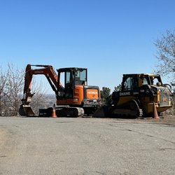
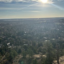
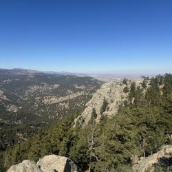
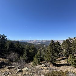
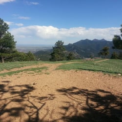
Marvelous trailhead with access to miles and miles of steep trails. You can probably access all of Boulder Mountain Park from this trailhead, and it's only about a mile from CU. Take Baseline west until the hairpin right turn where the road turns into Flagstaff; turn left instead to enter the short (~.25 mile) fee-enforced paved parking area. The trailhead area has bathrooms and a gate that closes at sundown. There's also free parking (in gravel pullouts) and access to other trails less than a quarter mile from the fee area. It's a pretty well-maintained (but not overly manicured) trailhead. The trails themselves are much more serious and technical. Nothing too extreme that you'd need a rope (unless you want to go off-trail and make it that way), and you don't have to traverse any precipitous cliffs, but it would be pretty impossible to bike these singletrack trails unless you're a magic goat. I could only run about three quarters going up; most of the trail is like a rock staircase. Trails are definitely well-maintained (wooden steps here and there in good condition). The knife-edge peaks are probably a lot of fun for a serious boulderer. I took Saddle Rock trail all the way to Green Mountain Peek (~2300 ft climb). About 1.3 miles up (~1200ft climb), Saddle Rock meets Amphitheater. If you're up for a quick (~30ft) rock climb, you go up a large pile of boulders to get a panoramic view over the countryside east of the Flatirons. Continue up to Green Mountain summit to conquer the jagged Flatiron ridgeline and get the full 360 degree panorama. You can peer down into Kossler lake and even see some snowy peaks along the western horizon. Turn around and you can see Denver, and (perhaps with enough beer) even Kansas.

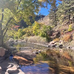
This trailhead is a hub with access to many other trails. I wanted to climb Flagstaff Mountain and there are multiple options to get to the top. I started with the GC trail and created a loop with Rangeview and Flagstaff. Rangeview delivered an amazing view of the Rockies. GC is on an incline so you get to look down into the creek and canyon. The western side also offers views of the adjacent Chautauqua Park. Flagstaff summit was not as dramatic, and upon the descent you look out onto Downtown Boulder. I inadvertently took Crown Rock trail, which I do not recommend. It has a lot of loose rocks and gets slippery. Trails were easy to follow and major intersections had clear signage. Only six parking spots! However, you can park for free with some off-road spots on Baseline Rd. I regret starting at 9:30 as trails were pretty sunny. Rangeview offered some needed shade. read more


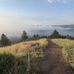
Wow what a marvelous trailhead! The other reviewer was right, you could get to all of Boulder Mountain Parks from here. I arrived around 11am on a weekday and the lot was about half full. There's a few trails that all connect up to Green Mountain, so take your pick. It too me about an hour to summit. The trail was beautiful and in better shape than the Bear Peak trail. It's less steep, but still pretty long and can be an adventure. You get some amazing views, better than Bear I think. Seeing the first flatiron above the fog was so pretty. The summit sports a register and a lot of chickadees begging for food. Don't feed them! Enjoy the mountain air and sunshine, and the fact your so close to town after your hike! read more


Made a day trip up to Boulder to see CU and Flatirons. We wanted to hike Saddle Ridge and discovered that you needed a Boulder County plate or purchase a day permit for $5. They have a convenient deposit box for you to fill out your info and enclose $5 in the envelope. From where CU's campus is to where we parked, it dropped about 10 degrees and while it was around 68 degrees, there was snow where the sun didn't shine. The hike itself was 1.3 miles and didn't prove to be too difficult, however there are several spots where you can go off that trail and explore and I have to say it was a little daring. With the snow and ice melting, it got pretty slick and muddy. I would definitely encourage caution when hiking. When we got to the top, it was a blazing 68 degrees again with the sun just baking you. The view is spectacular though. read more


15 years ago
Marvelous trailhead with access to miles and miles of steep trails. You can probably access all of Boulder Mountain Park from this trailhead, and it's only about a mile from CU. Take Baseline west until the hairpin right turn where the road turns into Flagstaff; turn left instead to enter the short (~.25 mile) fee-enforced paved parking area. The trailhead area has bathrooms and a gate that closes at sundown. There's also free parking (in gravel pullouts) and access to other trails less than a quarter mile from the fee area. It's a pretty well-maintained (but not overly manicured) trailhead. The trails themselves are much more serious and technical. Nothing too extreme that you'd need a rope (unless you want to go off-trail and make it that way), and you don't have to traverse any precipitous cliffs, but it would be pretty impossible to bike these singletrack trails unless you're a magic goat. I could only run about three quarters going up; most of the trail is like a rock staircase. Trails are definitely well-maintained (wooden steps here and there in good condition). The knife-edge peaks are probably a lot of fun for a serious boulderer. I took Saddle Rock trail all the way to Green Mountain Peek (~2300 ft climb). About 1.3 miles up (~1200ft climb), Saddle Rock meets Amphitheater. If you're up for a quick (~30ft) rock climb, you go up a large pile of boulders to get a panoramic view over the countryside east of the Flatirons. Continue up to Green Mountain summit to conquer the jagged Flatiron ridgeline and get the full 360 degree panorama. You can peer down into Kossler lake and even see some snowy peaks along the western horizon. Turn around and you can see Denver, and (perhaps with enough beer) even Kansas. read more


10 years ago
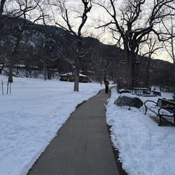
It's a trailhead and it costs $5 to park. I hiked the flatiron mountain with my girlfriend during the winter with some snow and ice. I would say most of the hiking is fairly easy, but it can be slippery at times, but we probably didn't have appropriate equipment. It gets a bit harder toward the top of the mountain, though. I've never really hiked much before, but some locals told us when we were nearly at the top, that it was probably not a good idea to continue without chains on our boots or picks to stay in place. We kind of regret listening and not just reaching the top of the 1st/2nd flatiron trail, but my girlfriend and I had fun nonetheless. read more

11 years ago
More info about Gregory Canyon
Gregory Canyon Rd
Boulder, CO 80305
Directions
Hours
Outdoor Amenities
Ask the Community - Gregory Canyon


Gregory Canyon - hiking - Updated June 2026
Best of Boulder
People found Gregory Canyon by searching for…
Hiking Trails With Waterfalls in Boulder, CO
Off Leash Dog Hikes in Boulder, CO
Beautiful Views in Boulder, CO
Stroller Friendly Hikes in Boulder, CO
Hiking With Kids in Boulder, CO
Free Things to Do in Boulder, CO
Off Road Trails in Boulder, CO
Parks With Shade in Boulder, CO
Trending Searches in Boulder, CO
Amusement Parks near Gregory Canyon
Bird Sanctuary near Gregory Canyon
Black Owned Nail Salons near Gregory Canyon
Boat Rental near Gregory Canyon
Cliff Jumping near Gregory Canyon
Dog Friendly Things To Do near Gregory Canyon
Fishing Spots near Gregory Canyon
Free Kids Activities near Gregory Canyon
Jet Ski Rental near Gregory Canyon
Outdoor Activities near Gregory Canyon
Public Pools near Gregory Canyon
Public Shower near Gregory Canyon
Rock Quarry near Gregory Canyon
Running Trails near Gregory Canyon
Scenic Drive near Gregory Canyon
Secluded Spots near Gregory Canyon
Soccer Store near Gregory Canyon
Splash Pad near Gregory Canyon
Strawberry Picking near Gregory Canyon
Sunrise View near Gregory Canyon
Swimming Holes near Gregory Canyon
Swimming Lakes near Gregory Canyon
Swimming Pools near Gregory Canyon
Watch Sunset near Gregory Canyon
Browse Articles
Browse Nearby
BEST of Boulder, Colorado Restaurants near Gregory Canyon
BEST of Boulder, Colorado Coffee near Gregory Canyon
BEST of Boulder, Colorado Things to Do near Gregory Canyon
BEST of Boulder, Colorado Walking Trails near Gregory Canyon
BEST of Boulder, Colorado Parks near Gregory Canyon
BEST of Boulder, Colorado Breakfast near Gregory Canyon
BEST of Boulder, Colorado Hot Springs near Gregory Canyon
Browse Brands
Related Searches in Boulder, CO
Affordable Kayak Rental Services in Boulder, Colorado
Best Fishing Locations and Guides in Boulder, Colorado
Best Nature Trails for Hiking in Boulder, Colorado
Best Places for Horseback Riding in Boulder, Colorado
Check Out Off Road Trails in Boulder, Colorado
Discover Dog Friendly Trails to Explore in Boulder, Colorado
Discover Kid Friendly Hiking Trails in Boulder, Colorado
Discover Scenic Bike Paths in Boulder, Colorado
Discover Scenic Mountain Bike Trails Near Boulder, Colorado
Discover Scenic Waterfall Spots in Boulder, Colorado
Discover the Best Night Hike Trails in Boulder, Colorado
Dog-Friendly Hikes With Dogs in Boulder, Colorado
Enjoy Camping Adventures Around Boulder, Colorado
Enjoy Exciting Mountain Biking Adventures in Boulder, Colorado
Enjoy Kayaking Adventures in Boulder, Colorado
Enjoy River Tubing Adventures in Boulder, Colorado
Enjoy Tent Camping Spots Around Boulder, Colorado
Enjoy Water Activities and Fun in Boulder, Colorado
Enjoy a Beautiful Waterfall Hike in Boulder, Colorado
Enjoy the Best Picnic Spots and Ideas in Boulder, Colorado
Enjoy the Best Walking Path in Boulder, Colorado
Enjoy the Best Walking Trails in Boulder, Colorado
Exciting Cliff Jumping Spots in Boulder, Colorado
Experience Thrilling White Water Rafting in Boulder, Colorado
Explore Beautiful Parks and Green Spaces in Boulder, Colorado
Explore Easy Hikes Perfect for All in Boulder, Colorado
Explore Fun Activities to Do in Boulder, Colorado
Explore Popular Campgrounds Near Boulder, Colorado
Explore the Best Beach Spots in Boulder, Colorado
Explore the Best Boating Spots in Boulder, Colorado
Explore the Best Swimming Holes Around Boulder, Colorado
Explore the Best Trail Options in Boulder, Colorado
Family Friendly Hiking With Kids in Boulder, Colorado
Find Beautiful Views in Boulder, Colorado
Find Popular Ziplining Spots Around Boulder, Colorado
Find the Best Scenic View Locations in Boulder, Colorado
Great Places to Walk in Boulder, Colorado
Hiking Trails With Waterfalls in Boulder, Colorado
Off Leash Dog Hiking Trails in Boulder, Colorado
Plan a Scenic Drive Route Near Boulder, Colorado
Popular Outdoor Activities to Try in Boulder, Colorado
Popular Picnic Spots to Visit in Boulder, Colorado
Safe River Swimming Areas in Boulder, Colorado
Safe and Fun Parks for Kids in Boulder, Colorado
Top Climbing Spots and Gyms in Boulder, Colorado
Top Running Trails to Explore in Boulder, Colorado
Top Swimming Lakes to Enjoy in Boulder, Colorado
Top Swimming Spots and Pools in Boulder, Colorado