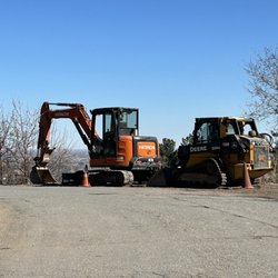
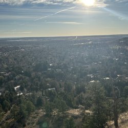
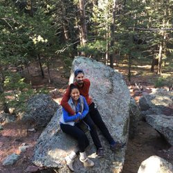
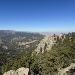
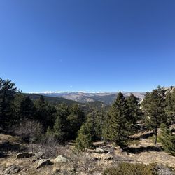
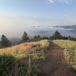
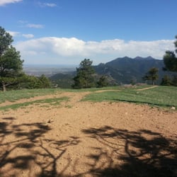
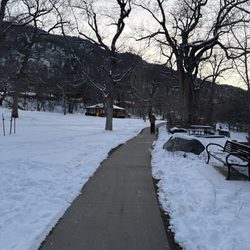
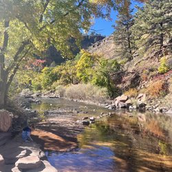
Mt. Sanitas Trail Photos


You might also consider
More like Mt. Sanitas Trail
Recommended Reviews - Mt. Sanitas Trail
Start your review...

Reviews With Photos

Stairmaster in nature, walking up the rock formations for the first half. Pleasant views of Downtown and neighboring mountains. Moderate difficulty while giving your quads a good workout. No blazes but the trail is fairly easy to follow. There isn't a prominent sign for the trailhead and there are a few along the road. Choose between street parking or a lot for another trail up the road. Downhill was primarily a dirt road ( or versa since this is a loop). It can be a little slippery if there is recent snow or rain.

Such a pretty hike! Mount Sanitas has a great mix of inclines and flat paths that reveal some of the most gorgeous views of Boulder and beyond. What's nice is that you can truly control how easy or how difficult that you want your hike to be. I did a 4 mile loop trail from the Sanitas Valley trail to the Mount Sanitas trail, and it gave me a great mix of everything that I was looking for. The Sanitas Valley Trail starts off easy with a flat, wide sandy path. It then begins to gradually incline until you reach a few trail splits. At the top of this trail, there's a beautiful vista point that has a nice view of the city. From here, you can connect to a few different trails. This is where I connected to the Mount Sanitas trail. Unlike the Sanitas Valley trail, the Mount Sanitas trail is super rocky and features several inclining switchbacks. This trail is super steep and slippery with lots of uneven rocky terrain. This is definitely the most difficult part of the trail and will require some scrabbling up large rocks. This section is short but you'll have to be careful and take your time. It's totally doable but would definitely wear shoes with good traction to prevent lots of slipping. Once you make it up to the top, you'll see a barrier and that's the Mount Sanitas summit. This is where you'll see the best views. Coming down the Mount Sanitas trail was actually more difficult than going up for me. It's even more steep and slippery on the downhill than it is on the uphill. For those with bad knees; I'd avoid going down this way or at least bring your hiking poles to relieve the pressure from your knees. My knees weren't affected as much, but my thighs and feet were definitely burning. You will feel it all in your quads since you basically have to stop yourself from slipping down that steep hill. Definitely a killer workout coming down. I came here during the week in the late afternoon, and there weren't too many people out. But the people that I did come in contact with were very friendly. There's a small parking lot across the street with limited parking spaces. During the week, it was pretty easy to find a space, but I'm sure it fills up on the weekends. There's also a really cute little picnic area that's nestled between some trees near the entrance. I took a snack break here and it was really chill. This was easily one of my favorite Colorado hikes. I would love to come back again to explore more of the trails within this park. I'd highly recommend the Sanitas Valley-Mount Sanitas trail loop if you don't mind a little scrabbling. Also, make sure you bring water and wear sunscreen as this entire trail loop is pretty much exposed. It's an excellent workout with some super scenic and rewarding views once you reach the summit.

I've been having dreams about this hiking experience since we came back from Colorado. It's been two weeks and I'm losing sleep! Hubby'a niece and her boyfriend plus their two dogs took me here. They are expert climbers. I'm an expert on taking a break between the hike and shoot tons of photographs! This was the most challenging trail I've ever done in my life! Finally, I made it to the top, at 6,843 ft! With my new sweatshirt, pants, and cap, I had an excellent fashion show on top of Mount Sanitas. They imposed the covid rule, so every climber/hiker must wear a mask. I passed a breathtaking scenery along the way--what a beautiful place to be. We started from the most challenging trail climbing up to the top and going the other way to reach the ground but hitting the ground from the top wasn't easy either. When we made it to the top and looked down on Boulder, I saw a beautiful city from above. It was almost like looking at my miniature village, pretty awesome, except the miniature one was a mass of paper. I think best to hike yourself and witness the beautiful city yourself because of the feeling of being up there is not the same as looking at the pictures. While walking back to the car, we saw a lost baby fox staring at the passers-by. It's cute but I doubt I can adopt. All in all, the hike took about an hour and a half to two hours because I had to take a min break here and there due to my photography skills, haha. The views were magnificent! I'll do it again if I get a chance. Awesome!


This is the best FREE workout in Boulder! The first quarter mile or so is a punch in the gut and mouth out the same time and will make you want to quit. The trail is abundant with wildlife and AMAZING views! The view at the top is incredible with views of Pikes peak to the south, and Boulder to the east. It's about a 3 mile loop with about 1,200 ft elevation gain in just over a mile. Definitely a must do if you're in the Boulder area and looking for a nature outing.

The climb up the trail is beautiful right now! Everything is green and the wildflowers are blooming. It took about an hour to the top with a few photo stops. It seems a bit more than moderate and it will definitely get your heart pumping. There aren't really any level parts, it's pretty much up and back down. I definitely recommend this trail!

Beautiful! This is a moderate to hard hike due to the steep elevation and non sturdy ground at times. We had no problem getting up and sometimes with vertical inclines we had to climb. Getting down sometimes required us to take on the sexy crab walk to decline off some rocks. Views of Boulder were beautiful. There was plenty parking on a weekend too so that was a nice surprise. Bring plenty of water! We mistook how long this would take us and were pretty parched at the end of our hike haha. All in all a great workout and well worth the view once you get to the top!

Beautiful hike on Mt trail and Lions Lair. Nice paths,some rocky parts and steep ascent and decsent. Kind of busy but dog owners not picking up after Fido or picking up the poo and leaving the full bag along the trail. It was a pretty area and we enjoyed every step. We went at 8 AM and there were a half dozen open parking spots. I will do this hike again I think we logged 6.9 miles with some of it a little difficult.

One of my favorite hikes! Free street parking is easy to come by on Mapleton Avenue. I recommend taking the trail to the left which is a mile stair climb to the top. There are several great resting points along the path with a great view of Boulder, CO from the top! From there I recommend taking the East Ridge trail down, which is on the other side of where you entered the top, to the Sanitas Valley trail a nice 2-mile descent. Altogether an enjoyable 3 mile climb that takes roughly 2 hours.

A 3.3 mile hike across Boulder's open space trails and galore! Just off of Sunshine Canyon Dr., and Mapleton Ave, this trail is very enjoyable and very challenging for beginners, but a low impact for those who are goat legged. The parking can be free at times, especially coming as the early bird. Great trail for a 2-3 hour hike traveling up and along the ridge line. I like to go in the evenings, and overlook the Boulder area and surrounding valley. Weekends are very busy with hikers and trail runners but trail is fairly wide for the most part. Take care on wet days as rocks may be rather slick. Dogs are welcome as long as they are on leash or well disciplined. Definitely start to the left, hard stuff first. Then make your way down slowly after the top. Gorgeous area! The way down (on the east) was a lot of fun scrambling and then winding through the valley. Saw folks of all sorts on the trail, from the elderly to people doing it with toddlers on their back. It was difficult but doable and left me with a sense of accomplishment.

Hiked this trail for the first time last Sunday and it was awesome! We went from the trailhead on all trails aka climbed the stairs up instead of down. It was an awesome work out with beautiful views. Noticed a lot of people running it as well. A great work out and would def come back. There were a few icy spots on the trail but nothing requiring different shoes, just some caution - esp for those carrying babies or 3 year olds in our case! My only con is that not everyone... or almost no one leashes their dogs. There are a few parking lots but best to get their early to swipe a spot. We started around 8am and had no trouble!

This is a beautiful but challenging hike. I loved the incline and views! It is possibly one of my new favorite hikes in Boulder, Colorado. A friend of mine kept telling me how awesome it was so I decided to give it a try. Right of the bat the hike is straight up and I got a little worried. But I like a challenge so I pushed my through and ended up beating my friends time by 7 minutes. I felt so much energy by the nice people passing and encouraging me. I have to mention the gorgeous views as well. You have a beautiful view of Boulder and the Flatirons. I have decided to try to hike Sanita's once a week and try to make it up and down in less than an hour. I don't know if I can but the challenge is fun. There are so many great hikes in Boulder but this one is truly one of the best!!

This place is definitely a must come sunshine or a little snow. The trail is maintained well and has a good mix of steps and rocky ascent. Careful on the way down as it can get a little slippery when wet. Towards the top it can get a little confusing as there are no clear signs that point you through several passages of boulders (part of trail) so be on the lookout if you want to stay the course. Afternoons can bring a lot of foot traffic so if you plan on jogging or running I suggest you go early morning. Same thing with parking. Overall, there are awesome views of the city of Boulder or the million dollar homes that pepper the foothills. The hike is moderate but if it's your first time at this altitude definitely bring water and a snack.

2 years ago


We hiked the Mount Sanitas east ridge trail. It was a little over 3 miles. There was a small patch of ice on one area which is why we're glad to went the direction we did. We had a boulder a bit to the top but the clear day made for amazing views. read more

Stairmaster in nature, walking up the rock formations for the first half. Pleasant views of Downtown and neighboring mountains. Moderate difficulty while giving your quads a good workout. No blazes but the trail is fairly easy to follow. There isn't a prominent sign for the trailhead and there are a few along the road. Choose between street parking or a lot for another trail up the road. Downhill was primarily a dirt road ( or versa since this is a loop). It can be a little slippery if there is recent snow or rain. read more


Such a pretty hike! Mount Sanitas has a great mix of inclines and flat paths that reveal some of the most gorgeous views of Boulder and beyond. What's nice is that you can truly control how easy or how difficult that you want your hike to be. I did a 4 mile loop trail from the Sanitas Valley trail to the Mount Sanitas trail, and it gave me a great mix of everything that I was looking for. The Sanitas Valley Trail starts off easy with a flat, wide sandy path. It then begins to gradually incline until you reach a few trail splits. At the top of this trail, there's a beautiful vista point that has a nice view of the city. From here, you can connect to a few different trails. This is where I connected to the Mount Sanitas trail. Unlike the Sanitas Valley trail, the Mount Sanitas trail is super rocky and features several inclining switchbacks. This trail is super steep and slippery with lots of uneven rocky terrain. This is definitely the most difficult part of the trail and will require some scrabbling up large rocks. This section is short but you'll have to be careful and take your time. It's totally doable but would definitely wear shoes with good traction to prevent lots of slipping. Once you make it up to the top, you'll see a barrier and that's the Mount Sanitas summit. This is where you'll see the best views. Coming down the Mount Sanitas trail was actually more difficult than going up for me. It's even more steep and slippery on the downhill than it is on the uphill. For those with bad knees; I'd avoid going down this way or at least bring your hiking poles to relieve the pressure from your knees. My knees weren't affected as much, but my thighs and feet were definitely burning. You will feel it all in your quads since you basically have to stop yourself from slipping down that steep hill. Definitely a killer workout coming down. I came here during the week in the late afternoon, and there weren't too many people out. But the people that I did come in contact with were very friendly. There's a small parking lot across the street with limited parking spaces. During the week, it was pretty easy to find a space, but I'm sure it fills up on the weekends. There's also a really cute little picnic area that's nestled between some trees near the entrance. I took a snack break here and it was really chill. This was easily one of my favorite Colorado hikes. I would love to come back again to explore more of the trails within this park. I'd highly recommend the Sanitas Valley-Mount Sanitas trail loop if you don't mind a little scrabbling. Also, make sure you bring water and wear sunscreen as this entire trail loop is pretty much exposed. It's an excellent workout with some super scenic and rewarding views once you reach the summit. read more


I've been having dreams about this hiking experience since we came back from Colorado. It's been two weeks and I'm losing sleep! Hubby'a niece and her boyfriend plus their two dogs took me here. They are expert climbers. I'm an expert on taking a break between the hike and shoot tons of photographs! This was the most challenging trail I've ever done in my life! Finally, I made it to the top, at 6,843 ft! With my new sweatshirt, pants, and cap, I had an excellent fashion show on top of Mount Sanitas. They imposed the covid rule, so every climber/hiker must wear a mask. I passed a breathtaking scenery along the way--what a beautiful place to be. We started from the most challenging trail climbing up to the top and going the other way to reach the ground but hitting the ground from the top wasn't easy either. When we made it to the top and looked down on Boulder, I saw a beautiful city from above. It was almost like looking at my miniature village, pretty awesome, except the miniature one was a mass of paper. I think best to hike yourself and witness the beautiful city yourself because of the feeling of being up there is not the same as looking at the pictures. While walking back to the car, we saw a lost baby fox staring at the passers-by. It's cute but I doubt I can adopt. All in all, the hike took about an hour and a half to two hours because I had to take a min break here and there due to my photography skills, haha. The views were magnificent! I'll do it again if I get a chance. Awesome! read more


5 years ago
This is the best FREE workout in Boulder! The first quarter mile or so is a punch in the gut and mouth out the same time and will make you want to quit. The trail is abundant with wildlife and AMAZING views! The view at the top is incredible with views of Pikes peak to the south, and Boulder to the east. It's about a 3 mile loop with about 1,200 ft elevation gain in just over a mile. Definitely a must do if you're in the Boulder area and looking for a nature outing. read more


The climb up the trail is beautiful right now! Everything is green and the wildflowers are blooming. It took about an hour to the top with a few photo stops. It seems a bit more than moderate and it will definitely get your heart pumping. There aren't really any level parts, it's pretty much up and back down. I definitely recommend this trail! read more


Beautiful! This is a moderate to hard hike due to the steep elevation and non sturdy ground at times. We had no problem getting up and sometimes with vertical inclines we had to climb. Getting down sometimes required us to take on the sexy crab walk to decline off some rocks. Views of Boulder were beautiful. There was plenty parking on a weekend too so that was a nice surprise. Bring plenty of water! We mistook how long this would take us and were pretty parched at the end of our hike haha. All in all a great workout and well worth the view once you get to the top! read more


Beautiful hike on Mt trail and Lions Lair. Nice paths,some rocky parts and steep ascent and decsent. Kind of busy but dog owners not picking up after Fido or picking up the poo and leaving the full bag along the trail. It was a pretty area and we enjoyed every step. We went at 8 AM and there were a half dozen open parking spots. I will do this hike again I think we logged 6.9 miles with some of it a little difficult. read more


5 years ago
One of my favorite hikes! Free street parking is easy to come by on Mapleton Avenue. I recommend taking the trail to the left which is a mile stair climb to the top. There are several great resting points along the path with a great view of Boulder, CO from the top! From there I recommend taking the East Ridge trail down, which is on the other side of where you entered the top, to the Sanitas Valley trail a nice 2-mile descent. Altogether an enjoyable 3 mile climb that takes roughly 2 hours. read more

A 3.3 mile hike across Boulder's open space trails and galore! Just off of Sunshine Canyon Dr., and Mapleton Ave, this trail is very enjoyable and very challenging for beginners, but a low impact for those who are goat legged. The parking can be free at times, especially coming as the early bird. Great trail for a 2-3 hour hike traveling up and along the ridge line. I like to go in the evenings, and overlook the Boulder area and surrounding valley. Weekends are very busy with hikers and trail runners but trail is fairly wide for the most part. Take care on wet days as rocks may be rather slick. Dogs are welcome as long as they are on leash or well disciplined. Definitely start to the left, hard stuff first. Then make your way down slowly after the top. Gorgeous area! The way down (on the east) was a lot of fun scrambling and then winding through the valley. Saw folks of all sorts on the trail, from the elderly to people doing it with toddlers on their back. It was difficult but doable and left me with a sense of accomplishment. read more


Hiked this trail for the first time last Sunday and it was awesome! We went from the trailhead on all trails aka climbed the stairs up instead of down. It was an awesome work out with beautiful views. Noticed a lot of people running it as well. A great work out and would def come back. There were a few icy spots on the trail but nothing requiring different shoes, just some caution - esp for those carrying babies or 3 year olds in our case! My only con is that not everyone... or almost no one leashes their dogs. There are a few parking lots but best to get their early to swipe a spot. We started around 8am and had no trouble! read more

This is a beautiful but challenging hike. I loved the incline and views! It is possibly one of my new favorite hikes in Boulder, Colorado. A friend of mine kept telling me how awesome it was so I decided to give it a try. Right of the bat the hike is straight up and I got a little worried. But I like a challenge so I pushed my through and ended up beating my friends time by 7 minutes. I felt so much energy by the nice people passing and encouraging me. I have to mention the gorgeous views as well. You have a beautiful view of Boulder and the Flatirons. I have decided to try to hike Sanita's once a week and try to make it up and down in less than an hour. I don't know if I can but the challenge is fun. There are so many great hikes in Boulder but this one is truly one of the best!! read more


This place is definitely a must come sunshine or a little snow. The trail is maintained well and has a good mix of steps and rocky ascent. Careful on the way down as it can get a little slippery when wet. Towards the top it can get a little confusing as there are no clear signs that point you through several passages of boulders (part of trail) so be on the lookout if you want to stay the course. Afternoons can bring a lot of foot traffic so if you plan on jogging or running I suggest you go early morning. Same thing with parking. Overall, there are awesome views of the city of Boulder or the million dollar homes that pepper the foothills. The hike is moderate but if it's your first time at this altitude definitely bring water and a snack. read more


Our hotel said this hike was a top 5 tourist attraction, and I can see why. I always appreciate a good hike, and my cousin (a local) insisted we hit the trail at 6am to appreciate the sun rise. It was COLD on this November morning, in the 20's. BUT, once you get moving your core temperature will keep you warm. This is not a long arduous trail, but a quality condensed experience of everything this hill-side city has to offer in terms of natural beauty as well as a great workout - intensity is dependent on your pace, allowing for a strenuous hillside blast for the most vigorous athletes, or a relaxing accent for couch dwellers. We kept a brisk pace and hit the top in about 40 minutes. Sanitas takes a little familiarity to know about, which makes it less crowded versus the flat iron trails. Still, you will most likely come across a few fellow hikers, even early in the morning we did, the trail offers a much more scenic experience than the southern alternative. If you really want some private exploring, check out sunshine canyon, but it is shaded, so much colder. We enjoyed our morning! You can make the hike in running shoes, no problem. read more


13 years ago
First time doing Mt. Sanitas aka Manzanitas (for some of us spanish speakers). I definitely underestimated it's hardcoreness but enjoyed it a lot. The PARKING LOT for this trail is a little ways down from where the hike actually starts. There are BATHROOMS available, which I highly recommend you use because the hike is not at all fast...unless you are one of those people who are timing themselves. Once you start the trail there are a few routes you can take...I think we took the standard route. The hike wasn't hard but we had to go slow because there were a lot of rocks and the pathway was steadily inclining. It actually took us about 2 hrs to complete. When we recorded the distance it was about 1.5 miles going up, coming down there's an alternate route which we didn't take in fear of getting lost. Overall the hike was scenic, nice, and a great workout. I would say it's a definite must if you are visiting Boulder! Remember: -CO has a higher elevation so you may run out of breath faster. -Bring shoes you don't really care for. -Bring water! -Go in the early morning or late afternoon. read more

15 years ago
Mt. Sanitas Trail is among my favorite walking/hiking spots in Boulder. If you want to avoid Chautauqua Park crowds, have plenty of parking and get in and out in under 2 hours with a terrific endorphin blast with fabulous views (even though not as challenging or dramatic as other hiking venues), check out Mt. Sanitas. It's very kid or beginner friendly, there are terrain choices for those not wanting to work that hard, too. Several trails, and all pretty damn easy and enjoyable.. This trip I've been here three times in the early a.m. before my meetings. First rate. read more


11 years ago
A great, short hike just outside town. Given it's proximity to town, it can get very crowded, so plan accordingly. Parking isn't usually an issue if you go to some of the nearby streets. There are several spots to stop and get big, panoramic views to the east and a glimpse of the mountains to the west. The actual hike is moderately difficult but not at all technical. Essentially zero exposure and a hike that you can be very comfortable taking kids on. As with a lot of hikes, the summit is often pretty crowded, but its still rewarding. This is a nice hike to take visitors on as it doesn't take up a huge chunk of time and the altitude isn't bad at all....nothing like taking a flat lander to a 14er. You can do an out and back or a loop; doing the loop is a little easier decent and ends up being pretty flat going through the canyon. As far as time, you can summit in around 30 minutes if you hoof it, but if you are at more leisurely pace and actually take in some of the views, plan on around 60+ minutes. Sunrise at the top is a pretty hard to beat. read more

10 years ago
This is a near-daily habit for me. As a trail runner, I try to beat :22 to the summit, and :37 round trip along the most direct ridge trail. Most people should allow about :45 to an hour to summit, and it is a solid achievement just to make it up without stopping. Whatever your fitness level, the views are totally worth it! Another great thing about this trail is practicing your footwork. This is a stair stepper, for sure, and so you need to have your wits about you as you navigate this rocky trail. There are several steep grades to navigate that might require a little caution, especially on weekends when the trail has a lot of traffic on it. Overall, I suggest that most people bring a bottle of water + some band-aids in case you scrape on a rock or two. Cell phones work along the entire trail. There are some great options to loop this trail; either going over the top and down the longer trail, or along the back to Lions Lair. You can tailor this loop to all levels of physical ambition. read more

Hands-down, this is my favorite Boulder area hike. Beautiful views and a good little workout. This hike is perfect in the spring because the snow melts more quickly from this sunny trail than nearby mountains. And if you're feeling tired, it's still a great hike as it affords beautiful views of Boulder just a short distance in. Three suggestions: - Don't hike between 11AM-4PM on a cool summer day - this trail gets packed! - Also, beware that this trail is fairly exposed and sunny. So, rain gear, sunblock, and lots of water are must-haves. - To mix things up, do the loop (3.2 mi) that goes down the east side of the mountain from the top and connects to the wide, graveled footpath. read more

15 years ago
Since we were hiking for exercise, we followed Drew A.'s advice and started our hike by veering to the right (East) at the initial fork (counterclockwise). I think it probably was the best way to go, and the only way I would hike this trail. As he mentioned, this gave us a nice warm-up in the beginning of the hike since it starts off with a 1 mile gradual uphill walk on flat surface. Next we hit a tough uphill climb with plenty of rocks to scramble over. I had to take a few breaks here, but once we reached the top there was a beautiful view of Boulder Valley and nearby mountain tops, and it was all downhill the rest of the way back. Since we hiked late in the afternoon, this route gave us optimum exposure to the sun. We had just enough sunlight to climb the East side and then as we headed down the West side, we were able to catch the beginning of the sunset. Plus, since we were going downhill, we had plenty of opportunities to enjoy the gorgeous mountaintop views on this side of the loop. A word of caution: Going down the Mt. Sanitas Trail can be slippery even when not wet. I slipped multiple times on loose sand on top of smooth rocks. A good pair of hiking shoes with better tread than my old sneakers would have been great ;) Coming down was also a little tough on the knees as there are lots of rocks and steps on the West side of the loop. Overall this is a great trail that I hope to come back to again soon! read more


It took about 2 hours and my tush and legs were screaming for 3 days straight. This is not an easy or leisure hike at all...it's a work out, but that's what I was hoping for! I still like the hike up to Royal Arch better but love the variety in Boulder. read more


5 years ago
10 years ago
Great hike! Harder than I expected! There are a lot of big rocks to hike up and down over. Lots of people walking cute dogs and awesome views of Boulder - start at centennial trailhead then cross the street at the crosswalk to get to trailhead. We started hiking the East Ridge trail and that met up with Mount Sanitas trail around the top. There are also other trails you can get to from this trail such as Dakota Ridge trail and Goat trail. Wear hiking boots because there are some slippery areas. Also, there are quite a few lookout points--so bring your camera! read more


15 years ago
6 years ago
11 years ago
I love hiking but this trail wasn't quite what I expected. After reading about it online, I assumed that it would be a short 2 mile easy to moderate hike with a great view. When we started the hike, the trail quickly turned into a vertical climb and stayed that way for the duration. I definitely admit that my expectations were off, but it was definitely challenging for both of us. Once getting to the top, the views of Boulder were spectacular. The trail down was just as steep but going downhill which was also more challenging than expected. I think what makes it difficult is the large elevation gain in such a short distance. Overall I'm glad that we hiked this trail but aren't sure if we will be back. read more

15 years ago
If you want to get in a quick run/hike with some elevation gain Mt Sanitas is a great choice. As others have mentioned a loop linking up W Ridge trail or Dakota Ridge is recommended. Note that the dirt gets a bit sticky when wet due to the high clay content and some trails are worse than others. The park is great year round, but consider traction devices (e.g. Yaktrax) in the winter if you're uncomfortable on hard packed snow/ice. There's also bouldering (mostly easy) fairly close to the trailhead (routes described here: http://www.mountainproject.com/v/mount-sanitas/105744361). read more


Page 1 of 2
More info about Mt. Sanitas Trail
4TH St And Mapleton Ave
Boulder, CO 80302
Directions
Hours
Indoor Amenities
Outdoor Amenities
Ask the Community - Mt. Sanitas Trail
Review Highlights - Mt. Sanitas Trail


Why does Yelp recommend reviews?
8 reviews that are not currently recommended
The reviews below are not factored into the business's overall star rating.
13 years ago
13 years ago
2 years ago
13 years ago
3 years ago
8 years ago
14 years ago
12 years ago
Mt. Sanitas Trail - hiking - Updated June 2026
Best of Boulder
People found Mt. Sanitas Trail by searching for…
Things to Do in Boulder, Colorado
Attractions in Boulder, Colorado
Public Shower in Boulder, Colorado
Scenic View in Boulder, Colorado
Hiking Trails With Waterfalls in Boulder, Colorado
Scenic Drive in Boulder, Colorado
Sunrise View in Boulder, Colorado
Scenic Overlook in Boulder, Colorado
Easy Hikes in Boulder, Colorado
Natural Hot Springs in Boulder, Colorado
Off Leash Dog Hikes in Boulder, Colorado
Lookout Points in Boulder, Colorado
Secret Spots in Boulder, Colorado
Photo Spots in Boulder, Colorado
Watch Sunset in Boulder, Colorado
Sunset View in Boulder, Colorado
Stair Climbing in Boulder, Colorado
Stairs Workout in Boulder, Colorado
Night Hike in Boulder, Colorado
Walking Trails in Boulder, Colorado
Trending Searches in Boulder, CO
Black Owned Nail Salons near Mt. Sanitas Trail
Boat Rental near Mt. Sanitas Trail
Cliff Jumping near Mt. Sanitas Trail
Day Trips near Mt. Sanitas Trail
Dog Friendly Things To Do near Mt. Sanitas Trail
Fishing Spots near Mt. Sanitas Trail
Jet Ski Rental near Mt. Sanitas Trail
Kayak Rental near Mt. Sanitas Trail
Lakes & Ponds near Mt. Sanitas Trail
Outdoor Activities near Mt. Sanitas Trail
Parks For Picnics near Mt. Sanitas Trail
Pick Your Own Farms near Mt. Sanitas Trail
Places To Walk Around near Mt. Sanitas Trail
Public Shower near Mt. Sanitas Trail
River Swimming near Mt. Sanitas Trail
Rock Quarry near Mt. Sanitas Trail
Scenic Night View near Mt. Sanitas Trail
Scenic Overlook near Mt. Sanitas Trail
Secluded Spots near Mt. Sanitas Trail
Soccer Store near Mt. Sanitas Trail
Splash Pad near Mt. Sanitas Trail
Strawberry Picking near Mt. Sanitas Trail
Sunrise View near Mt. Sanitas Trail
Swimming Holes near Mt. Sanitas Trail
Swimming Lakes near Mt. Sanitas Trail
Browse Articles
Browse Nearby
BEST of Boulder, Colorado Restaurants near Mt. Sanitas Trail
BEST of Boulder, Colorado Coffee near Mt. Sanitas Trail
BEST of Boulder, Colorado Things to Do near Mt. Sanitas Trail
BEST of Boulder, Colorado Walking Trails near Mt. Sanitas Trail
BEST of Boulder, Colorado Parks near Mt. Sanitas Trail
BEST of Boulder, Colorado Breakfast near Mt. Sanitas Trail
BEST of Boulder, Colorado Hot Springs near Mt. Sanitas Trail
BEST of Boulder, Colorado Campgrounds near Mt. Sanitas Trail
BEST of Boulder, Colorado Sightseeing near Mt. Sanitas Trail
Browse Brands
Related Searches in Boulder, CO
Affordable Kayak Rental Services in Boulder, Colorado
Best Fishing Locations and Guides in Boulder, Colorado
Best Nature Trails for Hiking in Boulder, Colorado
Best Places for Horseback Riding in Boulder, Colorado
Check Out Off Road Trails in Boulder, Colorado
Discover Dog Friendly Trails to Explore in Boulder, Colorado
Discover Kid Friendly Hiking Trails in Boulder, Colorado
Discover Scenic Bike Paths in Boulder, Colorado
Discover Scenic Mountain Bike Trails Near Boulder, Colorado
Discover Scenic Waterfall Spots in Boulder, Colorado
Discover the Best Night Hike Trails in Boulder, Colorado
Dog-Friendly Hikes With Dogs in Boulder, Colorado
Enjoy Camping Adventures Around Boulder, Colorado
Enjoy Exciting Mountain Biking Adventures in Boulder, Colorado
Enjoy Kayaking Adventures in Boulder, Colorado
Enjoy River Tubing Adventures in Boulder, Colorado
Enjoy Tent Camping Spots Around Boulder, Colorado
Enjoy Water Activities and Fun in Boulder, Colorado
Enjoy a Beautiful Waterfall Hike in Boulder, Colorado
Enjoy the Best Picnic Spots and Ideas in Boulder, Colorado
Enjoy the Best Walking Path in Boulder, Colorado
Enjoy the Best Walking Trails in Boulder, Colorado
Exciting Cliff Jumping Spots in Boulder, Colorado
Experience Thrilling White Water Rafting in Boulder, Colorado
Explore Beautiful Parks and Green Spaces in Boulder, Colorado
Explore Easy Hikes Perfect for All in Boulder, Colorado
Explore Fun Activities to Do in Boulder, Colorado
Explore Popular Campgrounds Near Boulder, Colorado
Explore the Best Beach Spots in Boulder, Colorado
Explore the Best Boating Spots in Boulder, Colorado
Explore the Best Swimming Holes Around Boulder, Colorado
Explore the Best Trail Options in Boulder, Colorado
Family Friendly Hiking With Kids in Boulder, Colorado
Find Beautiful Views in Boulder, Colorado
Find Popular Ziplining Spots Around Boulder, Colorado
Find the Best Scenic View Locations in Boulder, Colorado
Great Places to Walk in Boulder, Colorado
Hiking Trails With Waterfalls in Boulder, Colorado
Off Leash Dog Hiking Trails in Boulder, Colorado
Plan a Scenic Drive Route Near Boulder, Colorado
Popular Outdoor Activities to Try in Boulder, Colorado
Popular Picnic Spots to Visit in Boulder, Colorado
Safe River Swimming Areas in Boulder, Colorado
Safe and Fun Parks for Kids in Boulder, Colorado
Top Climbing Spots and Gyms in Boulder, Colorado
Top Running Trails to Explore in Boulder, Colorado
Top Swimming Lakes to Enjoy in Boulder, Colorado
Top Swimming Spots and Pools in Boulder, Colorado