Mt. Galbraith Park Photos


You might also consider
More like Mt. Galbraith Park
Recommended Reviews - Mt. Galbraith Park
Start your review...

Reviews With Photos


Lovely hike in Golden with spectacular views of Golden and Denver. Small nice parking lot with a bathroom ( hold your nose). Hike consists of Cedar Gulch which is an in and out. Which leads to the Mount Galbraith loop. You can also extend the hike by adding the Night bird in and out loop. Total if you decide on all is roughly 7 miles and about 1700 feet elevation climb. If you decide on the Cedar and Galbraith it is 4 plus miles and 900 feet. The trail is a moderately challenging trail with some rocks you will have to hike over. The trail is impeccably maintained and marked. Dogs and Hikers only.

This was one of my favorite hikes we did on Colorado. It's within a 10 minute drive of Golden which makes it very convenient. We got there around 6:45am since I read the parking lot fills up early. We got a spot, but the parking lot was full along with cars being parked halfway down the street when we got back. We hiked the Cedar Gulch Trail to the Mount Galbraith Loop Trail. It was 4 miles total. The hike had gorgeous views even with the haze from wildfires. It was also pretty easy. I think I saw that it was rated moderate and I would put it on the easier side of moderate. Earlier in the morning, almost everyone we passed had a mask on (and there weren't many people). By the time we were almost done and it was getting more crowded, most of the newcomers were not wearing masks. The weather was perfect for us since we left early. It wasn't hot yet and I didn't need sunscreen. There was definitely a lot of sunny parts of the trail though. We even saw a baby rattlesnake towards the end of our hike. If you're looking for a relatively easy hike with amazing views, it doesn't get much better than this.


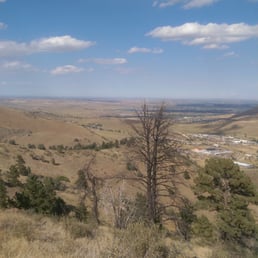
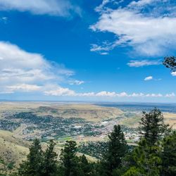
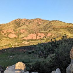
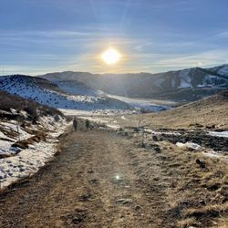
Mt. Galbraith is in the Jefferson County Open Space. This is a hiker only destination. Dogs allowed on leash. It boasts of nearly five miles of rocky trails with commanding views of the Golden, the plains and the Continental Divide. The Mt. Galbraith Loop circles 1.6 miles around the top of the 7,260-foot peak. On one side of the mountain is Clear Creek Canyon and on the other Golden Gate Canyon which were vital passageways into the Central Rockies for Native American Indians and settlers. Miners climbed the mountain to access the western territory during the California Gold Rush. I started at the parking lot trail called Cedar Gulch and flinished it with a loop. Aside from a few little hills this trail is easy but rocky. Total miles if you decide to do the loop is about 5.6. Signage are clear but no distance is indicated. A few natural overlook is a good time to stop to admire the vista. I stopped at a point in the Cedar Gulch Trail and faced the North Table Mountain right across from me and Golden Gate Canyon. Awesome! The Nitghtbird Gulch Trail will provide you with the view of the city of Golden. The loop will give you the best of all the above in all directions. There is a bathroom in the parking lot. You will begin your trail right next to a bubbling creek. Very relaxing start.

The hike here at Mt Galbraith is lovely. Came here one Sunday evening with a friend. The hike was great (not for the faint hearted). The hike took around 2 hours to complete. From a calorie standpoint, I lost around 900 calories from the hike. The parking lot is clean, and there was lots of available spots when I was there. From what I heard, you should come here no later than 1 hour before sunset, or you could find yourself lost up the trail. If your looking for a trail close to Denver, this is your place to come!

This is a great trail - a good portion of it being a steady incline uphill. You get great views on the backside of the mountain (especially if you're around during sunset). The only reason I give this trail 3 stars only is because it's v busy on the weekends. It's close to Denver, so duh. My favorite time to use this trail is on a weekday evening, after-work hours.

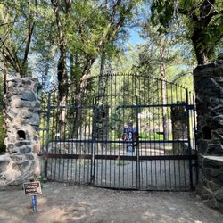
This was a beautiful hike. The trails were single track but because it is hiker only, no worries about jumping out of the way every time someone screams, "On your left!" Much more relaxing than other hiking areas with narrow trails that allow biking. There were a lot of "volunteer trails" that made things a little confusing. These trails just got worse and worse as I followed them. The main trails were good quality. However, I did get lost trying to do the Mount Galbraith loop. At a certain point, it became rocky with no cairns and lots of spur, volunteer trails. I probably could have figured it out but it became tedious and I just turned around. The parking lot off of Golden Gate was small. I suggest backing into the parking spaces if possible, because it can get packed, making it hard to back out of a space. Compost toilets at the entrance. Great hike!

Mt Galbraith Park has a trailhead where you can hike several trails. We did the Gulch trail out and back 3 miles, but had the snow been melted, we would have continued farther. If going when the mountains have snow, make sure you have a hiking stick and spikes. Some very slick parts and a few falls in our party. Looking forward to going back in Spring.

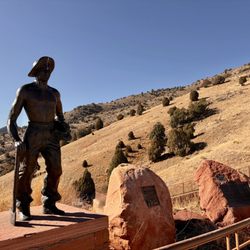
Cedar Gulch Hike: Located 25-30 minutes from Denver, the Mt. Galbraith Loop is a fun moderate day hike. The rocky trail features panoramic views of the surrounding canyons, forest and city of Golden. Hikers can enjoy breathing in the area's fresh air and climbing approximately 1,100 feet to Mt. Galbraith's 7,260 foot peak. The Cedar Gulch trail starts off near a shaded tree area and continues via switch backs up the hill. However, as the trail continues the shade disappears as trail continues up the hill. About 1.7 miles into the hike, the trail splits. It's possible to go left or right, as the trail loops around the hill. The #GoHikeIt team went left up the mountain, which featured views of downtown Golden, before reaching the Mt. Galbraith's summit. After the summit, the trail features a shaded trail forest area. As a Golden hike, the area has its roots mined in gold history. In fact, during the height of the Gold Rush in the mid 1800s, gold miners climbed the mountain as it was more accessible than the area's drainages as they made their way west. Tip: Bring excellent hiking shoes or well protected shoes as sections of the trail are very rocky. Estimated Time: 2 hours

THIS HIKE IS NOT FOR PEOPLE WHO THINK THEYRE GOING ON AN EASY HIKE FOR INTERMEDIATE HIKERS. Lovely hike at certain points when I wasn't basically dying from how tough this hike can be, especially for people who still have some issues with elevation. This hike wasn't my choice however the hiking site is very misleading. No where does it say anything about if the hard trail being on the left.. it's about 1hr up (depending) it SUCKED. None of us knew, and it was the most terrible way to go if you're already exhausted or if have extreme struggles with climbing and exerting yourself more than you should being a Colorado beginner. Avid hikers will have no problems really. I think this hike should be labeled moderate hard. If you take the wrong trail this is what you may experience... climbing up rocks at a very crazy slope. (I fell twice) inclines are insane and sketchy and the path are mostly super narrow. The down hill inclines aren't very safe do to loose rocks and angled trail and wide open cliff.. Some views are nice, but definitely not worth what we went through, however once were more acclimated I think this hike will be a good one. It is busy, but wasn't as busy when we arrived in a Sunday mid morning. You do have to move over for others a lot. That didn't bother us. No wildlife that we saw or rattle snakes, but pretty awesome rocks! There were more shaded sports then we were told so that was great! Our 4mile hike turned into a 7mile hike. I'm just here to help others who are just starting colorado hikes. Just read reviews and a tad research before making your choice it's a pretty tough hike.

Come take a quick 1.6 mile hike to the top of Mt. Galbraith. This 7,260 ft mountain boasts magnificent view of Clear Creek Canyon and Golden Gate Canyon as well as the town of Golden. First time hikers should wear light colored loose fitting clothing such as shorts and a t-shirt in summer weather. Apply a generous coating of sun block lotion over exposed skin and bring plenty of water. The wearing of hiking boots or other sturdy footwear is recommended since this is a rocky and narrow dirt trail. A round trip hike to the top and back will take approximately two hours for the physically fit. The parking area is very small, so arrive early!

This is a pretty moderate - difficult hike. The terrain is very rocky and when there's ice its pretty much impossible. Pros: -Close to Denver -Parking easy -Bathrooms at trail head -Views to Denver, Golden, and everything in between -Good mix of shady evergreens and rocky desert like conditions with cacti Cons: -Heavily trafficked -People right up on you - rude - just say "excuse me" and go around -Dogs everywhere - and their poop bags left along the trail - seriously people, pick it up -Some degenerate spray painted teal hearts everywhere along the trail on the side of rocks -Didn't see any wildlife - I suspect because of all of the above
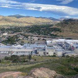
For its close proximity, you truly can't beat it. A 15 minute drive from my house is an absolute win. On a warm weekend, you probably won't score a spot at the parking lot. I'd say 25-30 spots? Keep in mind, this trailhead is POPPING. It's always busy, so know before you go. You can park at different places roadside, which will add to your hike total. The hiking trail is narrow, at times rocky, but mostly dirt. There are some nice views. If you're looking for a serene hike though, this definitely isn't it. I can't tell you the last time I encountered over 100 people on a hike. But again, it makes sense considering where it is. You get some nice views of the Great Divide and even the Coors brewery. There's not much shade, so sunscreen and a hat are a must. I'd probably do this hike again in the winter to avoid the crowds. It's one of the closest hikes to Denver and for the people who've never hiked a mountain I'm sure they'd love doing this one. read more
 - Hiking Near Me - Golden, Colorado")
 - Hiking Near Me - Golden, Colorado")
 - Hiking Near Me - Golden, Colorado")
 - Hiking Near Me - Golden, Colorado")
 - Hiking Near Me - Golden, Colorado")
 - Hiking Near Me - Golden, Colorado")
 - Hiking Near Me - Golden, Colorado")
 - Hiking Near Me - Golden, Colorado")
 - Hiking Near Me - Golden, Colorado")
 - Hiking Near Me - Golden, Colorado")


1 year ago
1 year ago
Nice park in golden. We took the night bird Gulch trail so you park in the neighborhood and do a bit of a hike to get to the park. It's a bit steep but not too bad. Definitely a moderate hike. Definitely recommend for the area and great views of golden. read more


2 years ago
Lovely hike in Golden with spectacular views of Golden and Denver. Small nice parking lot with a bathroom ( hold your nose). Hike consists of Cedar Gulch which is an in and out. Which leads to the Mount Galbraith loop. You can also extend the hike by adding the Night bird in and out loop. Total if you decide on all is roughly 7 miles and about 1700 feet elevation climb. If you decide on the Cedar and Galbraith it is 4 plus miles and 900 feet. The trail is a moderately challenging trail with some rocks you will have to hike over. The trail is impeccably maintained and marked. Dogs and Hikers only. read more


3 years ago
6 years ago
This was one of my favorite hikes we did on Colorado. It's within a 10 minute drive of Golden which makes it very convenient. We got there around 6:45am since I read the parking lot fills up early. We got a spot, but the parking lot was full along with cars being parked halfway down the street when we got back. We hiked the Cedar Gulch Trail to the Mount Galbraith Loop Trail. It was 4 miles total. The hike had gorgeous views even with the haze from wildfires. It was also pretty easy. I think I saw that it was rated moderate and I would put it on the easier side of moderate. Earlier in the morning, almost everyone we passed had a mask on (and there weren't many people). By the time we were almost done and it was getting more crowded, most of the newcomers were not wearing masks. The weather was perfect for us since we left early. It wasn't hot yet and I didn't need sunscreen. There was definitely a lot of sunny parts of the trail though. We even saw a baby rattlesnake towards the end of our hike. If you're looking for a relatively easy hike with amazing views, it doesn't get much better than this. read more


Mt. Galbraith is in the Jefferson County Open Space. This is a hiker only destination. Dogs allowed on leash. It boasts of nearly five miles of rocky trails with commanding views of the Golden, the plains and the Continental Divide. The Mt. Galbraith Loop circles 1.6 miles around the top of the 7,260-foot peak. On one side of the mountain is Clear Creek Canyon and on the other Golden Gate Canyon which were vital passageways into the Central Rockies for Native American Indians and settlers. Miners climbed the mountain to access the western territory during the California Gold Rush. I started at the parking lot trail called Cedar Gulch and flinished it with a loop. Aside from a few little hills this trail is easy but rocky. Total miles if you decide to do the loop is about 5.6. Signage are clear but no distance is indicated. A few natural overlook is a good time to stop to admire the vista. I stopped at a point in the Cedar Gulch Trail and faced the North Table Mountain right across from me and Golden Gate Canyon. Awesome! The Nitghtbird Gulch Trail will provide you with the view of the city of Golden. The loop will give you the best of all the above in all directions. There is a bathroom in the parking lot. You will begin your trail right next to a bubbling creek. Very relaxing start. read more


8 years ago
The hike here at Mt Galbraith is lovely. Came here one Sunday evening with a friend. The hike was great (not for the faint hearted). The hike took around 2 hours to complete. From a calorie standpoint, I lost around 900 calories from the hike. The parking lot is clean, and there was lots of available spots when I was there. From what I heard, you should come here no later than 1 hour before sunset, or you could find yourself lost up the trail. If your looking for a trail close to Denver, this is your place to come! read more


This is a great trail - a good portion of it being a steady incline uphill. You get great views on the backside of the mountain (especially if you're around during sunset). The only reason I give this trail 3 stars only is because it's v busy on the weekends. It's close to Denver, so duh. My favorite time to use this trail is on a weekday evening, after-work hours. read more


This was a beautiful hike. The trails were single track but because it is hiker only, no worries about jumping out of the way every time someone screams, "On your left!" Much more relaxing than other hiking areas with narrow trails that allow biking. There were a lot of "volunteer trails" that made things a little confusing. These trails just got worse and worse as I followed them. The main trails were good quality. However, I did get lost trying to do the Mount Galbraith loop. At a certain point, it became rocky with no cairns and lots of spur, volunteer trails. I probably could have figured it out but it became tedious and I just turned around. The parking lot off of Golden Gate was small. I suggest backing into the parking spaces if possible, because it can get packed, making it hard to back out of a space. Compost toilets at the entrance. Great hike! read more

Mt Galbraith Park has a trailhead where you can hike several trails. We did the Gulch trail out and back 3 miles, but had the snow been melted, we would have continued farther. If going when the mountains have snow, make sure you have a hiking stick and spikes. Some very slick parts and a few falls in our party. Looking forward to going back in Spring. read more

9 years ago
Cedar Gulch Hike: Located 25-30 minutes from Denver, the Mt. Galbraith Loop is a fun moderate day hike. The rocky trail features panoramic views of the surrounding canyons, forest and city of Golden. Hikers can enjoy breathing in the area's fresh air and climbing approximately 1,100 feet to Mt. Galbraith's 7,260 foot peak. The Cedar Gulch trail starts off near a shaded tree area and continues via switch backs up the hill. However, as the trail continues the shade disappears as trail continues up the hill. About 1.7 miles into the hike, the trail splits. It's possible to go left or right, as the trail loops around the hill. The #GoHikeIt team went left up the mountain, which featured views of downtown Golden, before reaching the Mt. Galbraith's summit. After the summit, the trail features a shaded trail forest area. As a Golden hike, the area has its roots mined in gold history. In fact, during the height of the Gold Rush in the mid 1800s, gold miners climbed the mountain as it was more accessible than the area's drainages as they made their way west. Tip: Bring excellent hiking shoes or well protected shoes as sections of the trail are very rocky. Estimated Time: 2 hours read more


6 years ago
THIS HIKE IS NOT FOR PEOPLE WHO THINK THEYRE GOING ON AN EASY HIKE FOR INTERMEDIATE HIKERS. Lovely hike at certain points when I wasn't basically dying from how tough this hike can be, especially for people who still have some issues with elevation. This hike wasn't my choice however the hiking site is very misleading. No where does it say anything about if the hard trail being on the left.. it's about 1hr up (depending) it SUCKED. None of us knew, and it was the most terrible way to go if you're already exhausted or if have extreme struggles with climbing and exerting yourself more than you should being a Colorado beginner. Avid hikers will have no problems really. I think this hike should be labeled moderate hard. If you take the wrong trail this is what you may experience... climbing up rocks at a very crazy slope. (I fell twice) inclines are insane and sketchy and the path are mostly super narrow. The down hill inclines aren't very safe do to loose rocks and angled trail and wide open cliff.. Some views are nice, but definitely not worth what we went through, however once were more acclimated I think this hike will be a good one. It is busy, but wasn't as busy when we arrived in a Sunday mid morning. You do have to move over for others a lot. That didn't bother us. No wildlife that we saw or rattle snakes, but pretty awesome rocks! There were more shaded sports then we were told so that was great! Our 4mile hike turned into a 7mile hike. I'm just here to help others who are just starting colorado hikes. Just read reviews and a tad research before making your choice it's a pretty tough hike. read more


10 years ago
Come take a quick 1.6 mile hike to the top of Mt. Galbraith. This 7,260 ft mountain boasts magnificent view of Clear Creek Canyon and Golden Gate Canyon as well as the town of Golden. First time hikers should wear light colored loose fitting clothing such as shorts and a t-shirt in summer weather. Apply a generous coating of sun block lotion over exposed skin and bring plenty of water. The wearing of hiking boots or other sturdy footwear is recommended since this is a rocky and narrow dirt trail. A round trip hike to the top and back will take approximately two hours for the physically fit. The parking area is very small, so arrive early! read more


This is a pretty moderate - difficult hike. The terrain is very rocky and when there's ice its pretty much impossible. Pros: -Close to Denver -Parking easy -Bathrooms at trail head -Views to Denver, Golden, and everything in between -Good mix of shady evergreens and rocky desert like conditions with cacti Cons: -Heavily trafficked -People right up on you - rude - just say "excuse me" and go around -Dogs everywhere - and their poop bags left along the trail - seriously people, pick it up -Some degenerate spray painted teal hearts everywhere along the trail on the side of rocks -Didn't see any wildlife - I suspect because of all of the above read more


Wow, just got off a plane, this hike is just what we needed. I starTed off a little dizzy. After about 45 minutes we started gettiing aclimated to the altitude. excelent views of Golden to be had. Once you get to the loop things started to cool off. Perfect timing. read more

Mt. Galbraith is a great place to squeeze in a hike if you want to get a good workout and stay close to the city. I did the Mount Galbraith Loop and Cedar Gulch Trail for a total of 4.2mi. Parking is pretty limited here, so if you're coming on a weekend you may have to park along Golden Gate Canyon Rd, make sure you keep your eyes open for the sign along the road, you will get a ticket if you park in the wrong spot. There are restrooms available at the trailhead. Dogs are also permitted on this trail, remember to poop and scoop, plenty of bags available at the trailhead! read more


10 years ago
Great, moderate hiking trail. Parking gets full fairly quickly. Easy access from canyon road. Beautiful view of golden near the top of loop. Definitely be careful after snow has fallen as trail is narrow at certain points. read more


10 years ago
Lovely park that is fantastically accessible from the city. Has a simple trail system but be aware that there is apparently a sub-loop that may take you up to the summit, which is a great view and fun quick jaunt, just probably unauthorized. Due to snow, we couldn't tell where to go and ended up taking this sub-loop to the summit and definitely enjoyed it. The main loop trail gives you many different scenic views, and around sundown it was so peaceful and quiet, that you can forget how close the city is. I'll definitely be back in the summer for quick getaways. read more


9 years ago
9 years ago
More info about Mt. Galbraith Park
21992 Golden Gate Canyon Rd
Golden, CO 80403
Directions
Hours
Indoor Amenities
Outdoor Amenities
Ask the Community - Mt. Galbraith Park
Used the Yelp app for directions to Mt. Galbraith Park today. I wound up in a residential area with only side street parking. Found the park just fine. Wondering where the parking lot is that others are talking about?
Review Highlights - Mt. Galbraith Park
You might also consider


Why does Yelp recommend reviews?
1 review that is not currently recommended
The reviews below are not factored into the business's overall star rating.
8 years ago
Mt. Galbraith Park - hiking - Updated July 2026
Best of Golden
People found Mt. Galbraith Park by searching for…
Scenic View in Golden, Colorado
Sunset View in Golden, Colorado
Scenic Drive in Golden, Colorado
Lookout Points in Golden, Colorado
Scenic Overlook in Golden, Colorado
Hiking Trails With Waterfalls in Golden, Colorado
Off Leash Dog Hikes in Golden, Colorado
Watch Sunset in Golden, Colorado
Fishing Spots in Golden, Colorado
Easy Hikes in Golden, Colorado
Public Running Track in Golden, Colorado
Beautiful Views in Golden, Colorado
Night Hike in Golden, Colorado
Off Road Trails in Golden, Colorado
Walking Trails in Golden, Colorado
Parks With Shade in Golden, Colorado
Free Things to Do With Kids in Golden, Colorado
Skyline View in Golden, Colorado
Natural Hot Springs in Golden, Colorado
Secluded Spots in Golden, Colorado
Dog Swimming in Golden, Colorado
Trending Searches in Golden, CO
4th Of July Fireworks near Mt. Galbraith Park
Baseball Fields near Mt. Galbraith Park
Black Owned Nail Salons near Mt. Galbraith Park
Boardwalk near Mt. Galbraith Park
Boat Rental near Mt. Galbraith Park
Cliff Jumping near Mt. Galbraith Park
Day Trips near Mt. Galbraith Park
Dog Friendly Beaches near Mt. Galbraith Park
Fireworks near Mt. Galbraith Park
Fishing Spots near Mt. Galbraith Park
Free Picnic Areas near Mt. Galbraith Park
Jet Ski Rental near Mt. Galbraith Park
Kayak Rental near Mt. Galbraith Park
Kids Activities Outdoor near Mt. Galbraith Park
Lakes & Ponds near Mt. Galbraith Park
Off Road Trails near Mt. Galbraith Park
Outdoor Activities near Mt. Galbraith Park
Outdoor Basketball Courts near Mt. Galbraith Park
Paddle Boat Rentals near Mt. Galbraith Park
Parks For Picnics near Mt. Galbraith Park
Places To Walk Around near Mt. Galbraith Park
Public Pools near Mt. Galbraith Park
Public Shower near Mt. Galbraith Park
River Swimming near Mt. Galbraith Park
Rock Quarry near Mt. Galbraith Park
Scenic Night View near Mt. Galbraith Park
Scenic Overlook near Mt. Galbraith Park
Secluded Spots near Mt. Galbraith Park
Soccer Store near Mt. Galbraith Park
Splash Pad near Mt. Galbraith Park
Strawberry Picking near Mt. Galbraith Park
Sunrise View near Mt. Galbraith Park
Swimming Holes near Mt. Galbraith Park
Swimming Lakes near Mt. Galbraith Park
View Fireworks near Mt. Galbraith Park
Watch Sunset near Mt. Galbraith Park
Browse Nearby
Browse Brands
Related Searches in Golden, CO
Affordable Kayak Rental Services in Golden, Colorado
Best Fishing Locations and Guides in Golden, Colorado
Best Nature Trails for Hiking in Golden, Colorado
Best Off Leash Dog Parks in Golden, Colorado
Best Parks for Parties and Events in Golden, Colorado
Best Places for Horseback Riding in Golden, Colorado
Best Water Parks for Kids in Golden, Colorado
Check Out Great Playgrounds in Golden, Colorado
Check Out Off Road Trails in Golden, Colorado
Discover Baseball Fields Around Golden, Colorado
Discover Beautiful Garden Spots in Golden, Colorado
Discover Dog Friendly Trails to Explore in Golden, Colorado
Discover Fun Toddler Parks in Golden, Colorado for Your Little One
Discover Kid Friendly Hiking Trails in Golden, Colorado
Discover Lakes & Ponds to Explore in Golden, Colorado
Discover Popular Photo Spots in Golden, Colorado
Discover Scenic Bike Paths in Golden, Colorado
Discover Scenic Mountain Bike Trails Near Golden, Colorado
Discover Scenic Waterfall Spots in Golden, Colorado
Discover Soccer Fields in Golden, Colorado Near You
Discover Top Nature Parks to Visit in Golden, Colorado
Discover Top Scenic Spots to Visit in Golden, Colorado
Discover Top State Parks to Visit in Golden, Colorado
Discover the Best Beaches in Golden, Colorado
Discover the Best Kids Park Spots in Golden, Colorado
Discover the Best Night Hike Trails in Golden, Colorado
Enjoy Camping Adventures Around Golden, Colorado
Enjoy Exciting Mountain Biking Adventures in Golden, Colorado
Enjoy Kayaking Adventures in Golden, Colorado
Enjoy River Tubing Adventures in Golden, Colorado
Enjoy Tent Camping Spots Around Golden, Colorado
Enjoy Water Activities and Fun in Golden, Colorado
Enjoy a Beautiful Waterfall Hike in Golden, Colorado
Enjoy the Best Picnic Spots and Ideas in Golden, Colorado
Enjoy the Best Walking Path in Golden, Colorado
Enjoy the Best Walking Trails in Golden, Colorado
Exciting Cliff Jumping Spots in Golden, Colorado
Experience Thrilling White Water Rafting in Golden, Colorado
Explore Beautiful Botanical Gardens in Golden, Colorado
Explore Beautiful Parks and Green Spaces in Golden, Colorado
Explore Easy Hikes Perfect for All in Golden, Colorado
Explore Family-Friendly Zoos and Wildlife in Golden, Colorado
Explore Free Picnic Areas Around Golden, Colorado
Explore Fun Activities to Do in Golden, Colorado
Explore Parks With Pull Up Bars in Golden, Colorado
Explore Popular Campgrounds Near Golden, Colorado
Explore Popular Picnic Areas Around Golden, Colorado
Explore Popular RV Parks Around Golden, Colorado
Browse Articles
People who viewed Mt. Galbraith Park also viewed
Corwina Park
4 reviews
Mt. Sanitas Trail
73 reviews
South Table Mountain Trail
8 reviews
Van Bibber Open Space
8 reviews
Bear Creek Canyon Park
2 reviews
Lookout Mountain Nature Center
11 reviews
Green Mountain Trail
8 reviews
Crater Lakes
8 reviews
Lookout Mountain Park
103 reviews
Mount Blue Sky Scenic Byway
79 reviews