Nickel Plate Trail Photos


More like Nickel Plate Trail
Recommended Reviews - Nickel Plate Trail
Start your review...

Reviews With Photos

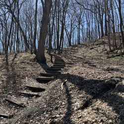
I rode the Nickel Plate Trail from Kokomo to Peru and back, the southern half of the trail. The southern half of the trail is almost completely tree covered and I was in the shade until the sun was directly overhead. I followed up riding the northern half of the trail from Peru to Rochester and back. This segment is even more rural. There were no services north of Peru - no gas stations, restaurants, not even a porta-john. The nearest places were on US31 about 1 mile from the trail. I packed extra water and lunch. The first ~6 miles north of Peru have a tree canopy and after that there are consistently trees on the east side so you can expect shade in the morning and full sun in the afternoon. Peru was a nice lunch stop with a Wendy's, Arby's, and other choices right next to the trail. There's a small shelter with two bench seats in Peru where I had lunch. The trail is well maintained with only a couple of rough spots. The trailhead on the north side of Kokomo has porta-johns. Beyond that you might be looking for gas stations or restaurants to find a bathroom. There's a gas station in Peru with a sign on the trail inviting trail users to stop for snacks and a bathroom break. I found the route through Peru to be easy to follow. There are bike route marks painted on the road. The roads in Peru were very light traffic and felt safe except for the brief time on Broadway. I rode on the sidewalk on Broadway. The route on 7th St is a wide residential street with light traffic. The fall color was great and traffic both on the trail and crossroads was very light on a weekday. Riding on the trail with leaves on a nice fall day is wonderful. Fantastic trail - could use more services like access to bathrooms and water - plan ahead.

1 year ago
Much gratitude for the daily care and maintenance in keeping this trail clear and salt-free for both 2 and 4-legged visitors. read more


5 years ago
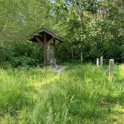
I'm a definite fan of the Nickel Plate Trail, an Indiana rail-trail running from Kokomo to Rochester - approximately 37 miles of nicely paved trail that is perfectly appropriate for walkers, runners, wheelers, and bikers. By now, you likely already know that I spend a good amount of time on trails as part of my activism and traveling by wheelchair. I look for lengthy trails that are well connected to city areas where I can make appearances for fundraising, awareness, and outreach. The Nickel Plate Trail goes through cities including Kokomo, Peru, and Rochester. This allowed me to stop in each city and do some significant outreach. If you visit the Peru area, for example, you'll see a fairly new accessible park for which my Tenderness Tour (the name of my event) made a donation. I've built ongoing relationships from the connections I made on the trail and actually still work quite a bit in both the Rochester and Peru areas. I've spoken in Maconaquah Schools, an area not far from the trail. I actually thought I'd already written this review, but when I discovered a photo from my trip that I wanted to post I realized I'd never actually written this review. If there's a major deficit on this trail, it's a significant lack of restroom availability. As someone who was largely traveling by wheelchair, that's a serious need and it definitely caused some hassles. The only place where they have truly available restrooms are in Peru - there's a trailhead/parking area at the First Bank of Berne that offers nearby public restrooms. Other than that, you definitely have to leave the trail to find anything - and you'll be somewhat lucky if you do. For 37 miles of trail, restrooms just plain make sense and the lack of restrooms take this from a 5-star to a 4-star trail. Otherwise, this is a beautiful trail and I'd be stunned if you don't see wildlife on it. Town highlights include: Rochester, Indiana is known as "The Round Barn Capital of the World." It has Lake Manitou (beautiful). Grab lunch at The Dam Landing (They sponsored my Tenderness Tour). Rochester is a small, friendly town. Macy is a cute small town that was developed in 1860 along with the railroad in the area. It was originally known as Lincoln, however, they had to change their name because there was already a nearby Lincoln (word didn't travel fast in 1860). Deedsville is, well, a small town. I like to pretend it's named after Mr. Deeds, but I'm just pretending. I suppose it could be named after a Mister Deeds. Peru is also a very cool city. It's known as the "Circus Capital of the World." It was the birthplace of Cole Porter. You don't know Cole Porter? Go look him up. I'll wait. Back? This is also home to the Miami Indians (This is a Native American tribe - NOT a sports team. Geez. Get with it.). The independent film Little Big Top was shot here. Bunker Hill's a great little town and home to Maconaquah Schools along with Grissom Air Museum. There's also a lot of auto racing around here. Miami is an unincorporated town - whenever I wheel through it, I have my friend blare Will Smith's "Miami." I don't think he was singing about this one, though. Kokomo is known as the "City of Firsts" as the city has had an extraordinary history with technical innovations. My outreach history is kind of weak here, but I like visiting the city. You should go to the Elwood Haynes Museum, though I can't lie - it makes me think of Elwood Blues. At various points, you can connect into other trails. They're also working on expanding Nickel Plate. In many ways, it reminds me of the Cardinal Greenway minus actual restrooms (Can you tell the restroom thing bugs me?). The trail is for the most part fairly level with gentle inclines/declines and really nice paving the entire way. When you're in the cities, you'll definitely experience people along the way. You'll also get your fair share of rural trail, though it's still nicely paved. There's no question this is one of Indiana's best trails. I look forward to returning to it in the near future. read more


6 years ago
We've been finding a variety of ways to fill our time with free age social distancing friendly fun during the last few months. Today we hopped on the Nickel Plate Trail for the first time and biked 30+ miles between Kokomo and Peru and back. This paved rail to trail also reaches to Noblesville and Westfield as well as further north beyond Peru. The trail we experienced between Kokomo and Peru was well marked and boasted benches and signage throughout. We especially enjoyed one of the picnic benches we found when the river weaves close to the trail. Our adventure was filled with little moments of nature including a snake, chipmunks and rabbits. At the trailhead in Kokomo, you'll find around ten parking spots, a large trail map, trash receptacles and two porta potties. Happy trails, friends! read more

I rode the Nickel Plate Trail from Kokomo to Peru and back, the southern half of the trail. The southern half of the trail is almost completely tree covered and I was in the shade until the sun was directly overhead. I followed up riding the northern half of the trail from Peru to Rochester and back. This segment is even more rural. There were no services north of Peru - no gas stations, restaurants, not even a porta-john. The nearest places were on US31 about 1 mile from the trail. I packed extra water and lunch. The first ~6 miles north of Peru have a tree canopy and after that there are consistently trees on the east side so you can expect shade in the morning and full sun in the afternoon. Peru was a nice lunch stop with a Wendy's, Arby's, and other choices right next to the trail. There's a small shelter with two bench seats in Peru where I had lunch. The trail is well maintained with only a couple of rough spots. The trailhead on the north side of Kokomo has porta-johns. Beyond that you might be looking for gas stations or restaurants to find a bathroom. There's a gas station in Peru with a sign on the trail inviting trail users to stop for snacks and a bathroom break. I found the route through Peru to be easy to follow. There are bike route marks painted on the road. The roads in Peru were very light traffic and felt safe except for the brief time on Broadway. I rode on the sidewalk on Broadway. The route on 7th St is a wide residential street with light traffic. The fall color was great and traffic both on the trail and crossroads was very light on a weekday. Riding on the trail with leaves on a nice fall day is wonderful. Fantastic trail - could use more services like access to bathrooms and water - plan ahead. read more


6 years ago
The Nickel Plate is a nice trail that connects Kokomo to Rochester (at this point.) Well kept, good amounts of shady sections, a few challenging hills (for recumbents). Biggest con, is it needs more port-o-pots and easier guides through kokomo and Peru. read more
More info about Nickel Plate Trail
Peru, IN 46970
Directions
Visit Website
http://www.nickelplatetrail.org/map/
Hours
Outdoor Amenities


Nickel Plate Trail - hiking - Updated May 2026
Best of Peru
People found Nickel Plate Trail by searching for…
Hiking Trails in Peru, Indiana
Lakes & Ponds in Peru, Indiana
Beautiful Views in Peru, Indiana
Running Trails in Peru, Indiana
Walking Trails in Peru, Indiana
Off Leash Dog Hikes in Peru, Indiana
Free Campgrounds in Peru, Indiana
Natural Hot Springs in Peru, Indiana
Scenic Overlook in Peru, Indiana
Free Picnic Areas in Peru, Indiana
Trending Searches in Peru, IN
Baseball Fields near Nickel Plate Trail
Botanical Gardens near Nickel Plate Trail
Bounce House Rentals near Nickel Plate Trail
Campgrounds near Nickel Plate Trail
Floral Designers near Nickel Plate Trail
Flower Shop near Nickel Plate Trail
Garage Sales near Nickel Plate Trail
Garden Center near Nickel Plate Trail
Lakes & Ponds near Nickel Plate Trail
Mens Suits near Nickel Plate Trail
Mexican Catering near Nickel Plate Trail
Nurseries & Gardening near Nickel Plate Trail
Outdoor Furniture Stores near Nickel Plate Trail
Party Equipment Rentals near Nickel Plate Trail
Pedicure near Nickel Plate Trail
Photo Spots near Nickel Plate Trail
Picnic Areas near Nickel Plate Trail
Plant Nursery near Nickel Plate Trail
Browse Articles
Browse Nearby
BEST of Peru, Indiana Restaurants near Nickel Plate Trail
BEST of Peru, Indiana Coffee near Nickel Plate Trail
BEST of Peru, Indiana Parks near Nickel Plate Trail
BEST of Peru, Indiana Things to Do near Nickel Plate Trail
BEST of Peru, Indiana Photo Spots near Nickel Plate Trail
BEST of Peru, Indiana Breakfast near Nickel Plate Trail
BEST of Peru, Indiana Campgrounds near Nickel Plate Trail
Browse Brands
Related Searches in Peru, IN
Best Fishing Locations and Guides in Peru, Indiana
Best Nature Trails for Hiking in Peru, Indiana
Best Spots for Star Gazing in Peru, Indiana
Check Out Off Road Trails in Peru, Indiana
Discover Baseball Fields Around Peru, Indiana
Discover Popular Bike Trails in Peru, Indiana
Discover Popular Photo Spots in Peru, Indiana
Discover a Hiking Trail in Peru, Indiana
Discover the Best Running Track in Peru, Indiana
Effective Stairs Workout Spots in Peru, Indiana
Enjoy Scenic Night View Experiences in Peru, Indiana
Enjoy the Best Walking Trails in Peru, Indiana
Experience Stunning Sunset Views in Peru, Indiana
Explore Beautiful Parks and Green Spaces in Peru, Indiana
Explore Easy Hikes Perfect for All in Peru, Indiana
Explore Free Things to Do Around Peru, Indiana
Explore Fun Activities to Do in Peru, Indiana
Explore Popular Campgrounds Near Peru, Indiana
Explore Scenic Lakes to Visit in Peru, Indiana
Explore Secret Spots Worth Visiting in Peru, Indiana
Explore Top Dog Parks in Peru, Indiana Near You
Explore Volleyball Courts Available in Peru, Indiana
Explore the Best Boating Spots in Peru, Indiana
Find Beautiful Views in Peru, Indiana
Find the Best Playgrounds to Visit in Peru, Indiana
Find the Best Scenic View Locations in Peru, Indiana
Find the Best Swimming Pools in Peru, Indiana Today
Fun Toddler Activities to Try in Peru, Indiana
Have Fun at a Splash Pad in Peru, Indiana
Locate a Public Shower Facility in Peru, Indiana
Must-See Tourist Attractions Around Peru, Indiana
Off Leash Dog Hiking Trails in Peru, Indiana
Plan a Scenic Drive Route Near Peru, Indiana
Play at a Splash Pad Park in Peru, Indiana
Popular Fishing Spots to Explore in Peru, Indiana
Popular Kids Activities in Peru, Indiana
Popular Picnic Spots to Visit in Peru, Indiana
Popular Places to Take Pictures in Peru, Indiana
Popular Things to Do in Peru, Indiana
Popular Things to See in Peru, Indiana
Safe River Swimming Areas in Peru, Indiana
See Top Fireworks Events in Peru, Indiana
Top Paddleboarding Activities in Peru, Indiana
Top Places to Visit in Peru, Indiana for Sightseeing
Top Playgrounds for Kids to Enjoy in Peru, Indiana
Top Running Trails to Explore in Peru, Indiana
Top Swimming Lakes to Enjoy in Peru, Indiana
Top Things to Do With Kids in Peru, Indiana