Little Turtle Waterway Photos


More like Little Turtle Waterway
Recommended Reviews - Little Turtle Waterway
Start your review...

5 years ago
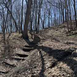
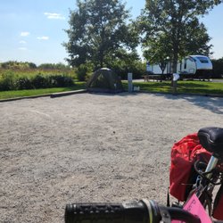
When I'm on one of my Tenderness Tour events, sometimes I'll give myself easier days to give my body a break and to also give myself time to actually visit the cities and towns I wheel through. One such lighter day would be the Little Turtle Waterway Trail, a 1.8 mile asphalt paved trail in Logansport that qualifies as both a rail-trail and a waterway trail. The trail allows walking, biking, rollerblading, and running and is also wheelchair friendly and documented as ADA compliant. The trail has three key features worth visiting - Little Turtle Park, the Wabash River, and the railroad it follows. The river, in particular, is quite beautiful along the route with periodic benches so that you can simply sit and enjoy it. The trail falls under the management of Logansport Parks and Recreation and is well maintained. Logansport has several trails within its city limits including the multi-county Nickel Plate, but if you're wanting to spend some time in Logansport this is a terrific trail to visit. The trail gets its name from the Miami Chief Little Turtle. The primary trailhead is Little Turtle Waterway Plaza, a place that offers parking and will also eventually be a connector to other trails. The trail crosses some bridges over the Wabash and the Cass County Historical Museum is within walking distance of the trail. The trail's East end, near 5th street, offers a dirt trail for hiking or biking. This isn't the most extensive or fanciest trail, but it's rather nice and when everything gets done in this area it may very well turn into a 5-star trail! Since much of the trail is along downtown, you also do have some options for dining and/or restrooms. read more


More info about Little Turtle Waterway
E Melbourne Ave
Logansport, IN 46947
Directions
Hours
Outdoor Amenities


Little Turtle Waterway - hiking - Updated May 2026
Best of Logansport
People found Little Turtle Waterway by searching for…
Things to Do in Logansport, Indiana
Hiking Trails in Logansport, Indiana
Waterfall in Logansport, Indiana
Mountain Biking in Logansport, Indiana
Walking Trails in Logansport, Indiana
Parks and Recreation in Logansport, Indiana
Off Leash Dog Hikes in Logansport, Indiana
Running Trails in Logansport, Indiana
Off Road Trails in Logansport, Indiana
Photo Spots in Logansport, Indiana
Places to Take Pictures in Logansport, Indiana
Landmarks in Logansport, Indiana
Fitness & Instruction in Logansport, Indiana
Waterfalls and Swimming Holes in Logansport, Indiana
Experience in Logansport, Indiana
Places to Run in Logansport, Indiana
Trending Searches in Logansport, IN
Baseball Fields near Little Turtle Waterway
Botanical Gardens near Little Turtle Waterway
Bounce House Rentals near Little Turtle Waterway
Campgrounds near Little Turtle Waterway
Floral Designers near Little Turtle Waterway
Flower Shop near Little Turtle Waterway
Garage Sales near Little Turtle Waterway
Garden Center near Little Turtle Waterway
Hair near Little Turtle Waterway
Lakes & Ponds near Little Turtle Waterway
Mexican Catering near Little Turtle Waterway
Nurseries & Gardening near Little Turtle Waterway
Outdoor Furniture Stores near Little Turtle Waterway
Parks near Little Turtle Waterway
Party Equipment Rentals near Little Turtle Waterway
Pedicure near Little Turtle Waterway
Photo Spots near Little Turtle Waterway
Pick Your Own Farms near Little Turtle Waterway
Picnic Areas near Little Turtle Waterway
Places To Take Pictures near Little Turtle Waterway
Swimming Holes near Little Turtle Waterway
Browse Articles
Browse Nearby
BEST of Logansport, Indiana Coffee near Little Turtle Waterway
BEST of Logansport, Indiana Lakes near Little Turtle Waterway
BEST of Logansport, Indiana Things to Do near Little Turtle Waterway
BEST of Logansport, Indiana Restaurants near Little Turtle Waterway
BEST of Logansport, Indiana Parks near Little Turtle Waterway
BEST of Logansport, Indiana Hotels near Little Turtle Waterway
BEST of Logansport, Indiana Campgrounds near Little Turtle Waterway
BEST of Logansport, Indiana Breakfast near Little Turtle Waterway
BEST of Logansport, Indiana Taxis near Little Turtle Waterway
Browse Brands
Related Searches in Logansport, IN
Best Fishing Locations and Guides in Logansport, Indiana
Best Fun Things to Do in Logansport, Indiana
Best Places for Horseback Riding in Logansport, Indiana
Discover Baseball Fields Around Logansport, Indiana
Discover Lakes & Ponds to Explore in Logansport, Indiana
Discover Popular Bike Trails in Logansport, Indiana
Discover a Hiking Trail in Logansport, Indiana
Discover the Best Night Hike Trails in Logansport, Indiana
Enjoy Exciting Mountain Biking Adventures in Logansport, Indiana
Enjoy the Best Walking Trails in Logansport, Indiana
Explore Beautiful Botanical Gardens in Logansport, Indiana
Explore Beautiful Parks and Green Spaces in Logansport, Indiana
Explore Bike Rentals Throughout Logansport, Indiana
Explore Easy Hikes Perfect for All in Logansport, Indiana
Explore Family-Friendly Zoos and Wildlife in Logansport, Indiana
Explore Free Things to Do Around Logansport, Indiana
Explore Fun Activities to Do in Logansport, Indiana
Explore Popular Campgrounds Near Logansport, Indiana
Explore Popular RV Parks Around Logansport, Indiana
Explore Scenic Lakes to Visit in Logansport, Indiana
Explore Top Dog Parks in Logansport, Indiana Near You
Explore Top Water Parks in Logansport, Indiana Today
Explore Volleyball Courts Available in Logansport, Indiana
Explore the Best Boating Spots in Logansport, Indiana
Family Friendly Hiking With Kids in Logansport, Indiana
Find Beautiful Views in Logansport, Indiana
Find Top Dog Swimming Spots in Logansport, Indiana
Find Top Skate Parks in Logansport, Indiana for All Skill Levels
Find the Best Playgrounds to Visit in Logansport, Indiana
Find the Best Swimming Pools in Logansport, Indiana Today
Fun Toddler Activities to Try in Logansport, Indiana
Have Fun at a Splash Pad in Logansport, Indiana
Hiking Trails With Waterfalls in Logansport, Indiana
Locate a Public Shower Facility in Logansport, Indiana
Off Leash Dog Hiking Trails in Logansport, Indiana
Perfect Spots to Watch Sunset in Logansport, Indiana
Plan a Scenic Drive Route Near Logansport, Indiana
Play at a Splash Pad Park in Logansport, Indiana
Popular Fishing Spots to Explore in Logansport, Indiana
Popular Kids Activities in Logansport, Indiana
Popular Places to Take Pictures in Logansport, Indiana
Popular Things to Do in Logansport, Indiana
Safe River Swimming Areas in Logansport, Indiana
See Top Fireworks Events in Logansport, Indiana
Top Places to Visit in Logansport, Indiana for Sightseeing
Top Running Trails to Explore in Logansport, Indiana
Top Swimming Lakes to Enjoy in Logansport, Indiana
Top Things to Do With Kids in Logansport, Indiana
Top Things to Do With Teenagers in Logansport, Indiana
Top-Rated Basketball Courts to Play at in Logansport, Indiana
People who viewed Little Turtle Waterway also viewed
Foster Park
3 reviews
Nickel Plate Trail
5 reviews
Jackson Marrow Park
3 reviews
Abby & Libby Memorial Park
3 reviews
Wildcat Canoe and Kayak Too
9 reviews
White Rock Recreation
10 reviews
Riley Park - Delphi
3 reviews
Jackson Township Park
1 review
Kokomo Beach Family Aquatic Center
4 reviews
Bachelor Runn Campground
4 reviews