Matanuska Peak Trail Photos


You might also consider
More like Matanuska Peak Trail
Recommended Reviews - Matanuska Peak Trail
Start your review...

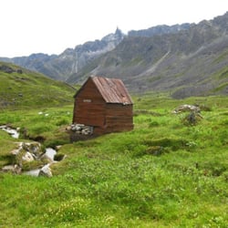
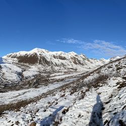
Starting at the trailhead on Smith Road you'll head in on a relatively flat trail. It becomes mostly uphill at the moment that you take a slight left off the ATV trail. Don't worry, it's clearly labeled here and you'll know you're on the right trail because there will be a marker. Around 4600 you'll start to hear rushing water off to your left. Around 5400-5600 you'll hit your first view of Palmer and the Butte/Pioneer off to your left. Mostly uphill until 9800. Then it smooths out in the McRoberts Basin for about two miles. You Lazy Creek at 10800 After you cross the gulch around mile 4, it gets steep and strenuous. The top is just shy of 6 miles. The last marker I saw was 29700. In the future I might mountain bike in 4-5 miles. Or backpack in four miles, set up camp and hike to the summit with a couple water bottles. Certainly worth the views, but the books don't lie. It's a strenuous trail. read more


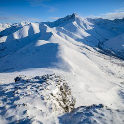
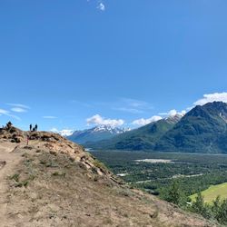
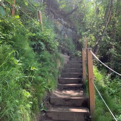
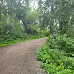
Only on Alaska Yelp can you be first to review a very popular hike! Even if you don't know this peak, you know this peak. It's the "other" prominent peak (besides Pioneer) that looms over Palmer. This is the "big boy" corollary to the neighboring Lazy Mountain trail: https://www.yelp.com/biz/lazy-mountain-trail-head-palmer The trail starts out on a 4x4 road. It's pretty wide with hard packed gravel. Eventually it narrows and gets VERY brushy. Seriously, practice your "HEY BEAR"'s, because the vegetation really overtakes the middle part of this trail. Eventually you'll emerge from the brush and out onto alpine tundra. The trail is the obvious dirty path running through the hills of alpine prairie. Lots of grounds squirrels here. Now you're at the base of Matanuska Peak. Don't be like me. Take a trekking pole. The final 1,000 ft of gain to the summit would be WAY easier with a pole to balance on! Some rock is white and sticky, but lose. Some rock is solid, but covered in black lichen and therefore slippery. Choose your poison! (trail markers guide you up the entire trail, even up through the scree and rock, keep an eye out) The summit is pretty small, you'll definitely get to know the other people on the top. (can get crowded in the summer) Great views of the Chugach: Ice Cream Cone peak, Knik Glacier, Pioneer Peak, Twin Peaks, and the Palmer valley. I found the hike down from the summit to be much easier/faster, but my knees are feeling stronger these days. If you have bad knees...again, get yourself a pole. Stats for this trail: Miles R/T: 8 Elevation gain: 5,670 ft read more


More info about Matanuska Peak Trail


Matanuska Peak Trail - hiking - Updated July 2026
Best of Palmer
People found Matanuska Peak Trail by searching for…
Things to Do in Palmer, Alaska
Secret Spots in Palmer, Alaska
Swimming Lakes in Palmer, Alaska
Walking Trails in Palmer, Alaska
Off Road Trails in Palmer, Alaska
Scenic Overlook in Palmer, Alaska
Picnic Areas in Palmer, Alaska
Hiking Trails in Palmer, Alaska
Running Trails in Palmer, Alaska
Things to Do at Night in Palmer, Alaska
Mountain Biking in Palmer, Alaska
Restaurants With a View in Palmer, Alaska
Playgrounds for Kids in Palmer, Alaska
Tourist Attractions in Palmer, Alaska
Beautiful Views in Palmer, Alaska
Factory Tours in Palmer, Alaska
Things to Do on a Rainy Day in Palmer, Alaska
Canyoneering in Palmer, Alaska
Trending Searches in Palmer, AK
Browse Articles
Browse Brands
Related Searches in Palmer, AK
Affordable Kayak Rental Services in Palmer, Alaska
Best Fishing Locations and Guides in Palmer, Alaska
Best Fun Things to Do in Palmer, Alaska
Best Places for Horseback Riding in Palmer, Alaska
Best Sledding Spots and Fun in Palmer, Alaska
Check Out Off Road Trails in Palmer, Alaska
Discover Dog Friendly Trails to Explore in Palmer, Alaska
Discover Popular Photo Spots in Palmer, Alaska
Discover Top Boat Tours in Palmer, Alaska for All Ages
Discover a Hiking Trail in Palmer, Alaska
Discover the Best Night Hike Trails in Palmer, Alaska
Dog-Friendly Hikes With Dogs in Palmer, Alaska
Enjoy Exciting Mountain Biking Adventures in Palmer, Alaska
Enjoy Kayaking Adventures in Palmer, Alaska
Enjoy the Best Walking Trails in Palmer, Alaska
Explore Beautiful Parks and Green Spaces in Palmer, Alaska
Explore Bike Rentals Throughout Palmer, Alaska
Explore Easy Hikes Perfect for All in Palmer, Alaska
Explore Free Things to Do Around Palmer, Alaska
Explore Fun Activities to Do in Palmer, Alaska
Explore Popular Campgrounds Near Palmer, Alaska
Explore Popular RV Parks Around Palmer, Alaska
Explore Popular Scenic Overlook Points in Palmer, Alaska
Explore Scenic Lakes to Visit in Palmer, Alaska
Explore Secret Spots Worth Visiting in Palmer, Alaska
Explore Top Dog Parks in Palmer, Alaska Near You
Explore Top Water Parks in Palmer, Alaska Today
Explore the Best Boating Spots in Palmer, Alaska
Family Friendly Hiking With Kids in Palmer, Alaska
Find Beautiful Views in Palmer, Alaska
Find the Best Playgrounds to Visit in Palmer, Alaska
Find the Best Scenic View Locations in Palmer, Alaska
Great Places to Swim in Palmer, Alaska
Must-See Tourist Attractions Around Palmer, Alaska
Popular Kids Activities in Palmer, Alaska
Popular Outdoor Activities to Try in Palmer, Alaska
Popular Places to Take Pictures in Palmer, Alaska
Popular Things to Do in Palmer, Alaska
Relax at Natural Hot Springs Near Palmer, Alaska
Safe and Fun Parks for Kids in Palmer, Alaska
See Top Fireworks Events in Palmer, Alaska
Top Climbing Spots and Gyms in Palmer, Alaska
Top Fishing Charter Experiences in Palmer, Alaska
Top Paddleboarding Activities in Palmer, Alaska
Top Playgrounds for Kids to Enjoy in Palmer, Alaska
Top Running Trails to Explore in Palmer, Alaska
Top Swimming Lakes to Enjoy in Palmer, Alaska
Top Things to Do With Kids in Palmer, Alaska
People who viewed Matanuska Peak Trail also viewed
Hatcher Pass State Recreation Area
18 reviews
Archangel Nordic
1 review
Thunderbird Falls Parking Area and Trailhead
39 reviews
Alaska Zipline Adventure Park
6 reviews
Alaska Glacier Experience & Wilderness ATV Tours
12 reviews
Craig Fellin Outfitters & Big Hole Lodge
1 review
49th State Motor Tours
23 reviews
MICA Guides
88 reviews
Hunter Creek Ice Climbs
1 review
Midnight Sun Yoga Center
4 reviews