Hatcher Pass State Recreation Area Photos


You might also consider
More like Hatcher Pass State Recreation Area
Recommended Reviews - Hatcher Pass State Recreation Area
Start your review...

Reviews With Photos

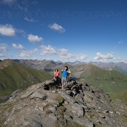
Elevation: 3886 feet, this place is simply majestic. One of my favorite hikes. Located about 90 minutes north of Anchorage, it is worth a special trip, or a detour if you're traveling to/from Denali. A round trip hike to the summit is about 3 miles, with a pretty intense incline. The views of the mountains, lakes, waterfalls and clouds are spectacular and well worth the hike (literally). Stop at the lodge on your way down for a drink or bite to eat, or stay at one of the cabins.


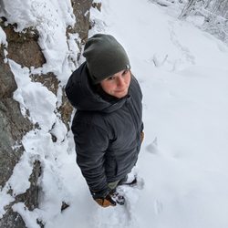
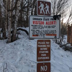
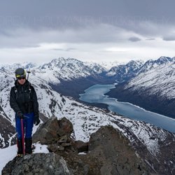
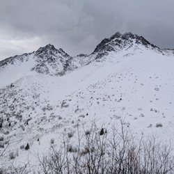
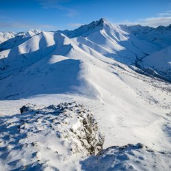
How can you not give nature five stars?! I've wondered that since I've come to the realm of yelp. There's just nothing else for it. Especially when you take into consideration a well maintained road with plenty of helpful signage, and the ranger presence. A popular spot for skiers, snowshoers, and snowboarders this time of year, the road was pretty well traveled today. We even caught a glimpse of a couple dudes making a snowman. We drove up through Hatcher Pass Recreation Area until a point at which a ranger stopped us, and everybody else trying to go up to the top of the mountain. The roads were open but still pretty thick with snow and ice. Not to mention the whole Avalanche warning business. That was a first for this California Girl. It was a warm day by Alaska standards, topping at about 45 degrees Fahrenheit. The view from our stopping point was incredible. I don't even. Have words. We could see down to the valley where I'm currently staying, on the Palmer Wasilla highway. There was a 360 view of mountain peaks, and the overcast sky had the sun shining down through breaks in the cloud coverage. I could have stayed there all day playing in the snow and taking pictures, but mostly just taking it all in. A view like this reaffirms my belief in a higher power. Every time. Even so I don't think I've ever seen mountains like these in my entire life. The Alaska bucket list continues!

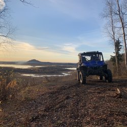
One of the great places to play for folks living in the Anchorage metro. (and in your backyard if you're in Palmer or Wasilla) It's not exactly a state park, but it's close. All types enjoy this area: hunters, hikers, birders, snowmachiners, skiiers, cyclists, and even rock and ice climbers. Access in the winter can be tricky as the roads quickly begin to close to traditional vehicle traffic as the snow starts to fall in....well, in fall. Great place to view the Northern Lights in the winter. There's also some good backcountry skiing but, be warned, avalanche danger can be severe. Make sure you check the forecasts and take proper precautions. Fantastic spot to pick berries and trek between alpine huts in the summer. The place is gorgeous, in a very unique way. It reminds me of the Scottish Higlands. I've never been to them, but I saw some photos and almost mistook them for our Hatcher Pass! Being close to here is perhaps the only thing that could be good about living in Wasilla. Protip: Hey newbs and tourists, it's "Hatcher Pass", NOT "Hatcher's Pass". I just saved you some embarrassment!

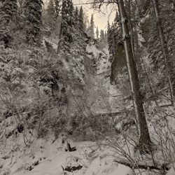
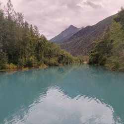
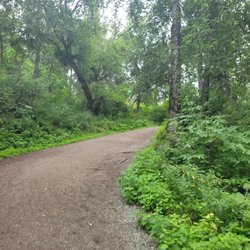
Hatcher Pass has got to be one of your favorite spot to hike so far. The drive there is so pretty with rushing river on the side of the road. There are so many spots for you to pull over, enjoy the scenery and snap a couple of pictures. Once you get to Hatcher Pass, there are multiple hikes to choose from ranging from easy to difficult. Whichever path you choose, it promises to provide exceptional view of snow capped mountains, blue/green lakes, gushing rivers, mesmerizing waterfalls, and treacherous glaciers. Occasionally, some wild rodents chit chatting to break the tranquility near the bottom of the mountains. There are no shortage of things to do here besides hiking and sightseeing. It's a great place for camping, rock climbing, and paragliding. If you're fearless or being "persuaded" by peer pressure, a plunge into the freezing lake is also often observed.


A great place to get a breathtakingly beautiful view and some peace of mind, Hatcher Pass is about 30 minutes outside of Palmer. Great for skiing, sledding, hiking, snowshoeing, etc.! Hatcher Pass is also home to historic Independence Mine and the Independence Mine State Historical Park Visitor Center.

3 years ago
Love this vast area past Wasilla. The drive-in has some of the most beautiful scenery. Hatcher's Pass I believe, will be a left hand turn after you've passed the lodge. The road is pretty narrow and as you elevate, it gets tricky with oncoming traffic, especially if you're in a larger vehicle. We recently visited on a sunny day with lots of traffic. We saw multiple paragliders' take off and land. Many hikers and bikers. The weather was perfect. The lake was unsurprisingly still pretty frozen. read more


2 years ago
Most beautiful experience, good was comforting. Scenery, exemplary! Sitting by a warm fire, eating a very tasty sandwich and hot cocoa what a beautiful memory. read more


8 months ago
Elevation: 3886 feet, this place is simply majestic. One of my favorite hikes. Located about 90 minutes north of Anchorage, it is worth a special trip, or a detour if you're traveling to/from Denali. A round trip hike to the summit is about 3 miles, with a pretty intense incline. The views of the mountains, lakes, waterfalls and clouds are spectacular and well worth the hike (literally). Stop at the lodge on your way down for a drink or bite to eat, or stay at one of the cabins. read more


3 years ago
Absolutely beautiful! This is a must see. So many places to stop and view breathtaking sights. We took several photos that turned out amazing. read more


2 years ago
How can you not give nature five stars?! I've wondered that since I've come to the realm of yelp. There's just nothing else for it. Especially when you take into consideration a well maintained road with plenty of helpful signage, and the ranger presence. A popular spot for skiers, snowshoers, and snowboarders this time of year, the road was pretty well traveled today. We even caught a glimpse of a couple dudes making a snowman. We drove up through Hatcher Pass Recreation Area until a point at which a ranger stopped us, and everybody else trying to go up to the top of the mountain. The roads were open but still pretty thick with snow and ice. Not to mention the whole Avalanche warning business. That was a first for this California Girl. It was a warm day by Alaska standards, topping at about 45 degrees Fahrenheit. The view from our stopping point was incredible. I don't even. Have words. We could see down to the valley where I'm currently staying, on the Palmer Wasilla highway. There was a 360 view of mountain peaks, and the overcast sky had the sun shining down through breaks in the cloud coverage. I could have stayed there all day playing in the snow and taking pictures, but mostly just taking it all in. A view like this reaffirms my belief in a higher power. Every time. Even so I don't think I've ever seen mountains like these in my entire life. The Alaska bucket list continues! read more


One of the great places to play for folks living in the Anchorage metro. (and in your backyard if you're in Palmer or Wasilla) It's not exactly a state park, but it's close. All types enjoy this area: hunters, hikers, birders, snowmachiners, skiiers, cyclists, and even rock and ice climbers. Access in the winter can be tricky as the roads quickly begin to close to traditional vehicle traffic as the snow starts to fall in....well, in fall. Great place to view the Northern Lights in the winter. There's also some good backcountry skiing but, be warned, avalanche danger can be severe. Make sure you check the forecasts and take proper precautions. Fantastic spot to pick berries and trek between alpine huts in the summer. The place is gorgeous, in a very unique way. It reminds me of the Scottish Higlands. I've never been to them, but I saw some photos and almost mistook them for our Hatcher Pass! Being close to here is perhaps the only thing that could be good about living in Wasilla. Protip: Hey newbs and tourists, it's "Hatcher Pass", NOT "Hatcher's Pass". I just saved you some embarrassment! read more


Hatcher Pass has got to be one of your favorite spot to hike so far. The drive there is so pretty with rushing river on the side of the road. There are so many spots for you to pull over, enjoy the scenery and snap a couple of pictures. Once you get to Hatcher Pass, there are multiple hikes to choose from ranging from easy to difficult. Whichever path you choose, it promises to provide exceptional view of snow capped mountains, blue/green lakes, gushing rivers, mesmerizing waterfalls, and treacherous glaciers. Occasionally, some wild rodents chit chatting to break the tranquility near the bottom of the mountains. There are no shortage of things to do here besides hiking and sightseeing. It's a great place for camping, rock climbing, and paragliding. If you're fearless or being "persuaded" by peer pressure, a plunge into the freezing lake is also often observed. read more


5 years ago
A beautiful location convenient to Anchorage, Palmer, and Wasilla. August is a great time of year to hike, view the Little Susitna River, and explore! If you're lucky you might just find some berries that are ripe for picking (late summer). read more


A great place to get a breathtakingly beautiful view and some peace of mind, Hatcher Pass is about 30 minutes outside of Palmer. Great for skiing, sledding, hiking, snowshoeing, etc.! Hatcher Pass is also home to historic Independence Mine and the Independence Mine State Historical Park Visitor Center. read more

3 years ago
13 years ago
6 years ago
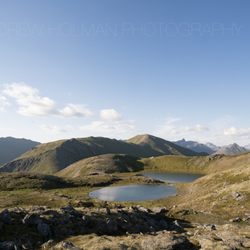
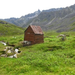
Hatcher Pass, about 20 miles north of Palmer and 50 miles north of Anchorage (but close to my house) is my favorite place in the world. I like to pick blueberries there but in the winter a lot of people ski and snowboard there. The road is very well maintained. It's mainly paved until you start up into the mountains and then it's gravel grade. Around the 4th of July they open the road that goes all the way thru the pass and ends by Houston, Alaska. It can take about 4 hours from start to finish when the road is really bumpy. Is it worth the drive? Here are some pictures..at the top of the pass is Summit Lake. It's a gorgeous glacier lake and by July most of the snow is gone. There are hiking paths galore, most of them easy. This is where I find peace and solace and most people here do too. It's just a quiet, wonderful place with huge mountain vistas and lots of nice streams, flower and fauna. read more


More info about Hatcher Pass State Recreation Area
Hatcher Pass Rd
Fishhook, AK 99645
Directions
Hours
Outdoor Amenities
Ask the Community - Hatcher Pass State Recreation Area
Review Highlights - Hatcher Pass State Recreation Area


Hatcher Pass State Recreation Area - hiking - Updated July 2026
Best of Fishhook
People found Hatcher Pass State Recreation Area by searching for…
Things to Do in Fishhook, Alaska
Campgrounds in Fishhook, Alaska
Scenic Views in Fishhook, Alaska
Playgrounds in Fishhook, Alaska
Places to Take Pictures in Fishhook, Alaska
Off Road Trails in Fishhook, Alaska
Picnic Areas in Fishhook, Alaska
Beautiful Views in Fishhook, Alaska
Gold Panning in Fishhook, Alaska
Walking Trails in Fishhook, Alaska
Visitor Centers in Fishhook, Alaska
Camping Sites in Fishhook, Alaska
Tourist Attractions in Fishhook, Alaska
Hiking Trails in Fishhook, Alaska
Running Trails in Fishhook, Alaska
Photo Spots in Fishhook, Alaska
Scenic Overlook in Fishhook, Alaska
Waterfalls in Fishhook, Alaska
Browse Nearby
Browse Brands
Trending Searches in Fishhook, AK
Browse Articles
People who viewed Hatcher Pass State Recreation Area also viewed
Matanuska River Park
5 reviews
Government Peak Recreation Area
3 reviews
Big Bear Campground & Rv Park
7 reviews
Tippecanoe
8 reviews
Fishhook Trailhead
2 reviews
Matanuska Peak Trail
2 reviews
Alaska Backcountry Adventure Tours
75 reviews
Reindeer Farm
221 reviews
Alaska's Gold Buckle Tours
1 review
Palmer Hay Flats State Game Refuge
1 review