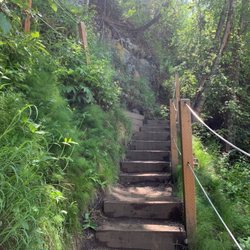
Fishhook Trailhead Photos


You might also consider
More like Fishhook Trailhead
Recommended Reviews - Fishhook Trailhead
Start your review...

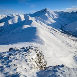
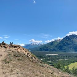
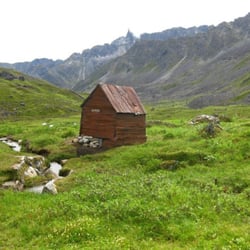
A few notes: 1. The map location on this is wrong. Here is a link to Google Maps. https://goo.gl/maps/2tCGimSECBKfwTj48 2. The trail is called Fishhook on the sign and on Google Maps, but I've also heard of it referred to as Marmot. 3. This trail is rated a variety of ways. It isn't long at 1.3 miles (one way), but it is steep. My Garmin registered 2000 feet of elevation change. I would rate the trail as moderate for distance and technical skills. There are some moments where the trail is pretty narrow. I would rate it as hard for exertion level. Locals will see it as a short and little difficult. Out of towners may view it as hard to expert. 4. Bring sunscreen on sunny days and bug spray if it is not windy. I saw a mosquito the size of a quarter on several occasions. Luckily, it was a bit windy. It is roughly .7 miles to the top of the first rise. Nothing is as steep after the first .7 miles, but the trails does meander up along a ridge until it reaches the top. It took me about 80 minutes to make the summit. I stopped along the way for pictures and taking in the views. Going down was faster, but tough on the toes and the bottoms of my feet. Hiking poles would have made the descent a lot easier on my toes. When I hiked in late June, it was very dusty and sandy. It was easy to lose footing on the ascent and descent if you are not careful. Nearly the whole hike rewards the traveler with 360 degree views of Hatcher and even down in to the Valley to Pioneer. There's a black tube at the top with a journal and pens. Sign your name, write a note. See who has been there before. The last .6 miles included lots of ground squirrels . If you stop and sit for a while, you will almost certainly see them running about, munching on vegetation, or licking rocks. read more


We hiked this in late October. It is absolutely gorgeous, but it's a rigorous hike with very steep parts. There was lots of ice and mud, so we were slipping a LOT. We could not make it to the top. Made it about 3/4 of the way. It was the first hike we haven't finished. read more
More info about Fishhook Trailhead
Fishhook-Willow Rd
Palmer, AK 99645
Directions
Hours
Outdoor Amenities


Fishhook Trailhead - hiking - Updated July 2026
Best of Palmer
People found Fishhook Trailhead by searching for…
Scenic Views in Palmer, Alaska
Things to Do in Palmer, Alaska
Places to Take Pictures in Palmer, Alaska
Walking Trails in Palmer, Alaska
Picnic Areas in Palmer, Alaska
Hiking Trails in Palmer, Alaska
Running Trails in Palmer, Alaska
Things to Do at Night in Palmer, Alaska
Public Showers in Palmer, Alaska
Off Leash Dog Parks in Palmer, Alaska
Beautiful Views in Palmer, Alaska
Places to Swim in Palmer, Alaska
Tourist Attractions in Palmer, Alaska
Off Road Trails in Palmer, Alaska
Scenic Overlook in Palmer, Alaska
Trending Searches in Palmer, AK
Browse Articles
Browse Nearby
Browse Brands
Related Searches in Palmer, AK
Affordable Kayak Rental Services in Palmer, Alaska
Best Fishing Locations and Guides in Palmer, Alaska
Best Fun Things to Do in Palmer, Alaska
Best Places for Horseback Riding in Palmer, Alaska
Best Sledding Spots and Fun in Palmer, Alaska
Check Out Off Road Trails in Palmer, Alaska
Discover Dog Friendly Trails to Explore in Palmer, Alaska
Discover Popular Photo Spots in Palmer, Alaska
Discover Top Boat Tours in Palmer, Alaska for All Ages
Discover a Hiking Trail in Palmer, Alaska
Discover the Best Night Hike Trails in Palmer, Alaska
Dog-Friendly Hikes With Dogs in Palmer, Alaska
Enjoy Exciting Mountain Biking Adventures in Palmer, Alaska
Enjoy Kayaking Adventures in Palmer, Alaska
Enjoy the Best Walking Trails in Palmer, Alaska
Explore Beautiful Parks and Green Spaces in Palmer, Alaska
Explore Bike Rentals Throughout Palmer, Alaska
Explore Easy Hikes Perfect for All in Palmer, Alaska
Explore Free Things to Do Around Palmer, Alaska
Explore Fun Activities to Do in Palmer, Alaska
Explore Popular Campgrounds Near Palmer, Alaska
Explore Popular RV Parks Around Palmer, Alaska
Explore Popular Scenic Overlook Points in Palmer, Alaska
Explore Scenic Lakes to Visit in Palmer, Alaska
Explore Secret Spots Worth Visiting in Palmer, Alaska
Explore Top Dog Parks in Palmer, Alaska Near You
Explore Top Water Parks in Palmer, Alaska Today
Explore the Best Boating Spots in Palmer, Alaska
Family Friendly Hiking With Kids in Palmer, Alaska
Find Beautiful Views in Palmer, Alaska
Find the Best Playgrounds to Visit in Palmer, Alaska
Find the Best Scenic View Locations in Palmer, Alaska
Great Places to Swim in Palmer, Alaska
Must-See Tourist Attractions Around Palmer, Alaska
Popular Kids Activities in Palmer, Alaska
Popular Outdoor Activities to Try in Palmer, Alaska
Popular Places to Take Pictures in Palmer, Alaska
Popular Things to Do in Palmer, Alaska
Relax at Natural Hot Springs Near Palmer, Alaska
Safe and Fun Parks for Kids in Palmer, Alaska
See Top Fireworks Events in Palmer, Alaska
Top Climbing Spots and Gyms in Palmer, Alaska
Top Fishing Charter Experiences in Palmer, Alaska
Top Paddleboarding Activities in Palmer, Alaska
Top Playgrounds for Kids to Enjoy in Palmer, Alaska
Top Running Trails to Explore in Palmer, Alaska
Top Swimming Lakes to Enjoy in Palmer, Alaska
Top Things to Do With Kids in Palmer, Alaska
People who viewed Fishhook Trailhead also viewed
Thunderbird Falls Parking Area and Trailhead
39 reviews
Hatcher Pass State Recreation Area
18 reviews
Independence Mine State Historical Park
23 reviews
Alaska Glacier Experience & Wilderness ATV Tours
12 reviews
Summit Lake State Recreation Site - April Bowl Trail
1 review
Reed Lakes Trail
1 review
Archangel Nordic
1 review
Craig Fellin Outfitters & Big Hole Lodge
1 review
Alaska Zipline Adventure Park
6 reviews
49th State Motor Tours
23 reviews