Bodenburg Butte Photos


You might also consider
More like Bodenburg Butte
Recommended Reviews - Bodenburg Butte
Start your review...

Reviews With Photos

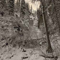
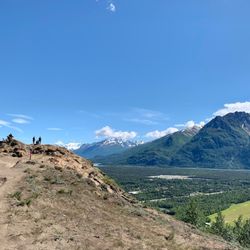
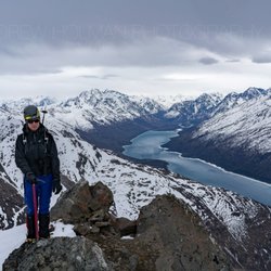
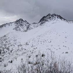
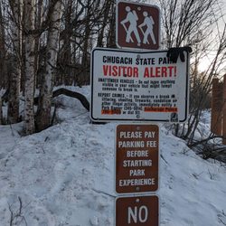
If you are going to do the Bodenburg Butte, you're going to want to use this trail opposite to the opposite side. But do not let me fool you, this is not for the weak. From Anchorage, follow Highway 1 north until you see a sign for the Old Glenn Highway proceeding into Palmer. A few miles after the footbridge on your right hand side, you will see a sign for Bodenburg Loop. You can either follow the loop all the way around. Or proceed down the Old Glenn then turn left on the second Bodenburg Loop sign, turning left on the second road, Mothershead Lane. You will see a little parking lot on this road. Unless you have a Mat-Su parking pass, to park here is $5. That means the Alaska State Park sticker you might have on your car is irrelevant. Up the road is where the West Butte Trail begins. The trail is pretty hill-y lots of ups and downs, after the hills come the switch backs and when you are ready, you will hit an endless amounts of stairs. The endless amounts of stairs lead you to the top of Bodenburg Butte. This is where all your hour of leg work becomes worth it. Atop provides a 360 view of Palmer, its farmlands, the Knik River as well as the Knik Glacier from afar.

We live in the Butte and after hiking the West Butte Trail today, it's a travesty that we haven't hiked it more often. It was an absolutely perfect day. For those like my husband and me, who aren't in the best shape, it is a bit difficult, but you have to keep your eye on the prize... the view from the top is incredible.

I've only used the trail on the south side of Butte, but I hear the north side is pretty great. I like how it's a short hike but has beautiful views of Palmer and Pioneer Peak. I have never paid for parking, but I noticed a sign and money drop system. I bet it's only enforced in the summer. When I went on Saturday it was just cool enough that there weren't many people on the mountain. Will come again.

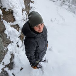
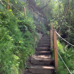
On an overcast morning, my friends and I decided to hike the trail. It wasn't very crowded which was nice and it was well maintained. The hardest part of this trail is the seemingly endless amount of stairs that pop up halfway through. But overcome that, and you will be left with an amazing view from the top of the butte. There were plenty of dogs on this trail if you wanted to bring your pet as well. Round-trip from the parking lot, this trail is 2.4 miles with an elevation gain of 819 feet. read more


If you're looking for a short hike to pass a couple hours, this is a good one. There are two entrances to the trail. One goes up a steep dirt path while the other contains stairs. It's a challenging up hill climb, but it's less than a mile to the top, so you're not exerting yourself long. The downhill is super fast. You're back in a blink, especially if you let gravity take over and you have a four legged friend on a leash pulling you... you may even end up face first in the dirt path (I, of course, wouldn't know anything about that). Bring your Eno since there are trees up top to hook them on. Bring binocular to check out the eagles flying by. Beautiful views of Lazy, Matanuska, and Pioneer, not to mention the Knik River Valley. read more


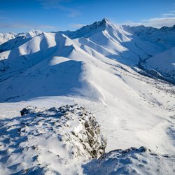
It's the Flattop of Palmer!!!! I need to start calling easy hikes the Flattop of *town*. This hike is way shorter, and way steeper than Flattop. It can be done in 30 minutes roundtrip without even trying. I like this though. The side I did (with the handmade-looking sign) was a VERY steep dirt trail for the first 1/4th of the way. If this thing was wet, it would turn into a slip-n-slide. If you hike it from the other side, I hear it's much more moderate in grade. This has the best clear-shot of Pioneer Peak you can get from anywhere. I'm adding this to me "check out in the winter" list as well. It would probably be a fantastic spot to hunt for the Northern Lights from. read more


11 years ago
If you are going to do the Bodenburg Butte, you're going to want to use this trail opposite to the opposite side. But do not let me fool you, this is not for the weak. From Anchorage, follow Highway 1 north until you see a sign for the Old Glenn Highway proceeding into Palmer. A few miles after the footbridge on your right hand side, you will see a sign for Bodenburg Loop. You can either follow the loop all the way around. Or proceed down the Old Glenn then turn left on the second Bodenburg Loop sign, turning left on the second road, Mothershead Lane. You will see a little parking lot on this road. Unless you have a Mat-Su parking pass, to park here is $5. That means the Alaska State Park sticker you might have on your car is irrelevant. Up the road is where the West Butte Trail begins. The trail is pretty hill-y lots of ups and downs, after the hills come the switch backs and when you are ready, you will hit an endless amounts of stairs. The endless amounts of stairs lead you to the top of Bodenburg Butte. This is where all your hour of leg work becomes worth it. Atop provides a 360 view of Palmer, its farmlands, the Knik River as well as the Knik Glacier from afar. read more

8 years ago
We live in the Butte and after hiking the West Butte Trail today, it's a travesty that we haven't hiked it more often. It was an absolutely perfect day. For those like my husband and me, who aren't in the best shape, it is a bit difficult, but you have to keep your eye on the prize... the view from the top is incredible. read more


9 years ago
I've only used the trail on the south side of Butte, but I hear the north side is pretty great. I like how it's a short hike but has beautiful views of Palmer and Pioneer Peak. I have never paid for parking, but I noticed a sign and money drop system. I bet it's only enforced in the summer. When I went on Saturday it was just cool enough that there weren't many people on the mountain. Will come again. read more


9 years ago
9 years ago
Are you looking for a somewhat difficult hike that doesn't take too long with incredible views? If so, then Bodenburg Butte is for you. It is about 900 feet of elevation gain in 1.5 miles. Definitely a good workout, but not a long one like some others I've been on. The hike starts out relatively easy and then you reach a bunch of stairs. The stairs go on and on and on....until they reach an incredible 360 degree view of Palmer. On a clear day, you can see the Knik Glacier, which we did. You also get a good view of farmlands, Pioneer Peak, and Lazy Mountain. The cost to park is $5 (I think it is covered by the Alaska state pass, but unsure as we were from out of town). The trail is further up the road from the parking. Two women we met at the top said there's a steeper way....not sure where that starts (and not sure I'd care to make this any harder than it already is). Worth noting that there is also an outhouse (not too terrible) in the parking area, which was a great stop before we went on this trail. read more


13 years ago
More info about Bodenburg Butte
Ask the Community - Bodenburg Butte


Why does Yelp recommend reviews?
Bodenburg Butte - hiking - Updated July 2026
Best of Butte
People found Bodenburg Butte by searching for…
Scenic Overlook in Butte, Alaska
Walking Trails in Butte, Alaska
Swimming Lakes in Butte, Alaska
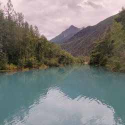
Beautiful Views in Butte, Alaska
Dog Friendly Trails in Butte, Alaska
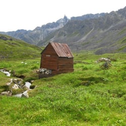
Hiking Trails in Butte, Alaska
Things to Do at Night in Butte, Alaska
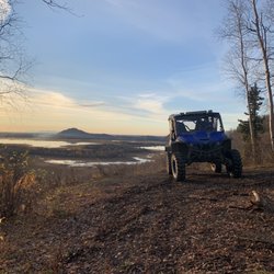
Off Road Trails in Butte, Alaska
Playgrounds for Kids in Butte, Alaska
Running Trails in Butte, Alaska
Browse Nearby
Browse Brands
Trending Searches in Butte, AK
Browse Articles
People who viewed Bodenburg Butte also viewed
Matanuska Peak Trail
2 reviews
Peters Creek Trailhead
2 reviews
East Twin Peak
1 review
Pioneer Falls
2 reviews
Fishhook Trailhead
2 reviews
Alaska Backcountry Adventure Tours
75 reviews
Palmer Hay Flats State Game Refuge
1 review
West Twin Peak
1 review
Eklutna Lakeside Trail
11 reviews
Matanuska River Park
5 reviews