4.5 stars.
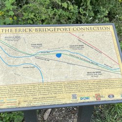
The Mahoning Sghadow Trail is a 15 mile rails-to-trails conversion that connects Valier, PA with the tiny hamlet of Winslow via the famous Punxsutawney, PA. It follows the right-of-way of the Pennsylvania and Northwestern Railroad Line, which served the coal industry in southern Jefferson County. The tracks west of Punxsutawney served the Eureka mines of the Berwind-White Coal Company. Along the way the hiker or cyclist will find a lot of hidden remains of the once flourishing coal and coke industries in the area, including several remnants of coke furnaces. A few of them have been restored with signs saying how and when they were used.
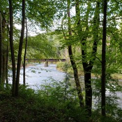
My husband Rick and I did a full 30 mile round trip on the trail. We began our ride at the western trailhead in Valier, PA. The trailhead is located on County Road 3015, Fordham Road, about 3/10s of a mile in from County Road 3013. Most on line maps will recognize the address I gave you above. Google Maps is best because it shows bike trails. It's best to start at this end of the trail because there is ample parking available. This section of trail follows the beautiful Mahoning Creek. After following the creek for a little bit, we encountered a second trailhead with limited parking along County Highway 3008. We headed NNE then turned south, passing Saints Peter and Paul Cemetery. We curved away from the creek for a bit, going through a wooded area intermixed with some small fields and homes before re-joining it at Gresock Road.
Coming in to Punxsutawney, we passed the Punxsutawney Water Treatment Plant and while that might not have been the historical or scenic highpoint, the remnants of 50 beehive coke ovens are located just west of here. We then crossed the creek on an old railroad bridge that has been re-decked for cyclists. Punxsutawney is the only major town on the trail, and as there are no restrooms or even water pumps or fountains along the way, it's an appropriate rest stop. There is a bit of a detour on city streets, however it's well marked.
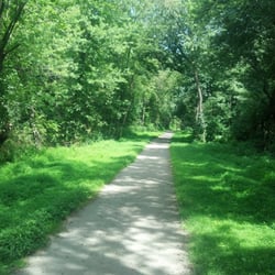
Leaving Punxsutawney we went through some beautiful woodlands along the creek. The eastern section runs along the tranquil Mahoning to the village of Cloe and from there strays from the waterway a bit. We noticed that the trail is interrupted in Cloe for about 1/4 mile or so. We had to use PA 236 tp pick up the trail again, however we noticed it is well marked. And while we thought the western half of the trail is pretty scenic, we really liked the eastern half. This half of the trail has some steep grades, especially for a former railway line. We climbed through the scenic highlands until we reached the small village of Hudson. There are some deep hemlock forests in through here too. We rode all the way to the eastern trailhead which is at County Raod 2001. The trail pretty much ends here with no parking available. Although it appears to cross the highway, it's a private driveway on the other side.
So we did a good 30 mile round trip and although the Mahoning Shadow Trail isn't the longest of our rails-to-trails, it's very scenic and it makes for a good morning's or afternoon's cycling. In addition to my usual bike trips, just remember there are no facilities along the trail except in Punxsutawney. read more