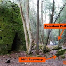
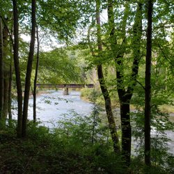
Sandy Creek Trail Photos


More like Sandy Creek Trail
Recommended Reviews - Sandy Creek Trail
Start your review...

One of the prettiest bike rides I've ever taken! This amazing rails to trail fully paved bike path is 24 miles round trip through some truly spectacular scenery and woodlands. The largest of 7 wooden bridges along the path spans the Allegheny River and the smaller ones cross several creeks. What you don't see are any roads along this gorgeous wilderness path. There is a slight upward grade during much of the 12 miles from Fishermans Cove to the end of the line - the good news is it's nearly imperceptible until you turn around and head back. You feel like you're flying on your return trip which is really fun! This area is the definition of remote so go prepared with food, water & flat tire supplies. There's decent cell service, so bring your phone. There is also a fairly long tunnel mid-trail with reflectors down the center. A light would likely make you feel a tad more comfortable on a cloudy day. The reflectors work decently to direct you on a sunny day. This bike trail is located slightly over an hour north of Cranberry Township. Google map Seneca Hills Bible Camp which is where you turn off Old Route 8 off I-80. At the T heading to the Bible Camp you head right to Fisherman's Cove to the trailhead. If you're interested in more information and specific directions, here is a link: www.avta-trails.org ' sandy-creek-trail read more


Wow. This is a spectacular trail!! Such a pleasant ride through the woods crossing the river and creek multiple times on a paved surface. I don't even know how they managed to get blacktop back into some of these remote areas but they did!! It's mostly shaded as well so even on hot days this would be a great choice when you just want to ride! We started at the western end of the trail called Fisherman's cove. A little tricky to find and accessible by a gravel road about 3 miles off old route 8. Parking here is limited and is roadside so I can imagine it getting pretty crowded on weekends. But it is so worth it. The eastern end is 12 miles out at Van. The ride back seemed a lot quicker since there appears to be a minor downhill heading back although it is an easy ride in both directions. The fact that it's quite remote means there are no road crossings so you can just ride completely carefree!! If you feel up to it you can extend the ride by joining up with other rails to trails and make a long day out of it!! We absolutely loved it and will no doubt be heading back there this fall to enjoy the ride and the scenery! Highly recommended!! read more
15 years ago
14 years ago
More info about Sandy Creek Trail


Sandy Creek Trail - hiking - Updated July 2026
Best of Franklin
People found Sandy Creek Trail by searching for…
Campgrounds in Franklin, Pennsylvania
Things to Do in Franklin, Pennsylvania
Off Road Trails in Franklin, Pennsylvania
Hiking Trails With Waterfalls in Franklin, Pennsylvania
Beautiful Views in Franklin, Pennsylvania
Scenic View in Franklin, Pennsylvania
Places to Take Pictures in Franklin, Pennsylvania
Day Trips in Franklin, Pennsylvania
Walking Trails in Franklin, Pennsylvania
Waterfalls in Franklin, Pennsylvania
Camping Cabins in Franklin, Pennsylvania
Picnic Areas in Franklin, Pennsylvania
Camping Sites in Franklin, Pennsylvania
Train Ride Kids in Franklin, Pennsylvania
Scenic Overlook in Franklin, Pennsylvania
View Points in Franklin, Pennsylvania
Playgrounds in Franklin, Pennsylvania
Secluded Spots in Franklin, Pennsylvania
Things to Do on a Rainy Day in Franklin, Pennsylvania
Scenic Restaurants in Franklin, Pennsylvania
Horseback Trail Rides in Franklin, Pennsylvania
Bicycles in Franklin, Pennsylvania
Trending Searches in Franklin, PA
Day Trips near Sandy Creek Trail
Fireworks near Sandy Creek Trail
Fishing Spots near Sandy Creek Trail
Places To Swim near Sandy Creek Trail
Public Shower near Sandy Creek Trail
Splash Pad near Sandy Creek Trail
Swimming Holes near Sandy Creek Trail
Swimming Lakes near Sandy Creek Trail
Browse Articles
Browse Nearby
BEST of Franklin, Pennsylvania Things to Do near Sandy Creek Trail
BEST of Franklin, Pennsylvania Coffee near Sandy Creek Trail
BEST of Franklin, Pennsylvania Restaurants near Sandy Creek Trail
BEST of Franklin, Pennsylvania Swimming Holes near Sandy Creek Trail
BEST of Franklin, Pennsylvania Breakfast near Sandy Creek Trail
BEST of Franklin, Pennsylvania Fishing near Sandy Creek Trail
BEST of Franklin, Pennsylvania Campgrounds near Sandy Creek Trail
Browse Brands
Related Searches in Franklin, PA
Affordable Bike Tune Up Services in Franklin, Pennsylvania
Affordable Cheap Bike Tune Up Services in Franklin, Pennsylvania
Best Dog Hiking Trails Around Franklin, Pennsylvania
Best Fishing Locations and Guides in Franklin, Pennsylvania
Best Fun Things to Do in Franklin, Pennsylvania
Best Nature Trails for Hiking in Franklin, Pennsylvania
Best Places for Horseback Riding in Franklin, Pennsylvania
Best Places for Stunning Views in Franklin, Pennsylvania
Best Spots for Star Gazing in Franklin, Pennsylvania
Best Waterfalls and Swimming Holes in Franklin, Pennsylvania
Check Out Off Road Trails in Franklin, Pennsylvania
Discover Popular Bike Trails in Franklin, Pennsylvania
Discover Popular Photo Spots in Franklin, Pennsylvania
Discover Scenic Creeks to Explore in Franklin, Pennsylvania
Discover Scenic Mountain Bike Trails Near Franklin, Pennsylvania
Discover Stunning Skyline View Spots in Franklin, Pennsylvania
Discover a Hiking Trail in Franklin, Pennsylvania
Discover the Best Night Hike Trails in Franklin, Pennsylvania
Enjoy Camping Adventures Around Franklin, Pennsylvania
Enjoy Hiking Adventures in Franklin, Pennsylvania
Enjoy Kayaking Adventures in Franklin, Pennsylvania
Enjoy Tent Camping Spots Around Franklin, Pennsylvania
Enjoy the Best Night View Spots in Franklin, Pennsylvania
Enjoy the Best Tubing Experiences in Franklin, Pennsylvania
Experience Stunning Sunset Views in Franklin, Pennsylvania
Explore Beautiful Parks and Green Spaces in Franklin, Pennsylvania
Explore Bike Rentals Throughout Franklin, Pennsylvania
Explore Easy Hikes Perfect for All in Franklin, Pennsylvania
Explore Family-Friendly Zoos and Wildlife in Franklin, Pennsylvania
Explore Free Things to Do Around Franklin, Pennsylvania
Explore Nature Spots Around Franklin, Pennsylvania
Explore Popular Campgrounds Near Franklin, Pennsylvania
Explore Popular Scenic Overlook Points in Franklin, Pennsylvania
Explore Popular View Points Around Franklin, Pennsylvania
Explore Scenic Lakes to Visit in Franklin, Pennsylvania
Explore Top Dog Parks in Franklin, Pennsylvania Near You
Explore the Best Boating Spots in Franklin, Pennsylvania
Explore the Best Swimming Holes Around Franklin, Pennsylvania
Explore the Best Trail Options in Franklin, Pennsylvania
Explore the Scenic River in Franklin, Pennsylvania
Find Beautiful Views in Franklin, Pennsylvania
Find Fun Kids Activities Outdoor in Franklin, Pennsylvania
Find Parks and Recreation Activities in Franklin, Pennsylvania
Find Specialized Bikes and Accessories in Franklin, Pennsylvania
Find Top Mountain Bike Rental Options in Franklin, Pennsylvania
Find Top-Rated Waterfalls in Franklin, Pennsylvania Now
Find a Fixed Gear Bike Shop in Franklin, Pennsylvania
Find the Best Bikes Available in Franklin, Pennsylvania
Find the Best Swimming Pools in Franklin, Pennsylvania Today