Cancel

    Open app

    Search

    Ma Ka Ja Wan Scout Reservation

    5.0 (4 reviews)

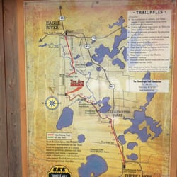
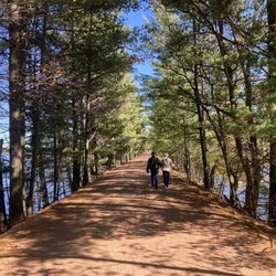
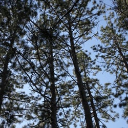
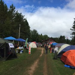
    Ma Ka Ja Wan Scout Reservation Photos

    More like Ma Ka Ja Wan Scout Reservation

    Recommended Reviews - Ma Ka Ja Wan Scout Reservation

    Your trust is our priority, so businesses can't pay to alter or remove their reviews. Learn more about reviews.
    Yelp app icon
    Browse more easily on the app
    Review Feed Illustration

    8 days ago

    Helpful 0
    Thanks 0
    Love this 0
    Oh no 0

    4 years ago

    Helpful 0
    Thanks 0
    Love this 0
    Oh no 0
    Photo of Michael B.
    103
    135
    21

    10 years ago

    Helpful 0
    Thanks 0
    Love this 0
    Oh no 0

    12 years ago

    Helpful 0
    Thanks 0
    Love this 0
    Oh no 0

    Verify this business for free

    Get access to customer & competitor insights.

    Verify this business

    Big Bear Rocky Vista

    Big Bear Rocky Vista

    5.0(3 reviews)
    23.8 mi

    The view was definitely worth the trip! Directions from the previous review are spot on. After you…read moreturn on Knowles Creek Rd from CTH F follow that until you see the lake on your right. Immediately after the lake you will see a little driveway on your left that leads to a campsite. After that you are looking for the 3rd road on the left(road number 2781. It is marked with a small vertical wooden sign that is somewhat hidden by weeds but pretty easy to spot). I'm not sure the exact distance, but it was a few minute drive past the campsite till you reach the 3rd road on the left. Take a left on road 2781 and follow it until you come to a fork in the road where road number 2349B splits off to the right(there is a large mud hole at the start of this trail). At this point you will need to abandon your vehicle and begin hiking. Hike down the road 2349B until you come to another fork in the roadway. When you reach this fork take the trail that goes up hill (this trail goes off to the left and has a few broken off trees at the start of it). From there its a short hike up hill until you reach one of the most beautiful views in the northwoods! The total hike round trip is right around 2 miles. Shoes that can get muddy and bug spray are also definitely a must for this hike! I made the driving portion of this trip in my all wheel drive BMW X1. It made the trip ok, however driving down road 2781 was a bit of a nail biter as there are some bigger stones in the roadway and a few larger mud holes that a 2 wheel drive vehicle may not have made it through. That being said road 2781 is definitely definitely more of an offload trail with 2 tire tracks that you drive on and no place to turn around until you get to the fork for road 2349B. I would recommend a 4 wheel drive truck or suv for this journey, or just parking on the side of Knowles Creek Rd and hiking from there. Doing this would only about another mile to the hike. Also you may be able to drive down road 2349B if you have a Wrangler or similar vehicle. I also recommend stopping at the lake you pass on Knowles Creek Rd and getting some beautiful pictures! There is a small campsite that you can turn off into if it isn't occupied and spend a little time taking in the beauty of the lake.

    YES. After many hours of searching to no end...on multiple days...we have finally discovered this…read moreproudly hidden gem, so titled The Big Rock. Hopefully this review will lead you right to the site and save you all the hours of endless exploration, but this is mostly serving as a note-to-self...to help me find this place in the future :-) Soooo starting from downtown Lakewood, WI: Head north on F until you hit Knowles Creek Rd, turn left. Continue on Knowles Creek until there comes a fork in the road. At the fork, follow Knowles Creek to the left and do NOT continue straight/right-ish onto McCaslin Tower Rd. Continue on Knowles Creek, where you should see a sort of lake on the right and then a campsite further down on the left. After these two "markers", look for the 2nd trail on the left with one of those mini-snowmobile stop signs. The correct trail should be numbered 2781. Follow this trail (in the car is still fine, but watch for huge puddles/deep mud) until you can literally drive no further. You should then see a sort of pathway at the end on the left that is somewhat upward sloping at first. At this point, abandon your vehicle and begin walking up the clearing (there is typically a puddle or mud of some sort at the start of this path). Walk for a bit (1/2 mile?) and keep your eyes out for an uphill path on the left side of where you are walking (in my experience, there has been a partially fallen tree trunk marking the base of this hill). Follow the path up this hillside to the top, at which point, you have reached The Big Rock! The total walking time is minimal and, round-trip, clocks in at around 2 miles. You'll know when you've reached your destination because the view is breathtaking! Now supposedly, this is a geocaching site (I have included the URL in my creation of this business listing), so there are instructions and coordinates on how to reach the place on that as well. In my two trips to The Big Rock, I have yet to discover where the cache is located...we searched for quite a while on both occasions and were unable to find the box. So good luck to all future enthusiasts with that endeavor; as for me, I'll be lounging on that huge rock over there enjoying the view :)

    Photos
    Big Bear Rocky Vista
    Big Bear Rocky Vista
    Big Bear Rocky Vista - Beautiful view.

    See all

    Beautiful view.

    Public Recreation Area 19 - Larger area map of Michigamme Reservoir and Way Dam

    Public Recreation Area 19

    3.0(1 review)
    66.5 mi

    This is a good way to use Yelp for my own sake... OK, this place is not a must-see tourist…read moreattraction in Upper Michigan but it has a special attraction - driftwood. If you like driftwood for decorative purposes, here's the place! Seems lots of North Woods cabins have some driftwood in their yards, or people craft things using driftwood. Here's a great beach for finding it. The place is about 8 miles off the major highway and is hard to get to. If anything, by writing this review, it will help me remember how to find it next time. Going northbound from downtown Crystal Falls along US-141, turn right at Fisher Road. These are all gravel backroads from here on. Continue on Fisher, then turn left on Balsam Road. Once you get to WPA Road, you'll see a sign for Recreation Areas 17 & 19. Turn right and continue towards Area 19. There will be some twist and turns but keep going. You'll see a lake and a boat landing area. The actual driftwood beach is a little walk down a hiking path. The beach is lined with wooden stairs to sit and watch the water. Off to the side is a wooded area with all kinds of driftwood washed ashore. Some are dog-fetching stick size and others are 12-footers that would require two people to carry them out of the water. The lake is part of the Way Dam hydroelectric project, so water levels can vary. Happy hunting!

    Photos
    Public Recreation Area 19 - Driftwood on sand

    Driftwood on sand

    Public Recreation Area 19 - Map of Area 19 on Michigamme reservoir

    Map of Area 19 on Michigamme reservoir

    Public Recreation Area 19 - View of lake

    See all

    View of lake

    Ma Ka Ja Wan Scout Reservation - hiking - Updated May 2026

    Loading...
    Loading...
    Loading...